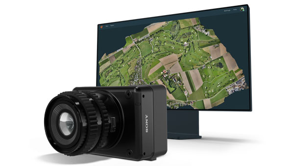
Wingtra has launched the MAP61 mapping sensor, designed to assist professionals in generating larger mapping outputs more efficiently. This ultra-high-resolution sensor offers detailed 3D data in a single pass, providing valuable analytics for vertical assets.
The MAP61 can cover up to 460 hectares (1,140 acres) in a single flight, reducing fieldwork time and enhancing productivity. According to Julian Surber, product manager at Wingtra, the MAP61 can decrease fieldwork time from one hour to approximately 35 minutes while doubling processing speed. This efficiency is beneficial for projects requiring both 2D and 3D data.
MAP61 features oblique sensor configuration, which can facilitate detailed mapping of long structures such as highways without interrupting traffic flow. This design reduces the need for cross-hatch flights, cutting field time in half for vertical resolution and accuracy, which is critical in industries such as construction.
The MAP61 is versatile and suitable for various applications including land management, urban planning, highway mapping and progress monitoring in open-pit mines. Its ability to operate efficiently in challenging environments — such as urban areas or open pit mines —makes it a valuable tool for professionals who need timely data.
The system can integrate seamlessly within an intuitive mapping workflow. Wingtra combines vertical take-off and landing (VTOL) capabilities with its software platform, WingtraCLOUD. This integration allows users to plan, capture and process data without switching between different software applications.
Towering at 25 m, the barrel vault of the Grote Kerk in Naarden showcases an extraordinary work of art. The five-century-old paintings above the nave and choir are astonishingly well-preserved, with every panel remaining intact. (Photo: Stichting Grote Kerk Naarden)
The Grote Kerk in Naarden, Netherlands, often called the “Sistine Chapel of the North,” is undergoing a 3D scanning project to uncover the secrets of its medieval ceiling murals. The digital research initiative aims to illuminate the long-standing mysteries surrounding the artwork’s origins, including the artists’ identities and the precise timeframe of their creation.
Researchers from various Dutch universities are collaborating to create a detailed digital 3D model of the church’s barrel vault. Using 3D scanning technology, the team produces high-resolution digital mural replicas. These scans will enable researchers to examine the artwork more precisely, revealing intricate details in brushwork and pigmentation that are invisible to the naked eye. This in-depth analysis could potentially lead to the identification of the artists and provide new insights into the techniques and materials they used.
This project serves a dual purpose: uncovering historical information and preserving cultural heritage. The digital models will act as a permanent record of the artwork, ensuring its preservation for future generations and increasing accessibility through online platforms.
Student involvement and restoration planning
Before the commencement of large-scale restoration efforts, students can explore and work within the church. The technology allows for comprehensive documentation of the expansive painted surfaces. Additionally, students are tasked with developing strategies to support the restoration process, such as creating digital models to test potential interventions without risking damage to the actual vault.
The project covers 700 square meters of painted planks and beams. Following the completion of the research and scanning phases, the restoration process is expected to take two and a half years and require an investment exceeding $2 million.
As this project progresses, researchers are optimistic that their work will unveil new aspects of Grote Kerk’s artistic legacy, providing a more profound understanding of this significant piece of Dutch cultural heritage.
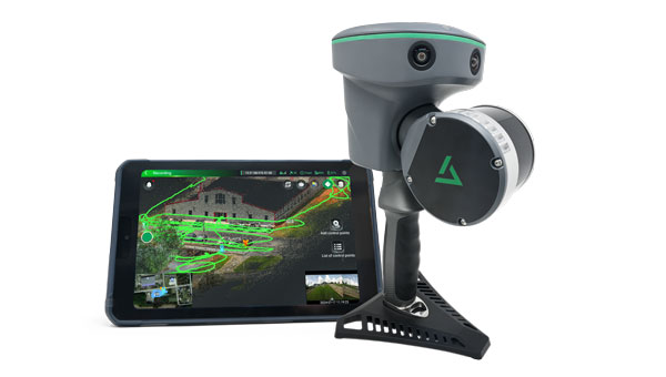
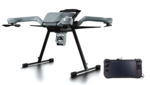
GeoCue has introduced the TrueView GO handheld mapping system, designed for reality capture and detailed 3D mapping. The system can be used for surveying, civil engineering, construction, urban planning and forestry.
The TrueView GO series includes the 16-channel 116S and the 32-channel 132S models and integrates GNSS real-time kinematics (RTK), survey-grade lidar scanning, cameras and visual SLAM technologies. These features allow users to create real-time digital twins in indoor or outdoor environments.
The series offers a comprehensive set of features ideal for handheld mapping. The device provides real-time SLAM capabilities, displaying georeferenced point clouds live on a tablet for instant adjustments and thorough coverage.
It can operate in areas with weakened or denied GNSS signals, making it suitable for indoor and urban surveys. The TrueView GO also enables remote measurement of inaccessible areas by collecting reference points from a distance. Its SLAM technology, when combined with RTK, allows for loop-free path planning, eliminating the need for traditional loop closure and overlap and reducing project completion time and distance when GNSS coverage is available.
The handheld mapping scanner features LP360 LAND. This geospatial software is specifically designed for processing handheld lidar and imagery data. LP360 LAND seeks to enhance data accuracy using robust QA/QC tools, 3D point cloud processing and visualization and capabilities such as SLAM, denoising, colorization, registration and classification.
LP360 LAND can handle diverse applications, including data classification, tree segmentation, volume calculation and export to BIM using both desktop and cloud environments.
A roundup of recent products in the GNSS and inertial positioning industry from the July 2024 issue of GPS World magazine.
MAPPING
Mobile Mapping System With integrated inertial labs INS/lidar
The Meridian mobile mapping system integrates the Mosaic X camera with Inertial Labs inertial navigation system (INS) and lidar to improve mapping accuracy.
The Meridian system offers panoramas with a 74 MP native resolution and 13.5 K resolution using precisely synchronized camera modules. The design minimizes image overlap to offer clearer and more consistent panoramas. The integrated INS system has a vertical accuracy of 2 cm to 3 cm and a precision of 2 cm to 4 cm.
It features seamless, out-of-the-box operations with fully integrated and calibrated components. The Meridian system is designed for ease of use and requires only minutes of training. In addition, it features a rugged design to ensure performance in challenging environments.
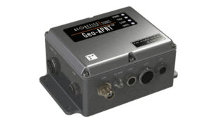
The Geo-APNT serves applications requiring precise navigation data and an accurate time reference. The Geo-APNT combines a versatile GPS master clock with an INS to
offer assured positioning, navigation and timing (PNT) under all circumstances, including temporary loss of GPS signal. It minimizes size, weight and power (SWaP) due to the integration of positioning and timing that are typically achieved by two independent subsystems.
It can be easily integrated into existing systems and supports RTK and PPK positioning and offers support for MEMS, fiber optic gyro and ring laser gyro inertial measurement units (IMUs). The system also includes GPS antenna and cables.
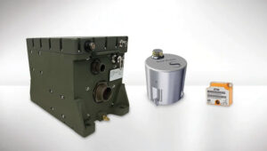
This line of tactical-grade IMUs is engineered to address the evolving needs of unmanned applications and 2 space-based operations.
The IMUs include Iconyx, a high-performance HRG-based IMU that significantly outperforms legacy technologies, the company says. It offers improved accuracy and reliability for demanding navigation needs. It also features a small tactical IMU (STIM) ideal for applications requiring lower size, weight and power (SWaP).
The company is upgrading its Geonyx inertial navigation system (INS), which is based on HRG technology, to incorporate M-Code capability. The fully integrated solution can perform in GPS- denied or spoofing environments, offering reliable navigation in challenging environments.
GPS-Aided INS For land, marine and aerial applications
The INS-FI, a GPS-INS, is designed for enhanced performance and reliability across various platforms including land, marine and aerial applications.
The INS-FI is built with tactical-grade fiber optic gyroscope (FOG) technology and an IP67 rating, indicating its robustness and resistance to electromagnetic and environmental interference. This system integrates an IMU that combines fiber optic gyroscopes and MEMS accelerometers, along with an all-constellations GNSS receiver supporting multiple bands.
It offers horizontal and vertical positioning with approximately 0.1% error of distance traveled for land applications and a drift of five nautical miles per hour for aerospace applications without GNSS signal. INS-FI is fully compatible with Inertial Labs’ Air Data Computer (ADC), visual inertial navigation systems (VINS) and a stand-alone magnetic compass (SAMC).
INS-FI incorporates sensor fusion filter technology, navigation and guidance algorithms and calibration software to ensure optimal performance and reliability. The system aims to provide precise horizontal and vertical positions, velocity, and absolute orientation (heading, pitch and roll) for any mounted device, maintaining high accuracy for both stationary and dynamic applications.
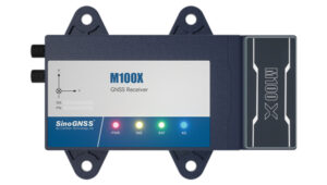
The M100X GNSS receiver is built with the Quantum-III SoC Chip, designed to provide full-constellation and multi-frequency capabilities, specifically engineered for high-accuracy vehicular positioning and heading.
The M100X features GNSS/INS integrated technology to provide real-time high- precision positioning, velocity and heading data, even in challenging environments.
The receiver provides accurate positioning and heading information across various applications, including autonomous mining trucks, intelligent ports, mapping and autonomous buses. It is designed to safeguard vehicles as they pass through areas with poor signal reception, even in obstructed environments such as urban canyons, city overpasses, underground garages, tunnels and parks.
The M100X has a data update rate of up to 100Hz, allowing it to perform well in
very dynamic environments, such as vehicles traveling at high speeds. This rapid update capability enables continuous and real-time tracking of vehicle positions for reliable computation and instant updating of navigation information. It also facilitates quick responses to changes in vehicle dynamics during travel. These features are essential for maintaining seamless operation in high- speed environments and ensuring high levels of safety and performance.
Constructed with aluminum alloy and rated IP67 for water and dust resistance, the receiver is built to withstand harsh operational environments. It also features a shock-resistant design, capable of surviving a drop from 1 m without damage. It can connect to 4G, LAN, Bluetooth and multiple I/O ports for seamless integration with various systems and networks.
The M100X can be used with the Navigation Master software, an Android app for quick device configuration and effective remote management. Using Bluetooth connectivity, users can configure their M100X devices for optimal performance. Additionally, its cloud platform, NaviCloud, offers instant access to projects and data from any location.
Spirent has implemented Xona Space Systems’ PULSAR production signals for seamless integration into the existing SimXona product line. The PULSAR X1 production signal implementation has passed Xona certification and the PULSAR X5 signal verification process is currently underway. It is expected to pass certification during the summer of 2024. Spirent is now accepting orders for SimXona with production signals capability.
Xona is developing PULSAR, a high-performance PNT service built on a backbone of low-Earth orbit (LEO) small satellites. Xona’s smallsat signals will improve PNT resilience and accuracy by augmenting GNSS while operating with an independent navigation and timing system architecture. Xona is fully funded to launch its production class satellite, the In-Orbit Validation mission, in 2025.
Spirent is the leading provider of PNT test solutions and recently launched a sixth-generation simulation system, PNT X. Designed for navigation warfare (NAVWAR) testing, PNT X is an all-in-one solution with native implementation of SimXona.
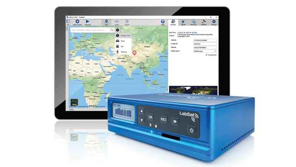
The LabSat 4 GNSS simulator is designed to meet the demands of modern GNSS signal testing. It is equipped with three radio frequency channels, each of which can be configured with up to 12-bit I&Q quantization and a bandwidth of up to 60 MHz. This allows users to precisely control recording parameters and optimize file sizes based on their specific testing requirements. Additionally, synchronized record and replay of external data sources such as CAN, CAN-FD, RS232 and digital event capture are designed to further enhance complex test scenarios.
Users can save custom record settings for efficient setup and repeatability. Additionally, a user-friendly, web-based interface allows for easy configuration and management of the simulation environment.
LabSat 4 offers file management capabilities with 7.6 TB internal storage and robust data transfer options via Gigabit Ethernet and USB 3.0. This technology accommodates the high- volume data needs of modern GNSS testing without sacrificing speed or performance.
It is small, portable and cost-effective, making it suitable for use both in the field and in the laboratory. LabSat 4 is fully compatible with SatGen Simulation Software, which allows users to create GNSS RF I&Q scenario files based on custom trajectories. This integration enables the simulation of scenarios involving multi-stop routes, time zone transitions, leap seconds and more, using any specified time, date and location.
BroadSim Duo is a dual-frequency GNSS simulator designed specifically for testing military receivers in an unclassified environment.
BriadSim Duo integrates dual-frequency capabilities within a single compact GPS military signal testing unit. The simulator has dual-frequency capability, which is essential for testing P-Code and AES-M-Code. It features a new software-defined radio in an M.2 form factor, offering robust and reliable performance. It also seamlessly integrates with the Skydel simulation environment for improved versatility and functionality.
Adtran has released two optical cesium atomic clocks, the OSA 3300 Super High-Performance (OSA 3300 SHP) and the OSA 3350 Super Enhanced Primary Reference Clock+ (OSA 3350 SePRC+). The devices use optical pumping technology to meet evolving demands across applications from scientific research to critical PNT infrastructure.
The OSA 3300 SHP offers stability and accuracy, making it a valuable tool for metrology institutes and scientific research facilities. The OSA 3350 SePRC+ is specifically designed to enhance holdover capabilities for PNT services.
It maintains 100 days of 100-nanosecond precision, providing continuous and accurate timing even in environments where GNSS is compromised or unavailable. This makes it a crucial
component for ensuring the integrity of mission-critical networks and supporting vital infrastructure and defense operations with reliable backup timing.
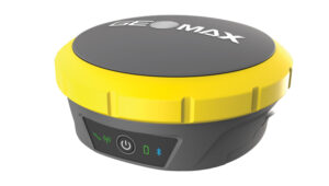
The Zenith60 Pro GNSS smart antenna is designed for surveyors and construction professionals. It is a real-time kinematics (RTK) rover that features calibrated free tilt compensation to measure otherwise inaccessible points. The antenna is suited for harsh climates, urban areas, dense canopy coverage or other challenging terrains.
This multi-constellation, multi-frequency GNSS receiver features a GNSS board with more than 800 channels and IP68 protection against dust and water. It also connects with GeoMax total stations and X-PAD field software to create an efficient and flexible workflow.
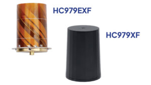
The HC979XF antenna is designed to provide optimal support for the entire GNSS band, including GPS/QZSS L1/L2/L5 (QZSS L6), GLONASS G1/G2/G3, Galileo E1/E5a/b/E6, BeiDou B1/B2a/b/B3, NavIC L5 and L-Band corrections services.
The key new feature of the HC979XF and HC979EXF antennas is the support for Galileo’s Global High Accuracy Service (HAS) and QZSS’s regional Centimeter Level Augmentation Service (CLAS). Both correction services are broadcast in the E6/L6 band (1258- 1300 MHz).
The radio frequency spectrum has become congested worldwide due to the activation of many new LTE bands. Their signals or harmonic frequencies can affect GNSS antennas and receivers.
In North America, the planned Ligado service, which will broadcast in the frequency range of 1526 to 1536 MHz, can affect GNSS antennas that receive space-based L-band correction service signals (1539 – 1559 MHz). New LTE signals in Europe [Band 32 (1452 – 1496 MHz)] and Japan [Bands 11 and 21 (1476 – 1511 MHz)] have also affected GNSS signals. Calian’s XF models are designed to mitigate the effects of these new signals.
The Calian HC979XF housed helical antenna weighs 42 g and is enclosed in a military-grade IP69K plastic enclosure. The embedded HC979EXF helical antenna weighs 8 g. It is easily mounted with an optional embedded helical mounting ring, which traps the outer edge of the antenna circuit board to the host circuit board or any flat surface. An MCX connector is installed in the base of the antenna.
WingtraCLOUD software is designed to simplify data collection and streamline the onboarding of surveyors and pilots.
WingtraCLOUD offers a user-friendly flight planning experience, plus time-saving features including site-based file organization, advanced 3D planning, coordinate system by sites and improved connectivity via cloud syncing in a single environment.
It aims to simplify and streamline site setup and team collaboration. WingtraCLOUD’s features accelerate planning and introduce anew level of transparency among stakeholders with enhanced wireless functionality. Users can now provide insights to regional and global site managers across projects.
WingtraCLOUD allows users to maximize Wingtra aerial data and services, offering UAV program scaling and business advantages across a variety of industries.
FLYC-300 is designed 2 for advanced applications in UAVs, unmanned ground vehicles (UGVs) and autonomous mobile robots. Weighing 297 g, the FLYC-300 features a low size,
weight and power (SWaP) form factor and delivers 100 TOPS AI performance. It supports autonomous navigation, object detection, real-time inference, and SLAM capabilities.
The FLYC-300 is suitable for industries such as inspection, logistics, rescue operations, security, agriculture and environmental monitoring. It supports a variety of sensors and cameras, accommodating RGB, infrared, hyperspectral, HDR and high-resolution cameras. It can seamlessly integrate with flight controllers, vehicles or robots.
The computer can operate with a wide voltage input range from 4S to 14S battery packs or 12 V to 60 V DC input via the XT30 DC-IN connector, making it versatile for different unmanned systems. It also supports 5G or 4G modules for real-time transmission of images, videos and data. The computer is available in two configurations, with or without an enclosure, to meet varying application needs.
The VTOL hangar drone combines the JOUAV JOS-C800 hangar with its new VTOL fixed-wing UAV, CW-15V.
This “drone-in-a-box” solution isdesigned to offer amore efficient and versatile solution for businesses looking to optimize their routine operations through automated aerial technology.
The JOS-C800 hangar system is composed of an automated hangar, a newly developed VTOL fixed-wing drone CW-15V, and the Jocloud management platform. This system enables complete management and monitoring of automated aerial missions through cloud-based remote operations.
Its key features include autonomous takeoff and landing, intelligent flight planning, automatic charging, data management, intelligent data analysis and report generation, enabling fully automated drone operations without the need for on-site personnel.
The JOS-C800 uses AI and AR algorithm integration to classify and identify potential hazards in the collected data, supporting the display and management of these hazards on Jocloud, and generating detailed hazard classification reports. The upgraded algorithms allow for real-time stitching and comparison of video data comparative analysis to identify new or changed hazards.
It supports multi-UAV, multi-hangar operations with staggered takeoffs, allowing for hop-and-fly operations. The CW-15V UAVs can be paired with various payloads such as gimbal cameras, lidar and oblique cameras.
INVOLI, a specialist in cooperative air traffic surveillance solutions, has partnered with MatrixSpace to create a comprehensive air traffic awareness solution through a unified platform.
The partnership combines INVOLI’s cooperative detection technology with MatrixSpace’s advanced non-cooperative detection capabilities, facilitated by miniaturized primary radar technology. This integration allows for complete surveillance of both airborne and ground-based traffic, significantly enhancing UAV detection, counter unmanned aircraft system (CUAS) capabilities and safety for beyond visual line of sight (BVLOS) operations.
The integrated solution is designed to be low in size, weight, power and cost (SWaP-C), and can be deployed quickly without the need for additional infrastructure or specialist training. This makes it suitable for a variety of applications, including surveillance of sensitive sites such as prisons and energy infrastructure, as well as supporting safe and efficient BVLOS UAV operations.
NavStorm-M is a gun-hardened integrated anti-jamming GPS receiver for artillery, bombs, missiles and unmanned systems.
It features a layered protection approach using beamforming, anti-spoofing, resiliency and software assurance. It is an assured positioning, navigation and timing (A-PNT) device featuring M-Code GPS technology. It offers GNSS protection of two bands (L1/E1+L2 or L1 + G1 or L1/E1 + L5) from up to three directions of jamming simultaneously.
NavStorm-M is designed to meet the tight size, weight, power and cost (SWaP-C) requirements of unmanned aircraft systems, loitering munitions, hypersonic platforms and other weapons — especially in gun-hardened applications. NavStorm-M offers precise GPS navigation as a stand-alone system or integrated with an INS.
GPSdome2 is a high-end anti-jamming and fully retrofit solution tailored for defending manned and unmanned ground vehicles and UAVs from jamming attacks. It can be integrated with various GNSS off-the-shelf receivers. Using up to four off-the-shelf active antennas, with dual-band protection — GPS L1+L2 or GPS L1+Glonass G1 — it protects from up to three jamming directions simultaneously in each band. With optional mil-spec compliance, it can serve smaller and lighter platforms.
Atlas is a Group II loitering munition with robust capabilities in air, land and sea tactical scenarios. With a flight duration of more than two hours and a striking distance comparable to larger Group III aircraft, Atlas delivers mission flexibility and performance.
Designed for high-impact scenarios, it supports a range of operations such as intelligence, surveillance, and reconnaissance (ISR)/detect, identify, locate and report (DILR), electronic warfare and direct-action engagements. The munition’s payload includes options for fragmentation or penetration effects, further enhanced by optional ISR capabilities.
Zoe M4 is a portable and foldable quadcopter platform designed to rapidly deploy an overwatch capability for military personnel and units. It is easy to transport and set up, making it ideal for security, ISR (intelligence, surveillance, and reconnaissance), and emergency response applications.
It is equipped with the NextVision Raptor X80, a military-grade EO/IR gimbal that offers stabilized daytime and night-time imagery with 80x zoom and thermal imaging in high resolution. The NDAA-compliant quadcopter features the same rugged capabilities as the base Acecore Zoe model, including a robust carbon fiber construction, an all-weather waterproof design and the ability to survive winds of up to 29 knots.
The Zoe M4 is paired with Acecore’s Signav Ultra ground control station (GCS), a lightweight handheld device based upon the Panasonic FZ-M1 tablet and rated to MIL-STD-810G. It can be factory-configured for compatibility with existing military networks or frequency bands between 1625 to 2510 MHz.
Aptella has partnered with Sphere Drones, an Australian-based full-stack technology and UAV provider, for Aptella to distribute the Sphere Drone HubX mobile payload platform. The platform supports autonomous scanning and mapping operations for users across the resources, mining, construction and emergency services sectors.
HubX is a mobile solution designed for drone-in-a-box (DiaB) or terrestrial scanning tasks in regional and hard-to-access locations. Its self-sustained, mobile form factor makes it readily deployable on any site. Its bespoke solar power system and the 5G/satellite internet solutions are backed by built-in redundancies.
The HubX platform offers a versatile and large configurable payload bay, allowing users to mix and match enterprise payloads to meet their specific needs and enhance remote data collection. This includes seamlessly integrated DiaB and terrestrial scanner payloads, as well as the ability to plug and play any third-party payload hardware.
When paired with DJI’s Dock 2, HubX simplifies DiaB operations, enabling businesses to be operational on the day of delivery and have pilots ready to fly within 30 minutes of arrival. This setup accelerates the adoption of UAV operations and facilitates the transition to beyond visual line of sight (BVLOS) operations.
Obtaining certification to operate UAVs via a remote operations center (ReOC) is typically a complex and time-consuming process. However, the HubX solution streamlines this with a managed service offering, the company said.
Aptella, with locations across all states and territories of Australia, Southeast Asia and New Zealand, supports the civil construction, building, mining and geospatial industries. Under the agreement, Aptella will provide HubX demonstrations and initial deployments, working in collaboration with Sphere Drones for technical support.
Built between 1817 and 1825, the Erie Canal provided a water route from Albany to Buffalo, New York, nearly 363 miles to the west. The Canal connected the Hudson River with the Great Lakes via parts of the Mohawk River, through various land cuts and natural lakes.
Photo: NOAA
Today, NOAA cartographers from the Marine Chart Division are converting paper nautical charts to a digital format and incorporating them into NOAA electronic navigational charts (NOAA ENC). NOAA created its suite of ENCs by digitizing its paper nautical charts. An ENC is a vector database that supports all types of marine navigation. Marine navigators can use the system to see their real- time position in relation to features on a chart.
Marine navigators using NOAA ENC. (Photo: NOAA)
By digitizing the paper Erie Canal charts, NOAA can now provide ENCs for the canal from Albany to Lake Ontario. As part of the digitizing process, NOAA cartographers standardized the chart scales covering the canal, moving away from the 64 irregularly shaped paper charts in chart 14786, New York State Canal System.
1:10,000 SCALE NOAA Custom Chart output near Waterford, New York. (Photo: USGS/NOAA)
The ENC is the primary nautical navigation product of the agency, which is ending the production and maintenance of its traditional paper and raster nautical chart products. The remaining paper charts are only being updated with critical corrections until they are fully canceled. Chart 14786 will be one of the last ones canceled, on Dec. 5, 2024.
Now, marine users are referred to the NOAA Custom Chart Application. It is an online map tool for users to create paper and PDF nautical charts derived from the official NOAA ENC.
Trimble and Esri have extended their partnership to enhance collaboration in geographic information system (GIS) software, location intelligence and mapping. This ongoing effort aims to improve processes, support decision-making, and automate workflows for greener infrastructure planning, construction and operations for users.
The companies are exploring emerging technologies, particularly in industry data models that support accurate generative AI technologies and workflows. Trimble’s geospatial field systems, which collect location intelligence and 3D datasets, are enhancing workflow support in Esri ArcGIS Indoors and the ArcGIS Utility Network.
Trimble Unity — a new asset lifecycle management suite — leverages Esri’s GIS into construction project and capital planning, enterprise asset management and permitting solutions to improve how universities, healthcare facility operators, utilities and federal, state and local government jurisdictions track the asset management lifecycle.
Trimble and Esri also partnered with The HALO Trust, the world’s largest landmine-clearing non-profit organization, which combined Trimble’s high-accuracy mapping technology with Esri’s ArcGIS software to improve the capacity to locate and remove landmines and other explosive hazards, making communities safer.
Inertial Labs has integrated its RESEPI lidar solution into ideaForge UAVs. The integration seeks to improve lidar mapping capabilities and is suitable for mining, forestry, geographic information system (GIS) and land surveys, water resources management and more.
The UAVs equipped with RESEPI offer a vertical accuracy of 2 to 3 cm. The precision is maintained at 2 to 4 cm and it excels at a flight height of 50-100 m. The integration enhances the capabilities of ideaForge UAVs, offering users accurate and reliable data for mapping and surveying applications.
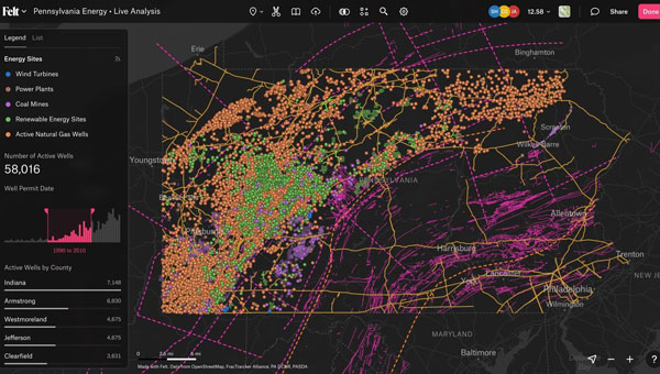
Felt has introduced Felt 3.0, which includes new features and native database integrations to improve Geographic Information Systems (GIS) capabilities. The goal of Felt 3.0 is to make data more accessible and actionable for stakeholders. It provides modern GIS tools for teams to visualize, analyze and present important insights and map data relevant to their operations.
The company released version 2.0 in November 2023, which introduced UI and spatial analysis tools. This was the first step towards allowing users to gather insights from geospatial data for recruiting, analytics, management and more. Now, with Felt 3.0, teams can connect their database directly to Felt and build interactive components and dashboards tailored to their specific workflow.
Felt 3.0 allows users to directly connect Postgres/PostGIS and Snowflake databases and keep the data fresh with automated live data updates. Support for other third-party data sources, including Databricks, Amazon’s S3 and Redshift, Google’s BigQuery, and SpatioTemporal Asset Catalogs (STAC), will be available soon.
Developers can also use Felt’s new API to reduce engineering time for custom geospatial app implementations. The API allows users to create and style elements and listen to map updates via webhooks, while providing a Python SDK for professionals to continue to work in their preferred tools.
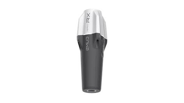
Emlid has released upgrades for its ultralight Reach RX Network real-time kinematics (RTK) rover. It features MFi (Made for iPhone/iPad) certification and is fully compatible with ArcGIS, QGIS and other GIS apps for both iOS and Android. Reach RX can be seamlessly integrated into GIS workflows to help industry professionals and teams collect accurate geodata at scale.
Reach RX offers precise positioning while receiving corrections through NTRIP. The device tracks GPS/QZSS, Galileo, GLONASS and BeiDou. It gets a fix in less than 5 seconds, delivering centimeter-level accuracy even in challenging conditions.
The rover does not require configuration or additional training— surveyors only need to add NTRIP credentials. With its intuitive and straightforward workflow, Reach RX allows users to achieve high precision for engineering, utility inspection, landscaping and other projects of any scale.
According to the company, the rover will soon be compatible with QField, Blue Marble’s Global Mapper, Mergin Maps, Avenza Maps and more.
The Reach RX rover weighs 250 grams. The battery provides 16 hours of operation on a single charge and can be recharged from a power bank. The receiver works in a variety of survival environments. The IP68-rated rover is waterproof, dustproof, and withstands temperatures from -20 to +65°C (-4 to 149°F).
3Dsurvey has launched 3Dsurvey 3.0, an all-in-one photogrammetric software solution.
3Dsurvey 3.0 is a hardware-agnostic solution designed to unify diverse data sources such as lidar sensors, cameras UAVs and various ground control points. The platform allows users to transition between orthophotos, point clouds and textured meshes, streamlining workflows without exporting files. This integration can benefit survey professionals, enhancing data accuracy and overall efficiency.
Version 3.0 features upgraded coordinate system functionalities to obtain georeferenced spatial data without the drawbacks of complex local transformations, which can reduce accuracy. These enhancements eliminate the need for third-party software.
3Dsurvey 3.0 has several features designed to improve geospatial data processing. Among the key updates is the improved coordinate system support, which handles transformations requiring special grid files. This upgrade ensures highly accurate GPS-to-local coordinate conversions. Additionally, the platform can automatically fetch missing geoid models, simplifying user workflow.
The revamped coordinate system selection process includes presets for users to find the correct system by simply entering their country name, with the appropriate settings applied automatically. It has PRJ file support to enhance compatibility with various GIS standards.
The new Clip function allows users to manage and share 3D models and orthophotos. By integrating CAD capabilities, users can import or create CAD lines within 3Dsurvey to define specific areas of interest, improving efficiency and data sharing.
In my last newsletter, I highlighted the release of a beta version of a new NOAA CORS Network (NCN) Station Web Page. As demonstrated in my newsletter, each CORS in the NCN has its own page with data, metadata, maps and photos for that station displayed in a modular layout so information is easily found all in one location. This past month, I had the privilege of participating in a meeting with representatives from the American Association for Geodetic Surveying (AAGS), the National Society of Professional Surveyors (NSPS) and the National Geodetic Survey (NGS). As a Past President of AAGS and the current Chair of the AAGS Membership Committee, I participate in these quarterly meetings.
AAGS aims to lead the community of geodetic, surveying, and land information data users through the 21st century. AAGS members develop new educational programs, including presentations, seminars, and workshops on topics related to geodetic surveying; and articles and papers that inform the membership of the latest scientific and technological developments and how to implement them in the most cost-effective and efficient manner.
In my previous newsletters, I have reminded everyone that time is running out to obtain a working knowledge of the new, modernized National Spatial Reference System (NSRS). The release of the new, modernized NSRS is only about a year away. As of July 2024, NGS plans to have a beta version of the new, modernized NSRS available around the summer of 2025 for users to test and evaluate new products and services. After enough testing has been performed, the new, modernized NSRS will be officially published – probably in early to mid-2026.
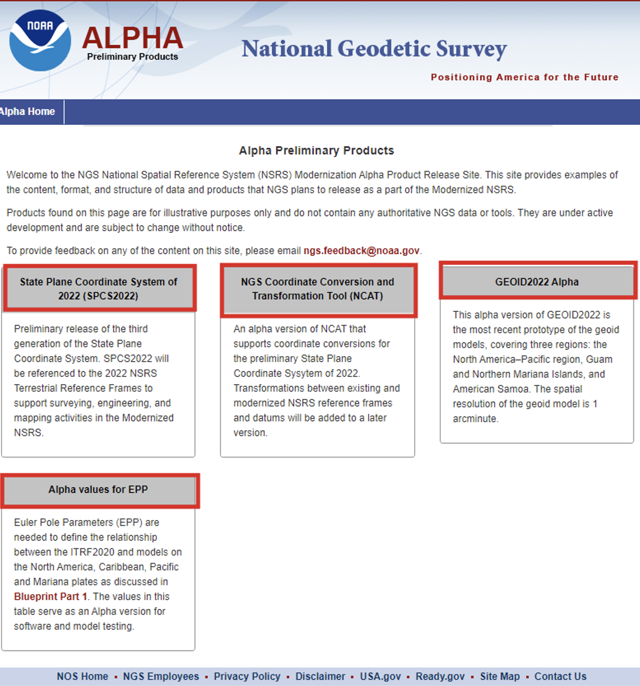
At the meeting, NGS highlighted some new products on its Alpha Preliminary Products site. The alpha site provides products that are useful for individuals who want to obtain a better understanding of the products that will be distributed as part of the new, modernized NSRS.
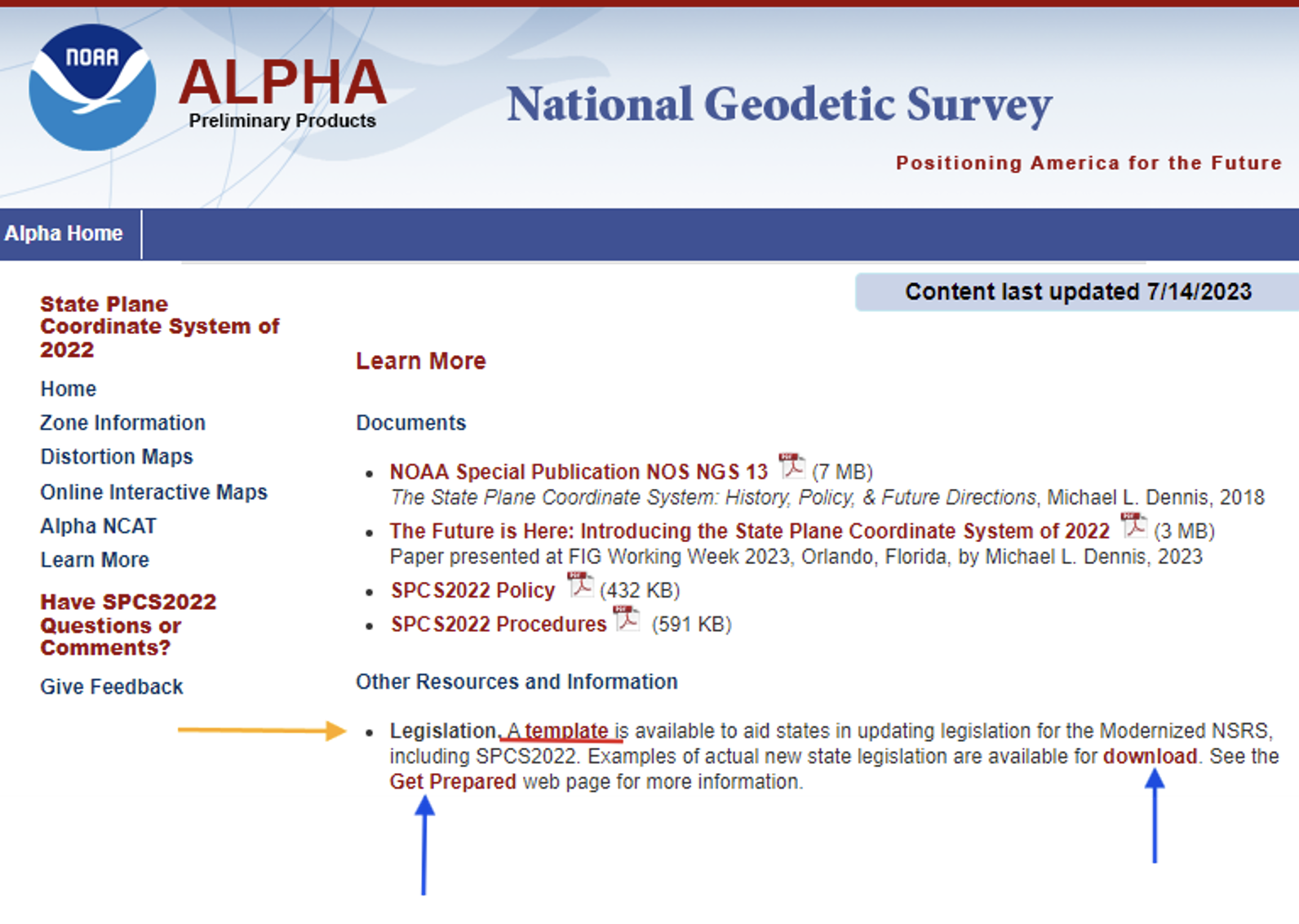
First, I want to bring attention to the importance of ensuring that the state’s legislation is modified or rewritten, if required, to include that the current horizontal and vertical datums are being replaced with the new, modernized NSRS. The “Learn More” button on the SPCS2022 Alpha site provides information about legislation.
Per personal communication with Michael Dennis, Ph.D., NGS SPCS2022 Manager, as of June 26, 2024, the following 12 states have have enacted into law NSRS modernization: Alaska, Idaho, Iowa, Kansas, Kentucky, Louisiana, Nebraska, North Carolina, South Dakota, Vermont, Washington, and Wyoming.
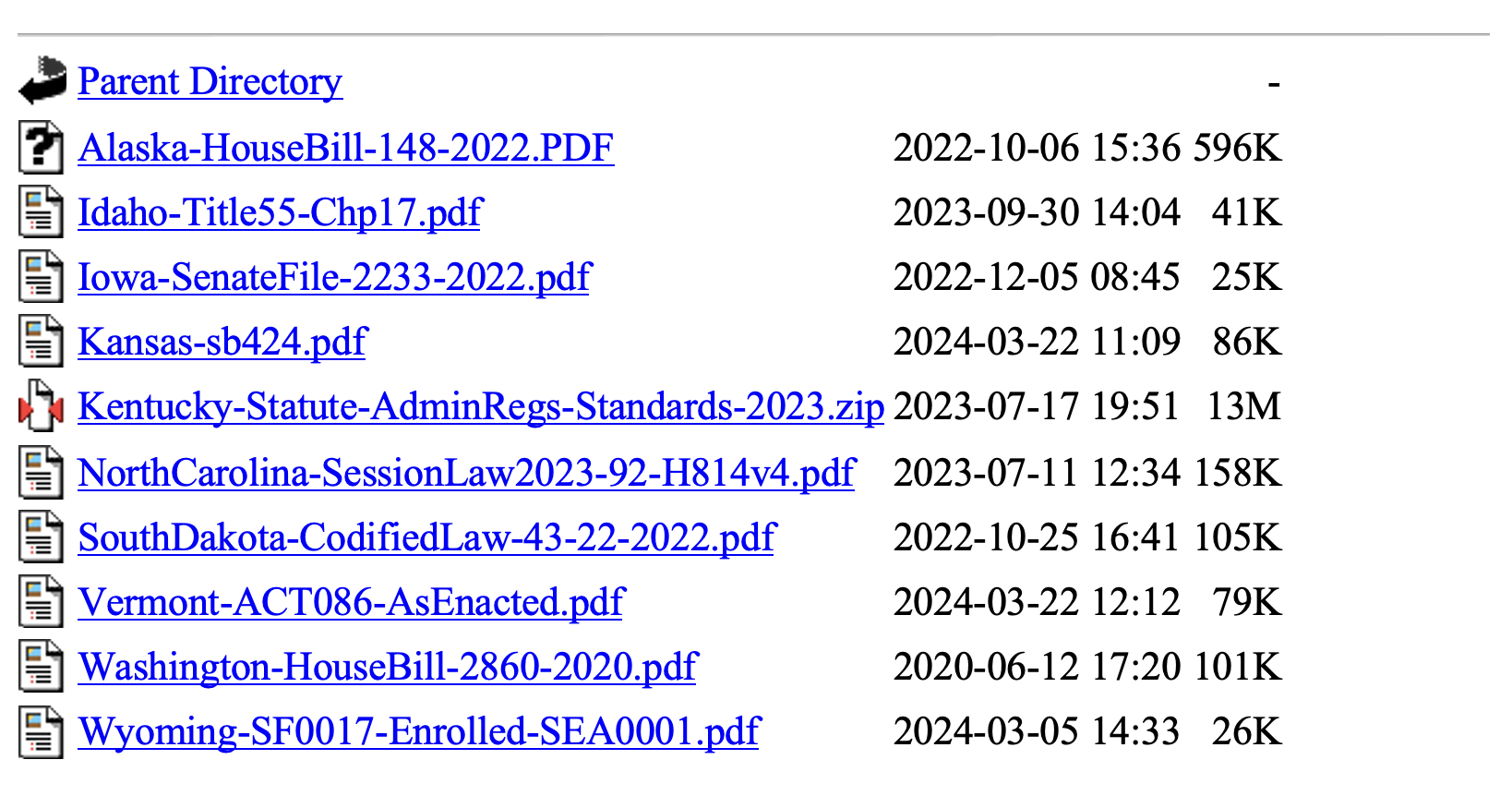
Users can download examples of actual new state legislation here.
Examples of legislation.
During the joint AAGS/NSPS/NGS meeting, Tim Birch, the executive director of NSPS, said that anyone who has questions about updating legislation for the new, modernized NSRS, including SPCS2022, can contact him directly.NSPS has experience working with agencies and individuals to develop legislation as indicated in the following statement on the NSPS website.
“We are the voice of the professional surveying community in the US and its territories. Through its affiliation agreements with the respective state surveying societies, NSPS has a strong constituency base through which it communicates directly with lawmakers, agencies, & regulators at both the national and state level. NSPS monitors and comments on legislation, regulation, & policies that have potential impact on the activities of its members and their clients, and collaborates with a multitude of other organizations within the geospatial community on issues of mutual interest.”
As previously stated, the two latest alpha products are the “GEOID2022 Alpha” and “Alpha Values for EPP.” My December 2017 newsletter discussed GEOID 2022 and the North American-Pacific Geopotential Datum of 2022 (NAPGD2022), and my February 2022 newsletter discussed the Euler Pole Parameters process and use in the new, modernized NSRS.
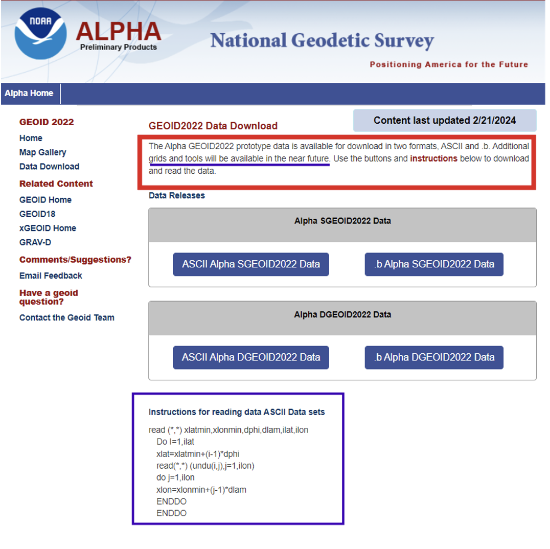
The GEOID2022 Alpha page provides a version of GEOID2022, which is the most recent prototype of the geoid models. The reference ellipsoid is Geodetic Reference System 1980 (GRS 80, but the geometric reference frame is ITRF2020). The Alpha GEOID2022 prototype data is available for download in two formats, “ASCII” and “.b.” There is a static component (SGEOID2022) and a dynamic component (DGEOID2022). These grids will be useful to programmers who want to develop and test their systems. Additional grids and tools will be available in the future.
Technical Details of the Alpha prototype of GEOID2022
GEOID2022 alpha is the last prototype of GEOID2022. It covers three regions: the North America–Pacific region, Guam and Northern Mariana Islands, and American Samoa. The spatial resolution of the geoid model is 1 arcminute. The geoid heights, which are in the tide-free system, are with respect to the reference ellipsoid of the Geodetic Reference System 1980 (GRS80) in the ITRF2020 geometric reference frame. GEOID2022 alpha includes static and dynamic components for the geoid heights. For detailed fundamental parameters of the geoid model, refer to NOAA Technical Report 78.
GEOID2022 Alpha
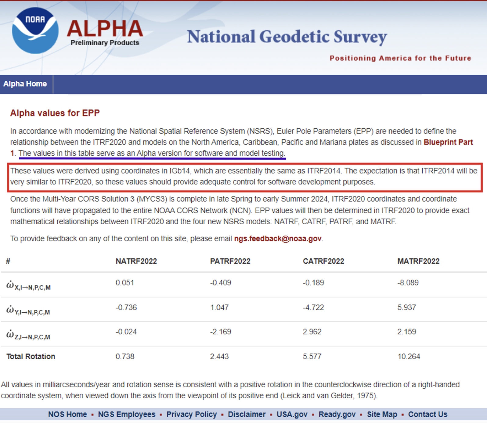
The Alpha EPP site provides the Euler Pole Parameters (EPP) that are needed to define the relationship between the ITRF2020 and models on the North America, Caribbean, Pacific and Mariana plates as discussed in NGS’s Blueprint Part 1 document.
Alpha Values for EPP
As stated in Blueprint Part 1, NGS will define the official relationship between ITRF2020 and the four NSRS TRFs through equation 59, using the rotation matrix in equation 58 resulting in equation 60.
I programmed this using a simple Excel spreadsheet to compute some of the potential changes between epochs for North Carolina. They were very similar to the ones that I depicted in my February 2022 newsletter that discussed the Euler Pole Parameters process and provided plots depicting the movement.
I would like to highlight the latest information available on the State Plane Coordinate System of 2022 alpha site. As previously stated, in about a year, the new, modernized NSRS will be available as a beta product. Users must get prepared by accessing NGS’s alpha products as well as taking the opportunity to provide feedback to NGS to improve their products and services. The Online Interactive Maps page provides information about the zones for every U.S. state and territory.
Clicking on the Online Interactive Maps link opens a NOAA ArcGIS online website that provides information about the Alpha State Plane Coordinate System 2022 preliminary zone designs. I have highlighted a few items that may be of interest to users.
The site provides a description of the site, links to various types of zones, links to data sources and information about distortion.
SPCS2022 online interactive maps.
Clicking on the link for zone definitions provides a list of zones and their parameters. This same information is also provided when users click on a zone on the map. I will demonstrate this later in this newsletter.
Per personal communication with Dennis, as of June 26, 2024, seven states have some or all their SPCS2022 zone definitions formally finalized, consisting of 205 out of the 965 zones (the total number of zones is still preliminary):
Alaska (partial coverage multizone layer)
Arizona (both multizone layers)
Idaho (both multizone and statewide)
Kentucky (both multizone and statewide)
North Carolina (statewide zone; it has no other zones)
South Dakota (both multizone and statewide)
Wisconsin (multizone)
Dennis informed me that the information on the alpha SPCS2022 Experience has been updated. He told me that the total number of zones decreased from 967 to 965, but based on coordination with the International Association of Oil & Gas Producers (IOGP) Geodesy Subcommittee the number may eventually increase to 972 (more about that in a future newsletter).
He stated that his goal is to finalize the zone definitions by the end of this calendar year or early 2025. Users should keep checking the alpha site.
Dennis mentioned that the website now offers a new feature that provides the distortion value when users click on the map. A nice thing about that is the site can be used on a smartphone, allowing users to obtain real-time distortion information from their location.
Clicking on the link titled “View” in the upper right corner of the box brings up a map that depicts the SPCS2022 zones.
View of ALPHA (preliminary) SPCS2022 zone designs.
When you click on the note about the ALPHA being preliminary, the map underneath appears where the user can select the type of maps they wish to review.
The following options are available: All Zone Layers, Statewide Zone Layers, Multizone Complete Layers, Multizone Partial Layers, and Special Use Zone Layers.
Users can use their mouses or the “+” button on the left-hand side” to zoom to a particular region, or use the search button on the right-hand side to select a State or zone.
Using the search box.
Information about a particular zone pops up by clicking on a point on the map.
Detailed information provided for a zone.
Each zone provides links to other features based on the location of the point selected on the map.
The image below provides the distortion in ppm for the point selected on the map.
The Alpha NCAT site can be used to obtain an estimate of the changes between SPCS83 and SPCS2022. It should be noted that all values will be in meters (m) and international feet (ft).
International feet may be new to some surveyors who were previously using the U.S. survey feet in SPCS83. The U.S. survey foot will not be used with the NSRS, including SPCS2022 coordinates. NGS and the National Institute of Standards and Technology (NIST) have taken action to deprecate the U.S. survey foot. What does that mean?. NIST has the following statement on its website: “Beginning on January 1, 2023, the U.S. survey foot should be avoided, except for historic and legacy applications, and has been superseded by the international foot.” This means that NGS will not be publishing SPCS2022 in U.S. survey feet but all historic products and services such as SPCS83 will still be provided in U.S. survey feet (sft) and international feet (ift).
More information and resources about the deprecation of the sft are listed below (personal communication from Dennis):
The official announcement is the final determinationFederal Register Notice (FRN) on deprecation of the sft issued on 10/5/2020. It was jointly issued by the National Institute of Standards and Technology (NIST) and NGS. I encourage everyone concerned about this topic to read it closely and in its entirety; it can likely answer most questions. The FRN includes information on the continued use of sft for legacy applications (such as SPCS 83). That is stated in the last paragraph of the “Notice of Final Determination” section; in items #1 and #2 in the “Counterpoints to Feedback Expressing Opposition”section; and in the second paragraph of the “Implementation Summary and Actions” section.
The legacy issue is also addressed in the 10th FAQon the NIST website and in the 11th FAQon our “new datums” FAQs web page.
The 40 states that officially adopted the sft for SPCS 83 are listed in Table C.1 of Appendix C of NOAA Special Publication NOS NGS 13, “The State Plane Coordinate System History, Policy, and Future Directions.”
Although the final determination FRN is itself not a law, Congress has passed several laws giving NIST the authority to maintain national standards of measurement. These and other related federal laws are given in the initial sft FRNissued on 10/17/2019.
An NGS webinar given on 11/10/2022 addresses the deprecation of the sft in the context of state plane. Two previous NGS webinars also provide additional background and historical information on the sft, one given on 4/25/2019 and the other on 12/12/2019.
Input to Alpha NCAT.Photo:Output from Alpha NCAT.
This newsletter highlighted the products on NGS’s Alpha Preliminary Products site. The alpha site provides products that can be useful for individuals to obtain a better understanding of the products that will be distributed as part of the new, modernized National Spatial Reference System (NSRS). NGS is providing these products on an alpha site so that they can get feedback from users. I would encourage all users to access the alpha sites and provide comments to NGS so that their products and services better meet the needs of the surveying and mapping community.
Welcome to the NGS National Spatial Reference System (NSRS) Modernization Alpha Product Release Site. This site provides examples of the content, format, and structure of data and products that NGS plans to release as a part of the Modernized NSRS.
Products found on this page are for illustrative purposes only and do not contain any authoritative NGS data or tools. They are under active development and are subject to change without notice.
To provide feedback on any of the content on this site, please email [email protected].