Upgraded flagship mobile platform to power commercial smartphones from ASUS, Honor, Motorola, vivo and Xiaomi in second half of 2021
Photo: Qualcomm
Qualcomm Technologies Inc. announced the Snapdragon 888 Plus 5G Mobile Platform, a follow-on to the flagship Snapdragon 888. These two platforms power more than 130 designs announced or in development. The product was introduced at Mobile World Congress, taking place this week in Barcelona, Spain.
Satellite systems supported include all four constellations (GPS, Beidou, Galileo, GLONASS) with dual-frequency GNSS. Additional systems supported include NavIC, QZSS and SBAS.
Snapdragon 888 Plus provides AI-enhanced gameplay, streaming, photography and premium connectivity. Compared to its predecessor, Snapdragon 888 Plus offers an increased Qualcomm Kryo 680 CPU Prime core clock speed at up to 3.0 GHz and the 6th generation Qualcomm AI Engine with up to 32 TOPS AI performance, which is more than 20% improvement.
“Snapdragon is synonymous with premium Android experiences. Our latest flagship Snapdragon 888 Plus 5G Mobile Platform will help deliver the premium entertainment, connectivity, and gaming experiences users deserve,” said Christopher Patrick, senior vice president and general manager, mobile handset business, Qualcomm. “We’re excited to see OEMs launch with products based on our highest performing platform.”
Rx Networks TruePoint.io global precise point positioning (PPP) correction service now provides quad-constellation support.
More mobile devices are integrating multi-constellation GNSS chipsets for better positioning. With quad-constellation expanded multi-constellation support, Rx Networks TruePoint.io global precise point positioning (PPP) correction service unlocks that accuracy, providing global PPP corrections for every major GNSS constellation those chips can track.
TruePoint.io global PPP originally delivered GPS and GLONASS corrections. Now, it also provides corrections for Galileo and BeiDou. Mass-market multi-constellation GNSS chipsets can now augment all their satellite measurements with accuracy and fully leverage their positioning capabilities with quad-constellation support.
Consumer devices now have the potential to achieve 50-cm position accuracy when using Rx Networks services for any of the four GNSS constellations. Other internet of things (IoT) and infrastructure applications that do not require real-time positioning can realize 10-cm accuracy in a variety of environments.
Multi-constellation correction capability ushers in new possibilities and use cases for the connected receiver, according to Rx Networks.
TruePoint.io remains ubiquitous and as flexible as possible to GNSS chipsets using industry standard formats, and is also receptive to custom integration services for unique usage scenarios. By offering PPP and other high accuracy services in a variety of data standards, TruePoint.io empowers telecom providers with a straightforward approach to integrating high- accuracy services that provide more value to their client devices, and propels the development of exciting new use cases.
“With this new expansion of TruePoint.io, applications already serviced by Rx Networks can accelerate their market growth objectives with better accuracy and precision using constellations ideal for target regions,” said Vincent Chen, product manager of Truepoint.io. “Being able to deliver global PPP corrections for GPS, GLONASS, Galileo and BeiDou also sets the stage for the addition of more constellations like QZSS. Stay tuned.”
The company’s TimePictra 11 timing infrastructure management system works with its BlueSky GNSS Firewall to create a unified view for a more secure network timing architecture
Image: Microchip Technology
Microchip Technology Inc. has integrated its BlueSky GNSS Firewall with its TimePictra 11 synchronization monitoring and management platform to protect 5G networks and other critical timing infrastructure from GPS signal jamming and spoofing while providing single-console visibility across the entire timing architecture.
The move was made to meet the needs of 5G wireless infrastructure, which has more complex and higher density synchronization needs than previous generation networks. 5G is highly dependent on the integrity of live-sky GNSS timing signals.
“Microchip’s TimePictra system improves overall situational awareness by managing network timing synchronization as well as our GNSS firewall that improves a network’s resilience through real-time GPS threat detection and mitigation,” said Randy Brudzinski, vice president, Frequency and Time Systems business unit. “Our solution’s scalability is particularly valuable for mobile operators who can use TimePictra to monitor GNSS-based source clocks along with our secure network-based timing distribution solutions to deploy a highly resilient timing architecture for their transition to 5G.”
In addition to requiring precise timing from GNSS sources, critical infrastructure operators need accurate timing to be distributed across their networks so they can ensure reliable performance and service delivery. TimePictra provides full control and monitoring for resilient timing architectures created with Microchip’s broad product portfolio, including its TimeProvider 4100 grandmasters for 5G network synchronization.
TimePictra also monitors the health and performance of these networks’ distributed Precision Time Protocol (PTP) client clocks. Integrating BlueSky GNSS Firewall management into the TimePictra console view gives operators a unified picture of the entire timing architecture and all timing sources.
Beyond supporting 5G deployments, TimePictra provides aviation, railway and maritime ports with a regional, national or global view of GNSS reception. TimePictra with BlueSky GNSS Firewall monitors key GNSS observables to detect live-sky signal anomalies and deliver early alerting so that operators can engage alternate procedures that do not rely on GNSS. These capabilities are increasingly important when public safety depends on position and navigation for daily operations.
Microchip’s TimePictra timing infrastructure management system with its Blue Sky GNSS Firewall is available today.
Hexagon AB has launched HxGN Connect, a software-as-a-service (SaaS) workspace for citywide collaboration enabling government agencies and other organizations to share data and coordinate action for ad-hoc, routine and emergency situations.
Hosted in Microsoft Azure, HxGN Connect provides a networked workspace and unified view of information within and between entities. Participants can actively collaborate and securely share data as events unfold, overcoming technical and political barriers that result in missed opportunities, conflicting actions, errors and delays.
With HxGN Connect, organizations can move beyond basic cooperation to true collaboration, where all participants gain mutual value. HxGN Connect is easily implemented and scaled — whether between multiple departments in a single agency or multiple organizations across cities and regions.
“The future of smart cities lies in connected data communities that enable users to work with people and information irrespective of organizational and geographical affiliations or technology limitations,” said Hexagon President and CEO Ola Rollén. “HxGN Connect reimagines collaboration, breaking down barriers and bridging gaps between vertical sectors, organizational types and operational functions, which means safer cities, more effective services and happier residents.”
HxGN Connect brings a city’s public safety, transportation, utilities and other related organizations together seamlessly. While users can visualize people, places and activities, and send messages and assign tasks to each other, all participants retain full ownership and control of their own data (nothing is stored in a central repository).
The HxGN Connect dashboard. (Screenshot: Hexagon AG)
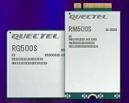
Quectel Wireless Solutions, a global supplier of modules for the internet of things (IoT), has announced the release of two new 5G New Radio (NR) module series, the RG500S and RM500S.
Based on the new Qualcomm 315 5G IoT Modem-RF System, both modules can support customers in building dedicated 5G devices for a variety of verticals including industrial IoT, retail, smart energy, private 5G networks, and many others.
The RG500S and RM500S both integrate a multi-constellation GNSS receiver, which simplifies the product design and provides accurate positioning services for users.
Utilizing the powerful Qualcomm 315 5G IoT modem, the RG500S and RM500S support extended-life software maintenance, helping create long-lasting IoT devices for the duration of their life span. Offering seamless integration, the RM500S is pin-to-pin compatible with Quectel’s LTE Cat 4 module EM05, Cat 6 module EM06, Cat 12 modules EM12-G/EM12xR-GL, Cat 16 module EM160R-GL and 5G module RM500Q, which provides more competitive 5G solutions to the IoT market. These features will help accelerate the 5G IoT market in the industrial and consumer IoT segments with use cases across robotics, automation, intelligent manufacturing, energy distribution, precision agriculture, construction, and mining.
Photo: Quectel
The RG500S and RM500S modules support 5G NR sub-6GHz bands in stand-alone mode offering backward compatibility with LTE networks. With network slicing in stand-alone mode, the two modules are able to offer end-to-end traffic isolation for critical traffic, guaranteed data rates and bandwidth, and lower latency than in non-standalone mode, which meets the demands of ultra-reliability and service-level agreements of typical industrial and enterprise scenarios.
The two modules are embedded with rich interfaces and incorporate high-speed USB 3.0/3.1, PCIe 3.0, U(SIM), RGMII and more, making them suitable for diversified industrial and consumer 5G applications such as industrial routers, robots, automation, intelligent manufacturing, smart cities, energy distribution, precision agriculture, construction and mining.
“Quectel has long been collaborating with Qualcomm Technologies to support the enablement of the 5G market in IoT,” said Patrick Qian, CEO, Quectel. “Based on the latest Qualcomm 315 5G IoT modem, the RG500S and RM500S are able to offer greater possibilities for the industrial and commercial IoT verticals. Features such as high performance and low latency as well as extended life software maintenance address the existing IoT market needs and can power a range of new 5G IoT use cases.”
“The Qualcomm 315 5G IoT modem solution was introduced to stimulate and scale the 5G IoT industry and enable the transitions needed to make 5G for IoT a reality. This solution is pin-to-pin compatible with legacy modules, which can accelerate device development and commercialization and promote growth and expansion in the 5G IoT industry. Integrating Qualcomm Technologies’ purpose-built modem into Quectel’s RG500S and RM500S modules will help deliver 5G to the IoT industry across industrial and enterprise applications,” said Jeffery Torrance, senior vice president, product management, Qualcomm Technologies.
Using artificial intelligence (AI), the oneNav receiver improves accuracy and reliability for location-dependent applications and services.
A new L5-only GNSS receiver is now available from oneNav. The mobile receiver provides high location accuracy with half the footprint of existing solutions.
OneNav has signed a strategic partnership agreement with In-Q-Tel Inc., providing U.S. intelligence and defense agencies with a GNSS technology solution that is the first of its kind, according to the company. The company also closed a $21 million Series B funding round, led by GV, with participation from Norwest Venture Partners and GSR Ventures, bringing total funding to $33 million.
“Navigation satellite constellations are getting a major upgrade — L5 signaling. oneNav has built the first Pure L5 mobile receiver to leverage these modernized signals, and we will deliver our solution in a flexible licensing model, as a scalable and customizable IP core,” said Steve Poizner, co-founder and CEO of oneNav. “I’m proud to be working with such an outstanding team of GNSS experts, as well as our top-notch investors GV, Norwest and GSR.”
“Pure L5 is a more cost-, size- and power-efficient method to enable the benefits of modernized signals compared to current hybrid solutions,” added Paul McBurney, oneNav co-founder and CTO.
Other GNSS solutions that fuel location-based services — rideshare, smartphone navigation and 911 emergency calls — depend on L1 satellite signals developed in the 1970s. According to oneNav, legacy L1 systems can have significant accuracy deficiencies, especially in dense urban areas, placing users on the wrong side of the street or on the wrong block.
L1 signals are also susceptible to jamming. Recently, satellite constellations have been upgraded with state-of-the-art L5 signaling. L5 enables higher accuracy, broadcasts in a protected frequency band, has modern error correction and is transmitted at higher power.
OneNav’s Pure L5 solution is built from the ground up to fully leverage modernized L5 signals from the GPS, Galileo, Beidou and QZSS navigation satellite constellations. Unlike current L1+L5 hybrid solutions that must first acquire on L1, oneNav’s Pure L5 solution both acquires and tracks on the new L5 signals, without L1 aiding, thereby taking full advantage of L5 benefits.
By eliminating the need for L1 circuitry, oneNav cuts GNSS RF size, power and cost in half. Supercharged by AI/machine learning, oneNav Pure L5 delivers much higher accuracy, even in challenging areas such as urban canyons. OneNav Pure L5 is ideal for highly space-constrained devices such as smartphones, wearables and IoT tracking modules. The solution is delivered in a semiconductor IP license package that includes register-transfer level (RTL), software and reference designs that can be integrated into a system on a chip (SOC) or built as a discrete chip.
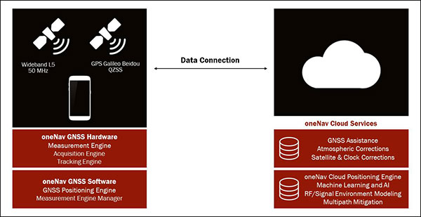
The oneNav L5 mobile GNSS system architecture. (Image: oneNav)
Pure L5 Use Cases
OneNav’s technology will dramatically improve location-based services that are used every day by individuals across the world to pinpoint their location. Common use cases include:
Rideshare. Today’s mobile positioning technologies often place users on the wrong side of the street, or on the wrong block, making rideshare services very difficult to use. oneNav enables riders to more effectively match up with their drivers in downtown areas and other heavily blocked environments.
Smartphone Navigation. It is sometimes difficult to establish your exact location, or to determine which way to turn when using a mobile navigation application in a dense urban area. oneNav’s high availability and precise accuracy enables reliable turn-by-turn directions.
Emergency Calls. First responders need to accurately pinpoint the location of accidents in order to get to the right place quickly. oneNav’s reliable positioning and high accuracy get the right location information to ambulances, fire and police, enhancing public safety.
Asset Tracking. COVID-19 has increased the need for supply-chain assets to be transported and tracked with precision. oneNav enables accurate position reporting for asset tracking and other IOT applications.
“The mobile device industry — from phones to wearables — has made tremendous progress over the last 20 years,” said Karim Faris, GV general partner. “What’s surprising is that location-based services continue to have a significant margin of error, which can make all the difference when locating a rideshare passenger or pinpointing an emergency situation. With oneNav’s Pure L5 Mobile GNSS receiver, OEMs and application service companies will have the opportunity to provide their customers with state-of-the-art location-based services, driving competitive advantage.”
After 15 years of planning and development, the ShakeAlert earthquake early warning system is now available to more than 50 million people in California, Oregon and Washington, the most earthquake-prone region in the conterminous U.S.
ShakeAlert provides alerts to the general public through public alert systems such as TV, radio and mobile phones. It also slows down trains, opens firehouse doors, closing water and gas valves and
May’s addition of Washington State to the system completes the U.S. Geological Survey and partners’ West Coast rollout of ShakeAlert.
ShakeAlert first launched in California in 2019 and expanded to Oregon in March of this year. People in all three states can now receive alerts from FEMA’s Wireless Emergency Alert system, third-party phone apps, and other technologies.
The ShakeAlert system relies on sensor data from the USGS Advanced National Seismic System. ANSS is a USGS-facilitated collection of regional earthquake monitoring networks operated by partner universities and state geological surveys on the West Coast and throughout the nation.
Part of that data comes from GPS, which the USGS uses to measure crustal deformations over time. The USGS measures the precise position (within 5 mm or less) of GNSS stations near active faults relative to each other.
USGS works closely with ANSS partners and state emergency management agencies on the system’s development as well as public communication, education and outreach. “USGS science is the backbone of hazard assessment, notification, and response capabilities for communities nationwide so they can plan for, and bounce back from, natural disasters,” said David Applegate, associate director for Natural Hazards Exercising the Delegated Authority of the USGS Director.
“Systems powered by ShakeAlert can turn mere seconds into opportunities for people to take life-saving protective actions or for applications to trigger automated actions that protect critical infrastructure,” Applegate said. “An effort like this takes the dedication, ingenuity and hard work of dozens of partners with the same vision, and the USGS is proud to have been part of a collaborative team that made this robust public safety system available for millions of citizens on the West Coast.”
The ShakeAlert earthquake early warning system can save lives and reduce injuries by giving people time to take protective actions like drop, cover and hold on before potentially dangerous earthquake shaking arrives at their location.
In addition to supporting public alerts to mobile phones, ShakeAlert system data has, since late 2018, been used to develop applications that trigger automated actions. Automatic actions can be used to slow down trains to prevent derailments, open firehouse doors so they don’t jam shut and close valves to protect water and gas systems.
The technology will continue to improve over time with the addition of more seismometers to the network, by expanding alert delivery area and by improving messaging speeds.
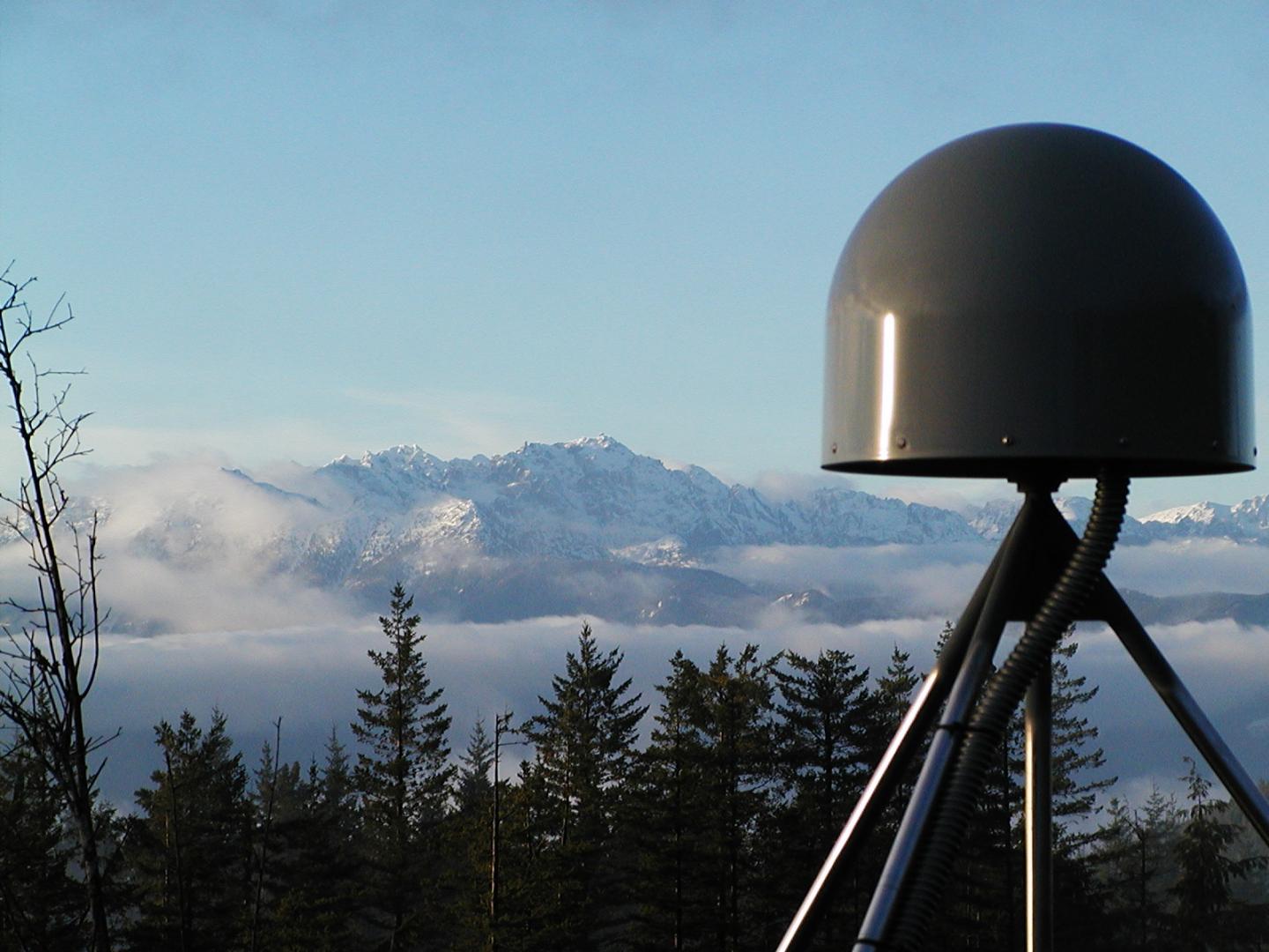
A GNSS station in the Pacific Northwest geodetic array. (Photo: Central Washington University)
Anritsu Corporation and Orolia announce immediate support of assisted GPS (A-GPS) test functionality to meet 5G New Radio (NR) Carrier Acceptance Testing (CAT) requirements for multiple North American operators on the Anritsu ME7834NR 5G mobile device test platform.
As part of the strategic partnership between the two companies, Anritsu leverages Orolia’s GNSS simulation capabilities to deliver A-GPS CAT testing platforms featuring the new Orolia GSG-SKY-ANR solution. The Anritsu MR7834NR supports A-GPS, FR1, FR2, FR1+FR2 NSA and SA US operator signaling requirements on the same platform.
The ME7834NR 5G NR mobile device test platform. (Photo: Anritsu)
The A-GPS simulation component of Anritsu’s ME7834NR-based test solution leverages Orolia’s GSG-SKY-ANR simulation platform. The GSG-SKY-ANR is powered by Orolia’s award-winning SKYDEL simulation engine, which delivers flexible, scalable, and efficient GNSS/GPS simulation solutions. The GSG-SKY-ANR GNSS simulator is exclusively available to Anritsu ME7834NR customers.
Anritsu ME7834NR A-GPS-enabled solutions for 5G NR CAT requirements are available immediately. The test solutions support the rollout of nationwide 5G networks by helping to ensure device compliance and optimum operability.
“Anritsu continues to address the needs of our customers globally,” said Shinya Ajiro, general manager of Anritsu Corporation. “By partnering with Orolia, a worldwide leader in GPS simulation technology, we are introducing a reliable, accurate, and cost-effective A-GPS CAT solution that conforms to operator requirements and delivers repeatable results. We remain committed to provide the validation tools necessary for mobile operators, device makers, chipset manufacturers, and test houses to verify designs and ensure product performance. This benefits everyone in the mobile ecosystem.”
“Orolia is proud to support North American operators through our partnership with Anritsu,” said Lisa Perdue, simulation director at Orolia. “Our resilient GPS simulation solutions deliver proven high-end capabilities for critical technology challenges such as the implementation of 5G.”
The world is moving quickly toward 5G communication networks and devices to reach better performance with exponentially higher data speeds and greater reliability. However, these systems require the right combination of hardware, signal and software compatibility to work, and operating standards vary depending on the environment and the required transmission speed.
With these variables in play, global telecom, defense, and critical infrastructure organizations are in the process of thoroughly testing the functionality of this new technology on their particular systems in the appropriate operating environment before deploying 5G.
The fifth-generation technology standard for telecommunications is here, and it is already being tested and deployed in locations worldwide. This informative webinar will provide updates on the testing and implementation of 5G infrastructures, highlighting use cases in automotive and other mission-critical applications.
Panelists will discuss key factors for the successful implementation of 5G, the testing requirements needed to ensure consistent operations, and resilient positioning, navigation and timing (PNT) technologies that can help ensure accurate, continuous operations for critical applications during interference or signal loss.
What: Orolia Presents: GPS World Webinar, “Resilient PNT for a 5G World” When: May 20 at 1 p.m. EDT Where: Online, Register here
Confirmed panelists:
Lisa Perdue, Product Line Director, Simulation, Orolia
Adva’s OSA 5405-MB provides nanosecond timing at a network’s edge. (Photo: Business Wire)
Adva has launched the OSA 5405-MB, a compact outdoor precision time protocol (PTP) grandmaster clock with multi-band GNSS receiver and integrated antenna.
Part of the OSA 5405 series of smart synchronization devices for indoor or outdoor deployment, the OSA 5405-MB ensures timing accuracy by eliminating the impact of ionospheric delay variation. This empowers communication service providers and enterprises to deliver the nanosecond precision needed for 5G fronthaul and other emerging time-sensitive applications.
The GNSS receiver and antenna enable the OSA 5405-MB to meet PRTC-B accuracy requirements (+/-40 nanosec0nds) even in challenging conditions. For the first time, the technology is available in an edge timing device with minimal footprint, helping operators achieve unprecedented accuracy and reliability as they roll out wide-spread small cell networks.
“Our multi-band, multi-constellation GNSS receiver provides an extremely cost-efficient way to achieve PRTC-B UTC-traceable network timing with the levels of accuracy needed for next-generation use cases,” said Gil Biran, general manager, Oscilloquartz, Adva. “By adding this technology to our versatile, small-form-factor OSA 5405 series, we’re offering a route to precision synchronization at the network access without significant investment.”
“A ruggedized design and minimal visibility make our OSA 5405-MB easy to install in almost any outdoor location,” Biran said. “With the power to compensate for ionospheric delay variations and resilience against jamming and spoofing, our compact edge solution really is the key to 5G synchronization.”
The OSA 5405 series is a versatile timing solution for deployment deep in urban canyons, where advanced end applications require stringent synchronization. With its small form factor, the OSA 5405-I indoor variant can be positioned on windows to avoid multipath signal interference.
Offering both electrical and optical interfaces and with cost-effective Ethernet cabling, the OSA 5405 series avoids RF feeds of traditional GNSS installations by integrating an antenna, receiver and PTP grandmaster in a single device.
Ionospheric Delays. With multi-band GNSS technology, the OSA 5405-MB also protects against timing inaccuracies caused by ionospheric disturbance. By receiving GNSS signals in two frequency bands and using the differences between them to calculate and compensate for delay variation, the OSA 5405-MB eliminates inaccuracy and ensures ultra-precise synchronization whatever the space weather conditions.
It can work with up to four GNSS constellations concurrently (GPS, Galileo, GLONASS and BeiDou), increasing the number of observable satellites in urban canyons. A comprehensive set of Syncjack PTP and GNSS jamming and spoofing monitoring features in combination with Adva’s Ensemble Controller and Sync Director assures high synchronization quality and provides transparency for simple operation of large synchronization networks.
The OSA 5405-MB also offers network-delivered timing backup to further mitigate GNSS vulnerabilities and make synchronization more robust and resilient.
Acculink Cargo provides a near real-time visibility, global tracking and exception-based monitoring asset tracking to serve the $30B+ global market.
Sierra Wireless has launched Acculink Cargo, a new managed internet of things (IoT) solution that companies can quickly deploy to track the location and condition of high-value and sensitive assets.
Delivered as a service for a single monthly fee, Acculink Cargo leverages Sierra Wireless’ expertise in IoT devices, global connectivity and the cloud to deliver a service companies can use to monitor the near real-time status of assets anywhere in the world, as they move through their supply chains.
Acculink Cargo enables electronics manufacturers, cold-chain carriers, general freight carriers, food and produce shippers and third-party logistics firms to gain the supply-chain visibility they require to avoid shipping delays, minimize dwell time, prevent theft and remediate environmental conditions that can lead to asset damage. In addition to tracking the location of these assets, Acculink Cargo can also alert customers if an asset is exposed to light, changes in temperature, humidity, shock, or other conditions that might spoil or otherwise damage it.
Drawing on more than two decades of experience in the IoT market, Sierra Wireless has designed Acculink Cargo to address the three key needs facing companies as they seek to track high-value and sensitive assets — real-time visibility, product-level tracking and exception-based monitoring.
Acculink Cargo benefits include:
Quick deployment. Acculink Cargo fully integrates edge devices, global network connectivity and a cloud-based application, supporting quick deployment in as little as 30 days with minimal startup costs.
Highly accurate tracking. Use of LTE cellular wireless networks in combination with GPS data enables customers to pinpoint the location of their assets.
Flexibility. The cloud-based application features an intuitive user interface with customizable dashboards and configurable alerts.
Configurable location and status reporting. Users can set up specific geolocation, light, temperature, humidity and shock conditions to monitor for each shipment. Users can also adjust when data on these conditions is updated, allowing them to extend the battery life of their edge devices.
Insights. Users can analyze real-time and historical shipping data to uncover trends that can help them make better business decisions.
“When it comes to high-value and sensitive assets, companies no longer want to just track their location as they travel through their supply chains. Today, they expect to be able to monitor the condition of these assets in near real-time as well,” said Rupal Nanavati, vice president and general manager of IoT applications, Sierra Wireless. “Acculink Cargo addresses these needs, with an easy-to-deploy, fully integrated managed solution from the global leader in IoT.”
Pricing. Acculink Cargo is sold on an as-a-service basis, allowing customers to easily scale the solution up or down as their business needs change. Customers can purchase devices up front, and pay for connectivity and the application on a subscription basis. Or, they can sign up for a complete managed IoT service, with a single monthly fee that covers devices, network and application access.
Acculink Cargo is currently available to customers throughout North America. Sierra Wireless plans to expand availability of the solution to other regions.
GTX Corp will begin testing its new Cat M1 LTE SmartSoles across North America, Europe and Australia, and will begin the regulatory certification process for FCC/IC and CE.
The following week will begin the device network certification with Verizon, which will be providing the cellular connectivity for the North American market. GTX will also be testing with Orange and Telefonica for connectivity in Europe and Australia.
“With over 200 back orders and increasing demand every day, we intend to begin production as soon as we complete testing and certification, expected sometime next month, and then immediately start fulfilling all pre-orders and backorders first,” said Andrew Duncan, GTX Corp. director.
The patented and award-winning GPS SmartSoles were designed to address Alzheimer’s and autism challenges, where those diagnosed are at risk of wandering and becoming lost. Wandering is a safety issue with far-reaching implications for the person with the disease, their caregiver, law enforcement and healthcare providers.
GPS SmartSoles are placed in the wearer’s shoes. They contain a Nordic Cat M1 LTE GPS module connected through cellular networks that send a GPS location to the GTX central monitoring website and app. GTX is also upgrading its tracking app both for iOS and Android.
The SmartSoles can also be used by people at risk of kidnapping, such as government employees, journalists and corporate executives. SmartSoles come in three trim-to-fit sizes for men, women, and children, are water resistant, include an inductive charging pad, and are assembled in Rhode Island.