Taking advantage of the recent release of Android API 24 and the GnssMeasurement class, developers now have access to unprocessed pseudorange measurements in certain smartphones.
GNSS Compare is basically a tool for scientists to compare their algorithms. For those who are not GNSS experts, it can also serve as a teaching tool on the subject.
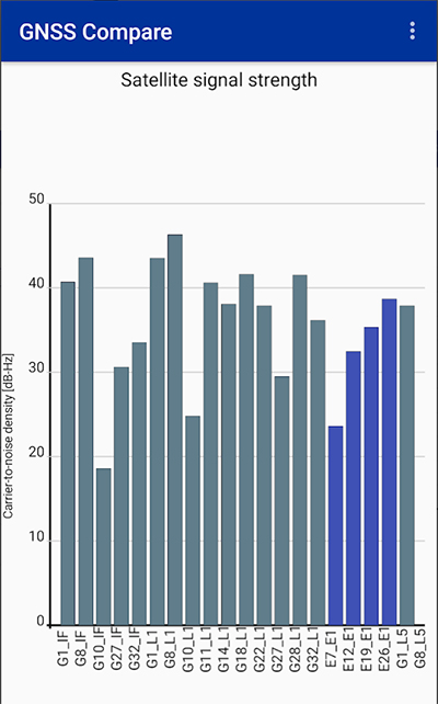
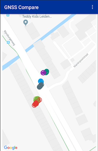
The Galileo Smartphone App Challenge was about creating a smartphone application that will allow the user to choose which satellite constellation to use for PVT estimation.
Screenshot: TFI Systems
The aim was to increase the awareness about the European Union’s Galileo satellite navigation program and also to allow users from the public to compare the performance of Galileo signals with the performance from other global satellite navigation constellations.
The app has been tested on Samsung Galaxy S8 and Xiaomi Mi 8 phones. To download, visit the store.
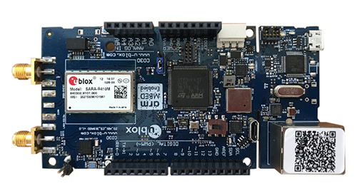
The toolset is a rapid-prototyping platform that lets product designers test and optimize the position accuracy and power consumption of wireless location tracking applications that use LTE-M and NB-IoT cellular networks, as well as GNSS technology. The toolset targets product engineers working on battery powered applications such as sport, people and asset trackers.
An increasing number of battery powered consumer and industrial products feature integrated GNSS receivers. These products include virtual reality headsets, smart watches, and devices to track elderly people, containers or parcels.
With the ongoing roll-out of low power wide-area cellular networks (LPWAN) such as LTE-M and NB-IoT technologies around the world and the extremely low power consumption they enable, the range of use cases for wireless location trackers is expected to expand further.
Screenshot: u-blox
“With today’s technology, product designers can now include optimized battery life in their applications,” said Florian Bousquet, product manager, Product Center Positioning, at u-blox.
“We developed this toolset to give customers a quick and easy way to test the accuracy and the power consumption of their product ideas using the latest generation of our technology,” he said. “In many cases, they can replicate their applications and start testing the performance of different device configurations in under 15 minutes.”
“The toolset offers access to the very latest technologies, from LTE-M and NB-IoT cellular communication to our proprietary Super-E mode(see video below) that delivers the best balance between power consumption and GNSS positioning performance,” he added.
The u-track software runs from embedded firmware on the new u-blox C030-R410M application board. The board, specifically designed to rapidly prototype applications for the internet of things (IoT), includes an ultra-small, low-power u-blox ZOE-M8B GNSS receiver and a size-optimized SARA-R410M LTE-M/NB-IoT cellular communication module.
Additionally, u-track includes a PC software application. Its user-friendly dashboard lets users log, retrieve, and visualize power consumption, accuracy, and other important values, such as the time it takes the GNSS receiver to calculate a position (time-to-first-fix, TTFF).
The u-track and C030-R410M toolset will be showcased on Sept. 12-14 at Mobile World Congress Americas, u-blox Booth no S.2702.
The solution, which will incorporate oneM2M’s current TTA-run certification program, recognizes the critical importance of mobile technologies in IoT-enabled M2M solutions — a trend that is set to accelerate with the advent of 5G.
oneM2M certification through GCF will be key to ensuring proper functionality and compliance with industry standards for fast, efficient, and secure IoT solutions in the connected world, GCF said.
Technologies which comply with oneM2M standards will ensure seamless connectivity and interoperability with back-end networks, as well as allowing for safe and secure transactions. TTA’s mission is to support global oneM2M certification services and will significantly benefit the IoT and M2M industry.
Image: GCF
“This development underlines GCF’s expertise in developing certification programmes for advanced mobile technologies in industry verticals,” said Lars Nielsen, general manager at GCF. “It complements our strategy of expansion from core telecoms technologies into IoT applications to service the emerging 5G ecosystem. GCF is collaborating with world class organisations such as oneM2M and TTA to enable the growth and proliferation of the IoT connected devices ecosystem.”
oneM2M is a global organization which creates technical specifications, common use cases and architectural principles to ensure that machine-to-machine communications can operate effectively on a worldwide scale. oneM2M architecture is based on a common M2M service layer, which can be readily embedded within vendors’ hardware and software solutions, ensuring interoperability between the myriad of IoT devices in the field and M2M application servers worldwide.
“GCF’s work with TTA highlights the growing global momentum for tested interoperability in IoT devices and applications,” said Patrick Van de Wille, marcom chair at oneM2M. “Our membership numbers are steadily increasing as organisations recognise the benefits of reducing the complexity through a global standard. All stakeholders will reap the rewards from improved productivity and reduced costs, which will ensure the sustained growth of the IoT transformation.”
TTA has been the at the fore of oneM2M certification since 2014 and is the official oneM2M testing and certification organization.
The announcement is the culmination of work TTA has carried out to expand the testing and certification service, keeping up-to-date with oneM2M standards and providing feedback on the standards by collaborating with overseas testing institutes.
“We are extremely pleased to have this partnership with GCF that supports the increasing importance of oneM2M standardisation in the global IoT market,” said Park-Jae-Moon, president of TTA. “This is a critical milestone in our journey from setting up the very first oneM2M certification solution for Korea, to meet regional needs. Now we can offer this on a global level to ensure interoperability and set a benchmark for quality that will enable a successful future for IoT connectivity.”
The tools connect directly to TomTom Maps APIs (Application Programming Interfaces) for location, tracking and mapping data services, accelerating product development, and reducing time-to-market and development costs for developers, the companies said.
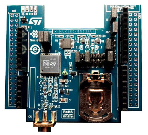
The X-NUCLEO-GNSS1A1 expansion board is based on the Teseo-LIV3F tiny GNSS module. (Photo: STMicroelectronics)
The development package consists of an STM32 Discovery host board for 2G/3G cellular-to-cloud connectivity, a GNSS expansion board based on ST’s Teseo satellite navigation technology, and a software Function Pack that connects an internet-of-things (IoT) node via a cellular network to a range of TomTom Maps APIs.
With this hardware and software package and a TomTom developer account, developers can quickly add location-based services to their IoT and smart city applications.
Among these services are the translation of GPS coordinates into a street address inside a map (Reverse Geocoding), retrieval of nearby point of interests, and the production of accurate navigation directions.
“We have combined TomTom’s industry-leading location-based and mapmaking technologies with ST’s unrivaled combination of silicon and system expertise to create a unique offering that provides easy access to TomTom’s Maps APIs to empower developers to create groundbreaking, location-aware applications faster and more efficiently,” said Anders Truelsen, managing director of TomTom’s Enterprise Business Unit.
“Supporting our efforts to facilitate location-based product development, our collaboration with TomTom has built on each company’s strengths to assemble a tailored package of hardware and software tools that is already fully integrated with TomTom cloud services, around the popular STM32 development ecosystem,” said Alessandro Cremonesi, group vice president at STMicroelectronics. “These tools enable native STM32-based location services to accelerate application development of Geo-IoT solutions for fleet management, item tracking, and many other services that depend on fast, accurate location detection.”
In addition to the STM32 family of Arm Cortex-M core microcontrollers, the development tools leverage ST’s market-proven multi-constellation Teseo positioning-receiver technology to perform all positioning operations including tracking, acquisition, navigation and data output.
With 106 operational GNSS satellites flying today (or was that yesterday’s number?) satnav’s backbone is robust, variegated, supportive of growth across many industries — and poised to leverage even more prosperity. I’ve seen forecasts of as many as 400 satellites, well beyond GNSS proper and involving low-Earth orbit telcomm constellations, constantly patrolling space above us and beaming down positioning, navigation and timing (PNT) intelligence.
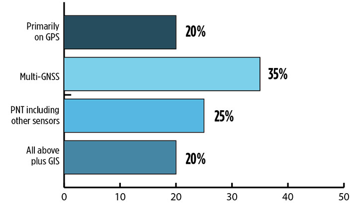
Where do you see your efforts focusing primarilly over the next decade? (Source: GPS World’s 2018 State of the Industry survey)
A draft headline for the cover of this issue — The Sky’s the Limit! — actually underestimated. Not even the sky is the limit.
Mobile. GNSS-enabled tablets and smartphones provide navigation, traffic and congestion maps to billions. These features will continue to drive demand for GNSS in all electronic equipment. As we move from the internet to the internet of things (IoT) as the dominant paradigm of advanced and developing societies, GNSS will boom louder than we have heretofore known it to do.
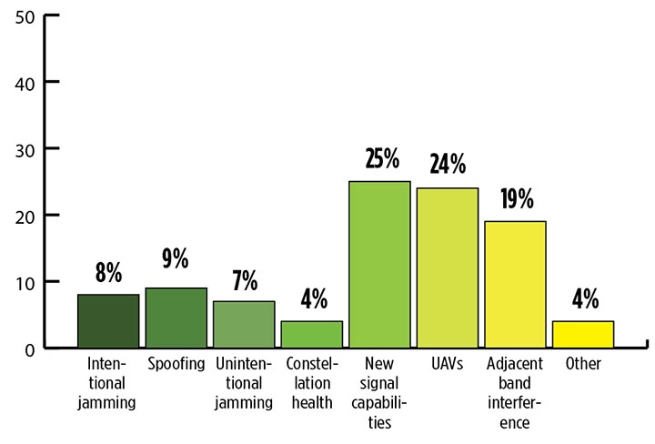
What is the industry “Issue of the Year?” (Source: GPS World’s 2018 State of the Industry survey)
Communication and location-enabled transportation services such as Lyft and Uber provide only one example of novel GNSS uses that have become the norm.
Tracking devices, whether personal, vehicular, or affixed to large assets, constitute a quiet though muscular growth market. The GPS tracking device generates high demand from industries such as information technology (IT), transportation, and telecommunication, providing real-time intelligence and advance diagnoses about products, vehicles and people, valued by consumers and businesses, enhancing security and safety — key concerns that will only grow in an increasingly vulnerable world.
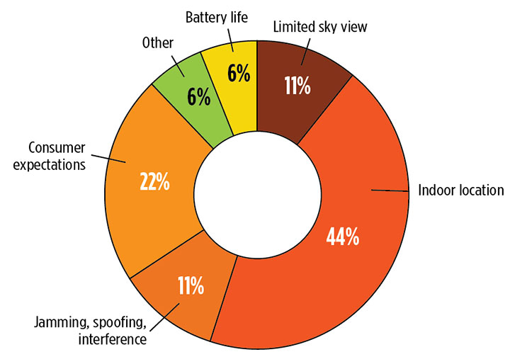
What is the key challenge for positioning and navigation in the wireless and consumer space? (Source: GPS World’s 2018 State of the Industry survey)
Volume! The GPS tracking segment alone is expected to reach $2.53 billion by 2023, nearly 12% annual growth. Other mobile segments will increase in parallel. Don’t be deceived by the low-cost of low-accuracy tracking devices. Volume! Volume! Volume! is just as powerful a mantra as Location! Location! Location!
With the wireless carriers and IoT behind it, GNSS will see growth a-plenty and virtually no downside. U.S. cell carriers are now selling access to your real-time phone location data, a key signal that economic giants put high value on the technology.
For more results from the 2018 State of the GNSS Industry, see this page.
Sports data company STATSports is offering STATS GPS shirts to provide real-time GPS intelligence to athletes and coaches.
Wearing STATS GPS shirts, teams can monitor player metrics such as accelerations/decelerations, energy expenditure and count of zone entries, as well as time, distance and power thresholds.
The system uses a 50-Hz sampling frequency. It allows practitioners to monitor up to 100 players in real time and post session with more than 300 GPS, inertial measurement unit (IMU) and HR-derived metrics, the company said.
The shirts feature an embedded medical-grade ECG sensor that’s fully integrated with the GPS units, allowing for seamless real-time analysis with the STATS Dynamix online portal.
Customizable reports can include information on imbalance, cardiovascular metrics and running, explosive and brake symmetry.
The SensLynx GPS Management Accelerator Program (GMAP) can enable start-ups or enhance existing business portfolios with the addition of tracking solutions, the company said.
GMAP requires no upfront investment or inventory warehousing, and is structured to deliver recurring revenue via new sales channels, while also being compatible with legacy business models to capitalize on similar customer profiles.
Because SensLynx white labels its solutions under certain criteria, entrepreneurs earn significant margin on hardware sales, plus monthly subscription income from the customers they will own outright.
“We believe in the entrepreneurial spirit,” said Rob Garry, co-founder and CEO of SensLynx. “Not only does this Accelerator Program help us grow our IoT Fleet sector on a grass roots level, it inspires others to strike out on their own or expand.”
The GMAP program is built around SensLynx’s bundled solution components, which include Fleet & Asset Tracking, Electronic Logging Device, Routing Application, Video/DashCam capture and Workforce Management for smartphones.
At its heart is comprehensive fleet/asset tracking software, packed with features like data handling, parsing, database, mapping, alerting, reporting, dispatch, maintenance logging, e-logs, local posted speed limits, addressing, geofencing, interstate miles, open API-based software and more.
The complete bundled solution with software, hardware and data connectivity is packaged at one guaranteed monthly price.
Senslynx’s GMAP program includes initial training, planning for rollout, conducting telemarketing for launch, developing website content, providing custom-branded marketing materials and online demo support, accessible through the streamlined GMAP Reseller Portal where businesses can also easily manage supply chain and customer accounts.
Recent changes in hardware and standards make one-meter accuracy possible, in some cases as soon as this year. The transcript of a talk given to Android developers earlier this year, this article gives a short overview of location in smartphones, introduces Wi-Fi round-trip time technology and standards, and then explains the Wi-Fi application programming interfaces.
ByFrank van Diggelen, Roy Want and Wei Wang, Android Location, Google
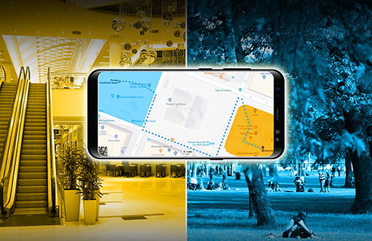
Image: GPS World; outdoor, Andriy Solovyov/Shutterstock.com; indoor, Rade Kovac/Shutterstock.com
It’s a great time for location applications because technology hardware standards and Android application programming interfaces (APIs) are all evolving simultaneously to enable an improved location accuracy that has not previously been possible when using smartphones.
Eventually, this means high accuracy for everyone, but we want to take you under the hood of location because we want to give you the opportunity to get a head start on the future. We also want to highlight the need to protect and respect the user. The more people who use location, the more careful we and you have to be. We will highlight where you must get user permissions and we’ll close with some guidelines for making great location apps.
Where are we today with indoor location accuracy? If you’ve noticed that your phone seems to be more accurate when you’re inside shopping malls and office blocks than it was a few years ago, you’re not imagining it. With each release of the fused location provider, we have had steady improvement of the Android algorithms and machine learning for Wi-Fi locations.
There continues to be improvement, and you’ll see indoor accuracy of better than 10 meters, but round-trip time (RTT) is the technology that will take us to the one-meter level.
Meanwhile, what about GPS? In terms of GPS accuracy in the open sky, there has not been much change in the last few years. If you’re outside and can see the open sky, the GPS accuracy from your phone is about five meters, and that’s been constant for a while. But with raw GNSS measurements from the phones, this can now improve, and with changes in satellite and receiver hardware, the improvements can be dramatic.
Everyone’s familiar with the blue dot, but to get the blue dot you need a location provider, and to get location you need measurements — specifically, range measurements from Wi-Fi access points or from GPS satellites. We’ll show you how one-meter measurement accuracy can be made available in smartphones. The key technologies are Wi-Fi RTT, GPS dual-frequency and carrier phase measurements.
If you want to wait a year or two, this will find its way into the worldwide ecosystem and the Android fused location provider API, but we want to give you a chance for a one- to two-year lead by taking accurate measurements and turning them into accurate location. We want to work with you to accelerate development and bring the present closer to the future.
You might wonder, why do I need better location accuracy anyway? Let’s look at two instances where existing apps could use much better location accuracy.
For indoor routing or navigation of the kind that you’re used to in your cars, you need much better accuracy than you have outdoors: you need one-meter accuracy, because indoor features like cubes or aisles are only a few meters wide. Even for the most loved outdoor applications such as map directions and finding alternate routes in traffic, we could benefit from higher accuracy than we have now.
For example, when you came here this morning in a car, you probably had your arrival time estimated using the average speed of the traffic. What you really want is the traffic speed in the lane that you’re in, so that you could ask, how much faster would it be if I took the carpool lane instead? There are, of course, many other use cases and we’ll mention a few. But the important thing is that we are sure that you will have many more ideas than we have, and that’s the beauty of the open Android ecosystem.
Wi-Fi Round-Trip Time
Wi-Fi RTT ranging and indoor position estimation is based on making measurements of the time of flight of RF signals, and can be used to estimate your indoor position to an accuracy of one to two meters.
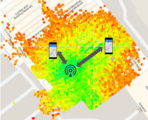
Before we get into the details of Wi-Fi RTT, we want to tell you how we currently calculate an indoor location. At this time, we use Wi-Fi received signal strength indication (RSSI). Basically, we can calculate distance as a function of signal strength. Figure 1, with the access point in the center, shows a heat map of the signal strength around a Wi-Fi access point (AP).
Figure 1. Wi-Fi receive signal strength indication (RSSI) non-isotropic signal propagation. (Image: Frank van Diggelen, Roy Want and Wei Wang)Figure 2. Wi-Fi RTT principles, basic concept.(Image: Frank van Diggelen, Roy Want and Wei Wang)Figure 3. Wi-Fi RTT principles in practice. (Image: authors)
The green is the strongest signal, near the AP and the red is the weakest, measured toward the edges. I’ve placed two phones on this diagram at the transition between the weak and the strong. Notice that the phone on the right is further away from the access point than the phone on the left. The signal strength can therefore vary at the same distance, which unfortunately makes it very hard to make accurate range measurements based on this type of measurement. There are lots of algorithms and tricks that can be used to improve this, but the greatest improvement can be achieved using a new Wi-Fi technology.
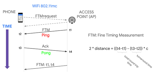
That’s where Wi-Fi RTT comes into play. It uses time-of-flight instead of signal strength. It measures the time it takes to send a Wi-Fi RF packet from an access point to a phone and back again. Because radio signals travel at the same speed as visible light, if we multiply the total round-trip time of a Wi-Fi packet by the speed of light and divide by two, we get distance, and therefore the range from the phone to the access point. That’s the basic principle.
If you want to use several ranges to nearby access points to calculate your position, we have to use a process called multi-lateration. The key thing to think about here is that the more ranges you have, the more accurate the position you can estimate. If you can use at least four ranges, then we think you can achieve a location accuracy of about one to two meters in most buildings.
Why are we telling you about Wi-Fi RTT today? Why not last year or before? Because 2018 is the year of Wi-Fi RTT in Android. We are releasing a public API in Android P based on the IEEE 802.11mc ranging protocol. Furthermore, we’re also integrating aspects of this protocol into the fused location provider, which is the main location API that developers use to put a blue dot on a map. So, in the near future, any time there are RTT access points in the vicinity of a phone, the estimated position accuracy will be greater.
History. The 802.11 standard was ratified in December 2016, and in early 2017 the Wi-Fi Alliance started an interop program for silicon vendors to make sure the chips followed the protocol. That’s when we started doing a lot of work to validate its operation and understand how it could be integrated into Android. By the fall of this year, we will release the public API so that you can all have access to this capability and can build your own applications around the technology.
Principles of Wi-Fi RTT Operation
The ranging process starts with a standard Wi-Fi scan. The phone discovers the access points that are nearby, and, based on certain bits in information elements (IEs) contained in the Wi-Fi beacons and the probe responses, we can figure out which of those access points are RTT-capable, and the phone can choose one of them to range to. It starts by making a request to the access point; as a result, the access point will start a ping-pong protocol in response. The ping sent to the phone is called a fine timing measurement (FTM) packet, and the pong sent back to the access point is an acknowledgment of that packet.
The arrival and departure time stamps are recorded at each end of the transaction, but for the phone to calculate the total round-trip time, it needs to have all four of those times. So the access point sends one more packet to the phone, and this third message contains the missing times. The phone then simply calculates the round-trip time by subtracting the time stamps from the AP, and subtracting its own packet turnaround timestamps. The difference between these times leaves just the packet time-of-flight. We multiply this by the speed of light to get distance, and divide by two to get the range that we are trying to measure.
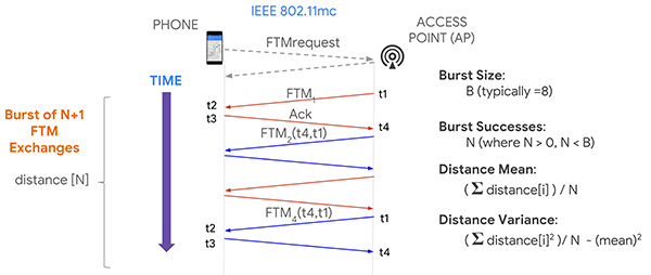
Now, it turns out if you execute this process multiple times, you will in fact get more accuracy, and so that’s what the protocol allows for, enabling a burst of FTM packets. We’re typically doing a burst of about eight of these of these transactions and, as a consequence, the system can calculate ranging statistics, such as the mean and the variance. This allows us to more accurately plot a position on a map, and knowing the accuracy also allows us to more easily calculate a trajectory.
Now that you have ranges, how do you get a position? One way, similar to GPS positioning, is you take four ranges to four separate access points; if those ranges were accurate, they would define four circles that would intersect at a single point. In practice, because of error in each range, a maximum likelihood position is calculated using a least squares multilateration algorithm.
You can then further refine this position by repeating the process, particularly as the phone moves, and then calculate trajectory using filtering techniques, such as Kalman filtering, to optimize the estimate.
Like any new technology, there are challenges, and we’ve experienced some of these early on. What we find is that sometimes there is a constant range calibration offset that may be as much as half a meter. Sometimes you also see multipath effects where a packet on the non-line-of-sight path from the access point to the phone is received rather than on the line-of-sight path, making the range appear longer. That problem can be solved by the vendor using something called antenna diversity, but all of these issues are related to algorithms, which the vendors are improving.
Basically, we need to go through a sort of teething process to get rid of these bugs, and Google can help in this process by providing reference platforms and reference applications. Vendors can then calibrate their own platforms before you guys even get to use them, which will be the ideal situation.
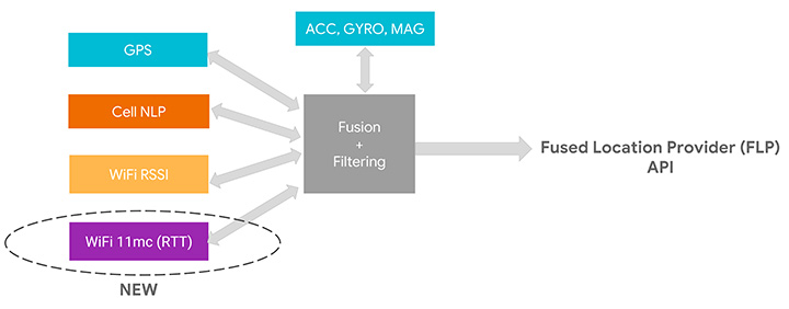
We’ve assumed that as early adopters you want to start using this API, but as we move into the relatively near future, we expect you to just use the Fused Location Provider because we’re going to be integrating the RTT capability into it. At the moment, the Fused Location Provider uses GPS (when it’s available), cell-tower signal strength and Wi-Fi RSSI, and fuses all this with the onboard sensors: inertial navigation from the accelerometer, gyro and compass. Now we’re adding Wi-Fi RTT into that mix, and it will increase the accuracy of the Fused Location Provider whenever RTT-capable access points are available nearby.
One other thing to remember is that if you are calculating the Wi-Fi RTT position yourself, you also had to know the position of the access points. In the Fused Location Provider, we will calculate those positions for you automatically: we’ll crowd-source those positions so you won’t have to worry about that, and it will make life a lot easier for you to write applications.
RTT APIs
Let’s walk you through the RTT APIs in P to see how you can add RTT in your own application. As we mentioned, RTT measures the round-trip time between two Wi-Fi devices so both your mobile phone and your access points need to support the 802.11mc protocol. As you saw, RTT can give you very fine location estimates down to one-meter accuracy, so your application needs to declare the ACCESS_FINE_LOCATION permission. Of course, both location and Wi-Fi scanning need to be enabled on the mobile device.
How do you know whether your mobile phone supports RTT? In P, we added a new system feature called FEATURE_WIFI_RTT so you can simply check whether this returns true on your mobile device. Our pixel phones running P DP2, and above, will support RTT. How do you know whether your access points support RTT? As usual, you will need to do a Wi-Fi scan and get a list of Wi-Fi scan results. Then iterate through the scan results and check for each scan result whether the method is80211mcRepsonder() returns true. This will tell you whether the access points support RTT.
After you get a list of RTT-enabled APs, simply add them to the ScanRequest Builder to build a scan request. RTT is carried out by the WiFiRTTManager, which you can get access to by getting the system service WIFI_RTT_RANGING_SERVICE. Now we’re ready to start RTT ranging by sending the RTT request to the RTTManager with a ranging result callback. Usually RTT takes only a few hundreds of milliseconds, and when it finishes, you will get a list of information including the status — an RTT may fail, the MAC address — which AP you have just ranged, and most importantly, the distance between the mobile phone and the access point.
Here is the list of information you can get from RTT ranging results: the distance, the distance standard deviation, which is the standard deviation from multiple ranges in multiple FTMs, and the number of attempted FTM measurements and number of successful measurements. The ratio of successful measurements over attempted measurements will give you an idea of how good the Wi-Fi environment is for RTT ranging.
We mentioned all Pixel devices support RTT. How about access points? We are beginning to see access points supporting the 11mc protocol in production. We are also very excited to let you know Google Wi-Fi will soon support the 11mc protocol. By the end of this year, off-the-shelf Google Wi-Fi will have RTT enabled by default. Worldwide, we’re also beginning to see the deployment of RTT APs. South Korea is actually leading the deployment of RTT APs.
Of course, this is just the beginning of the long journey. We’re very eager to see a larger penetration rate of RTT APs in the coming years.
Figure 4. Integrating RTT with Android location.(Image: Frank van Diggelen, Roy Want and Wei Wang)
GPS and the Great Outdoors
Carrier-phase precision has been in commercial GPS receivers since the 1980s. What is new is the availability of these carrier-phase measurements from phones and dual-frequency measurements in phones. Right now, all of your smart phones, all smart phones everywhere, have GPS or GNSS on one frequency band only. It’s known as L1. But there’s a new frequency in town called L5, and it’s supported by all these GNSS systems: GPS, Galileo, BeiDou QZSS and IRNSS. The availability of a second frequency means that you get much faster convergence to carrier-phase accuracy.
What about hardware? In the last few months, several companies that produce consumer GPS chips have announced the availability of dual-frequency L1/L5 GPS chips both for the automobile market and for the phone market. These chips are now being designed into cars and phones.
Let’s talk about the measurements themselves and the APIs. The phone must support the GNSS measurements API. Your app is going to need the ACCESS_FINE_LOCATION permission, and location needs to be on.
How do you know if a particular phone supports these measurements? At a high level, you can just go to a website that we maintain, g.co/GNSSTools, as part of the Android developer site. A table there lists phones that support the GNSS measurements and also which characteristics they support. It’ll tell you which phones support the measurements and which of those support the carrier-phase measurements.
Programmatically, you do this as follows: You call the method onStatusChanged and it will return an integer that tells you the capability of the phone, either if the phone just does not support the measurements at all or if it supports it but location is off, or if it supports it and location is on; in that case, you’re good to go.
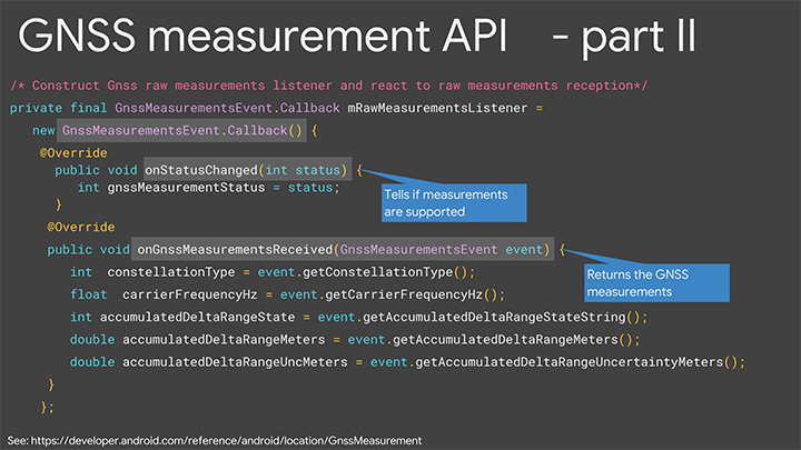
Let’s get into some details of the APIs. The most relevant methods for what we’re talking about here are the following three:
getConstellationType() tells you which of the different GNSS constellations a particular satellite belongs to.
getCarrierFrequencyHz() tells you whether you’re on the L1 or the L5 band for a particular signal.
Most importantly,
getAccumulatedDeltaRangeMeters() tells how far along that carrier wave the receiver has tracked you since it began tracking the signal.
There’s something else that we need to explain, which is duty cycling. Right now when you’re navigating with your phone and you see the blue dot moving along, you might think that the GPS is on continuously. It’s actually not. What’s happening in the phone is that GPS will, by default, be on for a fraction of a second and then off for the remaining fraction of a second, and then repeat. This is to save battery. You perceive that the GPS is on all the time because the blue dot will move along continually, but actually it’s duty cycling internally.
For this carrier-phase processing, you have to continually track the carrier wave because the carrier wave is like a finely graduated ruler or tape measure with no numbers on it. So if the GPS was on and your receiver measured your phase and you get the data from the reference station, you’d start processing. If the GPS then goes off for a fraction of a second, you’ve lost where you were. It’ll start again, you’ll reacquire, you’ll be at a different phase on the reacquisition, you’ll start again — well, you’ll never solve the problem. You need the tape measure to stay out and you need to process, and to do that you need to disable duty cycling. You can do that in Android P with a developer option.
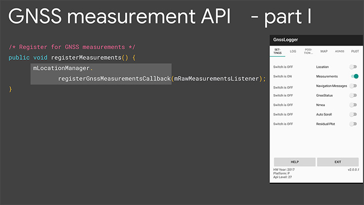
Details of the API. Figures 5 and 6 are screenshots of an application that we’ve put out called GNSS Logger. This enables you to log the raw measurements in the phone. The nice thing about this app is it’s a reference app: the code is open source and available to you on Github, so when you build your app, please make use of our code.
Figure 5. Screenshot of GNSS Logger. (Image: Frank van Diggelen, Roy Want and Wei Wang)Figure 6. Sample code for getting GNSS raw measurements. (Image: Frank van Diggelen, Roy Want and Wei Wang)
When you build an app that needs raw measurement, you will need the Android location manager API with the method registerGnssMeasurementsCallback. This method requires you to pass it a GnssMeasurementsEvent callback shown here. You construct this callback, and then override the method onStatusChanged, and that will give you the integer status that we discussed to tell you if measurements are supported.
If they are, you then override the method onGnssMeasurementsReceived, and this allows you to receive a GnssMeasurementEvent every epoch, for example, every second. This event gives you the values we’ve been talking about: constellation type, carrier frequency and accumulated Delta range. For duty cycling, that’s a developer option, so you access that through the developer page on your phone as you see there on P. This allows you to disable the duty cycling.
Keep in mind this introduces a trade-off between getting the continuous measurements and battery life. There will be an impact on battery life. How much? Well even when GPS is on continually, it will use less than 20% of the power that screen-on uses, so that gives you a feel for the magnitude. This is a developer option precisely because it’s a trade-off involving battery life, and we’re very concerned about maximizing battery life, but if you and our team together can prove that there’s value in this option and people want it, then it will be upgraded to a fully supported API in the future.
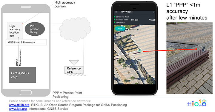
Figure 7 shows the basic architecture that we expect if you implement an app for high accuracy. On the bottom of the block diagram on the left you’ve got the GPS/GNSS chip. The GNSS measurements come up through the APIs we’ve just described, and then your app lives at the top in the application layer. You’re going to need access to a reference network to get the data that the reference stations are tracking. There are publicly available reference networks. I’ve listed one at the bottom: the International GNSS Service. You can get data from them free.
Figure 7. Apps for high-accuracy GPS.(Image: Frank van Diggelen, Roy Want and Wei Wang)
Then you need to process that data in some kind of position library, and that does all the carrier-phase processing, and that too is available as open-source code. RTKLib.com has an open-source package for precise positioning. Then you’re good to go.
We mentioned that dual frequency gives you much faster convergence to the high accuracy, but you don’t have to wait until the dual-frequency phones come out. You can start doing this with single-frequency phones. Here’s an example of someone who’s already done that. This is an app created by the French Space Agency, and they’re doing exactly what we show on the block diagram on the left and they’re achieving sub-meter accuracy after a few minutes of convergence.
Here’s some more external analysis that’s been done in a similar way. This is from a paper called “Positioning with Android GNSS.” This is using one of those chips that we showed you, the chip that goes in cell phones that does dual frequency. What’s been shown here is the cumulative results over many different starts of the GPS and what you see is that most of the time the accuracy is better than a meter. You see that on the vertical axis, which is 0 to 1 meters, the accuracy gets to better than a meter in less than one minute and then continues to converge as long as the phone continues to track that carrier phase continuously.
Here’s a another similar but different paper. This is using one of the chips that’s meant for cars. This was tested in a car driving around that track there, and what the plot here shows is the accuracy after the initial convergence while the car was driving. You see with GNSS alone the accuracy is 1 to 2 meters, and with this carrier-phase processing it’s at a couple of decimeters.
For you to build this, what are you going to need? Of course you need the device location to be enabled and your app has to have location permissions, so that’s going to come from the user. You need the basic GNSS measurements, that’s been available since Android N. You also need this continuous carrier phase I’ve been talking about and that’s available in P with the developer option. It would be nice to have dual frequency for fast convergence and that’s coming soon. You need a reference network such as the one we already mentioned; there are also commercial reference networks out there and commercially available software to do the same thing, but we recommend you start with the free stuff and go from there.
Finally there’s the app from you.
In summary, everything we’ve been showing you here is based on indoor and outdoor technology that’s been evolving kind of in parallel. In each case we have a new technology and Android P gives you a way to access it.
Indoors Again
The new technology is Wi-Fi RTT and round-trip time-enabled access points. We give you a public API to access these measurements, but you need access point infrastructure. This is where some of you can move ahead this year, because if you have a customer who owns or controls a venue, they can upgrade their access points — sometimes just a firmware upgrade — and then you have the infrastructure. Android P comes out later this year, and you can implement something and have indoor navigation, or create any other type of context-aware app.
For example, someone goes in a store: where’s the milk? You can make the world a better place for all of us by saving us from the tyranny of having to ask directions from strangers. And if you’re not one of those people who has access to this now, in a few years the infrastructure will naturally evolve as access points upgrade to RTT, and one-meter location will be automatically available from the Fused Location Provider.
Now Outdoors
For this carrier-phase process, it’s not just outdoors, but outdoors with open sky. What do you need? Dual frequency and continuous carrier phase. We give you the API and the developer option to make use of that. You will need reference-station access as we mentioned, and then applications.
What can you do outdoors with open sky? We already mentioned the traffic example. There are many others that readily come to mind where existing GPS accuracy doesn’t cut it. For example geocaching, where people look for treasures; it would be nice to have one-meter accuracy. Precision sports monitoring. Imagine a snowboarder who wants to measure her tracks very precisely after the fact. Five-meter location is not good enough. One meter would be great.
Speaking of sports, there are more and more drone apps where you have a kind of “follow me” capability, and the drone will fly along and video you. Well it would be nice if it videos you and not the person next to you. And so on. There are hundreds of apps, and you’re probably thinking of some right now, and that’s the whole point.
We want you to write those apps, and together we’ll bend the arc of technology history closer to the present. I’m really looking forward to next year to see you back here and see what you’ve created.
Finally, we want to leave you with a couple of pointers. When you build location apps, please build great location apps. You must have user trust. Please provide the user with transparency and control. You’re going to have to ask for location permissions for this. Explain to them what you’re doing, how it benefits them. When things go wrong, make your app recover gracefully. If these measurements are unavailable for some moment or something goes wrong, you can fall back to the Fused Location Provider location.
Think about that and, finally, respect the battery life trade-offs that we’ve discussed.
FRANK VAN DIGGELEN is a principal engineer in the Android location team, leading high-accuracy location including Wi-Fi and GPS. He holds more than 90 U.S. patents on GPS, and is the author of A-GPS, a textbook on Assisted-GPS. He has a Ph.D. from Cambridge University and teaches a GPS class at Stanford.
ROY WANT received his doctorate in computer science from Cambridge University and is a research scientist at Google. His interests include mobile and ubiquitous computing. He is an IEEE Fellow and secretary for IEEE Task Group 802.11az (Next-Generation Positioning). To date, he holds 100+ issued patents in this area.
WEI WANG s a software engineer in the Android location and context team. He works on the Fused Location Provider API. His main focus is reducing battery consumption of location, as well increasing location accuracy. He received a master’s degree in information security from Carnegie Mellon University and a master’s degree from Southeast University in China.
Featured image: Frank van Diggelen, Roy Want and Wei Wang
TerraGo, a provider of mobile workforce collaboration solutions, has launched a new version of its TerraGo Streetlights platform, which is designed specifically for smart streetlight projects and includes several field-tested, customer-driven and customizable features that help accelerate savings and lower full life cycle support costs.
According to TerraGo, Streetlights is fully-integrated with Itron’s leading smart city management software, Streetlight.Vision, and is being utilized on a number of high-profile smart streetlight projects in locations around the world, including Chicago.
The platform’s latest features, which are all configurable and customizable with zero-code, include automated node commissioning with Itron’s Streetlight.Vision, full inventory chain-of-custody management, MAC address validation, integrated GPS location and proximity detection, advanced mobile app search, custom map symbology, installation status maps and reports, automated workflow updates, crew assignments, task notifications, one-click workflows, configurable asset cards, customizable operational reporting-as-a-service and more.
According to TerraGo, smart streetlights provide a measurable return on investment to cities by helping them achieve massive reductions in energy costs, carbon dioxide emissions and maintenance expenses — all while laying the open network foundation for smart city applications like traffic management, air quality, noise management and crime prevention. TerraGo Streetlights helps cities and utilities complete projects and really savings sooner, thus increasing the total return on investment while enabling future smart city applications, the company added.
“TerraGo Streetlights’ features are customer-driven from lessons learned on real-life projects, so we can improve efficiency in every phase from planning and inventory to installation and maintenance,” said Dave Basil, president and CEO of TerraGo. “We believe in being super-focused on our customers’ work, so we can deliver software that makes a real impact for these projects. We even embed our software architects and UX designers with work crews in the field, so we can learn firsthand how to minimize task times, prevent errors and get the job done right the first time.”
Ceva has launched the successor to its Ceva-Dragonfly NB1 solution targeting the NB-internet of things (IoT) market, the Ceva-Dragonfly NB2.
The Dragonfly NB2 is a highly integrated and modular solution optimized for Cat-NB2 (3GPP Release 14 eNB-IoT) that can seamlessly be incorporated into chips and modules by the multitude of companies looking to address the large and fast-growing cellular IoT space.
GNSS hardware package. For customers developing NB-IoT products that also require GNSS capabilities, Ceva-Dragonfly NB2 includes a new power-optimized GNSS hardware package, with GNSS RF receiver and multi-constellation digital front-end.
The GNSS package speeds up both acquisition and tracking tasks by up to 8 times compared to Ceva-Dragonfly NB1, enabling a host of popular NB-IoT use cases, including people, livestock and asset tracking, and geo-fencing, the company said.
IoT boom forecast. In the latest edition of the Ericsson Mobility Report, the forecast for cellular IoT increased significantly, almost doubling to 3.5 billion connections for 2023. The report cites large-scale deployments in China and increasing interest in eNB-IoT and Cat-M1 cellular IoT standards as the catalysts for 30 percent CAGR between 2017 and 2023.
Ceva-Dragonfly NB2 is a licensable Rel14 compliant eNB-IoT solution and builds on the success of Ceva-Dragonfly NB1, which has been widely licensed for a range of use cases and emerging end markets, including smart cities, transport and logistics and consumer electronics. It is centered on the Ceva-X1 DSP/control processor featuring an enhanced Instruction Set Architecture and provides a unified processor environment for both physical layer and protocol stack workloads.
The solution also includes a highly integrated, worldwide enabled RF transceiver, a power amplifier (PA) and all the associated hardware and software modules required to develop a complete eNB-IoT product, ensuring the lowest possible bill-of-materials (BOM) in the process.
In addition to the performance improvements enabled by Release 14 including higher data rates and lower latency, Ceva-Dragonfly NB2 features a range of enhancements to ensure higher performance, added functionality and increased security for NB-IoT applications compared to its predecessor.
A new power management solution, complete with intelligent sleep mechanisms ensures ultra-low sleep power consumption of a few microAmps, further improving the battery life critical to every NB-IoT device.
The enhanced RF design is already silicon-proven at 55nm and 40nm processes, further lowering the entry barriers for customers with no previous cellular expertise to enter this burgeoning market.
Ceva-Dragonfly NB2 also includes the fully optimized physical layer and protocol stack firmware designed for Release 14 Cat-NB2. The addition of an on-chip embedded flash memory and controller now allows full NB-IoT design on a single die which further reduces BOM and power consumption.
Voice trigger. Ceva-Dragonfly NB2 also supports use cases requiring always-listening voice trigger, voice commands and sound sensing. The flexibility of the Ceva-X1 IoT processor allows for these sensing features to be implemented in software. The Ceva ClearVox voice front-end software package, for example, can be used to ensure clear and intelligible voice pickup for use cases such as emergency calls and voice panic buttons. In terms of security, Ceva-Dragonfly NB2 integrates a completely redesigned secure platform, including smart interfaces to connect USIM or eSIM. Ceva also offers other complementary technologies addressing massive IoT, such as Bluetooth 5 dual-mode and low energy and Wi-Fi 802.11n/ac/ax, for short range connectivity which customers can leverage for their product designs.
“The widespread commercial deployment of NB-IoT is well underway across the globe and we’re proud to be at the forefront of technology innovation for long-range massive IoT,” said Michael Boukaya, vice president and general manager of the wireless business unit at Ceva. “With the introduction of Ceva-Dragonfly NB2, we have built on the considerable success we achieved with our first generation solution, and delivered a unique, silicon-proven eNB-IoT Release 14 solution for our customers that is unprecedented in terms of system completeness, performance and power efficiency.
“Moreover, the option of power-optimized GNSS, voice and sensing capabilities vastly increases the breadth of use cases our customers can address with this licensable solution,” Boukaya said. “There is no other IP company in the world today that can come close to offering such a complete solution for eNB-IoT and we’re excited to closely partner with our customers to create a whole new wave of applications and devices for the infinite Internet of Things.”
Ceva-Dragonfly NB2 is available for licensing now. Development kits and reference silicon will be available in the third quarter of this year.
The U.S. Supreme Court ruled June 22 that the government needs a warrant to access a person’s cellphone location history.
In the case Carpenter v. United States, the American Civil Liberties Union represented a man who had months of his cellphone location information turned over to law enforcement without a warrant. Investigators received the cell tower records with a court order that requires a lower standard than the “probable cause” needed to obtain a warrant.
The court found in a 5-to-4 decision that obtaining such information is a search under the Fourth Amendment and that a warrant from a judge based on probable cause is required.
“This is a groundbreaking victory for Americans’ privacy rights in the digital age,” said ACLU attorney Nathan Freed Wessler, who argued the case before the court last November. “The Supreme Court has given privacy law an update that it has badly needed for many years, finally bringing it in line with the realities of modern life.
“The government can no longer claim that the mere act of using technology eliminates the Fourth Amendment’s protections. Today’s decision rightly recognizes the need to protect the highly sensitive location data from our cell phones, but it also provides a path forward for safeguarding other sensitive digital information in future cases — from our emails, smart home appliances, and technology that is yet to be invented.”
Case background
In 2011, without getting a probable cause warrant, the government obtained from cell service companies months’ worth of phone location records for suspects in a robbery investigation in Detroit. For one suspect, Timothy Carpenter, the records covered 127 days and revealed 12,898 separate points of location data. Police seek these kinds of cellphone location records from phone companies tens of thousands of times each year.
After Carpenter was convicted at trial, based in part on the cellphone location evidence, he appealed to the Sixth Circuit Court of Appeals, which ruled 2–1 that no warrant is required under the Fourth Amendment.
The Supreme Court said in its opinion today, “We decline to grant the state unrestricted access to a wireless carrier’s database of physical location information. In light of the deeply revealing nature of CSLI, its depth, breadth and comprehensive reach, and the inescapable and automatic nature of its collection, the fact that such information is gathered by a third party does not make it any less deserving of Fourth Amendment protection. The government’s acquisition of the cell-site records here was a search under that amendment.”
Tech companies and media weigh in
Among the many friend-of-the-court briefs filed in the case is the one from technology companies, which was signed by Google, Facebook, Apple, Verizon, Twitter, Cisco, Microsoft and others. They echoed the ACLU’s arguments, writing that “Fourth Amendment doctrine must adapt to the changing realities of the digital era” and that “Rigid analog-era rules should yield to consideration of reasonable expectations of privacy in the digital age.”
In another friend-of-the-court brief, the Reporters Committee for Freedom of the Press and 19 other media organizations warned of the chilling effect on First Amendment freedoms that can result from easy law enforcement access to the location information of reporters and their sources.
Third-party doctrine
The government’s argument was based on the “third-party doctrine,” which the government reads to provide that by sharing information or records with a “third party” such as a business, a person gives up any reasonable expectation that the information will remain private. The doctrine was established in Supreme Court cases from the 1970s, which reasoned that without an expectation of privacy, there is no Fourth Amendment protection for certain records voluntarily shared with businesses, such as canceled checks sent to a bank or phone numbers dialed on a phone and transmitted over a phone company’s equipment. The government has extended that principle to cover various kinds of digital records, such as cell phone location data.
“The court’s decision is a vindication of the arguments we have persistently made on behalf of Timothy Carpenter throughout this litigation — that the Constitution’s privacy protections fully apply to the digital location data created by using cell phones,” said attorney Harold Gurewitz, who represents Carpenter alongside the ACLU. “The ruling also affirms that prosecutors are required to get a search warrant in order to seize this kind of sensitive personal information.”
The data acquired by police in the case provides a stark demonstration of how location data can reveal extraordinarily private details about people’s lives, from where they sleep to where they pray.
For example, the location data showed that in the early afternoon on a number of Sundays, Carpenter made or received calls from the cell tower sectors nearest to his church. His cellphone records do not routinely show him in that area on other days of the week, implying that he was worshipping at those times. The data also shows which nights he slept at or near his home, and which nights he spent elsewhere.
Carpenter is represented at the Supreme Court by the ACLU, the ACLU of Michigan, defense attorney Gurewitz of Gurewitz & Raben PLC, and Jeffrey Fisher, co-director of the Stanford Law School Supreme Court Litigation Clinic.
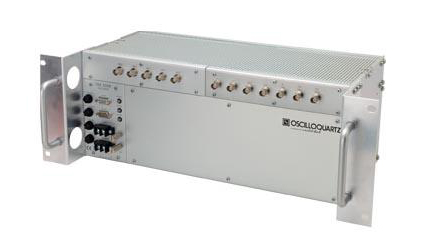
Oscilloquartz has launched its enhanced primary reference time clock (ePRTC) system to enable unprecedented timing accuracy and stability, even when the GNSS signal is lost.
The system provides a timing source for mission-critical transport systems, such as utility networks, government infrastructure and radio access networks, and provides the strict synchronization needed for LTE-A and 5G applications, the company said.
The Oscilloquartz 3230B.
Featuring the OSA 3230B ePRC atomic cesium clock connected to an Oscilloquartz clock combiner and grandmaster, the new solution offers the extremely stable frequency of a cesium clock with the UTC-traceable signal provided by GNSS.
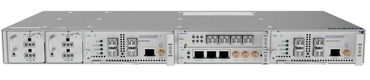
When combined with the OSA 5430, the OSA ePRTC system provides full hardware redundancy and multiple fan-out options including PTP over 10Gbit/s.
“With our ePRTC system, we’re taking reliability and accuracy to the next level. This solution meets the requirements of next-generation mobile networks, offers the precise synchronization needed by many of today’s industries and removes vulnerability to GNSS outages,” said Gil Biran, general manager, Oscilloquartz.
The Oscilloquartz OSA 5430.
“Combining our advanced multi-constellation GNSS receiver with our atomic cesium clock technology creates an outstandingly accurate source of time with guaranteed holdover performance,” Biran said. “This provides vital protection against loss of satellite signal due to jamming, which can be a major problem.
“With the flexibility and redundancy of our OSA 5430, operators can deploy a precise, secure and robust UTC-traceable time and frequency source with high capacity. What’s more, the Syncjack sync probing and assurance technology embedded in our ePRTC enables detection and reporting of inconsistencies between the different references provided to the ePRTC as well as detection of the GNSS spoofing.”
GNSS interference concerns
The dangers of reliance on GNSS alone have become a serious concern across a wide range of industries. Without backup, loss of signal would have a profound impact on critical infrastructure, financial institutions, and military capabilities.
PTP packet-based mobile networks are also highly susceptible to outages unless they are able to hold time and maintain accuracy when GNSS is unavailable.
The OSA ePRTC system removes this vulnerability while delivering higher performance levels than standard PRTC systems and giving operators control of their network synchronization.
The solution comprises two OSA devices: an OSA 3230B ePRC cesium clock compliant to G.811.1 ePRC, which is connected to either an OSA 5421 or OSA 5430 clock combiner and grandmaster clock compliant to G.8272.1 ePRTC. This provides phenomenal holdover accurate to UTC within +/-100 nanoseconds for up to two weeks, ensuring resilience and optimized performance.
“Our OSA ePRTC system is about leveraging the advantages of both timing methods, ensuring the long-term accuracy of GNSS alongside the stability of a cesium beam atomic clock. It even provides major benefits when locked to GNSS by delivering a three-fold improvement in timing accuracy,” said Nir Laufer, product line director, Oscilloquartz.
“In recent years, we’ve seen a big increase in GNSS vulnerabilities due to deliberate spoofing and jamming attacks as well as the natural threats of solar flares and space weather events,” Laufer said. “From global data centers to government institutions, there’s now an urgent need to move away from reliance on GNSS alone. Ensuring backup is now a mandatory step towards secure synchronization. And with our OSA ePRTC, this can be achieved without adding a lot of cost and complexity. We’re giving operators peace of mind and the power to do more with existing infrastructure.”