Category: Mobile

  • Geofeedia, IDV Form Partnership for Threat Assessment

    idvsolutions_visual_command_center Photo: IDV Solutions
    IDV Solutions’ Visual Command Center is a physical security and risk visualization (PSRV) software that unites data from external sources, enterprise systems and internal devices into a real-time, common operating picture of risk and security. Photo: IDV Solutions

    IDV Solutions, a corporation that specializes in business intelligence, physical security and risk visualization software, has formed a technical partnership with Geofeedia, producer of a cloud-based social media monitoring platform. Through the partnership, Geofeedia’s location-based social media monitoring data will now be integrated into IDV Solutions’ Visual Command Center Enterprise Risk Visualization (ERV) software.

    The companies say the combination of the two technologies enables security, supply chain and business continuity teams to gain instant intelligence from multiple social media networks for a myriad of risk events — from a political demonstration to a natural disaster. The location-based visualization filters out excess noise to show important social media posts in the context of locations of interest, such as facilities, employee locations, supply routes or traveling executives.

    “Companies are looking for ways to efficiently gain actionable intelligence from social media,” said Ian Clemens, chief technology officer and co-founder of IDV Solutions. “The immediacy of social media combined with the alerting and locational context offered by Visual Command Center enables organizations to make more effective use of social media to protect employees, facilities and business continuity.”

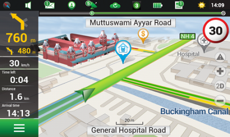
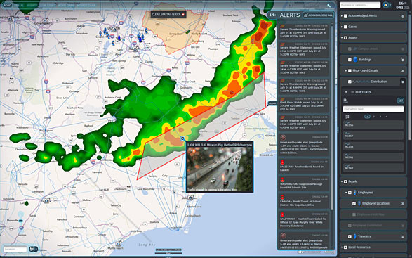
    The Visual Command Center provides a real-time, common operating picture of assets, personnel and operations in relation to potential threats to those assets. It unites information on global sources of risk — such as weather, terrorism and natural disasters — with data from internal data stores and physical security systems on an interactive map and timeline. When a risk is detected near an asset or employee location, the Visual Command Center automatically generates an alert and provides tools to assess whether the risk is a threat and take immediate action to mitigate the impact of the threat.

    The Geofeedia integration complements the Visual Command Center’s Twitter Visualization and Alerting Module by providing information from more social media networks and visualizing all posts within a selected area.

    Geofeedia enables organizations to filter and analyze social media content by location in real time across multiple sources. Users search for a city, address or location name, draw a virtual perimeter around the specific area of interest,and access geo-tagged social media content from within those boundaries.

    “Location resolves the challenge of monitoring the massive amounts of cluttered data to identify meaningful, real-time on-the-ground intelligence when and where it matters most,” said Phil Harris, CEO and co-founder of Geofeedia. “We are thrilled to be able to help more organizations take advantage of our real-time, geotagged social media data to prevent, protect and respond to valuable intelligence.”

  • Navitel Offers Navigation Map of India

    Navitel Offers Navigation Map of India

    Navitel_India
    Photo: Navitel

    Navitel’s navigation map of India is now available for purchase, for use with the Navitel Navigator GPS & Maps app on Google Play. Navitel Navigator is a precise offline GPS navigation with free geosocial services and detailed maps of 59 countries, with 20 million downloads worldwide.

    The map of India contains 2,092,013 km of road graph, 594 627 cities, towns, and other settlements, as well as 5,294,344 POI. Coupled with the address search in more than 6 000 residential and industrial areas of settlements, this map includes the detailed housing system data with due account for the number of floors, detailed road networks with all streets, roads, and indicated traffic direction, road interchanges, roundabouts, and other important road information.

    The map contains 149 3D points of interest, including:

    • Delhi – Akshardham Temple, Qutub Minar, Laxmi Narayan Mandir, and Lotus Temple.
    • Gujarat – ISCON Mall, Satyam Centre, the Metropole Hotel, Kaizen Hospital.
    • Karnataka – Bangalore Palace, Software Technology Park of India, Jamia Masjid, Hotel Savannah Sarovar Premiere, Jawahar Bal Bhawan park.
    • Tamil Nadu – Chennai International Airport, Chennai Railway Station, Manorama Hotel, Lemon Tree Hotel.
    • Haryana – Vardhman Star Mall, YMCA University of Science and Technology, Mini Secretariat, Sarvodaya Hospital, Gurgaon Centre.
    • Chandigarh – Panjab University, Chandigarh College of Engineering & Technology, Haryana and Punjab Secretariat, Hotel Royal Plaza.

    Details for Map of India, Q1 2015:

    • 2,092,013 km of road graph;
    • 594,627 settlements on the map;
    • 6,614 settlements allowing the address search;
    • 8,217,526 addresses;
    • 149 3D points of interest;
    • 5,294,344

    Android OS device users can purchase a license key to the new product at Google Play and from the program menu by selecting “My Navitel” > “Purchase maps”.

    The Q1 2015 map of India is compatible only with 9.1.0.0 and later versions of Navitel Navigator.

  • Ride Service Uber Acquires Mapping Company DeCarta

    Ride service Uber is buying mapping and search startup deCarta, reports Mashable, which said it learned of the deal from an Uber representative.

    The deal was expected to close earlier this month. Uber plans to use deCarta’s technology and talent to fine-tune its products and services that rely on maps, including UberPOOL, the smartphone-based ride-sharing app.

    Thirty out of 40 deCarta employees will remain with the company, including Kim Fennell, chief executive officer and president, Mashable said. deCarta will continue to operate as a wholly-owned subsidiary of Uber, but will use its own name.

    Founded in 1996, deCarta is privately held, and headquartered in San Jose, Calif., with international offices and distributors in Germany, China, Brazil and South Africa. deCarta is a global location-based services (LBS) technology company that provides specialized geospatial technologies for online mapping, routing, navigation, geocoding, local search and geo-data integration and processing. The company’s platform is used by high-volume LBS applications and services in the mobile, Internet, enterprise-fleet and automotive markets.  Customers and technology partners include Samsung, Inrix, T-Mobile, FullPower MotionX GPS Drive, Appello, Denso, Ford, GM OnStar, Masternaut, Wireless Matrix, eMapgo, Nokia/HERE, Spot-On-Time, Telstra/Sensis, TomTom, WHERE/eBay.

    In February, Uber announced a partnership with Starwood Hotel and Resorts where Starwood Preferred Guest members earn points towards free hotel stays for every dollar spent riding Uber.


  • Esri and RouteSmart Help Postal Carriers Reduce Operating Costs

    Esri and RouteSmart Technologies, Inc., are collaborating to help postal organizations deliver packages reliably, efficiently, and accurately. The companies provide comprehensive dynamic routing solutions based on Esri’s ArcGIS platform.

    National postal and global and regional parcel delivery services, including Whistl, Posti, and Swiss Post, are among the customers that leverage these routing solutions. Most customers have experienced cost savings of 15 percent, on average, through reduced working hours, mileage, and new vehicle acquisition. Customers also report growth opportunities through opening new lines of distribution business to support the burgeoning e-commerce delivery segment.

    “By integrating location-based analysis with a postal organization’s traditional business systems, such as sorting machines and address management systems, we are solving territory planning and route management challenges these organizations are facing,” said Chris Walz, vice president of sales and marketing for RouteSmart Technologies. “With our help, they can align to the new realities of postal and parcel distribution economics brought on through the growth of e-commerce shipping volumes and declining letter volumes.”

    Esri and RouteSmart will share how they are helping postal organizations continue to be drivers of innovation in transportation and operational efficiencies at the European Post and Parcel Services Conference in Vienna, Austria, March 24–26.

    “One of the biggest upcoming challenges for the postal industry will be the adoption of fully automated vehicles for deliveries,” Hall said. “With our partner RouteSmart, we provide a path for migration with the help of advanced location intelligence, optimization, and analysis tools.”

  • New Report Considers GNSS Market Outlook 2015-2020

    Research and Markets has added the report “Global Navigation Satellite Systems Market Outlook 2020” to its offerings. The global core GNSS market is forecast to grow at a CAGR of 9 percent during 2015-2020.

    In the report, the analysts have identified and deciphered the market dynamics in important GNSS industry segments, highlighting the areas offering promising possibilities for companies to boost their growth, according to Research and Markets. The report studies the market by sectors including location-based services (LBS), transportation (further divided into road navigation, rail navigation, air navigation and marine navigation), surveying and agriculture. The GNSS application market is further studied by region: North America, Europe, Asia-Pacific, and Rest of World.

    The report provides a complete overview of the GNSS market globally. All the current trends and drivers, coupled with potential growth areas of the GNSS industry, have been evaluated in the report. Furthermore, the report provides information on opportunities in the industry for different companies in the chapter titled Opportunity Assessment.

    Additionally, to provide an exhaustive knowledge of the prospects for GNSS players on the geographical front, the report provides comprehensive knowledge of the 10 most worthwhile GNSS markets around the world (U.S., Canada, UK, France, Germany, RussiaJapan, China, South Korea and India). It includes information about the present state and future outlook of the LBS and telematics markets in these countries along with information about their personal navigation systems such as GPS, BeiDou,Galileo, GLONASS, QZSS and IRNSS.

    The report also looks into the competitive landscape covering business overviews, key financials, product analyses, recent developments and strengths and weaknesses of each of the players.

    Key trends considered in the report include:

    • Driverless Car: New GNSS Technology Use
    • Indoor GNSS Positioning Poised for Growth
    • People, Pets and Thing Finder: The Next Attraction
    • GNSS Based Products: A Burgeoning Market Opportunity
    • GNSS Jamming Gaining Attention

    Companies mentioned include:

    • AgJunction
    • CSR
    • Furuno Electric Co Ltd.
    • Garmin Ltd.
    • MiTAC International Corp.
    • Raytheon Company
    • Rockwell Collins
    • TomTom NV
    • Topcon Corporation
    • Trimble Navigation Ltd.


  • Tallysman Application Enables Companies to Build Fleet Networks

    Tallysman Wireless has released a hosted data service for its TruFleet AVL (Automatic Vehicle Location) system, which runs on MOTOTRBO digital two-way radio networks. The new service enables Tallysman’s channel partners to build and brand their own carrier network of individual radio systems and to generate an ongoing revenue stream using any MOTOTRBO radio configuration, from conventional repeaters though to wide area trunking systems.

    TruFleet is a web browser interface for Tallysman’s fleet management AVL application that enables clear fleet overview and management. It delivers excellent web-based reporting capabilities, is very reliable, and has a rich, intuitive interface that is simple to master and to operate.

    The new TruFleet hosted data service enables channel partners to offer a cost-effective AVL solution for fleet sizes with as few as 15 subscribers.

    “The TruFleet solution generates compressed batched messages transmitted at a low reporting rate, similar to first generation Tallysman Sprite devices, but a patent-pending algorithm provides much greater data compression, conserving data bandwidth,” said John Seymour, director of data systems at Tallysman. “This enables us to to provide precise positioning at rates that are competitive with cellular systems.”

  • Connor-Winfield Offers TCXO for Compliance with ITU-T G.8262

    Connor-ML602-TCXO
    Photo: Connor-Winfield

    Connor-Winfield is offering two new temperature compensated crystal oscillator models. TL602 and ML602 TCXO models are designed for use in conjunction with 0.1-Hz (and higher ) filter bandwidths for compliance with T1-based hierarchy specifications such as ITU-T G.8262 Option 1 and 2 ECC and ITU-T G.813 Option 1 and 2 SEC, Stratum 3 for Sonet, IEEE1588 and Synchronous Ethernet. CW’s TCXO line utilizes analog temperature compensation for excellent short-term stability characteristics, the company said.

    The TL602 and ML602 TCXOs maintain 280-ppb pk-pk frequency stability over the industrial temperature range of -40 to +85C. They are also excellent frequency reference choices for small cell, wireless and instrumentation applications, Connor-Winfield said.

    Features:

    • Available frequencies are 10 MHz, 12.8 MHz, 19.2 MHz, 19.44 MHz, 20 MHz and 24.576 MHz.
    • LVCMOS or clipped sine.
    • Fixed output or Voltage control.
    • Meets MTIE and TDEV masks measured at 0.1-Hz bandwidth.
    • Short term stability 1×10⁻¹⁰ performance.
    • 280-ppb peak-to-peak temperature stability over the full industrial temperature range.
    • Sub-300 ps jitter performance over 12 kHz-20 MHz band.
    • Lifetime accuracy of +/- 4.6 ppm.
    • Full ROHS and REACH compliance.
    • 7×5 mm (TL602) or 5×3.2 mm (ML602) packaging options.
  • MWC 2015: Rohde & Schwarz Adds Option for Analyzing Mobile Apps to Test Solution

    MWC 2015: Rohde & Schwarz Adds Option for Analyzing Mobile Apps to Test Solution

    R&S CMW-PQA Test System for Performance Quality Analysis. by Rohde & Schwarz.
    R&S CMW-PQA Test System for Performance Quality Analysis, by Rohde & Schwarz.

    Rohde & Schwarz is presenting its new over-the-top (OTT) application analysis solution at Mobile World Congress, being held this week in Barcelona, Spain. The solution enables network operators and mobile device manufacturers to quickly and easily analyze and assess the behavior of OTT apps on mobile devices the data traffic they cause.

    The additional software option is for the established R&S CMW-PQA performance quality analysis test system.

    OTT apps are applications such as YouTube and WhatsApp that use mobile networks, but are not a service offered by the network operator. Such apps can cause uncontrolled data traffic on an operator’s network and excessively drain mobile phone batteries.

    The R&S CMW-PQA OTT software now allows users to check which server the OTT app registers with, the number of connections it initiates and the network traffic volume it generates. The R&S CMW500 wideband radio communication tester, the core component of the R&S CMW-PQA, also offers a unique IP and protocol statistical analysis function that enables users to analyze how much the OTT app drains the mobile phone battery. The PACE software fromRohde & Schwarz subsidiary ipoque integrates this precise application identification function into the device.

    The intuitive user interface enables users to quickly and easily configure tests as usual, Rohde & Schwarz said. Analysis results are available in a clearly structured graphical report. Users will have a clear overview of an app’s data throughput over time, its connected and idle state information, and when RRC messages were initiated.

    The OTT solution for the R&S CMW-PQA test system is now available from Rohde & Schwarz. Customers who already have an R&S CMW-PQA do not need to purchase a hardware upgrade. A software upgrade is all that is required to add the OTT functionality to their system.

    The test setup for OTT application behavior is on display at Hall 6, Booth C40, at Mobile World Congress.

  • Google Maps Takes Street View Camera through Amazon Canopy

    Google Maps Takes Street View Camera through Amazon Canopy

    The Street View Trekker on a zipline in the Amazon Rainforest.
    The Street View Trekker on a zipline in the Amazon Rainforest. (Photo credit: Google Maps)

    New imagery of the highest canopy in the Amazon rainforest is now available on Google Maps. The Amazon rainforest is one of the most diverse ecosystems in the world, with many species high in the canopies of the forest still undiscovered.

    “Starting today, with the help of our partners at the Amazonas Sustainable Foundation (FAS), you can begin to unlock some of the wonders of the forest, by traveling from the upper canopy to the forest floor with Google Maps’ first zipline Street View collection,” wrote Karin Tuxen-Bettman, program manager, Google Earth Outreach on a March 1 blog.

    The project is part of Google’s partnership with FAS, who three years ago invited Google Maps to the Rio Negro Sustainable Development Reserve. “Their hope is that sharing the imagery of their local communities, rain forests and rivers with the world will raise awareness and support for their efforts to conserve these areas,” Tuxen-Bettman writes.

    The imagery was collected through Google Map’s Trekker Loan Program, which loans out the Street View camera and technology to tourism boards, non-profits, universities, and research organizations to help collect imagery of remote places.

    The Amazon map imagery was gathered through boat travels on 500 kilometers of rivers, hiking on 20 kilometers of forest trails and ziplining through forest canopies.

    “We hope it inspires you to embark on your own virtual expedition of the Amazon (you can leave the bug repellent at home!),” Tuxen-Bettman writes.

    The map on this page  shows where Google Maps has yet to collect Street View imagery.

    Rio Mariepauá, Brazil. (Photo credit: Google Maps)
    Rio Mariepauá, Brazil. (Photo credit: Google Maps)
  • Meitrack Offers GPS Tracker for 3G Networks

    Meitrack-T1-VEHICLE-TRACKER-WGPS tracking manufacturer Meitrack Group is introducing a tracker that runs on 3G networks. GPS trackers have been running on 2G networks, but soon many wireless carriers will discontinue the outdated 2G technology. Meitrack said it is hard at work making the transition to make all of its current trackers work on the 3G network standard.

    The first model released is the T333 GPS tracker, which offers real-time tracking, history reports, assisted GPS tracking, geofence creation, and an S.O.S. panic button. The tracker can be installed in vehicles ranging from everyday family cars, to construction and commercial trucks.

    The strong outer aluminum casing effectively secures the internal components from exposure to the elements and heat. At 190 grams, the T333 is lightweight and small enough to be securely installed in areas of minimal space, the company said. Meitrack has installed the u-Blox 7 GPS module, upgrading the processing speed and sensitivity. Not only does the T333 GPS tracker run on 3G networks, but it can also run on 2G as a backup if a 3G network is not available.

    The T333 also comes equipped with digital and analog inputs that transform the GPS tracker into a central hub where other accessories can be simultaneously attached and synced. These accessories include fuel sensors, RFID card readers, handset phones, cameras, and even LCDs and LEDs displays.

  • MWC 2015: Geotab Offers Add-On Extender for All-Vehicle Support

    Geotab, a telematics engineering company, has released its IOX-CAN extender, a plug-and-play solution that allows partners to send data from their device over a private CAN network in the vehicle, supporting integrations on all vehicle types.

    Geotab is exhibiting at Mobile World Congress 2015, at Hall 3, Stand 3J20.

    According to Geotab, Fortune 500 companies, including 40 percent of the top ten fleets and 18 percent of the top 100 fleets in North America, rely on Geotab’s solutions to improve productivity, optimize fleets through the reduction of fuel consumption, enhance driver safety, and achieve stronger compliance to regulatory changes.

    A number of companies are already leveraging the IOX-CAN extender to send data from their devices to the MyGeotab system. Geotab’s integration with Mobileye, a technology company that develops vision-based Advanced Driver Assistance Systems (ADAS) providing warnings for collision prevention and mitigation, has been upgraded with the IOX-CAN extender allowing full support for all vehicle types, including OBDII (on-board diagnostics II) vehicles.

    Geotab’s new add-on solution allows Mobileye devices to plug into Geotab’s GO6 and GO7 devices, allowing Mobileye data to be sent to the MyGeotab software platform, where it can be viewed and analyzed by dispatchers and fleet managers.

    “Our solutions are designed to make the roads safer for everyone as the issue of distracted driving continues to be a problem,” said Elad Serfaty, vice president and general manager of Mobileye Aftermarket. “Working with Geotab allows us to not only provide feedback to the driver, and with managers who can effect change where needed, but we can do this across all vehicle types.”

    “Expanding our integration capabilities and continuing our work with Mobileye is a natural evolution as more and more companies realize the benefits of fleet management,” said Neil Cawse, CEO, Geotab. “Providing collision warnings to drivers just before a crash is the first step to creating a safer driving environment for everyone.”

  • MWC 2015: Rx Networks Updates GNSS Extended Ephemeris Solution

    Rx Networks Inc., a mobile location technology and services company, announced the upcoming release of its GPStream PGPS v8 extended ephemeris solution at Mobile World Congress 2015, taking place this week in Barcelona, Spain.

    The patented technology, being used in hundreds of millions of devices, is designed to speed up the time-to-first-fix (TTFF) of any GNSS chipset while improving acquisition sensitivity in challenging environments.

    Compared to the previous version, GPStream PGPS v8 effectively doubles accuracy performance while supporting all four global GNSS constellations. GPStream PGPS v8 will be available for integration testing in the second quarter of 2015, with commercial release in the fourth quarter of 2015. (Full commercial support for Galileo will remain subject to the readiness of the constellation).

    All major GNSS semiconductor vendors are now offering or developing multi-constellation support to improve availability in challenging environments. Quad-constellation support also enables OEMs and GNSS chipset manufacturers to meet any national or regional market requirement. Availability of extended ephemeris across the four constellations is required to ensure fast TTFF and optimal sensitivity. Early lab access to the latest GPStream PGPS v8 solution from Rx Networks can help chipset manufacturers validate performance early in the development cycle and thus accelerate the time to market for their new multi-constellation chipsets.

    A key component of any extended ephemeris solution is the accuracy of the orbit and clock predictions. This accuracy is often presented as an error in meters compared to the native broadcast ephemeris transmitted by the satellites. The latest version of GPStream PGPS improves this accuracy by a factor of two, compared to its previous release. For example, day 1, 7 and 14 accuracies for GPS are now 2.8 m, 4.5 m and 11.4 m compared to 6.3 m, 12.5 m and 30.2 m previously. BeiDou and Galileo will experience similar performance. GLONASS is also significantly improved, with day 1, 7 and 14 accuracies of 1.8 m, 6.5 m and 13.7 m compared to 7.3 m, 13.4 m and 27.2 m previously.

    “Rx Networks continues to expand its relationships with major OEMs and GNSS chipset manufacturers to help them deliver innovative, multi-constellation and highly accurate GNSS performance,” said John Carley, senior product manager at Rx Networks. “This latest release reaffirms our commitment to provide best in class Assisted-GNSS solutions for the mobile market.”

    Rx Networks is exhibiting in Booth 5H75 at Mobile World Congress.