Category: Applications

  • Net Insight leads development of next-generation PNT technology

    Net Insight leads development of next-generation PNT technology

    Focusing on timing synchronization, the project is supported by ESA NAVISP on behalf of the Swedish National Space Agency to advance resilient timing and positioning.

    Net Insight has been awarded a development project through the European Space Agency’s Navigation Innovation and Support Program (NAVISP), a European program designed to foster innovation in the PNT domain and strengthen Europe’s technological competitiveness. 

    The project, co-funded by the Swedish National Space Agency, aims to accelerate the development of robust positioning, navigation and timing (PNT) technology, to address growing societal needs and increase risks to critical infrastructure.

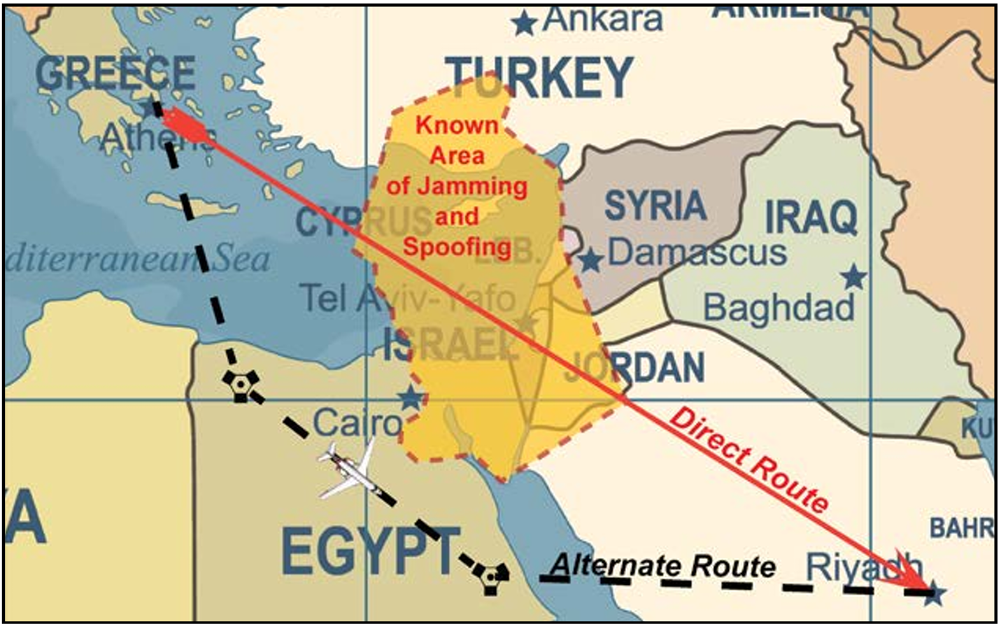
    Precise timing signals are a critical component of everything from telecommunications and 5G networks to transportation and energy systems. Traditionally, GNSS systems such as GPS and Galileo have been the standard for time synchronization. However, today’s geopolitical landscape and the increasing prevalence of disruptions such as jamming and spoofing highlight the need for robust, complementary solutions that can ensure reliable operation under all conditions, according to Net Insight.

    “This initiative exemplifies how the Swedish space industry can contribute to addressing complex European challenges related to critical infrastructure,” said Christer Nilsson, vice director general of the Swedish National Space Agency. “Combining Swedish technical excellence with European collaboration is a powerful model for strengthening robustness and operational reliability within PNT.”

    “Society depends on technologies that are not only advanced, but also robust and operationally reliable, and capable of withstanding disruptions and external interference,” said Per Lindgren, group CTO and head of synchronization at Net Insight. “With this project, we are strengthening the development of solutions that can deliver reliable time synchronization even under demanding conditions, thereby securing critical infrastructure for the future.”

    Through collaboration with the Swedish National Space Agency and ESA’s NAVISP program, the project gains access to both national and European funding and support for research and development in PNT technology. At the same time, it enables national initiatives to be aligned with broader European strategies for robust and operationally reliable PNT architectures.

    NAVISP is designed to stimulate new technologies and applications beyond traditional GNSS-based systems and plays a key role in Europe’s efforts to ensure robust and competitive PNT solutions.

  • Lockheed Martin secures $105M contract for GPS IIIF operations

    Lockheed Martin secures $105M contract for GPS IIIF operations

    Lockheed Martin has received a potential $105 million firm-fixed-price task order from the U.S. Space Force’s Space Systems Command to supportGPS IIIF launch and on-orbit testing.

    The award covers services related to the Architecture Evolution Plan (AEP) operational control system. This includes support for launch, early orbit operations and eventual disposal of GPS IIIF satellites (space vehicles SV11-22). The effort is part of ongoing work to sustain and manage next-generation positioning, navigation and timing capabilities for military users.

    Work under the sole-source task order will take place in Colorado Springs, Colorado, through March 2030. The contract is managed by SSC’s satellite communication and PNT office at Peterson Space Force Base. SSC obligated $13.4 million from fiscal 2026 research, development, test and evaluation funds at the time of award.

    Lockheed Martin’s previous contracts supporting the GPS IIIF program include a nine-year, $1.36 billion contract in 2018 to produce the 11th and 12th GPS IIIF satellites, and a $509.8 million contract modification for GPS IIIF space vehicles 21 and 22 granted in May 2025. SV-21 and SV-22 are expected to be delivered by November 2031.

  • SWF: GNSS interference a key issue for space security

    The Secure World Foundation’s annual report, “Global Counterspace Capabilities: An Open Source Assessment,” is now available.

    The 2026 edition compiles and assesses publicly available information on counterspace capabilities being developed by 13 countries across five categories: co-orbital, direct-ascent, electronic warfare, directed energy and cyber.

    The report discusses jamming against GNSS and other position, navigation and timing (PNT) satellites. It assesses current and near-term future capabilities for each country, along with their potential military utility, and discusses their space situational awareness capabilities.

    Countries covered in this report are: the United States, Russia, China, India, Australia, France, Germany (added this year), Iran, Israel, Japan, North Korea, South Korea, and the United Kingdom.

    Download the report here.

  • FAA updates GNSS Interference Resource Guide

    FAA updates GNSS Interference Resource Guide

    The U.S. Federal Aviation Administration (FAA) has updated its GNSS Interference Resource Guide with updated information on GNSS vulnerabilities and general edits throughout.

    The FAA’s Flight Technologies and Procedures Division (AFS-400) developed the guide to provide U.S. operators and pilots with the most current information regarding GPS and GNSS jamming and spoofing.

    According to the guide’s introduction, “The impacts of safety hazards from GNSS interference rapidly spread over the past few years and is persistent. As the threat of GNSS jamming and spoofing is constantly changing, the FAA will update this resource guide to provide the best guidance in the rapidly changing environments.”

    Download the guide here.

  • Advanced GNSS ionospheric sensor sent into orbit

    Advanced GNSS ionospheric sensor sent into orbit

    The U.S. Naval Research Laboratory (NRL) has successfully launched the GNSS Orbiting Situational Awareness Sensor (GOSAS), one of three advanced experimental payloads.

    GOSAS was aboard the Space Test Program’s (STP) Satellite-7, which launched at 4:33 a.m. PDT on April 7 from VandenbergU.S. Space Force (USSF) Base, California.

    The other payloads are the Lasersheet Anomaly Resolution andDebris Observation (LARADO) instrument and the Gadolinium Aluminum Gallium Garnet (GAGG) Radiation Instrument (GARI-1C).

    GOSAS will improve the reliability of navigation and communication systems for warfighters.

    “The GOSAS is a CubeSat-compatible, programmable dual GPS receiver designed to characterize the orbital GNSS environment and produce high-quality ionospheric space weather products,” said Scott Budzien, PhD, NRL research physicist and GOSAS principal investigator. “Understanding and predicting space weather is critical for ensuring the accuracy of GPS and the integrity of military communications.”

    GOSAS is a follow-on to the NRL experiment GROUP-C (GPS Radio Occultation and Ultraviolet Photometry-Collocated) experiment on the International Space Station that took place 2017-2023 and serendipitously detected GPS ground interference.

    GOSAS originated in 2020 with the mission of increasing GPS accuracy for the warfighter.

  • Survey to determine highest mountain peak in Bangladesh

    Survey to determine highest mountain peak in Bangladesh

    A government-sponsored survey has set out to find the highest peak in Bangladesh. Field teams for the Survey department under the Ministry of Defense have begun field work in the remote hill areas of Ruma and Thanchi upazilas in Bandarban district.

    The survey, taking place April 4-12, will use modern geodetic methods and advanced GNSS technology. The surveyors will follow international standards to determine the height of the country’s highest peak above mean sea level (MSL) with centimeter-level accuracy, including latitude, longitude, and elevation.

    Through the use of a newly developed geoid model, it will be possible to accurately convert ellipsoid heights obtained from GNSS receivers into mean sea level (MSL) elevations of the mountain peaks, according to the government.

    The survey is expected to resolve the long-standing debate over whether Tajingdong, Keokradong or Saka Haphong is the country’s highest mountain peak.

  • VIAVI partners with Ground Control to enable assured maritime vessel tracking

    VIAVI partners with Ground Control to enable assured maritime vessel tracking

    VIAVI Solutions is partnering with satellite communications and positioning solutions provider Ground Control to integrate its Secure µPNT STL-1000 into the RockFLEET Assured asset tracking and assured navigation solution.

    Viavi’s Secure µPNT STL-1000 is a compact software-defined receiver designed to operate with the Viavi SecureTime altGNSS LEO services. Delivering precise timing with holdover capability, it enables tracking, authentication and assured navigation in denied, degraded and disrupted space operational environment, also known as D3SOE.

    “With jamming and spoofing now a core element of cyber warfare, resilient PNT solutions are no longer optional,” said Doug Russell, senior vice president and general manager, Aerospace and Defense, Viavi. “The Secure µPNT STL-1000 enables assured, uninterrupted operations, especially in contested environments. Its compact size and low power consumption makes it ideal for applications that require an extremely small, low-power, secure, resilient embedded PNT receiver.”

    “As the frequency of jamming and spoofing continues to rise, reliance on GPS/GNSS signals alone increasingly exposes both commercial and military operations to risk,” said Alastair MacLeod, CEO of Ground Control. “Integrating Viavi’s Secure µPNT STL-1000 into RockFLEET Assured delivers a trusted secondary position source, strengthening resilience for mission‑critical operations across defense, maritime and critical infrastructure environments.”

    RockFLEET Assured is a marine-grade assured position, navigation and timing (A-PNT) solution designed to support maritime vessel navigation and oversight in GNSS-denied environments.

  • VectorNav introduces high-G capability across tactical IMU and GNSS/INS series

    VectorNav introduces high-G capability across tactical IMU and GNSS/INS series

    New 95G and 250G accelerometers and 4000°/sec gyroscope ranges deliver navigation solution integrity in high-dynamic environments, supporting interceptors, missiles and hypersonic platforms.

    VectorNav Technologies has announced 95G and 250G accelerometer and 4000°/sec gyroscope ranges across its Tactical Series inertial measurement unit (IMU) and inertial navigation system (INS) product line.

    The enhancement directly addresses urgent requirements from defense contractors and platform developers operating in high-G mission profiles.

    Defense modernization priorities are accelerating procurements of interceptors, missiles, and hypersonic platforms that must operate through launch, interception, and aggressive maneuvering — often in environments where GPS is denied or degraded. In these conditions, navigation performance depends on the IMU’s ability to maintain solution integrity without saturating.

    The extended-range Tactical Series is designed to meet that requirement, providing the core inertial measurements that enable resilient position, navigation, and timing (PNT) solutions to operate through mission-critical flight phases where conventional sensors fail.

    “The demand signal from our customers has been unmistakable,” said Jakub Maslikowski, VP of Business Development. “As platforms become faster, more maneuverable, and face increasingly sophisticated threats, high-performance inertial navigation solutions are needed at scale to meet the evolving demand. With nearly 20 years supporting these mission profiles, we know these applications—and the extended-range gyro and accelerometer will enable faster integration and more rapid fielding of reliable systems.”

    The extended-range accelerometer and gyroscope are available across the full VN-110 IMU and VN-210 / VN-310 INS product family, supporting applications including:

    • high-speed interceptor platforms
    • rapid-response strike systems 
    • hypersonic and advanced maneuvering vehicles
    • counter-UAS and air defense systems
    • next-generation precision guidance

    The extended-range configurations are drop-in compatible with existing platforms — no changes to form, fit or function — enabling immediate upgrades without redesign.

  • ArkEdge builds micro-satellite constellation for maritime real-time tracking

    ArkEdge builds micro-satellite constellation for maritime real-time tracking

    ArkEdge Space successfully launched its micro-satellite AE1a on March 30, and has begun initial checkout following the establishment of communications through test radio signals.

    AE1a is a technology demonstration satellite developed to advance maritime digitalization by enabling wide-area, real-time vessel tracking and communications. The satellite adopts ArkEdge Space’s standardized 6U satellite bus in its large-antenna configuration. In addition to demonstrating a deployable antenna for VDES (VHF Data Exchange System) applications, AE1a will improve and validate core technologies for a VDES receiver.

    AE1a will operate in coordination with AE1d, which began operations in January 2025, and AE3Va, which began operations in June 2025, forming a three-satellite constellation for demonstration across wide-area maritime areas.

    AE3Va continues to acquire AIS signals across multiple sea areas, including waters around Japan and vessel-congested areas along critical shipping lanes. Accumulated reception data is being systematically verified and analyzed.

    Going forward, the program will advance from reception-focused demonstration to two-way communications, including transmission from orbit. This will enable satellites to deliver operational information directly to vessels, expanding the scope of VDES demonstration and advancing progress toward concrete use-case validation across the maritime sector.

  • CHC Navigation announces major updates to GNSS receivers and iBase

    CHC Navigation announces major updates to GNSS receivers and iBase

    CHC Navigation has announced major updates to its i93, i85 and i76 GNSS receivers, as well as the iBase professional base station. The updates are designed to further improve positioning stability, simplify field setup, and expand operational capability across demanding surveying environments.

    Enhanced RTK performance with the CHCNAV StellaX GNSS chip
    The updated i93, i85 and i76 receivers integrate the CHCNAV StellaX GNSS chip with multi frequency signal tracking and advanced anti interference mitigation. This design is intended to support more reliable GNSS RTK positioning and more consistent data collection in complex terrain and in areas with partial GNSS satellite visibility.

    PointSky GNSS corrections service for remote surveying
    To reduce reliance on cellular networks and local radio links, the updated i93 and i85 now include a one-year standard subscription to the CHCNAV PointSky service. PointSky delivers GNSS corrections via satellite, enabling users to reach a 2.5 cm precision fix in three to five minutes. This capability supports surveying operations in remote locations such as mountains, forests and deserts where network coverage can be limited or unavailable.

    Longer range radio operation and simplified iBase startup
    The iBase base station now integrates CHCNAV DistLink technology and improved data compression to increase radio sensitivity and support up to 30 km coverage for linear projects such as highways and railways. Power consumption has also been optimized to support more than 13 hours of continuous operation without external batteries. To streamline setup, iBase includes a one button startup sequence designed to automatically pair with rover units, reducing the need for manual parameter configuration in the field.

  • Infleqtion launches quantum timing solution with Safran partnership

    Infleqtion launches quantum timing solution with Safran partnership

    Infleqtion has announced availability of its first quantum-enabled precision timing solution delivered as part of the company’s partnership with Safran Electronics & Defense. The new solution includes Infleqtion’s Tiqker quantum optical clock, which has been integrated and validated with Safran’s White Rabbit and SecureSync systems.

    Modern systems, from financial markets to military operations, telecom networks and datacenters, depend on technologies such as GPS or GNSS for precise timing, but these are vulnerable to jamming, spoofing, and natural disruption. As threats to traditional timing infrastructure grow, the need for resilient, independent alternatives has become critical.

    In a recent live demonstration conducted in partnership with Quantum Corridor, the solution integrating Tiqker, White Rabbit and SecureSync system was validated in a real-world environment, demonstrating picosecond accuracy vs. nanosecond GPS accuracy.

    The combined, validated solution delivers enhanced stability and resilience, ensuring continuity of operations for mission-critical systems even in environments where traditional timing signals are challenged or denied.

    The collaboration between Infleqtion and Safran Electronics & Defense makes the validated solution available to customers globally, across allied defense, telecommunications, and critical infrastructure sectors, enabling rapid deployment of precision timing architectures designed to operate even in GNSS-challenged environments.

  • EASA, EuroControl publish action plan on safety during GNSS interference

    EASA, EuroControl publish action plan on safety during GNSS interference

    The European Union Aviation Safety Agency (EASA) and EuroControl have published a joint action plan designed to strengthen the safety and resilience of European aviation operations amid the growing challenge of GNSS interference.

    GNSS provides aircraft with precise positioning, navigation and timing information that is essential for a wide range of functions. Interference with the signals has become a regular occurrence, in particular on the edge of conflict zones, and poses a threat to safety. The action plan focuses on maintaining safety in the near term while limiting impacts on airspace capacity and containing the threat of GNSS interference. It sets out short, mid- and long-term measures to mitigate the threat with harmonized operational procedures and to strengthen the robustness of GNSS‑based operations by clearly defining who needs to act, and by when.

    “While the potential threat to aviation safety from GNSS interference has so far been mitigated by short-term actions such as raising pilot awareness, it is clear that more needs to be done,” said Florian Guillermet, EASA executive director. “This action plan lays out and prioritizes short, mid and longer-term actions and, importantly, also assigns roles to the various aviation actors. By working together with EuroControl and pooling our expertise, we have been able to create a strong plan that will enable the wider sector to come together to counter this threat.” 

    “GNSS interference remains a significant and evolving challenge for European aviation, making today’s action plan an important step forward in our collective response,” said Raúl Medina, director-general, EuroControl. “The action plan concretely supports our Member States and aviation partners as we work together to ensure the evolution and resilience of aviation’s critical infrastructure — one of the core goals of EuroControl’s Trajectory 2030 strategy. I welcome the strong cooperation and close coordination with EASA and all our partners across the aviation sector on this plan, which demonstrates our shared commitment to safety, and aims at delivering tangible benefits for the network, operators and passengers by making GNSS‑based operations more robust.”

    Key elements of the joint action plan
    The action plan is built on several core pillars designed to strengthen Europe’s ability to detect, manage and mitigate GNSS interference.

    Through joint monitoring and data-sharing, EASA and EuroControl aim to establish a common, validated operational picture of GNSS interference events across Europe, enabling more accurate detection, reporting and situational awareness. By pooling expertise and operational data, the two organisations will deepen their understanding of interference patterns, operational impacts and associated safety risks, with the aim of delivering consistent and harmonized guidance to air navigation service providers (ANSPs), airlines, and national authorities to ensure rapid and aligned responses to interference incidents.

    In close partnership, EASA and EuroControl will develop updated operational guidance for flight crews and air traffic controllers to help them manage disruptions effectively and maintain safe operations in degraded navigation environments and join forces and expertise for investigations into ongoing GNSS interference.
    The two organisations will also promote improved mechanisms for timely information exchange through Member States, ensuring that events with both civil and military dimensions are addressed in a coordinated and transparent manner to minimize disruption and preserve airspace capacity.

    The action plan envisages close collaboration with A/C manufacturer and avionics industry to support the development of more robust, interference‑resilient avionics solutions over the longer term. It addresses the concerns expressed in a letter sent on June 6, 2025, by 13 EU Member States to the European Commission that called for immediate and coordinated European action to address the growing number of Radio Frequency Interference (RFI) events affecting GNSS‑based systems. The action plan also integrates proposals and guidance from international partners including the International Civil Aviation Organization (ICAO), and the International Air Transport Association (IATA).

    Background
    GNSS enables more efficient flight paths, reduces fuel consumption, and supports the implementation of Performance-Based Navigation (PBN), which allows aircraft to fly more direct routes and operate safely in areas with limited ground-based infrastructure.

    However, the growing challenge of RFI — whether intentional (jamming or spoofing) or unintentional — poses a threat to the resilience of these systems. The most severe interference typically occurs near conflict zones, but GNSS performance may be affected well beyond these areas. Although aircraft can operate safely without GNSS, disruptions can reduce resilience and the continuity of operations.