CyArk, a California-based nonprofit, used UAVs, lidar and GNSS equipment to scan Big Basin Redwood State Park in Santa Cruz, California and create a model of it. The model shows drastic changes from climate change and the after-effects of the 2020 CZU Lightning Complex Fire.
CyArk was contracted by the California park system and Google Art & Culture to document climate-related changes in the state forest, including the 2020 CZU Lightning Complex Fire, which burned more than 97% of the oldest park in California, destroying historic structures and most of the park. The fire was detrimental to the park’s landscape, which is still plagued by drought.
DJI quad-rotor UAVs, a fixed-wing senseFly UAS, lidar and photogrammetry data brought in by RealityCapture software, and Topcon Positioning Group GNSS receivers among other technologies were used by CyArk to map the large-scale project.
The model created from the flyover of the Big Basin can be seen here.
CyArk digitally documents culturally historical places around the globe in 3D to preserve each site’s story using GNSS and lidar technology. They have worked at more than 200 sites in more than 40 countries.
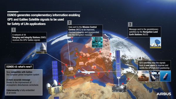
On Dec. 7, the European Geostationary Navigation Overlay Service (EGNOS) V3, a satellite-based navigation augmentation system designed by Airbus, passed the System Critical Design Review (CDR). EGNOS V3 supports safety-critical aircraft applications and will soon provide services to maritime and land users.
New services provided by EGNOS V3 are based on multiple frequencies from GPS and Galileo constellations and will provide protection against cyberattacks. As it successfully passed CDR, this multi-constellation and multi-frequency satellite-based navigation augmentation system is a step forward in improving EGNOS accuracy, robustness, and overall coverage in Europe.
EGNOS V3 relies on three operation centers and 44 monitoring stations across Europe. It monitors the signals from satellite navigation systems and generates augmentation messages broadcast to all users using transponders and geostationary satellites. Airbus is currently designing more Galileo satellites, which will further improve EGNOS accuracy and robustness and the resilience of its signal.
EGNOS is a component of the European Union Space Program and is managed in partnership with the European Commission’s Directorate-General for Defense, Industry and Space, the European Union Agency for the Space Programme (EUSPA) and the European Space Agency (ESA).
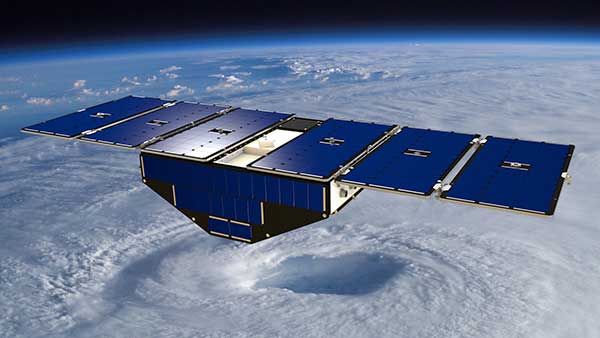
Artist’s concept of one of the eight CYGNSS satellites in orbit. (Image: NASA/University of Michigan)
Since Nov. 26, NASA’s Cyclone Global Navigation Satellite System (CYGNSS) team has not been able to make contact with one of the eight CYGNSS spacecraft, FM06.
The team is still working to acquire a signal and establish a connection.
The other seven spacecraft continue to operate normally and have been collecting science measurements since the FM06 anomaly.
CYGNSS is a constellation of eight small satellites taking measurements of ocean surface winds in and near the eye of the storm throughout the lifecycle of tropical cyclones, typhoons and hurricanes.
If the team isn’t able to reestablish contact, loss of the FM06 satellite would primarily affect the constellation’s spatial coverage. However, the CYGNSS constellation can continue to meet its scientific requirements and objectives.
CYGNSS was launched Dec. 15, 2016, and completed its prime mission science objectives on March 19, 2019. It has been operating in extended mission status since then.
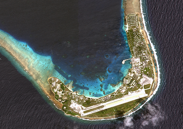
Modernized communications lines were installed at seven locations worldwide in an overhaul of the global communications network that provides command and control of the GPS constellation.
Kwajalein Atoll in the Marshall Islands is one of seven locations that received a GPS communications network overhaul.(Photo: USGS)
From 2018 to 2022, GPS Product Support Delta — in conjunction with the Defense Information Systems Agency (DISA) — performed a complete overhaul of the global communications network required to provide command and control of the GPS satellite constellation. GPS Product Support Delta is under Space Systems Command of the U.S. Space Force.
The project, called GPS Operations Network Enhancements (GONE), connected multi-protocol label switching internet protocol (IP)-based routers to modernized communications lines at seven key GPS facilities, replacing older serial lines.
“With the GONE project completed, we are seeing a 75 percent reduction in communication line interruptions.”
The GONE initiative “has significantly enhanced communications for GPS weapon systems,” said Brian Botka, Product Support Delta GPS program manager.
“These upgrades not only increase communications speed and reduce overall down-time and adding a new paradigm in network resiliency with the networks capable of recovering in mere seconds from an outage or issue,” said Sean Foley, DISA technical project manager. “The system upgrades will continue to improve service to the warfighter as well as enable increased resiliency and network diversity for DISA.”
The modernized communications lines were installed at
Schriever Space Force Base, Colorado
Vandenberg SFB, California
Cape Canaveral Space Force Station, Florida
Facilities in Hawaii, Ascension Island, Diego Garcia and Kwajalein Atoll.
Throughout the COVID-19 pandemic, many of these locations were under strict lockdown or required long quarantine periods, making coordination and travel to remote locations more challenging.
Lockheed Martin was the contractor who supported Product Support Delta GPS on the GONE project. “This was a collaborative effort with Product Support Delta GPS and DISA that required significant logistical efforts due to the COVID-19 pandemic,” said Christina Mancinelli, Lockheed Martin GPS Ground Programs director.
“With the GONE project completed, we are seeing a 75 percent reduction in communication line interruptions, and we expect that metric to continue to improve,” Mancinelli said. “The migration of the GPS communication lines to the modern MPLS [multiprotocol label switching] routers and Ethernet-based connections continues the significant improvements in GPS ground capability, cybersecurity and reliability.”
SSC is the USSF field command responsible for rapidly identifying, prototyping, and fielding resilient space capabilities for joint warfighters. It delivers sustainable joint space warfighting capabilities to defend the nation and its allies while disrupting adversaries in the contested space domain.
SSC mission areas include launch acquisition and operations; space domain awareness; positioning, navigation, and timing; missile warning; satellite communication; and cross-mission ground, command and control and data.
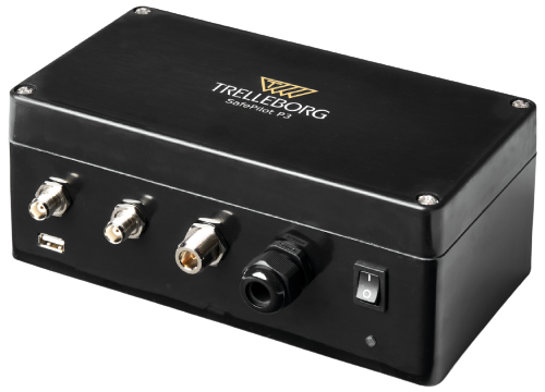
On Dec. 15, Trelleborg Marine and Infrastructure released SafePilot P3, a navigation system that meets Panama Canal Advisory (ACP) standards, which go into effect late next year for Neopanamax vessels. The navigation system provides real-time data on vessel positioning and movement in tight waterways.
SafePilot P3 operates on motion sensors and two GNSS antennas to measure the position and heading of vessels in three dimensions, minimizing time and difficulty associated with piloting procedures. SafePilot P3 has a backup battery to maintain functionality in the event of a power outage.
Image: Trelleborg SafePilot P3
This navigation system improves situational awareness while navigating waterways and ports globally, as it integrates with the ACP-approved Trelleborg SafeCaptain App. It also enhances communication between the captain, pilot, tug operators and canal personnel while vessels are transiting the canal and approaching the port.
SafePilot P3 is an addition to Trelleborg’s SafePilot portable navigation systems, which provide ports with real-time navigation information while giving pilots greater control and accuracy when approaching ports and performing intricate maneuvers.
The South African National Space Agency (SANSA) launched the South Africa Space Weather Center at Hermanus in November to provide real-time space weather forecasts. The space weather center detects space weather conditions such as strong solar flares that could disturb Earth’s magnetic field and severely affect ground-based electrical and electronic systems.
The space weather center collects data in real-time from solar satellites and a ground-based instrumentation network which consists of three kinds of sensors: GNSS receivers, magnetometers and an ionosonde system. Space weather conditions are then broadcast to South Africa and the rest of the continent to provide critical 24/7 space weather alerts for airlines, air traffic control agencies, telecommunications companies and satellite operators.
The International Civil Aviation Organization now recognizes the space weather center, as the launch filled the void in global space weather monitoring and 24/7 forecasting coverage.
SANSA received approval for the space weather center in 2019 and overcame many challenges during its development, such as limited funding for research, personnel, and equipment, as well as the COVID-19 pandemic.
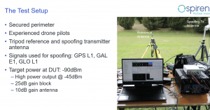
As drones are becoming a popular mode of delivery, surveillance, inspection, and mapping, they need to be resilient to spoofing. On Dec. 15, Septentrio hosted a webinar about detecting, mitigating, and protecting against spoofing on UAV autopilots.
Topics discussed included how GPS/GNSS technology fit into the autopilot ecosystem, signs of GPS spoofing and UAV vulnerabilities, realistic demonstrations of spoofing, how to mitigate spoofing, and autopilot compatibility with resilient GPS modules.
Wim De Wilde, R&D Team Leader at Septentrio, facilitated a presentation on vulnerabilities of UAVs. It included detecting signal anomalies and inconsistencies in GPS receivers to flag spoofing, technology used to spoof or hijack drones, and recommendations to prepare autopilots before take-off.
The next presentation, by Ramon Roche, General Manager at DroneCode Foundation and PX4 Autopilot, explained PX4 products that have built-in resilient GPS receivers. Greg Lopes, Hardware Design Engineer at Zipline, further elaborated about the importance of having robust, resilient GPS receivers to mitigate spoofing as it relates to Zipline’s delivery drones.
Figure 1
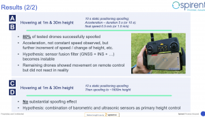
One of the final presentations was a case study of an in-field simulation and spoofing test by Jack Ackermann, Director of Product Line Management at Spirent. The case study preparation and test results that were discussed in the webinar can be seen in Figures 1 and 2.
Septentrio holds frequent webinars, with knowledgeable guest speakers, regarding topics related to GPS/GNSS technology. Find previous webinars and learn about upcoming ones here.
M3 Systems Belgium’s Haps-Augmented Search-And-Rescue Demonstrations System (HASARDS) project is looking to improve positioning of the global collaborative Copas-Sarsat search-and-rescue system by using its high-altitude platform system (HAPS).
The project is designing features for the system, such as carrying out geolocation with HAPS imagery and establishing communication between individuals in distress and emergency services.
While conducting HASARD, researchers were able to document system enhancements, execute a piloted flight-test campaign to create a realistic distressed aircraft carrying a second-generation beacon and future HAPS, and develop and operate a second-generation beacon signal simulator and HAPS system simulator.
Researchers found that using HAPS independent of Cospas-Sarsat adds value to search-and-rescue operations, providing location details via data fusion and georeferenced imagery while relaying communication between SAR teams and people in distress.
By all accounts, it is getting worse. Hundreds of internet sites sell inexpensive devices to interfere with GPS and other GNSS signals. Estimates place the number of devices extant in the United States in the tens of thousands or more. Studies show accidental interference happens about ten times more often than deliberate jamming.
In January a high-power signal in the Denver area impacted GPS reception across 4,000 square miles of airspace. The source was located, and the signal terminated after 33 hours.
October saw a similar event near Dallas that lasted for 44 hours before it ended on its own. The source of that signal was never identified.
The United States spends more than $2 billion a year to operate, maintain, and refresh GPS. Its positioning, navigation, and timing (PNT) services underpin virtually every technology, every facet of the economy. Yet, as was dramatically demonstrated at least twice this year, the nation does not have the ability to quickly characterize, locate and mitigate even the most powerful jamming signals.
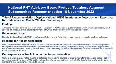
The group’s most recent recommendation is to implement a detection network based on crowdsourcing and smart phones. This would be done in collaboration with wireless service carriers.
Yet cooperation of wireless carriers, while helpful, may not be necessary, according to at least some experts.
Dr. Dennis Akos of the University of Colorado has developed an app for Android smart phones that enables devices to detect and automatically report interference with GPS and other GNSS signals. The app uses four detection methods based on location data already used by Android devices. These are comparing GNSS and network locations, checking the Android mock location flag, comparing the GNSS and Android system times, and observing the automatic gain control (AGC) and carrier-to-noise density (C/N0) signal metrics.
Commenting on Akos’ work, GNSS expert Logan Scott suggests that the U.S. government could use this new capability to establish the first phase of a national GPS/GNSS interference detection network with very little cost or effort.
“The US government provides managed phones to many government employees,” he said. “Having an app like Dennis’s operating on an opportunistic basis, [only when GPS is on in the phone] would give access to millions of phones as observers. Bottom line, the US could stand up a national observation network on an accelerated timeline, understand the nature of the threat, and avoid the embarrassments of [events such as those that occurred at] DIA [Denver International Airport] and DFW [Dallas Fort Worth airport]. And it would not cost much.”
If an effective system of some sort is not implemented, American lives and property will be at continued and increasing risk. In the words of the Advisory Board recommendation:
Dr. Dennis Akos. Image from University of Colorado’s website.
“Without a reliable, automated means of detecting and locating sources of GNSS interference, space-based PNT applications, and the general U.S. public, will continue to be plagued by potentially life-threatening and/or costly service disruptions that take days or weeks to resolve.”
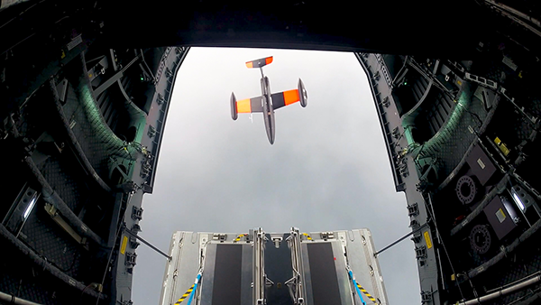
Germany has successfully launched the Future Combat Air System (FCAS) Remote Carrier demonstrator, released by an A400M.
The launch was carried out by the Bundeswehr Technical Center for Aircraft and Aeronautical Equipment (BAAINBw) and the German Aerospace Center (DLR), with collaboration from Airbus and German companies SFL and Geradts.The Remote Carrier demonstrator — an altered Airbus Do-DT25 drone — was launched from a device created specifically for the A400M to release remote carriers.
After the remote carrier was launched, its Do-DT25 engines were ignited, and it continued to fly. Controls from the A400M were then handed to the ground operator who landed the drone successfully.
As a part of the launch, the A400M was also evaluated to determine its role in FCAS to serve as a UAV launcher. Because the launch results were successful, Airbus is aiming to have the multi-role air lifter serve as the host of remote carriers.
The remote carriers and A400Ms will have an integral role in expanding the use of unmanned systems by Airbus’s military transport aircraft in the FCAS.
San Francisco local officials are questioning the safety of autonomous vehicles (AV), also known as self-driving cars, due to frequent reports of traffic violations, delaying public transportation and emergency vehicles, causing traffic congestion as well as driving onto public sidewalks.
California officials granted the first AV deployment permits this year, allowing companies to release self-driving cars onto city streets and to provide passenger service as robotaxis. Since granting permits to AV companies such as Waymo and Cruise, self-driving vehicles have been creating a multitude of issues with public safety, including a recent incident of a Cruise AV stopping a bus on its route for over seven minutes.
As state governments have the legal power to grant permits to AV companies to conduct testing and ride hail services, city officials are left powerless to control self-driving car incidents that affect residents and public safety. City officials also struggle to obtain information regarding AV-induced road blockages and even a comprehensive list of all companies have deployed self-driving vehicles onto their roads.
The White House is drafting an executive order that would simplify the approval for private launches by clarifying space rules and regulations for private American space companies. This order, which President Biden could sign into law early next year, aims to simplify licensing procedures in accordance with existing federal space laws to routinize space activities, including launching rockets and satellites deployed by private companies. Private space companies such as Elon Musk’s SpaceX and Jeff Bezos’ Blue Origin, are preparing to invest in several projects over the next decade, such as Blue Origin’s Orbital Reef project, which would build a commercial space station in low-Earth orbit (LEO).
Additionally, an online tool is being designed for the Department of Commerce to guide private companies through the licensing requirements from the relevant federal agencies. The order may also include granting certain federal agencies oversight of space activities that are not currently monitored, such as asteroid mining and space junk removal.


