The Carbonix Volanti vertical take-off and landing (VTOL) drone. (Photo: Carbonix)
Fugro is partnering with Australian drone manufacturer Carbonix to establish a new long-range drone capability. It is Fugro’s first partnership working towards long-range beyond-visual-line-of-sight (BVLOS) missions, bolstering Fugro’s existing geographic information system (GIS) capability.
Carbonix will supply Volanti and Ottano vertical take-off and landing (VTOL) drones over the next 27 months, to further enhance Fugro’s remote operations.
Fugro is engaged in the transition to remote and autonomous operations with a global network of nine remote operation centres (ROCs). From these centers, Fugro operates boats and other vehicles, and provides survey, inspection and piloting services to the global maritime industry.
Carbonix will support Fugro’s Australian long-range maritime and land projects from the sky, using aerial surveying and data-capture technology, while integrating with Fugro’s ROCs for the joint development of systems technology and capabilities.
A team of researchers has developed a low-cost sensor that can detect the changes in river height to provide wide-area flood warnings.
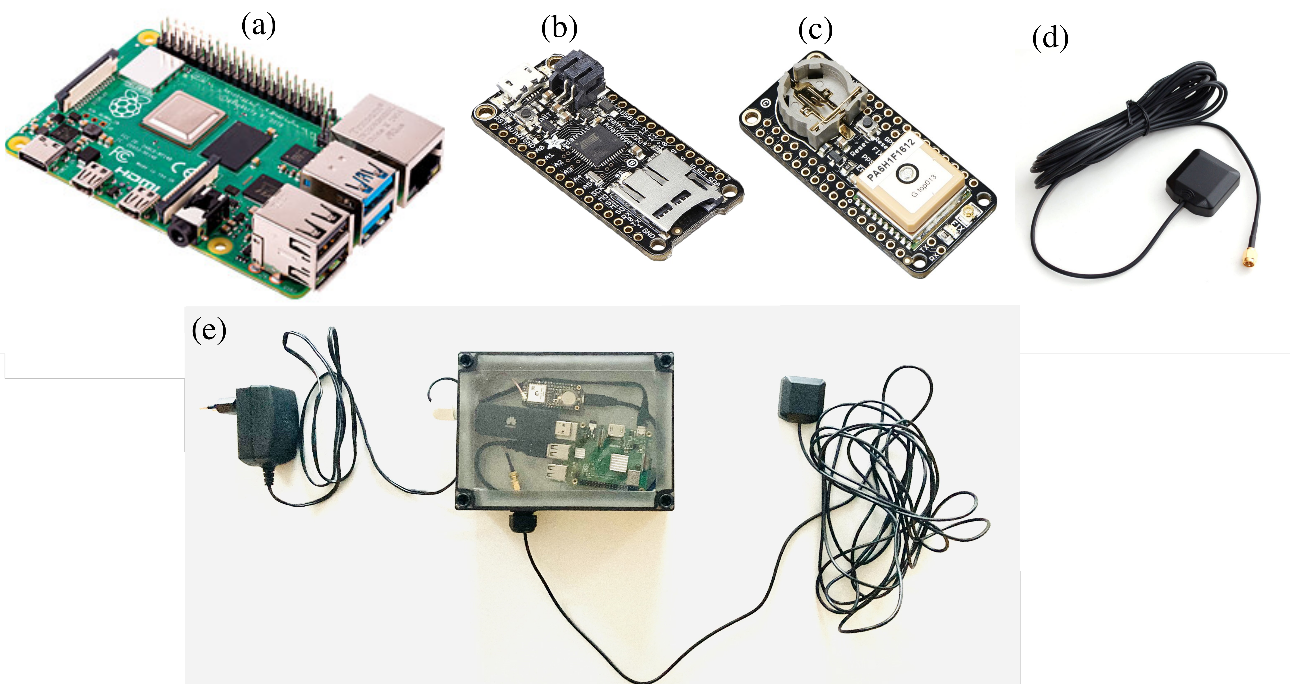
The Raspberry Pi Reflector (RPR) was designed by a team of scientists from the University of Bonn, the Federal University of Rio Grande do Sul, and the University of Colorado.
The solar-powered RPR is much less expensive (about US$150) than scientific-grade or geodetic GNSS instruments — the cost of which is “a limiting factor for their prompt and more widespread deployment as a dedicated environmental sensor,” the team writes in their paper.
The Raspberry Pi Reflector (RPR) prototype includes a low-cost and low-maintenance single-frequency GPS module (an Adafruit GPS FeatherWing receiver) and an unspecified GPS antenna connected to an inexpensive Raspberry Pi microcomputer. One such unit has been successfully operating since March 2020 in Wesel, Germany, next to the Rhine river.
The RPR hardware array: (a) Raspberry Pi 4 Model B (b) Adafruit Feather Adalogger microcontroller (c) Adafruit GPS FeatherWing receiver (d) GPS external antenna (e) Configuration of RPR prototype setup. (Image: Karegar, et al)
The unit on the Rhine provides sub-daily and daily water levels retrieved using spectral analysis of reflection data, or GNSS-reflectometry. The river level measurements from the RPR are compared with a co-located river gauge.
By changing the orientation of the antenna from upright to sideways facing the river, which was done in August 2021, the root-mean-square error (RMSE) was lowered to from 7.6 cm to 3 cm (sub-daily) and 6 cm to 1.5 cm (daily), the team said.
“While satellite radar altimetry techniques have been utilized to monitor water levels with global coverage, their measurements are associated with moderate uncertainties and temporal resolution,” the team states. “Therefore, such low-cost and high-precision instruments can be paired with satellite data for calibrating, validating and modeling purposes.”
Advanced Navigation, a developer of AI robotics and navigation technology, has raised $68 million in a Series B funding round. The Series B round was led by global investment firm KKR.
The funding round includes participation from new investors such as deep learning venture firm AI Capital and existing investors, including Main Sequence, the Hon. Malcolm Turnbull AC, In-Q-Tel, and Our Innovation Fund, bringing Advanced Navigation’s total amount raised to more than $85 million.
Advanced Navigation supplies solutions to some of the world’s largest tech companies, such as Fugro, NASA, Tesla, Google and Boeing. The funding will be used to develop AI technologies and expand autonomy beyond its current scope, including solutions to help guide driverless vehicles, flying taxis, space crafts, drone deliveries, autonomous farming and deep sea robotics. The company will also assess inorganic growth opportunities to incorporate new technologies and products into its suite which complement the company’s existing products and areas of expertise.
Louis Casey, KKR’s growth technology lead in Australia, New Zealand, and Southeast Asia, said, “Advances in autonomous navigation technology that leverages AI to reduce sensor cost while improving performance can rapidly increase enterprise and consumer applications globally. We are very pleased to work alongside the Advanced Navigation team to support the company’s growth.”
In addition, Louis Casey and Vance Serchuk, Executive Director of the KKR Global Institute, will join Advanced Navigation’s board of directors. General David Petraeus (U.S. Army, Ret.), Partner, KKR and Chairman of the KKR Global Institute, will chair a new advisory committee that targets to support the company’s global expansion efforts.
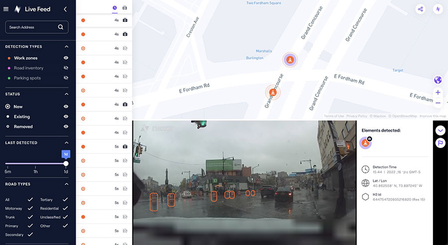
The new platform is designed to provide fresh data on nearly every road across the U.S. at a reduced cost
Nexar, an artificial-intelligence (AI) computer vision company, has released CityStream Live, a real-time mapping platform.
CityStream Live enables the mobility industry, including connected vehicles, maps, mobility services, digital twins or smart city applications, to access a continuous stream of fresh, crowdsourced road data. Only with real-time data can vehicles really know what’s coming their way, react to varying speed limits, avoid work zones, find parking and someday drive themselves. Thanks to Nexar’s massive network of “eyes on the road,” edge AI and change-detection capabilities, CityStream Live is already available to industry design partners.
Today’s digital maps often fall short of the freshness and precision that software-driven auto OEMs, autonomous vehicles, and mobility players require. Standard mapping methods — SD, HD and traffic maps — fail to provide accurate, up-to-date and cost-effective solutions, Nexar said.
To solve this problem, CityStream Live provides real-time mapping technologies at the edge of the network, enabling detection of work zones, road sign changes, potholes and free parking spaces. The platform is designed to provide fresh data on nearly every road across the United States at a dramatically reduced cost.
CityStream Live uses a crowdsourcing network and edge AI software to provide developers with a live data feed to increase situational awareness, enhance driving capabilities, increase safety, add comfort and help solve everyday mobility challenges.
More than 700,000 vehicles are in in Nexar’s camera network, which captures 94% of U.S. roads each month. Nexar collects 3 billion miles of road vision data per year.
A free trial version of CityStream Live can be accessed here.
Swift Navigation has expanded the capabilities of its Skylark precise positioning service to several product tiers. With new services providing real-time kinematic (RTK) and differential GNSS (DGNSS) options, Swift meets the broadening needs of its growing customer base.
In addition, new BeiDou signal support and regional coverage has been added.
Skylark is Swift’s cloud-based GNSS corrections service designed to deliver affordability, high accuracy and fast convergence, eliminating the complexity of deploying and maintaining GNSS networks. The expansion of Skylark’s capabilities makes it possible for customers across industries to benefit from seamless corrections to applications across the globe, the company said.
Skylark RTK delivers Swift’s highest tier of performance to third-party GNSS receivers. Compatible with leading RTK receivers on the market, Skylark RTK delivers corrections for applications that require sub-2 cm accuracy, including agriculture, machine control, drones and robotics in the United States, Europe and select Asian countries.
Skylark DGNSS is suitable for mobile applications, delivering real-time, high-reliability differential GNSS corrections to mobile handsets, positioning engine modules and mass-market applications. Skylark DGNSS enables lane-level location accuracy, in turn enabling new consumer location experiences and improving location-based services to increase efficiency on a global basis.
With BeiDou coverage already available across the United States, Japan and Korea, Swift has now added BeiDou signal support for the European Union, supplementing existing support for Galileo and GPS by providing corrections for GPS L1/L2/L5, Galileo E1/E5b/E5a and BeiDou B1/B2a. In addition, support for BeiDou B1C has been added to all regions.
These additions help support newer mass-market RTK-enabled receivers to achieve high-accuracy performance in difficult GNSS environments and continue to push the envelope for positioning accuracy.
“Swift was founded on the notion of improving GNSS positioning performance for mass-market applications,” said Holger Ippach, executive vice president of product, Swift Navigation . “We are pleased to expand the functionality of Skylark to improve the positioning functionality for many more customers across the globe.”
The suite of Skylark products was built from the ground up for scale, resilience and ease of integration. Skylark delivers seamless corrections to continents and countries across the globe including the United States, Europe, South Korea, Japan, Taiwan and Australia.
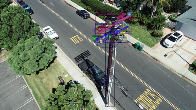
NV5 Geospatial’s distribution network data shows pole usage. (Image: Nv5 Geospatial)
Asset and vegetation management applications help utilities minimize risk and improve the reliability of electric distribution networks
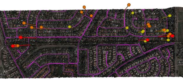
Geospatial data firm NV5 Geospatial is applying remote-sensing data analysis to improve the way utilities manage their distribution networks. The company mapped more than 5.5 million miles of utility distribution networks in the United States using a combination of lidar and orthoimagery sensors on mobile and airborne platforms to acquire data for both asset and vegetation management.
Analysis of this geospatial data enables electric utilities to minimize risk and maximize reliability, while increasing efficiency.
“An aging grid, workforce shortages, increasing energy demands and an uptick in major weather events are combining to create a perfect storm that could impact reliability, customer service and safety for electric utilities across the country,” said Eric Merten, vice president, Commercial Group at NV5 Geospatial. “A boots-on-the-ground approach to management cannot keep up with demands related to aging equipment, compliance, pole loading and vegetation encroaching on infrastructure.
“NV5 Geospatial’s innovative remote-sensing applications and data analysis tools give utilities the power to proactively address problems in their distribution network before they impact operations or customers,” Merten said.
A distribution network (purple) and vegetation risks (red/yellow pins). (Image: NV5 Geospatial)
Built on the success of its remote-sensing applications for utility transmission networks, NV5 Geospatial’s distribution management solutions offer end-to-end capabilities — from acquiring accurate, high-quality geospatial data to data analysis and visualization using custom viewers and enterprise geospatial information systems (GIS) — and can be customized to meet the use cases and budgets of utility companies.
Using NV5 Geospatial’s tools, distribution network asset managers can achieve compliance with National Electrical Safety Code (NESC) clearance guidelines, and get clear visibility into joint use of poles to prevent pirating.
The NV5 Geospatial remote-sensing data also can help quantify vegetation with distribution rights-of-way and determine risk based on proximity to wires and poles.
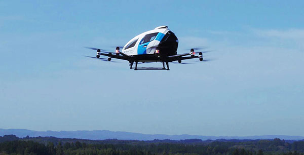
EHang deployed its EH216 eVTOL for flight trials in Europe including the recent Air Mobility Urban-Large Experimental Demonstration. (Photo: EHang)
EHang will deploy its EH216 autonomous aerial vehicle in a European Union-funded project that is assessing how the European Geostationary Navigation Overlay Service (EGNOS) could be used for electric vertical-takeoff-and-landing (eVTOL) aircraft operations.
The fully autonomous, all-electric vehicle will be used for flight trials at Lleida-Alguaire Airport in Spain as part of the Satellite Based Augmentation System Adoption in Multicopter VTOL Aircraft (SAMVA) program.
As part of an initiative of the European Union Agency for the Space Programme (EUSPA), the SAMVA project is tasked with establishing how EGNOS could support planned air mobility services, including eVTOL air taxi flights. It is also intended to prepare for uncrewed vehicles to use the new U-Space concept for managing autonomous or remotely piloted aircraft.
Aeroports de Catalunya will help China-based EHang to establish an operational center at its Lleida-Alguaire facility in the Catalonian region of northeast Spain. The EH216 will use the EGNOS technology to conduct unmanned traffic management (UTM) tasks and to demonstrate how eVTOL aircraft could operate in urban environments, including to and from airports.
EHang is working to achieve Chinese certification for the two-seat EH216, which it intends to deploy with partners and customers for services such as air taxi and sightseeing flights. It also aims to get approval for its aircraft to operate in Europe and has been active in other air mobility partnerships in Europe, where it has provisional customers in places like Norway.
In October, EHang completed its participation in the European Union’s Air Mobility Urban-Large Experimental Demonstration (AMU-LED) with a series of flight tests in Spain. The company — one of 16 consortium members in the AMU-LED program — demonstrated the EH216 at the Rozas Airborne Research Center, which is part of Spain’s National Institute of Aerospace Technology.
“The SAMVA project will unleash EGNOS capabilities aboard EHang’s EH216 AAV to provide precise and integral navigation guidance and support U-Space airspace integration,” said Victoria Jing Xiang, the company’s chief operating officer for Europe and Latin America. “Our participation in this project reflects the meaningful progress we’ve made overseas with our strong technologies as our global footprint expands.”
The agreement will enable direct access to Xplore’s satellite tasking and archive of high-resolution data
Xplore Inc., a commercial space company providing space as a service, has signed a partnership agreement with UP42, a geospatial developer platform and marketplace. The agreement will enable direct access to Xplore’s satellite tasking and archive of high-resolution data.
Xplore’s XCRAFT satellite platform is engineered to collect data with multiple instruments including still and video imagery, hyperspectral, ultraviolet and infrared spectroscopy. Xplore’s satellite is capable of achieving user-defined video flyovers.
Data generated with Xplore’s diverse sensors will address a wide variety of use cases across the Earth observation industry including agriculture, forestry, oil and gas, maritime, change detection and intelligence, and creative media content. Additionally, customers can obtain more informative, rich layers of data from Xplore’s data-fusion products.
The combined power of bringing Xplore’s high-value imagery products to market via the UP42 platform will accelerate the commercial use of private remote-sensing data, according to Xplore.
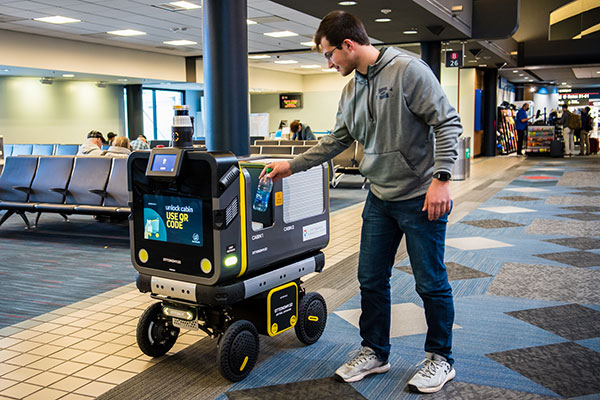
Ottonomy.io partners with Posten Norge for first-mile supply chain automation with autonomous robots
One of Europe’s largest postal services, Posten Norge, is testing the future of logistics delivery with Ottobots in Oslo.
Ottobot maker Ottonomy.io is collaborating with Posten Norge AS and Holo on trials for automating first-mile delivery in an effort to pave the way for autonomous delivery. See the project page.
The Posten Group is a post and logistics group that develops and provides post, communications and logistics services in Norway and the Nordic region. Holo is an implementer, integrator and operator of autonomous vehicles in the region.
An Ottobot delivers product orders to airport travelers. (Photo: Ottonomy)
The partnership with one of Europe’s largest logistics companies is oriented towards testing how autonomous robots can improve intra-logistics, especially in city centers. Posten Norge will be leveraging Ottobots for first-mile pick-ups, receiving and delivering goods for AMOI, a Nordic digital marketplace, from the busy Aker Brygge metropolitan area in Oslo.
“Autonomous robots have previously been tested by other companies with the focus entirely on final delivery to the customer,” said Sven Richard Tønnessen from Posten’s Department of Emerging Technology. “We want to evaluate how robots can become part of Posten’s future logistics solutions.
“This project, which utilizes both humans and robots, offers many new opportunities for increasing efficiency and productivity for our organization,” Tønnessen said. “We will continue to utilize our existing pool of human couriers for delivering goods to the customers, while the robot takes care of the intra-logistics part of the supply chain.”
Conquering the First Mile
The first mile has been a pain point for organizations in metropolitan areas. First-mile delivery involves moving products from the manufacturer’s or retailer’s warehouse to a central holding center. From this location, a carrier, shipping company or logistics partner picks up the products and takes it to the next leg in the destination.
“The logistics with delivery vans at Aker Brygge is extremely demanding in terms of parking and time consuming,” said Kenneth Tjønndal Pettersen, Posten Norge. “Together with our partners, we want to test the various applications for autonomous technology, which can enable simpler logistics and reduced noise in the cityscape.”
A recipient of the 2021 Sustainability Product of the Year award by Business Intelligent Awards, Ottobot will be used to determine how Posten Norge AS can increase sustainability and efficiency for the logistics supply chain in the future.
Speaking at the National Press Club on Nov. 3, Federal Communications Commission (FCC) Chair Jessica Rosenworcel announced a plan to reorganize the agency to include a Space Bureau and a standalone Office of International Affairs.
The rationale for these moves, as explained in a press release, is to “help ensure that the FCC’s resources are better aligned so that the agency can continue to fulfill its statutory obligations and keep pace with the rapidly changing realities of the satellite industry and global communications policy.”
While neither GPS nor Ligado were mentioned in the press release, some have taken establishment of a Space Bureau as a sign the FCC may be reconsidering its decision regarding Ligado Networks.
By creating a Space Bureau, the reasoning goes, the commission is acknowledging a need to better focus on space-based users. A report this summer from the National Academies of Science said that some GPS and Iridium users would be harmed if Ligado Networks is allowed to operate as planned.
Since the commission seems to be trying to prevent future Ligado-like controversies, it may also be ready to reconsider its Ligado decision. In February 2020 seven different petitions were filed by organizations and groups of organizations formally asking the FCC to reconsider. The commission has not yet responded to any of the petitions.
Few can disagree that aligning resources to more effective address constituent concerns is a good idea. At the same time reorganizations rarely, in and of themselves, prevent problems from recurring.
As one example, the FCC had been criticized for years for not including analyses of total costs and benefits to the nation of decisions it was considering. In January 2018, FCC Chairman Ajit Pai established the FCC’s Office of Economic Analysis to address those concerns.
Yet, despite Pai still being chair, the Office of Economic Analysis was not called upon to provide input to the commission’s deliberations on Ligado Network’s application. One of the pending petitions for reconsideration asserts that if the office had done a cost-benefit analysis, the commission’s decision would have been different. This is because the cost of even a small service degradation for potentially millions of GPS users would have very likely easily outweighed any benefit to the nation of granting Ligado Networks permission to operate.
Photo: Bill Oxford/iStock/Getty Images Plus/Getty Images
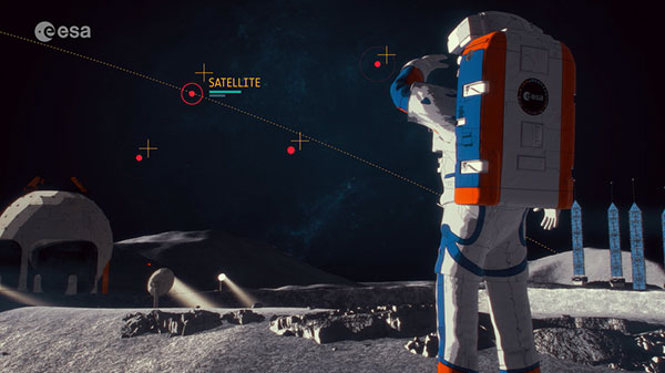
The European Space Agency (ESA) has released a new video describing the Moonlight Initiative, part of NASA’s Artemis program.
ESA is a key partner in Artemis, which aims to return people to the Moon by the end of decade. Dozens of other international public and private missions are setting their sights on the lunar surface in the coming years.
However, to achieve a permanent and sustainable presence on the Moon, reliable and autonomous lunar communications and navigation services are required. ESA is working with industrial partners on the Moonlight Initiative, to become the first off-planet commercial telecoms and satellite navigation provider.
After launch, three or four satellites will be carried into lunar orbit by a space tug, and deployed one by one to form a constellation of lunar satellites. The number and specification of these satellites are being defined.
The constellation’s orbits are optimized to give coverage to the lunar south pole, where sustained sunlight and polar ice make it the focus of upcoming missions.
Moonlight will provide data capacities sufficient to serve these planned and future missions, with a navigation service that enables accurate real-time positioning for all lunar missions.
At its meeting Nov. 2-11 in London, the IMO Maritime Safety Committee adopted a resolution to approve the BeiDou Message Service System (BDMSS) for use in the Global Maritime Distress and Safety System (GMDSS).
The GMDSS is an internationally recognized distress and radio communication safety system for certain-sized ships under the IMO Safety of Life at Sea Convention (SOLAS). The automated ship-to-shore and ship-to-ship system uses navigation satellites and terrestrial radio systems with digital selective calling technology.
The meeting summary states:
Following the assessment and evaluation of an application by China Transport Telecommunication Information Group Co. Ltd. (CTTIC) to recognize the BeiDou Message Service System (BDMSS) for use in the GMDSS, the MSC adopted an MSC resolution on Statement of recognition of the maritime mobile satellite services provided by CTTIC through BDMSS.
BDMSS was evaluated taking into account the existing requirements of the criteria for the provision of mobile satellite communication systems in the GMDSS (resolution A.1001(25)).
The recognition is currently limited to a coverage area within 75°E to 135°E longitude and 10°N to 55°N latitude.
BeiDou is the third system approved for GMDSS, following Inmarsat and Iridium, both of which use GPS and Galileo to provide tracking services.