Rx Networks, Inc., a GNSS data services company, announced the availability of TruePoint.io precise location services on Qualcomm’s Snapdragon 8 Gen 1 and Snapdragon 888 5G Mobile Platforms. TruePoint.io integration empowers Android smartphones to achieve enhanced location accuracy down to a meter or less – something previously only seen with high-grade receivers.
With enhanced location accuracy, superior user experience for such use cases as rideshare, micro-mobility, health and fitness and lane-level requirement applications can now be realized. The enablement of reliable meter-level location accuracy on mobile phones will unlock the potential of location-based services and open the door for other innovative and unique use cases. The limitations of a standalone GNSS chipset no longer become the barrier to pursuing the vision of connected ecosystems reliant on location.
TruePoint.io enables scalable, reliable, and affordable ways to leverage high-precision location on smartphones powered by Snapdragon mobile platforms. Rx Networks’ global coverage, including China, gives smartphone OEMs the advantage of a single GNSS corrections vendor that works across all continents.
“Rx Networks provision of GNSS data services for accurately positioning smartphones using Snapdragon mobile platforms will enable meter-level location accuracy almost everywhere smartphones can connect to a terrestrial cellular network,” said Francesco Grilli, Vice President, Product Management at Qualcomm Technologies, Inc. “Meter-level location accuracy is poised to improve smartphone user experiences and spur the creation of exciting and innovative services for businesses and consumers.”
TruePoint.io is scheduled to be available on Snapdragon mobile platforms initially in China in Q4 2022 and globally in H1 2023.
Leica Geosystems, a part of Hexagon, received the prestigious Wichmann Innovations Award at this year’s Intergeo in Essen, Germany, for its Leica AP20 AutoPole.
The Wichmann Innovations Award honors new technology that stands out for innovation, user-friendliness and practicality. A panel of industry leaders shortlisted the submissions. Subsequently, the public was able to weigh in by casting a vote for their favorite finalist.
The Leica AP20 AutoPole is an innovative solution for automated total stations that features tilt compensation, automatic pole height readings and unique target identification. The technological convergence in the AP20 addresses core pain points in today’s total station workflows by making it possible to measure with a tilted pole, adjust height readings in the software automatically and prevent the station from locking onto unwanted targets.
Photo: Leica Geosystems
“The Leica AP20 AutoPole boosts efficiency by removing the last analog steps in robotic total station workflows. We were pleased when customers told us they were able to double their productivity on some projects,” says Hans-Martin Zogg, business director TPS at Leica Geosystems, part of Hexagon. “This award represents the acknowledgment of the expert jury as well as the broader surveying community, and winning it is a wonderful recognition of our team’s accomplishment.”
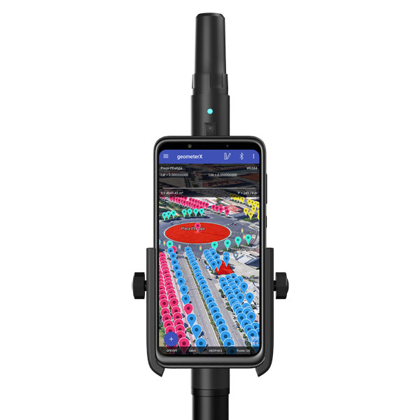
Geometer International, a Ukrainian developer of GNSS/RTK instruments and applications for satellite positioning, has introduced the Walker RTK, a dual-frequency L1, L2 RTK receiver in the compact form factor of a portable RTK device.
The Walker RTK is a lightweight, small-sized, affordable and full-featured device for collecting, storing and processing geo-referenced data on the survey site. According to the developer, a GNSS receiver in a convenient and affordable format will significantly expand the use of RTK technology. The new technology will be suited to most tasks requiring centimeter precision positioning and measurements in a 3D coordinate system.
Compact and lightweight, Walker RTK is the ideal solution for field workers working away from the office. The new device can be operated with just one hand, significantly improving the productivity of service personnel.
Possible applications for GNSS Walker RTK include surveying, utilities, solar power plant engineering, trenching and pipeline installation, drilling, forestry and municipal infrastructure control.
What’s under the bonnet of Walker RTK?
The Walker RTK is built around a 2-frequency L1/L2 184 channel board and a sensitive Helix antenna, satisfying up to 90% of basic user requirements. The tube-shaped housing geometry allows it to fit with any universal mount. The receiver weight is only 0.25g (0.470 with smartphone holder) due to the aluminum alloy housing with a protective coating. The Walker RTK has a built-in Li-Ion battery with enough power for 24 hours of continuous operation without additional recharging. The new energy-efficient architecture of the unit achieves this.
The GNSS receiver has the minimum amount of leading interfaces, resulting in high IP67 dust and waterproof rating. The device can be paired with a smartphone or tablet via Bluetooth, while connection via Bluetooth low energy is also planned for a future release.
Compatible with satellite systems
Walker RTK can track and determine geo-position using signals from all known existing satellite systems. This feature makes it possible to achieve the centimeter-level accuracy of an RTK solution within seconds.
GNSS signals processed by the Walker RTK GNSS receiver:
Thanks to NMEA messaging, the Walker RTK GNSS receiver is fully compatible with any professional or freeware geolocation software, providing high accuracy and reliable RTK-corrected positioning.
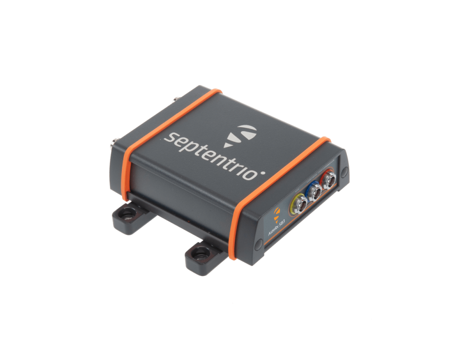
Septentrio, a leader in high-precision GNSS positioning solutions, introduced the AsteRx SB3 ProBase, the latest generation of GPS/GNSS base station receivers, designed for the creation of top-quality measurements for RTK and differential corrections.
The AsteRx SB3 ProBase is an IP68-housed GNSS base station receiver, featuring the latest quad-constellation GNSS technology for the best quality measurements. The new ruggedized receiver complements the SB3 receiver family: the AsteRx SB3 Pro, rover receiver, the AsteRx SB3 Pro+ rover and base receiver and the AsteRx SB3 CLAS, dedicated to the Japanese market.
“Customers often look for a simple, high-quality and easy-to-integrate base station to set up local high precision RTK or to densify their network and the AsteRx SB3 ProBase is the perfect solution,” said Silviu Taujan, Product Manager at Septentrio. “Thanks to its configuration flexibility and monitoring capabilities it is extremely easy to deploy and configure the SB3 ProBase. Plus, it comes with our industry-leading GNSS+ technologies, including anti-jam and anti-spoofing technology (AIM+) for unbeatable robustness and reliability.”
AsteRx SB3 products are pin-to-pin compatible with Septentrio’s popular AsteRx SB ProDirect receiver and with the recently released AsteRx SBi3 GNSS/INS system, making it simple to change receivers.
Precisely, a software company specializing in data integrity, announced that Devon and Cornwall Police leveraged its GIS software to enhance safety measures during the 2021 G7 Summit – an annual gathering of policy leaders from seven of the world’s major democracies.
The police force’s GIS team recognized that mapping software could play an important role to bring together data from a variety of sources and data formats, providing critical context in the assessment of safety protocols leading up to and throughout the Summit. The local force combined MapInfo Pro, a desktop mapping solution that provides location-based context from data, with third-party 3D visualizations to create a digital twin that enabled precise contingency planning. This model had an accuracy of up to five millimeters.
“We had two major hurdles we had to cross during the planning phase for the G7 Summit,” said Robert Goldsmith, GIS and Mapping Manager, Devon and Cornwall Police. “The first challenge was managing the sheer volume of security protocols needed for such a high-profile event, particularly given that the Summit was hosted in two locations. This meant that safety measures were required for different venues, as well as for each of the world leaders, as they traveled back and forth. The second was giving visibility to our security partners around the world, especially as the pandemic limited the ability for teams to travel to the site in the run-up to the event.”
Goldsmith and his team used MapInfo Pro to generate 2D gridded map books of the venues and enriched them with points of interest (POI) data, such as footbridges, cell masts, bus stops, and officer and partner locations. The team used aerial drone footage to build out an initial 3D model using capabilities provided by third-party providers. This was further augmented with 360-degree visualizations, using video footage that was captured by scanning more than 140,000 square meters of the Summit venues.
The resulting digital twin enabled Devon and Cornwall Police and their partners to anticipate security issues and create contingency plans using virtual reality headsets to remotely access locations during the planning phase. This removed the need to have more individuals on the ground than necessary in the run-up to the event, while still enabling highly accurate contingency planning to take place.
The G7 Summit went off without a security hitch, with GIS technology widely credited as being central to its success.
Photo: Bill Oxford / iStock / Getty Images Plus / Getty Images
TCI International, a CommTech company, announced Spectrum Surveyor, a graphical interface solution that enables radio frequency regulators to proactively monitor and manage sensors, mobile, fixed and transportable stations across their networks. The software helps regulators solve today’s spectrum management and scarcity challenges. Spectrum Surveyor is already being used by regulators in Europe.
Spectrum Surveyor helps regulators determine who is transmitting on 5G frequencies before establishing a transmission. It identifies ‘white spaces’ by conducting long-term monitoring campaigns, observation, and investigation into any existing gaps. The software enables those already operating in the 5G space to monitor more efficiently and with fewer resources, increasing the utilization of the existing monitoring network.
The new software addresses the evolving digital landscape, delivering automated and centralized monitoring of the spectrum and collecting real-time data on spectrum intelligence in the form of 3D visualizations. Spectrum Surveyor also allows teams to automate routine tasks among groups of monitoring stations, and subsequently produce reports of the spectrum’s activity, immediately flagging any issues within the network.
“In recent years with 5G adding complexity, regulators have experienced a significant increase in the number of stations needed to monitor the spectrum and the progressive intricacy of the digital landscape,” said Ann Bustamante, vice president of Business Development, Spectrum Monitoring Services (SMS) TCI. “This has led to additional considerations in the monitoring and reporting process, such as the need to centralize and simplify network control and data collection to be able to quickly identify the precise moment and location of a problem and to address it.”
Hexagon’s Safety, Infrastructure & Geospatial division announced the addition of artificial intelligence to HxGN Connect, Hexagon’s real-time incident center as a service solution.
HxGN Connect provides crime and operations centers with real-time views of different data sources, collaboration channels to coordinate across teams and the ability to add new participants and channels as needed. The AI capabilities autonomously analyze diverse data types from incidents, assets, cameras, units, alarms and more, issuing proactive notifications and alerts based on observed trends and deviations.
Having access to diverse information and intelligence in real-time enables police, emergency management, transportation and other organizations to evaluate a situation and deploy resources faster, while continuing to coordinate and dynamically respond as situations change.
“Some organizations operate in silos, without access to data or the ability to act on it,” said Kalyn Sims, Chief Technology Officer, Safety & Security, Hexagon’s Safety, Infrastructure & Geospatial division. “[HxGN Connect] breaks down silos within departments and across jurisdictions, and it mines data in real-time to deliver insights. The result is quicker and better responses to incidents and emergencies.”
Swift Navigation, a San Francisco-based GNSS tech firm, announced that it has completed $100 million in Series D Round financing. The financing round was led by SK Inc. and Potentum Partners with strong support from Swift’s existing investors. Swift’s technology powers several of the largest automotive and commercial vehicle fleets on the road today, supporting enhanced navigation and ADAS.
New investors include FM Capital, OVN Capital, TELUS Ventures, TWM Venture Co., Buckley Ventures, Schox Venture Capital and additional independent investors.
“We are delighted to be the lead investor for this financing transaction as part of our investment strategy in high-tech software companies,” said Subeom Lee of SK Inc. “We believe that Swift will contribute to advancing the new era of driverless technology.”
David Simons, founding partner of Potentum Partners, stated, “Centimeter-level position accuracy on a continent-wide scale is impressive enough, but what really excites us is Swift’s ability to provide it with extraordinary reliability, putting absolute-position data at the core of safety-critical features in automotive, automation and machine control,”
Since its Series C Round of financing, Swift has refined its global, centimeter-accurate precise positioning service and expanded its coverage across continents to meet the needs of an on-demand economy requiring higher levels of autonomy. Swift’s customers span the globe and include automotive OEMs and Tier 1s, last-mile delivery providers, mobile handset and application providers and those building rail, industrial machine control and IoT platforms for mass-market applications.
“We have an amazing group of investors behind us and are honored to see the many customers who are using Swift technology at such incredible scale as they build the future of transportation and automation,” says Swift CEO Timothy Harris. “[We thank] our loyal partners and investors at NEA, Eclipse and EPIQ and […] welcome the support of our new investors to help us deliver precise positioning across the world.”
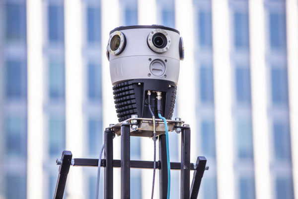
Mosaic, a geospatial imaging company, announced that its new Mosaic X high-resolution, spherical camera is now compatible with RIEGL’s mobile mapping systems.
The development of the Mosaic X focused on delivering a high-resolution, global-shutter, 360-degree camera with precise GNSS time stamping to achieve extreme visual clarity and accuracy at once. These qualities fit the requirements to be integrated with mobile laser scanning systems such as the RIEGL VMX, VMQ and VMY series.
Mobile mapping has uses across many industries and sectors, including private and public organizations. The two most consistent demands when mapping infrastructures are high-resolution, photo-realistic imagery and highly accurate data. Cameras such as the Mosaic 51 and Mosaic X capture road infrastructure with photo-realistic accuracy, which is more understandable to the human eye than a point cloud from a laser scanner.
“The pairing between 360-degree imaging systems and mobile laser scanning systems results in high precision LiDAR-based point clouds, colorized by photo-realistic images,” says Mosaic co-founder and VP of engineering, Rostislav Lisovy. “This outcome will then have the benefit of both a precise point cloud and panoramic images – for precise measurements and evaluation of textures.”
The push for sensor integration came from the customers, Mosaic CEO and co-founder Jeffrey Martin states. “We have had many requests from our customers who are looking to use RIEGL and Mosaic products in unison. The Mosaic X impresses with high-resolution panorama images and offers precisely time-stamped single-lens imagery for the purpose of point cloud coloring as well as the generation of undistorted, geo-referenced high-resolution imagery with 12 [megapixels] per lens.”
Trimble has announced Project MEP, a construction management solution that provides visibility into mechanical, electrical and plumbing (MEP) workflows including estimating, change management, project management, detailing and fabrication. Project MEP allows for greater efficiency, collaboration and visibility across projects in the electrical, mechanical, HVAC and plumbing contractors fields.
Project MEP manages drawings, documents, budgets and field productivity while extending construction management workflows with a suite of capabilities including estimating, submittal management and fabrication collaboration. The solution also provides project managers with the tools to identify issues faster, reduce rework and deliver more profitable projects. Project MEP is available as part of Trimble’s cloud-based construction management platform, Trimble Construction One.
“MEP project managers are closely involved with every detail of a project from bid to closeout, but in today’s construction environment the data they need isn’t always readily available,” said Lawrence Smith, vice president of Trimble Construction Management Solutions. “With Project MEP, Trimble is breaking down information silos … while also providing the tools project managers need to run a job more efficiently. Now MEP contractors have a construction management solution that gives them the big picture of project health and the ability to track details such as the status of a spool.”
Project MEP addresses MEP workflows including bid turnover, model collaboration, submittal management, design to fabrication, model-based estimating and field-to-office.
A roundup of recent products in the GNSS and inertial positioning industry from the October 2022 issue of GPS World magazine.
OEM
Software
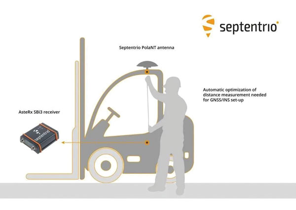
Aids GNSS/INS installation
Photo: Septentrio
The RxLeverArm software tool aids integration of GNSS receivers that include inertial navigation systems (GNSS/INS). RxLeverArm is part of Septentrio’s RxTools software package included with every Septentrio GNSS/INS receiver. The new tool visualizes, validates and automatically calibrates the exact distance between the INS sensor and the antenna, removing the need for accurate distance measurements with complex instruments. For lever-arm compensation, users only need to measure the rough distance between the INS sensor and the main GNSS antenna reference points on the vehicle. Data is then logged under open-sky conditions, which allows the RxLeverArm tool to optimize the initial rough distance measurement and prevent common errors such as sign inversion.
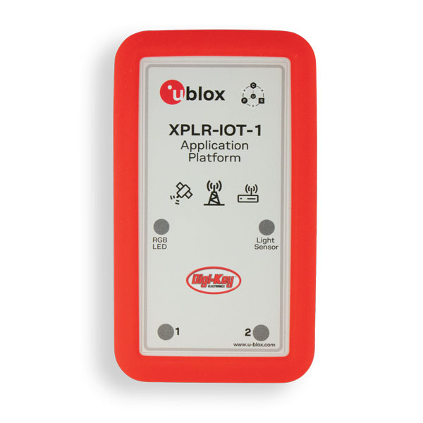
Enables proof of concept for IoT products and applications
Photo: u-blox
The u-blox XPLR-IOT-1 IoT explorer kit is an all-in-one package to test, evaluate and validate applications for the internet of things (IoT). The board hosts an ultra-low-power MAX-M10S positioning module capable of concurrently tracking four GNSS constellations, delivering highly reliable location data. Integrating relevant u-blox technologies and services into a capable prototyping platform with a vast selection of sensors and interfaces as well as cloud connectivity, XPLR-IOT-1 makes it easier to explore the potential of IoT applications.
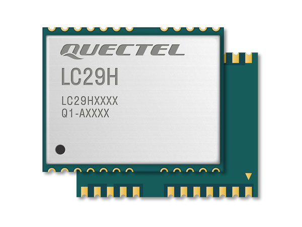
The LC29H is a dual-band multi-constellation GNSS module built using the Airoha AG3335 platform. It is available in multiple variants and optionally integrates real-time kinematic (RTK) and dead reckoning. The LC29H series offers high performance with power efficiency to meet the market needs of high-precision positioning at the centimeter and decimeter levels. The LC29H concurrently receives and processes signals from GPS, GLONASS, BeiDou, Galileo and QZSS. The modules are suited to an expanding market for autonomous lawn mowers, drones, precision agriculture, micro-mobility scooters and delivery robots.
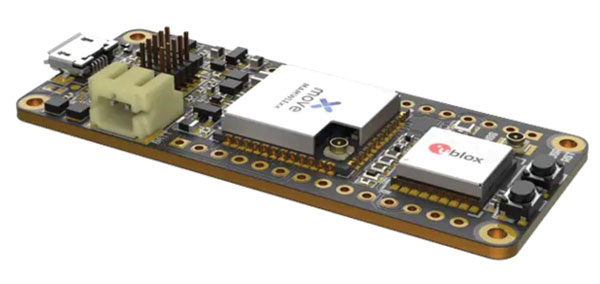
The Cicerone LoRa/GNSS board is a high-performance, low-power, Arduino MKR-compatible development board based on the u-blox MAX-M10S GNSS module and the MAMWLE LoRa module. It delivers high-performance GNSS, long-range wireless connection, and high-performance processing in a low-power solution for optimal battery life. The board allows users to build tracking applications worldwide with meter-level accuracy and to communicate long-range, low-power data via LoRaWAN. The integrated Li-Po charging circuit enables the Cicerone board to manage battery charging through the USB port. It has a compact 63 mm x 25 mm form factor and is compatible with all Arduino MKR shield boards. These boards all share a common pinout to enable developers to easily add expansions with minimal software changes.
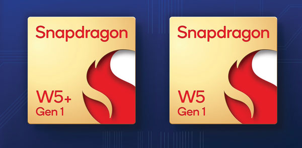
The Snapdragon W5 Gen 1 and W5+ Gen 1 platforms are designed to advance ultra-low power and breakthrough performance for next-generation connected wearables with a focus on extended battery life and premium user experiences. They incorporate innovations including low power islands for GNSS, Wi-Fi and audio; ultra-low power Bluetooth 5.3 architecture; and low power states such as Deep Sleep and Hibernate. New enhancements to the flagship Snapdragon W5+ platform offer 50% lower power, 2x higher performance, 2x richer features, and 30% smaller size, compared to the previous generation. The purpose-built platform is comprised of a 4 nm-based system-on-chip and 22 nm-based highly integrated always-on co-processor. By using these platforms, manufacturers can scale, differentiate and develop products faster in the continuously growing and segmenting wearables industry, Qualcomm said. Qualcomm also announced two reference designs from Compal and Pegatron, which showcase the capabilities of the platform and the company’s collaboration with ecosystem partners, helping customers develop products faster.
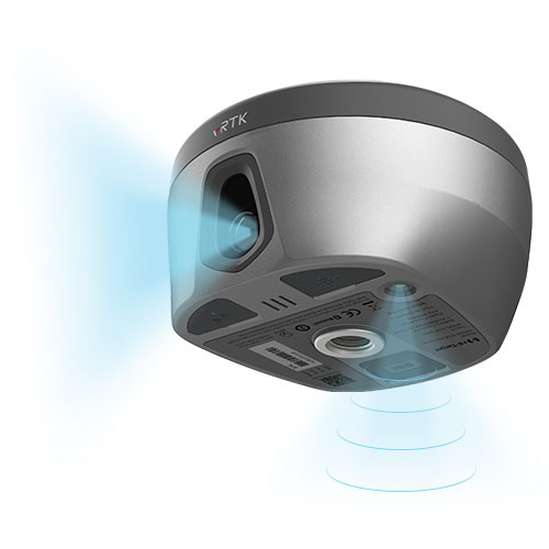
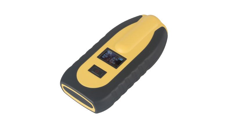
The pocket-sized vRTK GNSS real-time-kinematic (RTK) receiver is equipped with dual cameras to enable non-contact image surveying. It also has a nine-axis IMU module with auto installation for tilt surveying. Visual positioning technology combines imagery with high-precision positioning equipment, allowing users to obtain the location of the target from a distance. The Live View Stakeout function improves stakeout speed, while non-contact measurement greatly improves the usable range of GNSS. The vRTK receives 1,408 channels (GPS, GLONASS, BeiDou, Galileo, QZSS, IRNSS and SBAS). A new generation of GNSS engine supports the new frequency points B1C, B2a and B2b RTK decoding of BeiDou-3 satellites.
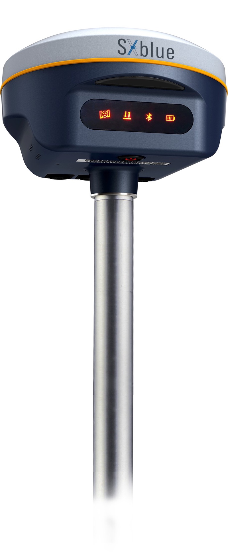
The SXblue SMART features an engine capable of tracking all-in-view GNSS signals, with interference mitigation and optimization for handling a wide frequency band. Weighing 850 g including battery, the SXblue SMART is compact and rugged. Its radio link is based on the Farlink protocol that allows a range of up to 8 km while reserving a wide bandwidth for transmission of real-time kinematic (RTK) data. In addition to a tilt sensor for measurements in hard-to-reach places, the SXblue SMART features a high-performance attitude measurement module that can detect and measure movement of the device. Also integrated are an inertial measurement unit and a thermometer for monitoring and controlling its internal temperature.
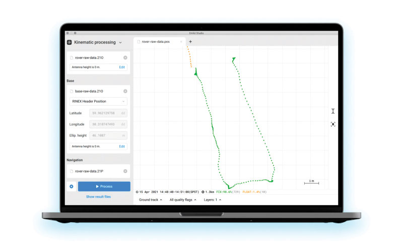
Emlid Studio is a new post-processed kinematic (PPK) application designed specifically for post-processing GNSS data. It allows users to convert raw GNSS logs into RINEX, post-process static and kinematic data, geotag images from drones (including DJI brand), and extract points from survey projects completed with Emlid’s ReachView 3 app. With Emlid Studio, users can post-process data recorded with Emlid Reach receivers and other GNSS receivers or NTRIP services. Post-processing requires RINEX observation and navigation files. Raw data in UBX and RTCM3 format also can be used through conversion.
The P1 GNSS receiver has a high-precision module that tracks GPS, GLONASS, BDS, Galileo, QZSS and SBAS to deliver centimeter-level real-time kinematic (RTK) accuracy even in harsh environments. It is also equipped with an anti-jamming and anti-spoofing algorithm. The P1 GNSS receiver has integrated the GNSS module and GNSS antenna while keeping the device as small as a smartphone, which makes it portable enough to be worn around the neck or placed in a pocket. With 4G/Bluetooth communication, the P1 supports real-time positioning data transmission, providing users with a stable correction data steam and positioning data uploads. The P1 also can be mounted on a pole.
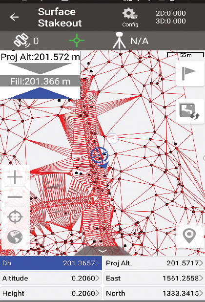
Nuwa surveying smartphone app version 2.3.3.2 has vector map import and digital surface stakeout. The Nuwa app runs on Android and is reliable and easy to operate. It has rich and powerful functions that can help surveyors complete measurements more efficiently and accurately. The app is designed to work with the David and Oscar GNSS receivers from Tersus GNSS, plus other receivers that support NMEA-0183. Features include the ability to configure base, rover and static surveys; graphical interface with background map (online/import); CAD stakeout, road stakeout and earthwork; data management (import/export multiple formats); and Bluetooth and USB connection support.
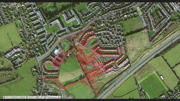
Version 3.2 of the survey application 1Edit allows the use of Web Maps (WMS) to be used as background layers, making it easier for surveyors to identify assets and changes in context. It provides easier configuration of background maps and supports hybrid working practices for surveyors. Where offline background maps are required, 1Edit supports multiple raster files and handles large image files, providing visual context for geospatial data when there is no data signal. Enhanced support for complex geometries increases efficiency as features with multiple parts share common attributes and IDs.
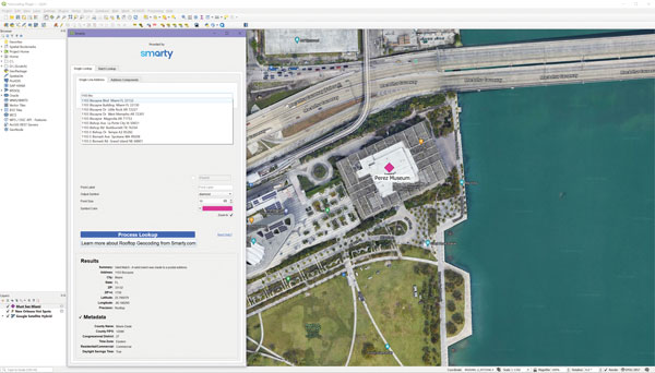
The Smarty U.S. Geocoding QGIS Plugin provides an easy way for users of the software platform to validate, standardize, and convert addresses to their latitude and longitude coordinates (geocodes). The plugin allows manual address entry as well as batch geocoding via CSV. It features a 95% match rate with the actual rooftop and parcel, as well as providing sub-address geocoding that can match secondary addresses such as apartment units and office-suite rooftops in building. The free plugin also includes supplemental metadata useful for many geographic information system (GIS) purposes.
Datasets for the United States, UK, Canada, Australia and Europe
Photo: Maptitude
Maptitude 2022 is a major release of the geographic information system (GIS) and mapping software. It includes up-to-date, accurate data encompassing expenditure, geodemographic segments, gross domestic product, medical and banking locations, branded business locations, traffic counts, building footprints, address points and financial assets, as well as the tools to leverage this information to improve the location intelligence of organizations in markets such as healthcare, franchising, communications, logistics, retail, real estate and banking.
The Mesa Pro rugged tablet features 11th-generation Intel Core processors, a Windows 11 operating system, device customization options, a large sunlight-readable display and the “Juniper Rugged” company design. Standard Mesa Pro units come with an 11th Gen Intel Core i5 processor and 16 GB of LPDDR4x RAM. Core i7 and Celeron versions are also available. Each Mesa Pro configuration offers powerful performance and allows users to select the computing performance that fits their needs and budgets.
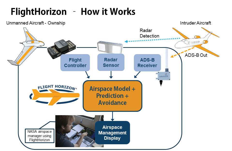
Data fusion across multiple data sources, including ADS-B
Photo: Vigilant Aerospace
FlightHorizon COMMANDER is a situational awareness and safety system for UAV airspace management. The system provides airspace managers with either a 2D or 3D view of all aircraft in the selected airspace using a combination of sensors and data sources to create an airspace safety picture for pilots, airspace managers and command centers. The system is based on an exclusively licensed NASA patent and prototype that has been used in extensive flight testing. FlightHorizon COMMANDER functions as a visualization tool for airspace management, an active situational awareness tool, and a detect-and-avoid system that enables unmanned aircraft to avoid other aircraft and keeps drone pilots and airspace managers aware of the location and air traffic around their UAS and in their airspace.
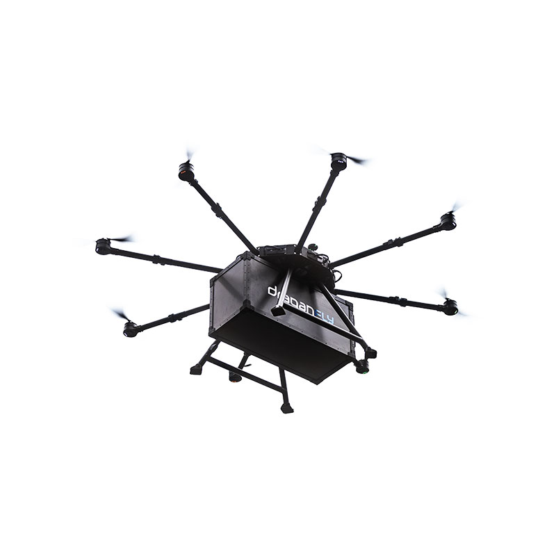
The Draganfly Heavy Lift Drone is a versatile, multi-rotor unmanned aerial vehicle designed to enhance deliveries and flight times. Compatible with a variety of interchangeable payloads, the heavy-duty drone can carry more and fly longer than the typical professional drone. It has a payload/cargo-lift capacity of 30 kg (67 lbs) and up to 55 minutes of flight time. The industrial UAV handles heavy winds and high elevations with ease. Its lifting capacity permits flexibility in carrying large high-end sensors such as hyperspectral and bathymetric lidar to conduct large-area surveys.
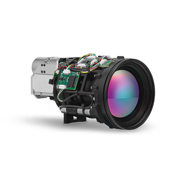
Allows rapid MWIR integration for commercial, industrial and defense applications
Photo: Teledyne FLIR
Part of the Neutrino IS series, the Neutrino LC CZ 15-300 is a new mid-wavelength infrared (MWIR) camera module with integrated continuous zoom lenses. Designed for integrated solutions requiring crisp, long-range MWIR imaging, the camera offers size, weight, power and cost (SWaP+C) benefits to original equipment manufacturers (OEMs) and system integrators for airborne, unmanned, C-UAS, security and targeting applications. The LC CZ 15-300 offers high performance, 640 x 512 high-definition MWIR imagery and 15 mm to 300 mm zoom capability for ruggedized products requiring long life, low power consumption and quiet, low-vibration operation. The camera module and lens are designed for each other, providing optimal performance.
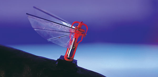
A miniature drone with flapping wings was demonstrated at the Teknofest Black Sea aviation and defense industry event, which took place Aug. 30 to Sept. 4 at the Samsun Çarşamba Airport. With its low detectability, the nano drone is being developed to perform reconnaissance and surveillance missions. It is still in research and development.
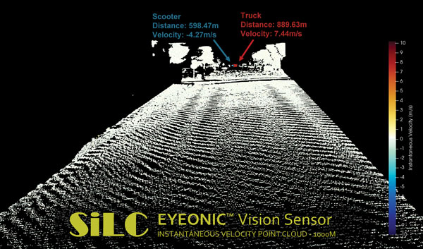
The Eyeonic Vision Sensor can perceive, identify and avoid objects at a range of more than 1 kilometer. The sensor is a frequency modulated continuous wave (FMCW) lidar transceiver that uses a silicon photonic chip. Long-range visibility is a requirement for autonomous vehicles, which require sufficient awareness to evade obstacles at highway speeds. This capability requires vision sensors to provide millimeter-level accuracy and depth at instantaneous velocity. The highly detailed and ultra-long-range information from the Eyeonic Vision Sensor enables robots to classify and predict their environments. The sensor is designed to be integrated into autonomous vehicles, security solutions and industrial robots.
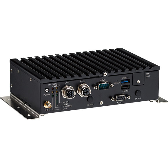
The nROK 1030 is a compact, rugged entry-level vehicle computer with an advanced GNSS receiver. The u-blox NEO-M9N module supports GPS, GLONASS, Galileo, BeiDou and QZSS signals. An Intel Atom x6211E dual-core processor 1.3 GHz/3 GHz (burst) is designed for harsh in-train environments. Its fanless, compact design is suitable for vehicles with limited space. The nROK 1030 has onboard CAN 2.0B for vehicle diagnostics and driver behavior management. WLAN Wi-Fi 6/6E/Wi-Fi 5 and WWAN 5G NR/LTE wireless data connectivity is optional. The nROK 1030 is flexible to meet the demands of various rolling-stock applications, such as wireless gateway, infotainment and digital radio data/voice transmission systems.
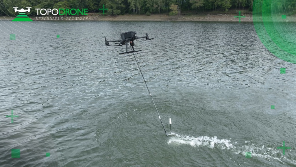
TOPODRONE, a Swiss-based designer and manufacturer of high-precision lidar equipment for installation on drones, vehicles and backpacks, launched AQUAMAPPER, a UAV-based solution for bathymetric surveying and marine construction.
AQUAMAPPER contributes to a complete set of photogrammetry, lidar and bathymetry surveying solutions from TOPODRONE. The product, compatible with the DJI Matrice 300 RTK, provides a combination of high-speed efficiency (up to 14 km/h) and accuracy mounted on a UAV. The application areas include an open sea bathymetric survey up to 100m depth, quantity survey and calculation of sediments and periodic maintenance survey of storage pools.
Photo: TOPODRONE
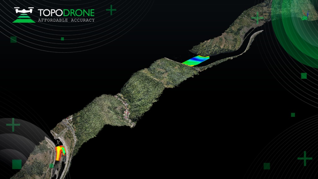
The new data-collecting device has been successfully used alongside TOPODRONE’s LiDAR ULTRA equipment for airborne surveying at a highway construction project in one of the toughest terrains in Romania, EU, including 7 tunnels, 24 bridges and 18 viaducts. The project was performed by the Romanian company GRAPHEIN TOPO SA to deliver a full digital twin of a studied area.
Photo: TOPODRONE
The TOPODRONE LiDAR ULTRA on board a DJI M300 drone was used to capture laser scanning data from an altitude of 100 m to 120 m over rugged terrain forest area to cover a corridor 32 km long and 400 meters wide in 14 flights while AQUAMAPPER connected to the same DJI M300 drone performed a bathymetric survey over six river crossings.
“The key advantage of the new bathymetric equipment from TOPODRONE is the ability to capture a riverbed with centimeter-level accuracy with high speed in fully automatic mode and without using any boat,” said Andrei Sueran of GRAPHIEN TOPO SA. “The combination of an echosounder, GNSS and inertial measurement system helps to get accurate results after data post-processing.”