Onocoy has launched a project to provide a dense network of community-powered GNSS reference stations. Based on Web 3.0 and an innovative incentive program, onocoy’s project strives to ensure outstanding positioning data quality suitable for mass market applications such as drones, micro-mobility, robotic lawnmowers or autonomous vehicles.
In the past, ultra-precise GNSS navigation with real-time kinematics (RTK) was only available to high-end markets because of prohibitive costs. With increasing demand for higher accuracies and advances in receiver technology, along with the availability of new GNSS signals, RTK receiver prices have dropped, yet high correction service costs and insufficient business models for mass markets have limited large-scale application of RTK.
Onocoy’s project aims to provide scalable correction services by leveraging Web 3.0 methods and distributed ledger technology. Such technology will facilitate a decentralized approach to the number of GNSS reference stations, 20 times the density as exist now. Ultra-dense distribution of GNSS reference stations will allow global access to instant centimeter-level positioning.
“Utilizing Web 3.0 methods with distributed ledgers and smart contracts, onocoy is poised to create the world’s densest distribution of GNSS reference stations that will enable RTK positioning anywhere,” said Daniel Ammann, initiator of the onocoy project. “By applying an open governance system, the interests of all stakeholders are taken into account in a transparent manner, ensuring that the project effectively addresses the needs of the stakeholders.”
The project will enable users to have the highest quality in GNSS data thanks to rigorous data validation and an innovative incentive scheme for data miners, where high-quality data is rewarded. Costs will be kept at a minimum with cutting-edge technology implementation and the wide user base. As a result, users will have the freedom to shape their solution to fit their market’s needs.
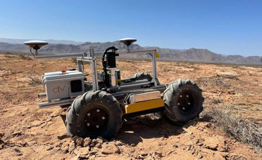
The CivDot UGV marks thousands of coordinates per day precisely and efficiently
Trimble Ventures, Trimble’s corporate venture capital fund, is investing in Civ Robotics, a San Francisco-based construction tech startup focusing on transforming surveying layout for civil engineering and infrastructure projects.
The investment supports Trimble Ventures’ mission to invest in early and growth-stage companies that are accelerating innovation, digital transformation and sustainability in the industries Trimble serves: agriculture, construction, geospatial and transportation. The investment terms were not disclosed.
The construction industry faces a variety of challenges including shortage of skilled workers, safety and productivity. Civ Robotics addresses these challenges with CivDot, a new autonomous surveying solution that empowers efficiency, productivity and safety on the job.
CivDot is an unmanned ground vehicle (UGV) designed for civil engineering and infrastructure projects such as solar farms, roadways, data centers, power plants and more. Augmenting the surveyor’s work, CivDot marks thousands of coordinates per day precisely and efficiently, while delivering layouts faster than traditional methods.
“We are focused on investing in companies that are seeking to address important challenges in markets that align with Trimble’s mission of transforming the way the world works,” said Aviad Almagor, vice president of technology innovation at Trimble and technology advisor for Trimble Ventures. “Civ Robotics technology supports surveyors and field workers and helps remove the burden of repetitive and risky work.”
Civ Robotics uses Trimble’s high-precision GNSS positioning technology and surveying software to improve productivity and increase safety, Almagor said. “This is an exciting opportunity to help accelerate innovation in autonomy, surveying and construction.”
“Trimble and our vision are in lockstep towards construction automation with a sharp focus on the highest standards of safety and quality,” said Tom Yeshurun, co-founder and CEO, Civ Robotics, which announced its $5 million seed funding round this morning. “Through Trimble’s latest GNSS technology in our autonomous surveying products, our customers can benefit from an end-to-end workflow.”
Civ Robotics will be showcased at the Trimble Dimensions+ User Conference, taking place Nov. 7-9 in Las Vegas.
The CivDot UGV, equipped with Trimble high-precision GNSS. (Photo: Civ Robotics)
An interview with Chris Trevillian, director of product management, geospatial GNSS at Trimble about recent GNSS receiver innovations.
Trevillian
What was the most significant technical innovation in your GNSS receivers in the past five years?
In 2019, Trimble broke ground with Trimble ProPoint, the fifth generation high-precision positioning engine, engineered to provide position and orientation data from the fusion of GNSS signals, globally accessible high-accuracy correction services, and measurement data from a variety of sensors.
When Trimble launched ProPoint signal processing with the Trimble R12 GNSS receiver, head-to-head testing with the Trimble R10-2 in challenging GNSS environments (near canopy and built environment) showed the R12 performed 30% better across a variety of factors, including time to achieve survey precision levels, position accuracy and measurement reliability.
In September 2020, Trimble announced the Trimble R12i GNSS receiver. It incorporates tilt compensation based on an IMU using Trimble TIP technology, which enables points to be measured or staked out while the survey rod is tilted. This empowers land surveyors to focus on the job at hand and complete work faster and more accurately.
What has it enabled users to do that they could not do before?
ProPoint provides new levels of reliability and productivity. In addition, the ProPoint engine is a key enabler of the new TIP technology.
The combination of ProPoint and TIP in the Trimble R12i allows users to accurately mark and measure points in areas previously inaccessible for GNSS rovers, such as building corners, or hazardous situations, such as the edge of an open excavation. The R12i also features real-time automatic inertial navigation system (INS) integrity monitoring. This system allows users to detect and correct for IMU biases introduced by use over time, temperature or physical shocks, helping ensure measurement quality and integrity for the life of the receiver. The combination of ProPoint and TIP technology improves accuracy, increases availability, provides better integrity and enhances constellation support.
Available on Trimble products utilizing Maxwell 7 technology, ProPoint leverages the latest developments in GNSS signal infrastructure and Trimble’s high-precision receiver hardware to deliver improved positioning performance in challenging environments. It also contains dynamic models of specific application movements, allowing it to filter out unexpected dynamic movements for improved accuracy.
What is a good example of this?
Benchmark Surveys, a small firm in Southwest England, wanted to test the R12i’s capabilities on a narrow road between an industrial park and Exeter Airport lined with high hedges, thick tangled foliage and large trees. The road-widening project, which required surveying 10 meters on either side of the road, would have been a challenge for any combination of surveying equipment. James Richards, Land, Utility and Measured Building Surveyor with Benchmark Surveys, told us the R12i was able to fix and gather points “in places not accessible by other GNSS kits we’ve used.” He said, “With the tilt compensation, we could reach under the edge of hedges and shrubs, up against buildings and walls, and safely out into the road.”
“Seen & Heard” is a monthly feature of GPS World magazine, traveling the world to capture interesting and unusual news stories involving the GNSS/PNT industry.
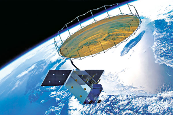
Photo: Space Norway
Norway to get radar assist
Norway’s sea areas are seven times larger than its land area. Now the country is creating a radar satellite system to surveil and locate ships in waters of interest, including the High North. On Aug. 25, Space Norway signed contracts with vendors to build the MicroSAR system, which will launch in 2025. Plans are to make a constellation of radar satellites that can detect small vessels in a large area simultaneously. While the system will use GNSS for orbit tracking, the radar function is independent of GNSS during acquisition. This will solve a flaw in the Automatic Identification System (AIS) now used for maritime surveillance — estimates are that 5% of vessels either do not send out AIS information or are transmitting false information.
Photo: Yandex
Russia’s driverless autos hit the brakes
Russian driverless projects are facing hurdles following the invasion of Ukraine, reports TU-Automotive. For instance, Russian IT giant Yandex had hoped to launch robo-taxis in the United States but has suspended street tests and robotic delivery pilots and laid off employees in its U.S. office. Russian freight carriers are experiencing a shortage of new vehicles and spare parts from Western trade sanctions and countermeasures by the Russian government. Meanwhile, Russia’s pilot tests of connected road infrastructure are still taking place, according to V2X vendor Sreda Software Solutions.
Nathaniel Frissell and team. (Photo: University of Scranton)
Bunches of grapes
A University of Scranton collaborative research project will use daily Doppler shift receiver measurements to study how dawn, dusk and solar eclipses affect the ionosphere. The team, led by Nathaniel Frissell, will use a network of GNSS-stabilized and synchronized high-frequency receivers known as Grapes, developed as part of another National Science Foundation project in 2019. The last solar eclipses to traverse the continental United States until 2044 will occur Oct. 14, 2023 and April 8, 2024. “This project takes advantage of the unprecedented opportunity to study the ionospheric impacts of the 2023 and 2024 solar eclipses and the daily ionospheric variability associated with dawn/dusk transitions,” Frissell said. A better understanding of the effects of ionospheric disturbances is imperative, because the changes affect GNSS navigation and communications systems.
Screenshot: Anonymous TV
Moscow navigation fail
The hacker collective Anonymous managed to disrupt Yandex’s Moscow taxi fleet on Sept. 1, sending dozens of taxis to an address on Kutuzovsky Prospekt. The hacking caused a two-hour traffic jam in the center of Moscow near the Stalinist-era building Hotel Ukraina (Hotel Ukraine), now a Radisson. Hackers likely bypassed Yandex’s safety measures, creating multiple fake orders that prompted drivers to simultaneously go to the same location.
Sunflowers — soniashnyk in Ukrainian — have been grown in Ukraine since the mid-18th century. Besides being a popular snack, growing the flower for export helps fuel Ukraine’s economy. Before the war, Ukraine and Russia supplied up to 80% of the world’s sunflower oil exports.
With the Russia invasion, however, sunflower and other crops have suffered, with growth of spring crops declining as much as 40% in the eastern Donbas region hit especially hard by the war.
OneSoil Map, by OneSoil, is a new, powerful data visualization and mapping tool that combines proprietary artificial intelligence (AI) with satellite imagery to map crops worldwide. It enables agricultural businesses to visualize massive datasets and deliver insights on a global scale. Another tool, the OneSoil application, helps farmers remotely monitor crop health, detect issues and apply fertilizers and seeds, increasing yields and boosting sustainable farming practices.
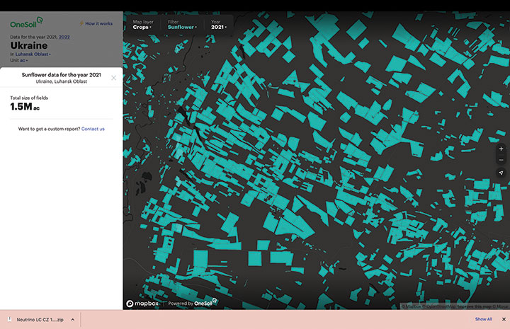
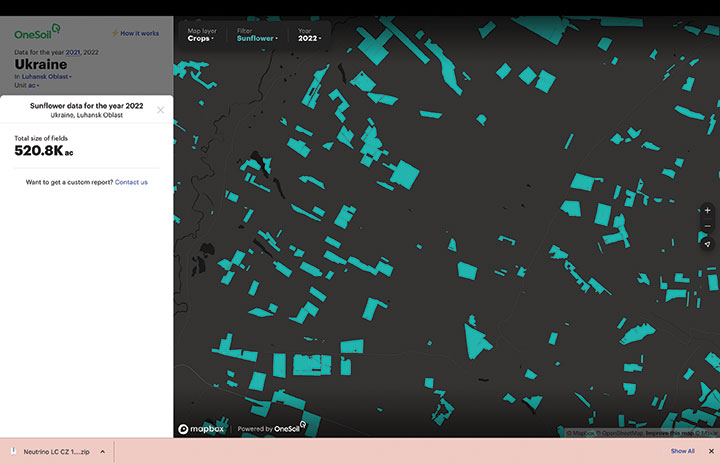
In Ukraine, satellite imagery and AI-based technologies are helping farmers face shortages and a population confronting food insecurity. OneSoil compared 2021 and 2022, and foundthe area used for the country’s spring crops— corn and sunflower— have decreased by 40% in wartorn regions, with the greatest decrease in Kharkiv (–59%), Donetsk (–58%), Luhansk (–57%) and Zaporizhia (–43%).
Corn is an export crop that accounts for 16% of the global market. OneSoil Map showed its overall acreage in the main corn production areas (Chernihiv, Poltava, Sumy) has dropped by 19% to 36%, depending on the region.
The above sample of sunflower crops in the Luhansk Oblast region — part of the wartor — shows the decrease in crop fields from 2021 (top, 1.5M acres). (Image: OneSoil)A sample of sunflower crops in the Luhansk Oblast region — part of the wartorn Donbas — shows the decrease in crop fields in 2022 (520.8K acres). (Image: OneSoil)
Trimble has released the Trimble TerraFlex Premium edition, a new tier of Trimble’s flagship geographic information system (GIS) data-collection software. The edition provides customers with offline GNSS corrections.
The new automated service works exclusively with Trimble GNSS receivers — including the Trimble DA2 receiver for the Trimble Catalyst positioning service — to provide high-accuracy GIS data capture in a wider range of locations and difficult GNSS environments than was previously possible.
TerraFlex users can increase the quality and speed of their data collection using offline GNSS corrections in situations where real-time services are intermittent or unavailable. Using the new service, all data from the field is automatically processed in the cloud without user intervention.
The most accurate real-time or offline processed position is stored for each feature, unlocking a high-productivity enhancement for all TerraFlex Premium subscribers.
Combining data-collection software and offline GNSS corrections into a single TerraFlex subscription simplifies both the workflow and the purchasing process for GIS organizations, from state and local governments to enterprise customers, including federal governments and utilities companies. This workflow to collect, process and deliver the most accurate and reliable positioning information reduces complicated manual processing steps and helps preserve data integrity.
Photo: Trimble
Streamlined post-processing using TerraFlex offline GNSS corrections is also available to Esri ArcGIS users, with the new Trimble Terra Office add-in for the Esri ArcMap GIS application. The new add-in replaces both the Trimble Positions Desktop and Trimble TerraFlex Desktop add-ins and supports offline GNSS corrections as well as existing desktop post-processing workflows. Terra Office is available as a yearly subscription.
“With Trimble offline GNSS corrections, we’ve taken the manual steps out of post-processing and made it as effortless as possible,” said Gareth Gibson, marketing director, Trimble Mapping and GIS. “This workflow enables TerraFlex customers to expand the locations and environments in which they work while still achieving high-accuracy results, and all without needing to become a GNSS expert.”
The TerraFlex Premium edition subscription is available through Trimble Geospatial Distribution Partners.
The TerraFlex offline GNSS corrections service uses a network of community base stations, and is broadly available in North America, the United Kingdom, Europe, Australia and New Zealand.
The Trimble Terra Office add-in for Esri ArcMap software is available through Trimble Geospatial Distribution Partners.
Fuel and fertilizer prices are at all-time highs, as farmers the world over are scrambling to find ways to stay financially afloat. Large commercial farms have long had a leg up over smaller holdings. They already have access to artificial intelligence (AI) and cutting-edge hardware to plan their operations and automate tasks. They run broad sensor networks to monitor soil quality, operate vision-enabled drones to monitor crop health, and let autonomous tractors steer across their fields to vastly improve their productivity.
These advanced systems have been prohibitively expensive, to the point that their costs are hard to justify for smaller holdings, less than two hectares in size, which make up the vast majority of the world’s more than 570 million farms. Many of these farmers simply don’t have access to sufficient capital to invest in new equipment, and continue to rely on older machines and human labor. For them, the vast promise of the digital revolution to increase the efficiency of agricultural operations — typically lumped together as smart farming or precision agriculture — has long remained just out of reach.
But change is in the air. Over the past few years, the popularization of the internet of things (IoT) and its underlying technologies has led to the development of a new and more affordable generation of precision farming solutions. These solutions are giving smallholdings tools to increase the quantity and the quality of their production. Combining satellite-based positioning, wireless connectivity and visual sensing with advanced algorithms including machine learning (ML) and artificial intelligence, these solutions promise to help farmers produce more for less, putting them on more equal footing with their larger commercial competitors.
In this article, we take stock of key trends driving the democratization of precision agriculture. We zoom in on some of the concrete applications transforming the operations of smaller farms the world over. We start by exploring the core enabling technologies, the applications they enable, and where they are headed.
Technological evolution on all fronts
Sensor-fusion platforms
At their heart, precision agriculture solutions are sensor fusion platforms, taking in data points from a variety of sensors, using algorithms to make sense of them, and extracting insights on which their users — machine or human — can act. As they mature, these sensor fusion platforms are becoming increasingly complex, crunching more and more types of sensor data with algorithms of growing sophistication to gain ever deeper and higher value insights.
These insights are often generated using AI and ML models that run at the edge of the network near the sensors — on the tractors, sprayers, or other devices themselves — rather than in the cloud.
Equipment manufacturers looking to integrate AI/ML at the edge are weighing their options in terms of adding application processors and hardware accelerators capable of running advanced ML models needed to fuse camera and sensor inputs to make real-time decisions. To simplify the adoption of AI/ML at the edge, many vendors are starting to integrate AI accelerators into their modules and systems-on-chip (SoCs), lowering the barrier to entry.
Original equipment manufacturers (OEMs), for their part, are choosing to integrate these SoCs even if their software capabilities are still behind. For them, building solutions with future-proof hardware is a potentially lucrative strategy for generating recurring revenues through firmware updates that provide advanced functions down the road.
Despite the abundance of evaluation kits from major vendors, scaling from prototypes to production with these solutions can be expensive. While integrated sensor fusion platforms with, for example, pre-loaded dynamic vehicle models for auto-steering or computer vision models for plant health can accelerate development for OEMs and reduce the need for software investment, they can be too generic and may not solve use-case-specific needs. More focused AI/ML may require more investment in data collection and training models, which, due to their proprietary nature could come at a higher price.
Camera systems are already widely relied on by autonomous tractors, visually monitoring the surrounding environment and feeding their data into computer-vision solutions where it is parsed. Context-rich, vision-based data can help optimize the distribution of agricultural inputs such as water, seeds, fertilizers and pesticides using real-time variable spray-rate control based on plant size and other metrics to significantly improve efficiencies and reduce overall costs.
Camera systems come with a set of challenges that need to be carefully managed. Lenses can become contaminated with water, debris, dust, and snow. Even though these issues impact all vision-based applications, including mass-market applications such as automated and autonomous driving, there are still no reliable methods of keeping them clean, aside from water-spraying nozzles (that can cause buildup on the lenses) and old-fashioned manual maintenance.
Additionally, the steep price of high-resolution cameras can drive up the cost of end solutions, as can data storage and communication when the visual data is processed in the cloud.
Global navigation satellite systems
Satellite-based positioning has also become a staple in precision agriculture solutions. Autonomous and guided tractors use the technology to drive vehicles along precise paths to increase pass-to-pass efficiency and reduce overlapping rows. Crop monitoring drones use GNSS technology to patrol predefined flight paths. And fully autonomous guided vehicles such as robotic lawnmowers use it to avoid restricted no-go zones. The latter three applications typically require centimeter-level positioning accuracies.
Centimeter-level GNSS technology has been available for well over a decade, with farmers subscribing to relatively costly GNSS correction services tailored to each user. However, it was only with the advent of affordable RTK services with availability in rural areas, as well as the dramatic decrease in cost for farmers to deploy their own RTK base stations using low-cost modules, that the price point of high precision positioning has come down far enough to make the service affordable to all but the least lucrative operations.
High precision GNSS technology brings the benefits of improved pass-to-pass efficiency – a general reduction of all agricultural inputs with all the financial, environmental, and health benefits that this entails. At the same time, it requires solutions to deal with signal delays and the resulting inaccuracies of multipath effects, caused when signals bounce off buildings, mountains, or other solid structures on their way to the GNSS receiver.
When delivered via the internet, the GNSS augmentation data stream requires an IP connection to the provider’s server. This poses challenges for farms that lack infrastructures such as Wi-Fi base stations, sub-GHz RF systems, or cellular network coverage.
Photo: Avalon_Studio/E+/Getty Images
Wireless connectivity
In some way or another, all advanced precision ag use cases depend on wireless connectivity. Environmental sensors and inspection drones need it to relay data to the cloud backend. Additionally, tractors, drones, and other farm robots depend on it to upload telematics data, report their status, enable predictive maintenance tools to reduce downtime, and receive GNSS augmentation data for high precision positioning.
While cellular connectivity is the easiest to use — all it takes to upload data straight to the cloud is a mobile data subscription and a SIM card — it has two key drawbacks. The first, mentioned earlier, is that the entire farm needs robust network coverage, which is not always a given in rural areas even in the United States and other developed countries. Also, when coverage is available, the cost of data transfers can quickly add up and become prohibitive for smaller, less profitable farms, as they may not be able to negotiate affordable connectivity plans as effectively as larger operations that have much higher data usage.
One way to address the coverage issue is by choosing the right wireless communication technology. Low power wide area technologies, such as LTE-M, NB-IoT, and Cat-1 solutions offer similar coverage to traditional LTE in many countries and are available at a fraction of the cost. When higher bandwidths are required, LTE Cat 4 or higher modules offer 150 Mbps+ of throughput. 5G modules enabling gigabit connectivity are available today, but solutions may cost up to 10-times more.
As an alternative, 5G Redcap – an upcoming 3GPP technology – seeks to provide a 5G compatible, affordable solution with medium bandwidth and lower complexity, enabling affordable hardware. We will likely start to see the first RedCap offerings from mobile network operators in 2025.
Artificial intelligence and machine learning at the edge offer an additional tool to reduce bandwidth requirements, by processing sensed data near the sensors themselves. Rather than streaming vast amounts of raw sensor data to the cloud, devices leveraging edge intelligence can reduce their wireless communication bandwidth requirements and cost by uploading only relevant information.
The trends driving democratization
Progress in sensing and sensor fusion platforms, camera systems, GNSS technology, and wireless connectivity is but one of the drivers democratizing precision agriculture. The other is an ongoing ecosystem-wide transformation that is breaking down many of the barriers that have kept precision agriculture solutions the preserve of large, lucrative farming operations.
Together, they are bringing down the cost of ownership of precision ag technology. Only just a few years ago, the only available solutions from major OEMs came with a hefty price tag, comprising expensive hardware and considerable recurring subscription fees, while requiring skilled labor to implement, operate, and maintain smart equipment.
Vendor lock-in enforced by locking telematics interface ports prevented farms from adopting aftermarket solutions — justified as a way to improve safety and vehicle reliability. Ultimately, however, this limited farmers’ ability to maintain their equipment themselves and to piece together cost-optimized solutions tailored to their specific needs using components from competing solution providers.
Today, all of this is changing. Hardware costs are down dramatically due, largely, to economies of scale unleashed by the Internet of Things’ explosive growth. Farmers now have access to affordable, user-friendly aftermarket solutions to upgrade tractors and other agricultural machines they already own that depend on a new generation of more cost-effective GNSS correction services. OEMs are introducing advanced functionality in their entry- to mid-range tractors in addition to their premium product line.
At the same time, the abundance of open-source projects, module-based solutions, and pre-certified radio technologies are making the development of precision ag solutions cheaper, bringing down the cost of off-the-shelf hardware. Add to that lower subscription costs for GNSS correction services thanks to improved broadcast distribution with SSR-RTK (state space representation-real-time kinematic).
The total cost of connectivity is dropping as well. Deploying connectivity infrastructure was long a non-negligible cost point, made up of wireless infrastructure and data subscription fees. Today, thanks to the increased availability of cost- and power-optimized wireless communication technologies with broader coverage (LTE-M, NB-IoT, LTE Cat 1), farmers can reap the benefits of the overall expansion of cellular network infrastructure.
Arguably one of the most promising trends driving the democratization of precision agriculture technology comes from the farming community itself in the form of do-it-yourself solutions based on open-source hardware and software designs.
Take AgOpenGPS, also referred to as AOG, an open-source auto-steering solution created by a Canadian farmer and software developer. AOG delivers all the hardware design files, the real-time microcontroller firmware, and software required to enable auto-steering on conventional tractors, regardless of their age. Thousands of hours invested by the AOG developer community have made the solution accessible to the masses, both financially — retrofitting tractors can cost less than USD $1,000 — and in terms of prerequisite knowledge.
A growing variety of precision agriculture platforms, from high-end commercial solutions that cater to the most profitable farms to low-cost do-it-yourself solutions that can pay for themselves in a year and are accessible to smaller, less profitable operations, are transforming the impact that precision agriculture can deliver. With the global food supply under tremendous pressure, this democratization of smart farming technology could come to play an important role in feeding the world.
To learn more about how u-blox enables high-precision autonomous vehicles and other smart farming applications, visit www.u-blox.com/precision-agriculture.
Funding continues to flow into companies developing and testing electric vertical-takeoff-and-landing (eVTOL) drones — both piloted and unpiloted.Plus, the potential for clearing landmines using drones is being investigated by a team at Oklahoma State University.
Air taxis advance with funding
In early September, United Airlines committed to a $15 million investment in Eve Air Mobility, giving the air taxi industry another shot in the arm. The deal includes a conditional purchase of 200 and an additional 200 in options for Eve’s semi-autonomous four-passenger eVTOL aircraft. The investment is one of United’s efforts toward its goal of net zero carbon emissions by 2050.
Eve Air Mobility is partnered with Embraer, the Brazilian aircraft manufacturer guiding Eve’s path to first eVTOL aircraft certification under the National Civil Aviation Agency of Brazil (ANAC). Subsequent approval by the U.S. Federal Aviation Administration (FAA) and the European Union Aviation Safety Agency (EASA) would then be based on the Brazilian ANAC certification program, following in the path of U.S. and European approvals of the Embraer EMB/ERJ series of passenger aircraft.
The Eve eVTOL air taxi. (Image: Eve Air Mobility)
Eve and parent Embraer also have announced a deal with BAE Systems to design an eVTOL aircraft for military and security applications. The technical details of the UAV/aircraft have been kept carefully under wraps, save for the visible use of eight lift rotors and two ducted fans for forward flight. Flight management computers, guidance, air-data, altitude sensors and high-integrity communications would likely be included in the avionics suite.
Meanwhile, United’s prior investment in Archer Aviation and its Maker eVTOL appears to be supporting the Maker’s progress along the road to civil certification. Maker flight tests so far have apparently been limited to vertical flight; its multiple lift and tilt-rotor design has yet to be tested in transition to forward flight.
The Maker eVTOL air taxi. (Image: Archer Aviation)
Nevertheless, more information appears to be available on the configuration of the Maker eVTOL. The company’s approach is to demonstrate early on that safety is a major driver for the design, with significant redundancy in the vehicle’s systems. The Maker has four flight-control computers, plus redundant control and navigation with inertial navigation, GNSS and above-ground-level (AGL) sensors, both radar and laser altimeters. Redundant communication links between sensors, flight-control computers and actuators combine to provide another level of design safety. The vehicle has six lift rotors at the back of the wing, plus an additional six main tilt-rotor lift and thrust rotors — another significant contribution to redundancy.
In January 2021, Archer said that United Airlines ordered 200 Maker aircraft for $1 billion with an option for more aircraft worth $500 million. Archer also just got another healthy financial injection in August with United’s pre-delivery commitment of $10 million for 100 Maker-type aircraft.
There are numerous eVTOL builders around the world. Several of note include Boeing/Wisk (U.S. and New Zealand), Joby (U.S.), Vertical Aerospace (UK), Ehang (China), Airbus (France), Lilium and Velocopter (both Germany) and Beta (U.S.).
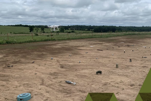
Drones help detect landmines
Its difficult to imagine the extent of the problem, but there are many, many areas of the world where landmines are a major hazard to civilian life. Eventually, wars move on or die out, with not only towns and infrastructure destroyed, but significant left-over hazards to reclaiming territory once occupied by the aggressors.
Landmines come in many flavors, but most are deadly and most kill or maim innocent people coming across them. Unexploded bombs, mortar shells and the like also can kill and hurt people, especially children. Apparently, 50 to 60 countries around the world have areas where landmines or unexploded ordnance pose a threat to civilians.
The good news is that several organizations around the world have been using drones to survey areas suspected of being mined. The organizations send drones equipped with magnetic detection sensors a few inches above the ground. The drones geotag mine locations, and those locations go into an area database. Then another drone is sent to drop a detonator on the mine location, with the mine later exploded from a distance.
An investigative team at Oklahoma State University is making an effort to train a drone-based machine-learning system to recognize various types of landmines and explosive ordinance. While the system isn’t aimed at detecting mines without human participation, it’s expected that drone recognition of mines could greatly improve current efforts to remove landmines, and quicken the pace at which the world can get rid of this plague of hidden explosives.
A drone flies over a grid showing 50 types of ordinance. (Photo: Oklahoma State University)
The research team is working in an area they have set up with inert mines of many types to train the drones to recognize the specific type of device and geotag the location. This isn’t artificial intelligence as such; it’s using drones to find an object and geotag it, while the network to which the drone is connected recognizes from the sensor data what type of mine the drone has found.
In the research phase, the team is feeding data into the network on lots of different types of mines and munitions, providing the network with a model for each type of ordinance and eventually enabling device recognition in the field.
To sum up, the rush for air taxis to become a ubiquitous resource for city travel still wends its way through the civilian twists and turns leading to civilian certification for use, with many outfits working hard to build flying testbeds and investors funding their efforts.
Finding novel drone-assisted ways to clear the millions of landmines left over in wartorn countries is becoming a higher priority — notwithstanding Princess Diana’s efforts to draw attention to the suffering and death from landmines several decades ago. Let’s hope this goes somewhere soon.
Apple co-founder Steve Wozniak will join Trimble CEO Rob Painter on the stage for the 2022 Trimble Dimensions+ keynote presentation.
Trimble Dimensions+ is a three-day user conference providing education, showcasing innovation and offering networking opportunities with Trimble users, customers and product experts from around the world. This year, the conference will be held in-person for the first time since 2018, and will be held Nov.7-9 at The Venetian in Las Vegas.
Wozniak and Painter to Present
CEO Rob Painter will kick off the conference with an inside look at how Trimble’s Connect & Scale strategy is enabling customers to do their work faster, better, safer, cheaper and greener. Connect & Scale provides innovative solutions to better connect people, technology, tasks, data, processes and industry lifecycles.
Painter will showcase transformative technologies that have had a positive impact on industries, projects and people.
Rob Painter
Painter will be joined on the main stage by Steve Wozniak, who exemplifies Trimble’s passion for innovation and technology. Like Charlie Trimble, the company’s founder, Wozniak began his career in Silicon Valley in the 1970s when he and Steve Jobs formed Apple Computer Inc.. This was was followed by the development of Apple I and II — Apple’s first line of products and integral to launching the personal computer industry.
On the Trimble stage, Wozniak will share his famed journey from computer geek to cult icon, entrepreneur and philanthropist.
The keynote will end with remarks from Aviad Almagor, vice president of Technology Innovation, who will provide a sneak peek at emerging technologies being developed at Trimble — including robotics, autonomy and artificial intelligence — and discuss how they are reshaping the future of engineering and construction.
About Trimble Dimensions
Trimble Dimensions+ user conference is a three-day, in-person event where attendees can better connect as a community for education, inspiration and innovation. The conference provides insight into how Trimble’s industrial technology can transform the way professionals work to succeed and drive sustainability.
Highlights include educational sessions and specialized tracks to advance career objectives, with many sessions qualifying for Professional Development Hour (PDH) credits and Continuing Professional Education (CPE) credits.
The conference includes
the Offsite Experience
hands-on training opportunities
keynote and executive-level presentations
an interactive Expo.
In addition to the in-person event, Dimensions also features the virtual, on-demand Spotlight Series that focuses on industry trends. The series is delivered by experts on technology transforming the way we work.
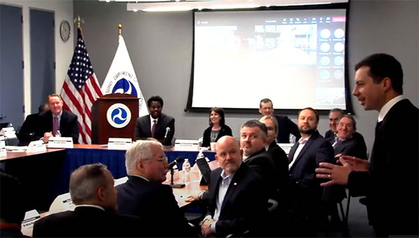
Transportation Secretary Pete Buttigieg made a surprise appearance at the DOT roundtable on complementary PNT. (Screenshot: DOT)
“If this is a problem, the government should act like it.”
Citing more than 10 years of government studies, warnings and promises, representatives from a wide variety of industries criticized the government recently for doing little to address an important national security problem.
At issue was the need for national backup capabilities for GPS and the essential positioning, navigation, and timing (PNT) signals it provides.
GPS signals are weak and easy to block or imitate. At the same time the signals are used by most technologies including networks, telecommunications, electrical grids, broadcast, mobile radios, transportation, and other critical infrastructures.
After Russia threatened to destroy all GPS satellites in 2021 in its run-up to invading Ukraine, a member of the White House National Security Council told a public meeting “GPS is still a single point of failure” for the nation.
The government was criticized for inaction at a “Complementary PNT Roundtable” hosted by the Department of Transportation (DOT) in early August. The department is the federal lead for civil GPS and PNT issues.
Eight attendees interviewed after the event reported a surprising unanimity of comments and concerns expressed by industry reps at the meeting.
Enough with the studies
A repeated theme was that the government has done enough studies to understand the problem and available technologies.
“They have been studying this for over twenty years,” one attendee observed. “The Volpe [Transportation Systems Center] report came out in 2001. And there have been lots of studies since then. All have just been refinements of those original findings.”
Another consistent theme was disdain for the idea that industry and the free market will solve the problem without government leadership and active support.
“GPS is free,” said one attendee from a company that provides PNT services. “We can and do sell to meet niche demands, but it is laughable to suggest we can ever sell enough subscriptions to be enough of a backup for GPS.”
A major telecommunications company rep echoed the sentiment. Wireless telecom is especially reliant on PNT. “We use GPS and would use Loran and low Earth orbit satellites if they were available, but we are not going to build it on our own. There is just no business case.”
“We have a big list of things we could do that would increase our resilience and/or cut costs,” said another telecom provider. “There is no big driver for most, though. No competitive pressure, no government mandates.”
Government must walk the walk
“The government has been telling us for over a decade that this is a problem,” said one attendee. “If that’s true, why aren’t they acting like it? Transportation is critical infrastructure and needs a GPS backup, for example. So why hasn’t DOT done something?” Of all the criticisms expressed, this was predominant, according to interviewees.
A 2021 Executive Order on responsible use of PNT services encouraged critical infrastructure providers to not rely on GPS.
The government needing to be a lead customer was mentioned a number of times at the event. This would help raise awareness, set an example, and signal to users the issue is important enough to act on.
Government action was also seen by users as key to creating confidence that a technology or service will be around for the long haul. This point seemed to resonate with many of the government representatives as well.
“I am not going to go to the time and expense of adopting something unless I know it is going to be around for 20 years or more. The only way I can be assured of that is if one of the biggest users is the government.”
Adversaries not idle
Of particular concern to some was that America’s adversaries have better, more resilient PNT, and are constantly working against us.
They are building PNT “…systems of systems. Space-based, ground-based, and everything in between-based. They are doing it. We need to get out in front and lead,” said one. China has been particularly active building multiple integrated PNT systems.
“Our adversaries are not stupid” and are going to try to stay in the lead. “They will try to interfere with any frequency, system, or combination of systems selected. We must test and build something that is survivable and resilient.”
“If China, Russia, and Iran had the ability to protect themselves from nuclear attack,” said one attendee, “we would be frantically trying to get the same capability. Yet those countries have backup and complementary systems for PNT, and the United States does not. And we’re not doing anything,” said a participant reflecting upon the event.
Hopeful signs
Several attendees said there were signs the event might not have been “just another government meeting.”
As part of his opening remarks, the event host, DOT Deputy Assistant Secretary Dr. Robert Hampshire, mentioned the bipartisan infrastructure law and affirmed that PNT is infrastructure. This led some to believe funding from the infrastructure legislation could be immediately available if the government decided to act.
Others were cheered by DOT Secretary Buttigieg’s cameo appearance and comments at the event. One remarked it was the first time they had heard a DOT Secretary say “PNT” in over 20 years.
Uncertain outcome
Despite the consistent messaging and potentially hopeful signs, some attendees questioned whether anything would change because of the two-and-a-half-hour event.
“There were about 120 people from industry and a wide variety of government agencies, but what was the point?” asked one. “We all told the government the same things we’ve told them before, often in writing.”
Another was concerned that the event didn’t discuss the most important questions.
“We were talking about individual systems and critical infrastructures,” this person said. “This is a strategic national security issue. We need to get the bullseye off GPS and ensure the United States can’t be blackmailed by having GPS held hostage.”
“And what if there is a major coronal mass ejection? China will come out much better than us because they have survivable PNT. The United States will become a second-rate power to China in an instant. We keep talking about the trees and ignoring the forest!”
One attendee whose company has a very active government relations program reported they hoped the event would help sway those in government still opposed to action.
“It is pretty clear to us that almost everyone in the departments who understand the issues is in favor of doing something as soon as possible. The same with Congress. But even though the National Security Council is worried about this, there are some folks in the Office of Management and Budget who have opposed action for over a decade.”
While some came away buoyed by what they saw as an action-oriented tone to the event, others doubted much would change. “It remains to be seen whether criticism from industry and threats from China and Russia are enough to get the government to finally do something.”
Dana A. Goward is President of the Resilient Navigation and Timing Foundation and serves on the President’s National Space-based Positioning, Navigation, and Timing Advisory Board.
WAAS makes airports without ground-based navigation available to pilots. (Photo: Raytheon)
WAAS monitors and evaluates all GPS signals over North America to enable pilots to fly using augmented GPS data for precision landing and enroute navigation
Raytheon Intelligence & Space, a Raytheon Technologies business, has been awarded a competitive indefinite-delivery, indefinite-quantity contract from the Federal Aviation Administration with a ceiling value of $375 million over the next 10 years.
Task orders, valued at $215 million, were executed at contract award to provide technical refresh and dual-frequency operation (DFO) upgrades to the FAA’s Wide-Area Augmentation System (WAAS) to provide safer air travel in support of the National Airspace System.
WAAS monitors and evaluates all GPS signals over North America to enable pilots to fly using augmented GPS data for safety-of-life missions such as precision landing and enroute navigation. The system allows pilots to safely land in places previously inaccessible because of the airport location or weather. It also makes airports without ground-based navigation available to pilots.
Under the WAAS DFO-2 contract, Raytheon will deliver more modern, and therefore sustainable, processing, system security, and network architecture, while also adding dual-frequency service.
“There is no margin for error during take-off, flight or landing,” said Denis Donohue, president, Surveillance & Network Systems at Raytheon Intelligence & Space. “Our modernization effort for WAAS will improve system robustness during ionospheric events and ensure safety-of-life requirements continue to be met.”
WAAS is a satellite-based augmentation system (SBAS) that provides GPS corrections for critical navigation for the aviation community, first responders and other government agencies, ensuring pilots can land safely in austere environments, despite weather challenges. It also provides corrections for SBAS-capable receivers in use across a diverse set of communities, including agriculture, maritime and surveying, among others.
Raytheon Technologies has been the prime development contractor for WAAS since 1996. Since reaching initial operational capability in 2003, Raytheon and the FAA have developed and fielded dozens of enhancements expanding WAAS’ precision approach capability, coverage area, and reliability, including improvements to the system infrastructure in preparation for dual-frequency service.
WAAS dual-frequency service will enable increased system accuracy, integrity and availability when subject to ionospheric perturbations, including solar storms. Work for this effort is based in Fullerton, California.