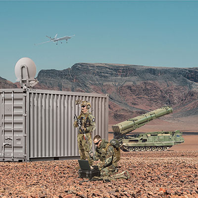
Focus Telecom has introduced a new timing product for defense and mission-critical applications, the Time-Loader.
The Time-Loader can be deployed in environments where GNSS signals are denied or disrupted, to support any ground, naval and airborne system that needs real time of day (TOD) and 1PPS external synchronization aligned to UTC or GNSS.
In this emerging era of rapid tactical deployment of defense systems, communications intelligence, missile defense systems, radar/electro-optical sensors and UAS batteries in the field are often in GNSS-denied or jammed environments. This situation creates challenges for access to real time and accurate time of day.
To solve this problem, the Time-Loader generates a GPS L1 C/A code RF output as if the signal were coming from a live-sky GPS antenna. It provides full-constellation GPS output and is compatible with external GNSS receivers. It encodes times with nanosecond accuracy for GPS timing receivers.
The Time-Loader’s GPS-disciplined oscillator (GPSDO) is the Microsemi MAC-SA53/55, which provides excellent UTC accuracy with outstanding hold-over rubidium clock performance.
The Time-Loader is the size of a suitcase, hand-carried and easily deployed. It activates quickly from a cold start or when sensors are deployed for the first time.
Included in the Time-Loader is a self-contained, miniature GPS simulator that provides real-time extremely accurate signals. The 18-channel full-constellation simulator stores location/time/date data in internal memory and stores complex vector data to simulate dynamic scenarios. The simulator also can be used to transcode NMEA or SCPI position/velocity/time (PVT) data into GPS RF signals.
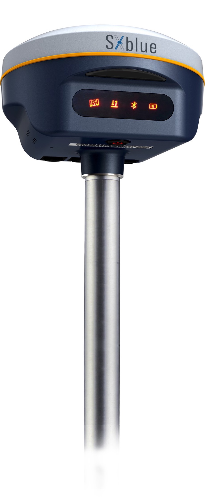
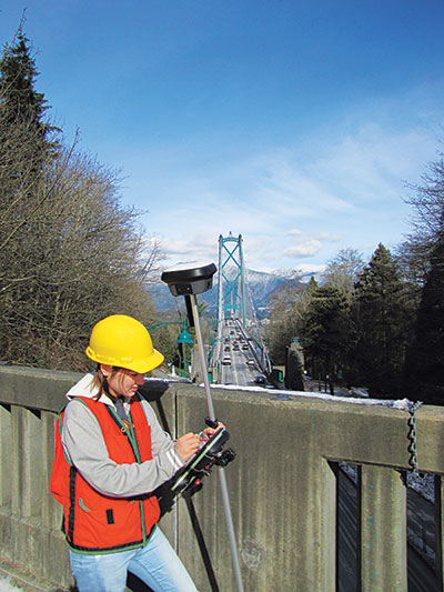
Geneq Inc. has released the SXblue SMART to meet the requirements of professionals looking for an accurate, flexible smart antenna for field work.
The SXblue SMART features a GNSS engine capable of quickly tracking all-in-view GNSS signals. Its design includes interference mitigation technology and optimization for handling a wide frequency band.
Weighing 850 g including battery, the SXblue SMART is compact, supplying the accuracy, ruggedness and maneuverability needed by surveying professionals. Its radio link is based on the Farlink protocol that allows a range of up to 8 km, a performance achievable while reserving a wide bandwidth for transmission of real-time kinematic (RTK) data.
In addition to a tilt sensor for measurements in hard-to-reach places, the SXblue SMART features a high-performance attitude measurement module that can detect and measure movement of the device. An integrated inertial measurement unit provides even more accurate and stable measurements and increased productivity. The SXblue SMART also has a built-in thermometer for monitoring and controlling its internal temperature.
Compared to the company’s previous products, the SXblue SMART has improved communication features, including near-field communication that facilitates close communication with a controller or mobile phone equipped with this technology.
A demonstration airspace management system is playing a role during the military exercise Rim of the Pacific (RIMPAC) 2022, taking place in Hawaii and Southern California.
FlightHorizon COMMANDER, provided by Vigilant Aerospace to the U.S. Air Force, is an airspace management and detect-and-avoid system based on two licensed NASA patents. The system can be used on the ground or onboard aircraft and is designed to help keep unmanned aircraft systems (UAS or drones) safe and collision free.
For the first time, U.S. Air Force MQ-9 UAS — also known as a Reaper — is taking part in a RIMPAC exercise. RIMPAC is the world’s largest international maritime exercise, involving more than 40 ships, 30 UAS and 150 aircraft from 27 partner nations.
RIMPAC 2022 is the 28th exercise in the series that began in 1971. The 2022 exercise takes place from late June to early August.
The FlightHorizon COMMANDER demonstration system (non-U.S. Air Force) tracks air traffic in Hawaii in 2022. (Photo: Vigilant Aerospace)
FlightHorizon COMMANDER includes a 3D moving map display for air traffic situational awareness, air navigation charts, weather data, special features for the tracking and safety of uncrewed aircraft systems (UAS) and automatic detect-and-avoid functions.
The airspace management system correlates and displays air traffic and other data from a wide variety of sources including ground-based and airborne sensors, civilian air traffic data, military data and proprietary data sources. The dual-use technology provides automatic traffic warnings and deconfliction as a built-in function.
The product is based on two licensed NASA patents and has been used in ongoing NASA supersonic projects, in FAA detect-and-avoid projects, and in civilian UAS projects around flight corridors and drone ports.
“RIMPAC 2022 marks the first appearance of the MQ-9A Reaper, a remotely piloted aircraft, and its presence brought in military teams from California, New Mexico and Nevada,” the Air Force stated. “With personnel from both the active-duty element, Reserves and Air National Guard, the collective group ensures that it is fully operational. All the while, everyone learns new techniques that it will take to improve their day-to-day operations upon returning home.”
“Vigilant Aerospace is thrilled to support this large-scale exercise,” said Kraettli L. Epperson, CEO of Vigilant Aerospace. “Support of this exercise is an especially useful demonstration of the multi-sensor and multi-data source capabilities of FlightHorizon and the ability to track hundreds of targets simultaneously.”
Vigilant Aerospace holds a U.S. Department of Defense IDIQ to support military adoption of the system for UAS and airspace safety.
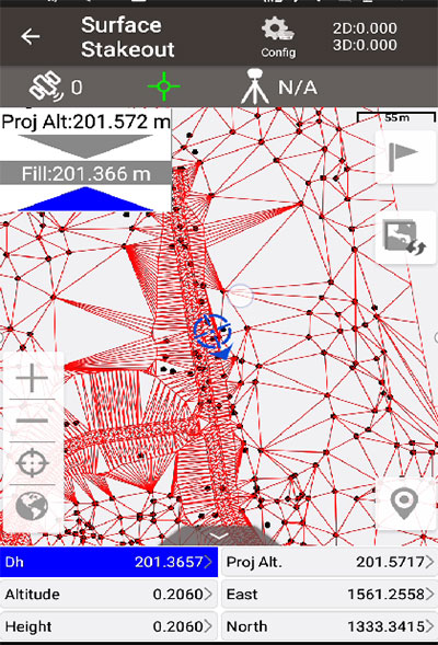
Tersus GNSS has updated its surveying smartphone app, Nuwa. The latest version includes features such as vector map import and digital surface stakeout.
The Nuwa app runs on Android and is reliable, and easy to operate. It has rich and powerful functions that can help surveyors complete measurements more efficiently and accurately.
The app is designed to work with the David and Oscar GNSS receivers from Tersus GNSS, plus other receivers that support NMEA-0183.
New features in Nuwa version 2.3.3.2 include:
Vector map import and stake. The new version supports importing vector maps in DXF, LandXML, KML, and KMZ formats in the import module, optimizes the loading speed of vector maps for display in the Survey and Stakeout interface, and allows direct clicking to select points and lines on vector drawings for staking.
Digital surface stakeout. The new version supports importing DXF files containing 3dface entities and LandXML files containing surfaces, manually selecting points to form Delaunay TIN, and entering surface offsets for fill and cut value interpolation calculations in Surface Stakeout.
Update version description. Now, when receiving a version update, the highlights of the latest version are displayed directly in the application, including essential or market-focused features and fixes for issues.
Existing features of Nuwa include:
Ability to configure base, rover and static surveys
Graphical interface with background map (online/import)
My previous column highlighted that orthometric heights in NAPGD2022 will be defined through ellipsoid heights and a geoid model, such as GEOID2022. Therefore, changes in the geoid model will be very important to users estimating orthometric heights using GNSS. I briefly described the geophysical reasons for changes in the geoid that affect the orthometric height of a mark.
For the past four years, I have discussed in my columns the tasks associated with the new, modernized 2022 reference frames. It’s now the middle of 2022, so where are the new reference frames? Well, on June 9, Dru Smith, NSRS modernization manager for the National Geodetic Survey (NGS), provided an update on the status of the modernization in a webinar. The Powerpoint slides and video of the presentation can be downloaded from the NGS website under the following title: It’s 2022…Are You Done Yet? I will highlight some of the items from the webinar, but I encourage everyone to download the video and listen to the webinar.
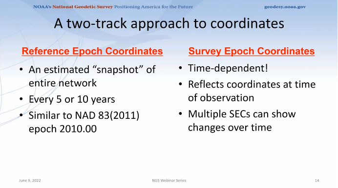
First, Smith mentioned that NGS will be providing new types of coordinates. The NGS denotes this as a two-track approach to coordinates: Reference Epoch Coordinates (REC) and Survey Epoch Coordinates (SEC). See the box below.
New types of coordinates (Image: NGS June 6 webinar)
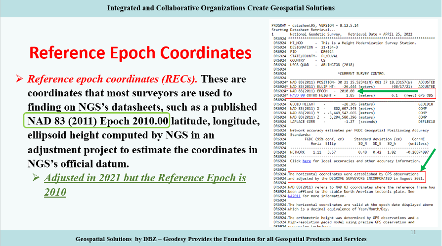
Reference Epochs Coordinates (REC) are defined in NGS Blueprint for the Modernized NSRS, Part 3 as coordinates computed by NGS in an adjustment project to estimate the coordinates at one of the official reference epochs that NGS will define in 2025. RECs are similar to coordinates computed by NGS in a nationwide adjustment project such as the National Adjustment of 2011 (see the box below).
NAD 83 (2011) epoch 2010.00 coordinates (Image: NGS)
NGS has not determined what data will be included in the first iteration of RECs. For the 2020.00 project, the current cutoff date for incorporating data is Dec. 31. Users can submit the data to NGS via OPUS projects and the OPUS-Share tool. To increase the submission of GNSS observations on marks, NGS has developed a beta OPUS-Projects 5.0 webtool that will allow real-time kinematic and real time network (RTK/RTN) observations to be submitted.
As previously mentioned, at this time, the NGS has not determined the cutoff for the earliest data to be included in the determination of the 2020.00 RECs. The agency will be conducting experiments to determine the appropriate cutoff date. These coordinates will require an intra-frame velocity model (IFVM) to generate the RECs at the specific reference epoch.
As of February 2021, based on NGS’ Blueprint for the Modernized NSRS, Part 3, version February 2021, the following is the agency’s policy with regard to RECs:
For a given mark and a given reference epoch, the REC will never be changed–except to correct a blunder.
This does not prevent NGS from adding new RECs
on points with new data that have not yet had an REC computed
for marks that do not have an REC in the most recently passed reference epoch, a new REC can be computed and added to the NSRS.
Survey epoch coordinates (SECs) are defined as coordinates computed by NGS at a specific survey epoch. Users will submit their data and its metadata to NGS, and NGS will then check, adjust and define the coordinates at one “survey epoch.” These coordinates will be “part of the NSRS,” Smith said. NGS is computing coordinates in this manner to provide the best estimate of the coordinates at any mark at a specific moment in time, which is very important in areas influenced by crustal movement.
So, how will NGS process and generate these SECs?
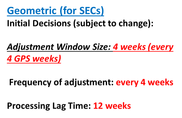
Survey epoch coordinates (SECs) are designed to provide time-dependent geodetic coordinates. Therefore, NGS has to choose some time span in which all observations will be processed together to yield a single SEC of a mark. NGS denotes this time span as a “geometric adjustment window.” NGS wants the adjustment window to be short enough so that movement of a mark did not occur between repeat observations (or was small enough to be ignored) and long enough for users to efficiently and effectively collect redundant observations for submission to NGS (see the box below).
One or more GNSS occupation(s) over a single mark will be processed into one survey epoch coordinate when all occupations take place within one geometric adjustment window.
If a user submits two occupations on one mark, but they happen to fall in two consecutive geometric adjustment windows, NGS will use them to create two distinct survey epoch coordinates. Each SEC will be based on one occupation.
Future columns will provide more explanation about this concept of a geometric adjustment window and how NGS will process the data to generate survey epoch coordinates.
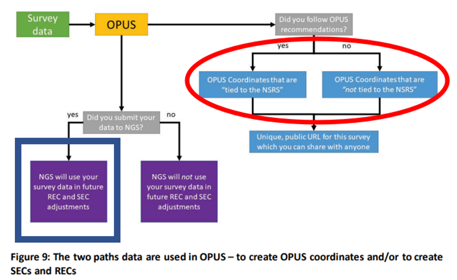
NGS is developing models and tools for users to submit data to NGS to compute coordinates — including OPUS coordinates, reference epoch coordinates and survey epoch coordinates. Figure 9 from Blueprint for the Modernized NSRS, Part 3, version February 2021, is a schematic that shows the flexibility NGS is building into an OPUS-type webtool. Basically, if users follow NGS guidelines and rules, and submit their data to NGS, then NGS will compute and publish REC and SEC coordinates (see the blue outline in the box below). If users only want to compute OPUS coordinates, then they can use NGS’s webtool without submitting the data to NGS (see the red outline in the box below).
Building flexibility into OPUS (Image: NGS)
Dru Smith’s June 9 update on the status of the modernization provided a mockup of how users will be able to retrieve data using their web browsers — a prototype is being developed. The data will also be available in downloadable form such as an XML file for users to input the data and metadata into their programs or databases. I recently discussed some of this material at seminars I presented at the Florida Surveyors and Mapping Society’s 67th annual conference held in Palm Beach Gardens. The participants were very interested in the prototype, but really wanted to learn more about the format and process of the downloadable XML files. I’m sure future NGS webinars will address this topic. I emphasized to the group that they should watch the entire presentation and provide feedback to NGS. As mentioned above, Powerpoint slides and video can be downloaded from the NGS webinar website.
The boxes below highlight a few of the options NGS is considering. The box “Data Delivery – Prototype” is an example provided by Smith during his webinar. It should be noted that the images of the prototype are not included in the downable slides, but they are part of the video. The images presented in this column are screen captures from the video.
Data delivery prototype. (Image: NGS)
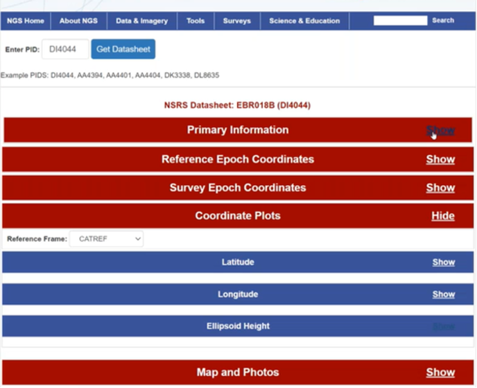
The box below provides some of the basic information of a mark, such as its PID, name, stability, GNSS usable code, setting and the latest recovery information. Again, this is a prototype, so users should feel free to send feedback to NGS. NGS wants to generate a usable product, and is interested in user feedback.
Primary information prototype. (Image: NGS)
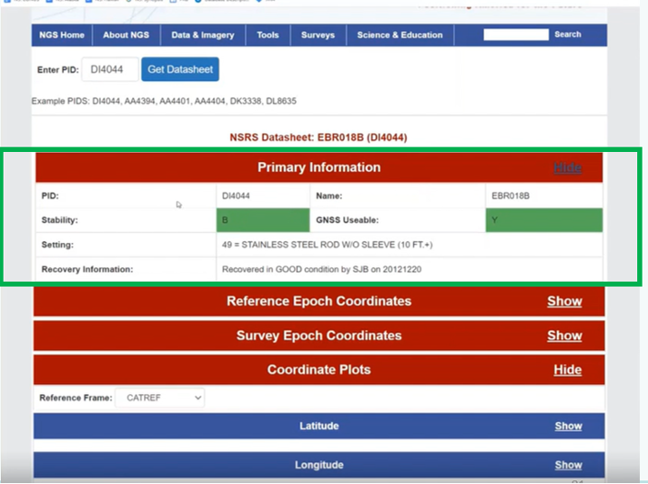
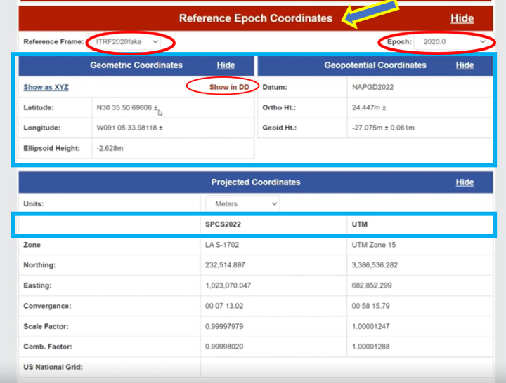
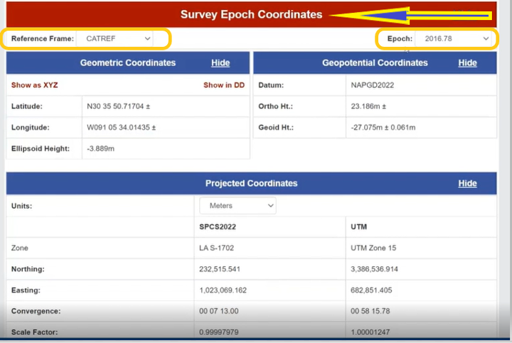
As previously stated, NGS is implementing a two-track approach to coordinates: publishing REC and SEC. The box below provides the REC information of a mark when a user clicks the “Show” button. As shown in the diagram, the reference frame and epoch are provided, as well as the geometric coordinates (latitude, longitude, ellipsoid height) and geopotential coordinate information (NAPGD2022 orthometric height and geoid height).
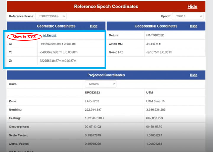
NGS provides an option for individuals who want the geometric coordinates in the X, Y, Z format (see the box below). Remember, this is only a mockup of a prototype, to give us an idea of the direction NGS is going with its data delivery system in the new, modernized 2022 NSRS.
REC Shown in X,Y,Z. (Image: NGS)
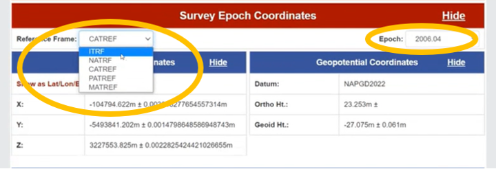
Similar to the REC, the prototype includes SEC. For a mark, the latter are different from the former because SEC are computed at the epoch of the survey observations (see the box below).
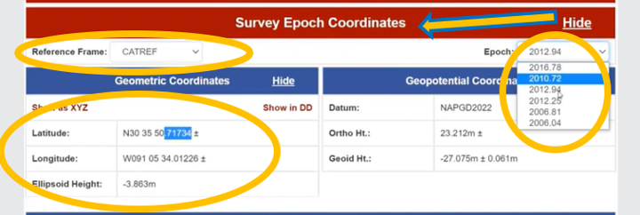
The box titled “SEC in CATRF – Prototype” is an example of a mark in the CATRF reference frame and the survey epoch of 2012.94. As indicated in the diagrams, users will be able to select the reference frame (ITRF, NATRF, CATRF, PATRF and MATRF) and the survey epoch.
SEC in CATRF – Prototype
Option to Select Survey EpochOptions to select reference frame (Images: NGS)
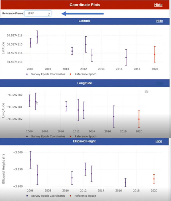
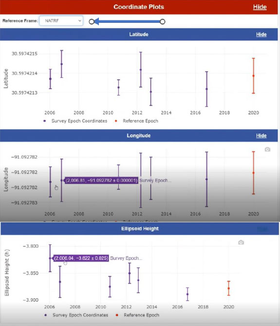
Another feature of the data delivery system is that it provides plots of a mark’s survey epoch coordinate values at different epochs. In the example shown in the box below, the plots provide values of a mark’s latitude, longitude and ellipsoid heights based on each survey epoch data. The user can select various reference frames of the mark to understand the change based on the reference frame.
Coordinate plots in ITRF prototype. (Image: NGS)
The box below clearly shows a slope in the changes in coordinates based on survey epochs, especially in the longitude. This is the plate rotating in time. You can see the changes in latitude, longitude and ellipsoid height in the NATRF reference frame for the same mark. The latitude and longitude plots do not show a slope because the plate rotation is removed using a model to change from the ITRF reference frame to the NATRF reference frame. That said, the ellipsoid height plots look the same because the rotation model does not change the ellipsoid height.
Coordinate plots in NATRF prototype. (Image: NGS)
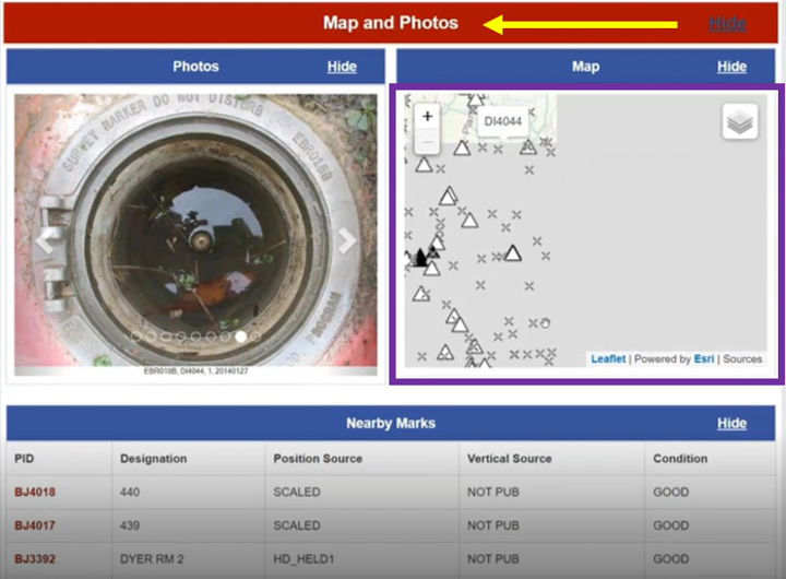
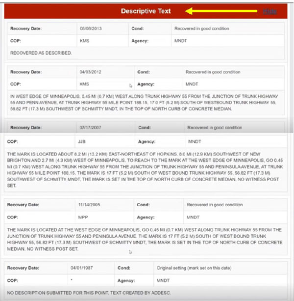
The prototype also provides maps, photos and descriptive text of the mark.
Map and photos of a mark in the prototype. (Image: NGS)Descriptive text prototype (Image: NGS)
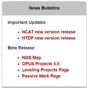
Some of this data delivery output may seem familiar to users who have used the NGS beta routines (see the box below).
Beta Routines
Beta routines (Image: NGS)
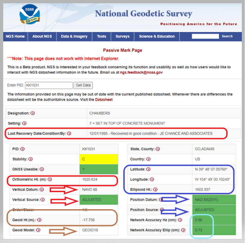
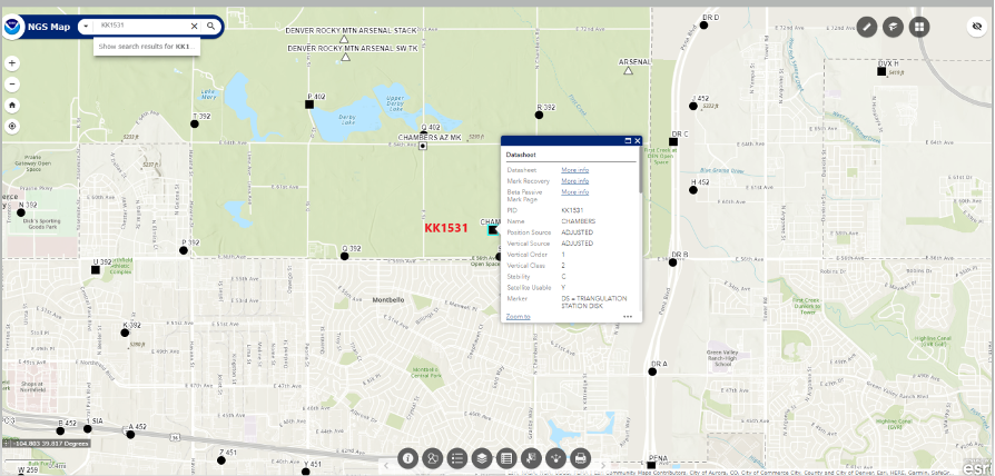
For example, the Passive Mark Page Webtool provides the coordinate information for a mark. My October 2020 column described the tool is detail. See below for an example of the passive mark tool.
Beta Passive Mark of KK1531 (Image: NGS)
The NGS Beta Map routine enables users to link to NGS datasheets, the passive mark tool and mark recovery, as well as connect to OPUS Shared Solutions and the NOAA CORS Network. See below for an example. It also provides a measuring tool, multiple basemaps and the ability to export data. My December 2021 column described the NGS Beta Map in detail.
Example of NGS Beta Map Routine for KK1531 (Image: National Geodetic Survey)
Only three years remain before the release of the new, modernized NSRS. I encourage everyone to try all of the beta products, and download Dru Smith’s June 6 webinar for a better understanding of the agency’s current thoughts on how it will provide data to users in the new, modernized NSRS. As for all the NGS beta products, the agency would like users to try the tools and provide feedback on what they liked and what they didn’t like, as well as any additional information you need or would like to see. The NGS is trying to develop tools useful to everyone, but that won’t be possible unless they hear from users.
The following statement on NGS beta products explains how to provide feedback and why it is important:
“This is a beta product. NGS is interested in your feedback concerning its function and usability as well as how users would like to interact with NGS datasheet information in the future. Email us at [email protected].”
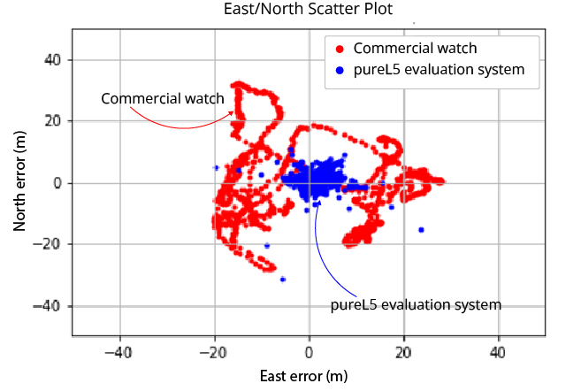
OneNav’s pureL5 more accurate in urban testing without sensor augmentation
Image: OneNav
OneNav is sharing side-by-side test results comparing its pureL5 GNSS receiver customer evaluation system to a leading Android smartwatch.
OneNav is a Silicon Valley, California-based technology company designed to power high-performance positioning for location-dependent mobile services.
In a challenging urban environment, oneNav averaged six times better accuracy than the smartwatch. Both units used commercial-wearable antennas for testing. While the oneNav system used only GNSS measurements, the smartwatch GNSS results were augmented by inertial sensors.
At the 95th percentile, the pureL5 unit reported 8-meter accuracy compared to nearly 29-meter accuracy for the smartwatch; pureL5 accuracy includes artificial intelligence/machine learning algorithms that improve the system over time.
“The L5 signal is more accurate and reliable than L1, it has higher power and wider bandwidth, and it is less jammable,” said Steve Poizner, co-founder and CEO of oneNav. “We looked at where the market is heading, with the wearables and tracking device markets exploding and the demand for higher accuracy increasing, and we asked, ‘Why keep two bands/two RF chains/two antennas when you can get superior performance with just L5?’”
The oneNav team comprises top GNSS experts from Qualcomm, Apple, Intel, SnapTrack, SiRF, Trimble and eRide who have decades of GNSS and mobile industry experience. The team has expertise in GNSS system architecture, multipath mitigation, signal processing, ASIC design and AI/machine learning, and collectively has filed more than 300 career GNSS patents.
Investors include Google Ventures, Norwest Venture Partners and GSR Ventures.
“Seen & Heard” is a monthly feature of GPS World magazine, traveling the world to capture interesting and unusual news stories involving the GNSS/PNT industry.
Ukrainian TV host Serhiy Prytula crowdfunded $20 million to buy Bayraktar drones for the nation’s defense against Russia. Baykar, a Turkish defense manufacturer, turned down the money and opted instead to donate three military drones to the country. The Turkish-made Bayraktar TB2 drone has been a key instrument used by the Ukrainian military to repel Russian forces, with the ongoing war the first major conflict in which the Bayraktar drones have been deployed.
Photo: Nicola Lercari, assistant professor of World Heritage, UC Merced
Arrested Decay
Scientists from the University of California (UC) Merced have mapped the fragile remains of Bodie, a Gold Rush ghost town. With harsh weather conditions, wildfires and earthquakes, only 10% of the original town is still intact. Researchers used a GeoSLAM handheld scanner to document more than 100 structures over four days. The scans preserve Bodie’s archaeological signature and enabled a 3D reconstruction of Bodie at its height in the 1870s.
Sea-level changes are critical to the island nation of Singapore. To help map ground deformation, researchers from the Earth Observatory of Singapore will access GNSS data collected by the Singapore Satellite Positioning Reference Network (SiReNT), along with a decade of archived GNSS data. SiReNT, an initiative of the Singapore Land Authority, produces precise positioning data with up to 3-cm accuracy. With four new coastal GNSS reference stations installed, EOS is beginning to study more accurate ways to measure deformation and climate effects.
A new indoor positioning system is helping hospitals and other healthcare facilities. PenguinIN connects to a facility’s Wi-Fi infrastructure to help staff track and locate key items, a task any nurses say takes an hour of every shift. In emergency rooms, it can track how long patients have waited and how long a physician has spent with each patient. Facilities also can use it to track air quality including dust, temperature and possible water leaks. PenguinIN applies advanced machine learning to establish the location of indoor objects, people and smartphones with up to 1-meter accuracy.
Galileo Second Generation Batch#1B satellites. (Image: ESA).
Technology multinational GMV has been awarded the NAVGUARD project by the European Commission.
NAVGUARD (Advanced Galileo PRS Resilience for EU Defence) will develop ground and space systems to detect illegal activities on GNSS frequencies and geolocate their sources. It also will build an information-management subsystem together with a user interface to provide a situational awareness picture.
The Galileo Public Regulated Service (PRS) is an encrypted navigation service for governmental authorized users and sensitive applications that require high continuity.
According to the EU Agency for the Space Programme (EUSPA), the PRS signal will ensure better continuity of service to authorized users when access to other navigation services may be degraded (resilience). In cases of malicious interference, PRS increases the likelihood of the continuous availability of the signal-in-space (robustness).
NAVGUARD is among various European Defence Fund (EDF) projects designed to sharpen the competitiveness of the European Union defense industry and strengthen the EU’s strategic autonomy. Besides navigation, the projects contracted to GMV will focus on developing missile defense system capabilities, systems for dismounted soldiers, avionics, command and control and cyber defense.
Easily installed GNSS guidance kits offer access to design and payload data
Heavy equipment maker Komatsu is offering Smart Construction Retrofit kits to enable affordable fleet upgrades. With the kits installed, conventional Komatsu excavators become “smart” with 3D guidance and payload monitoring.
Once a conventional excavator is retrofitted, operators no longer have to set up a laser or bench every time the machine moves. The kit’s GNSS receiver determines where a machine is on the job site and what the target grade is. The need for additional labor is reduced because the technology collects and delivers information directly to the operator, so fewer people have to be working on the ground or in an open trench.
Designed to improve grading performance and provide more time- and cost-management tools, Smart Construction Retrofit can bring 3D to most Komatsu excavators in a fleet. The entry-level solution can help bridge the technology gap. It gives operators the latest design data, measures payload volumes and load counts, and allows managers to monitor production from the office by integrating Smart Construction applications.
The payload meter helps prevent overloaded trucks by promoting proper loading weights for on- and off-road vehicles, to reduce the potential for equipment damage and other risks.
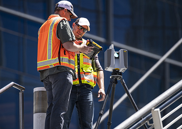
Trimble has introduced the Trimble X12 scanning system to the geospatial scanning portfolio. The X12 integrates intuitive Trimble software for precise data capture and in-field registration with 3D laser scanning and imaging hardware technology from Zoller+Fröhlich (Z+F), combining the expertise of two industry leaders into a single solution.
The Trimble X12 can be operated by using Trimble Perspective field software installed on a Trimble T10x tablet to enable registration and refinement of scans in the field, ensuring project accuracy and completion before leaving the jobsite. Users can also leverage Trimble’s customized onboard software menu to configure and operate the scanner.
Data is exported from the field and processed in the office with Trimble RealWorks software or third-party software. Final deliverables can be shared online with clients and stakeholders using Trimble Clarity, a browser-based data collaboration and visualization tool.
Transforming high-quality 3D data into decisions — such as using scans, models and imagery to determine the structural integrity of aging infrastructure — is streamlined with the Trimble X12 because the data can reside within the Trimble software ecosystem. This allows users to easily visualize, manage and evaluate the project throughout the entire workflow, even for beginners and new users to scanning technology.
With features including range (from 0.3 up to 365 meters) and scan speed of up to 2.187 million points per second, the Trimble X12 produces scan data and images with high quality and clarity, complementing the Trimble X7’s capabilities within the scanning product portfolio.
“The Trimble X12 puts the most advanced 3D scan and image capture within reach for a variety of skill levels,” said Jacek Pietruczanis, business area director for Scanning and Mobile Mapping, Trimble Geospatial. “The system enables advanced scanning professionals to improve their productivity with top-of-the-line performance and efficiency gains, while those new to scanning can easily unlock this advanced capability with the touch of a button.”
Jason Poitras (left) and Marc Veinotte of MicroSurvey test a multi-constellation OEM rover with the FieldGenius for Android field controller software. (Photo: Gavin Schrock)
It’s about more than advances in technology — peak times demand peak productivity
Trusty legacy rovers have served surveyors well. Under the right conditions and with proper procedures, a 20-year-old rover might still deliver precisions that could match the latest and greatest.
We’ve become so used to the limitations of legacy gear that we’ve built our workflows, expectations, and job estimates around them. However, in the past few years, the state of GNSS rovers has experienced a sea change, with gains in productivity, the ability to work in mixed environments, ease of use, and increased speed, repeatability and reliability — these developments have come at an opportune time.
Peak Times
Surveying always has been a feast-or-famine prospect; the rises and dips in economics are felt sharply within the profession.
In many places, there is more work than surveyors can accommodate, with competition to recruit and retain enough field personnel to meet demand. It is unclear how long this peak will last. Surveying firms recognize this and do their best to take on as many projects as they can.
Staffing is an acute challenge. Firms have had to dip into incentives beyond the usual pay and benefits packages to attract and retain qualified field personnel. Having the latest gear is a definite plus. Experienced surveyors know much they struggled with legacy gear: GPS-only or GPS + GLONASS only, slow processors, poor multipath performance, and field-data-collector operating systems and software that are obsolete or no longer supported.
Despite the immediate need, it’s generally less desirable to hire people with no surveying experience and train them from scratch. However, newer rovers and field software often do not have the same steep learning curve posed by legacy systems and methods.
Productivity Now
It is hard to say how much of the productivity gains, stated by various manufacturers for their newest systems, will be realized for your specific workflows, but simple testing can give you an idea.
When surveyors try out new rovers, they tend to find themselves so impressed by the first unit tried, they conclude it must be “the best” and eschew due diligence in the selection process. That aside, I believe it is safe to say that there is a near across-the-board productivity improvement with the latest generation of rovers.
Most rovers now provide no-calibration tilt compensation. (Photo: Gavin Schrock)
A Confluence of Factors
We haven’t seen such a sea change in GNSS rover technology in decades; most gains have been incremental. Similar jumps in the past included going from the static-only world to real-time and the first additional constellation beyond GPS.
While the early days of GLONASS were rocky, and most manufacturers were hesitant to productize an unreliable and noisy solution, it did eventually improve. The effect of nearly doubling satellites in view translated to productivity gains. But that was two decades ago.
The recent advent of true, multi-constellation GNSS has had a profound impact on the state of rovers. In 2020, both the Galileo and BeiDou constellations reached a full level of global coverage and signal integration.
Many rovers were already equipped to utilize some (but not all) of the newest satellites and signals. Interface control documents (ICD) for some of the signals have only been released by the constellation providers in the past few years. ICDs provide signal specifics that manufacturers need to integrate them into GNSS solutions.
Some rovers (and base receivers) developed four or more years ago may not be able to take advantage of the full complement of signals. And many did not have the processing power to utilize so many signals from so many satellites in real-time solutions.
By contrast, nearly every new GNSS board released in the past few years has greatly increased processing power, often double that of legacy gear.
Newer rovers are able to work better in sky-view-challenged and multipath hazard-prone places than rovers from only a few short years ago. And it is not just about the total number of channels on a rover datasheet, it is about how many are actually being utilized, how much of that data the processors and real-time kinematic (RTK) engine can handle, and how modernized signals are being leveraged.
Modernized signals are yielding additional advantages. The expected benefits of L5 for the GPS constellation have been widely promoted. L5 was designed to be robust enough for certain safety-of-life applications. The L5 signal is being deployed incrementally to the GPS constellation and should be broadcast from 24 satellites by 2027.
Modern receivers incorporate multi-GNSS signals that can improve performance under tree canopy. (Photo: Gavin Schrock)
I have heard surveyors say they won’t bother upgrading until L5 is complete. But wait — two other constellations already have third-signal capabilities. Indeed, there are 3, 4, 5, even 6 usable signals (in the case of Galileo) already available — modernized, robust signals.
Although L5 will only make this better, you can reap the benefits of signal modernization right now. Some of the innovation put into these modernized signals contributes to reducing certain sources of error. For instance, the Galileo E5a-E5b AltBOC — multiplexing signals in a wide band — is particularly beneficial for dealing with multipath.
Rovers have evolved in other ways besides multi-constellation integration. The decades between these sea changes brought developments such as electronic bubbles, better operating systems, and automation of some functions, but essentially the form factor and functionality of a surveying rover has not changed much. There have been some gadgets and gimmicks along the way, but otherwise rovers had remained pretty much standard in those intervening years.
Real-time precise-point positioning (PPP) has matured to the point that it could be viewed as survey-grade (at least in the horizontal). The delivery of clock, orbit and other data broadcast from geostationary communications satellites (as a service) for PPP means that, for many applications, high-precision positions can be processed by a rover over much of the globe — no base, no radio, no network and no cell phone connection required.
Once research and development removed the lengthy convergence times that plagued legacy PPP, it became commercially viable for many applications. Commercial providers such as Trimble (RTX), Hexagon | Leica (SmartLink), Hemisphere GNSS (Atlas) and others provide subscription services for surveying, construction, agriculture and the growing autonomy market. Most new survey rovers have a PPP option.
Multi-sensor integration, particularly of inertial measurement units (IMU), is becoming standard on new rovers. While there was some value from magnetometer-oriented tilt compensation in the past (though it could be cumbersome and somewhat unreliable), it served as a precursor to modern-day integrated GNSS/IMU no-calibration tilt.
The first no-calibration tilt system hit the market as recently as 2017; now it is hard to find a rover without it. Accessing hard-to-reach points and improved stakeout workflows are some of the benefits of tilt compensation. The development of reliable IMU/GNSS processing was also the key to fully integrating camera-based offset point capture — and soon other sensors such as lidar might be incorporated.
Market Choices
Another set of changes in the high-precision GNSS industry coincided with the above developments, growing a more competitive marketplace. This equates to more choice. The secret sauce of high-precision GNSS is no longer in the hands of the few. The glass floor has been broken, with more rovers than ever available.
Many tiers for choice have emerged.
The Top End. The manufacturers traditionally considered to be the top end continue to innovate and are usually the first to productize developments such as multi-sensor integration and PPP. They continue to lead in integrated surveying solutions, track record, performance, quality, service, support and peer user networks — which continues to appeal to many users. However, they also have second-tier offerings to suit various markets, regions and value propositions.
Whether to Use OEM Devices. For many users, there are compelling reasons to stick with top-end solutions, but there always has been room for other price point options. Until recently, most lesser-known rover brands exclusively integrated GNSS boards from a handful of well-known original equipment manufacturers (OEMs) such as Trimble and NovAtel. Sometimes new developments hit the OEM market quite rapidly — for instance, IMU integration. These third-party manufacturers may add their own touches, but in effect, nearly every rover out there offered a narrow set of DNA — until recently.
Rolling Their Own. Globally, technical universities are graduating GNSS engineers at an unprecedented rate; the prospect of mass applications such as vehicular autonomy and robotics are driving demand. With this expanding pool of engineers, it is now much more practical to develop GNSS solutions from scratch and to fully leverage multiple constellations.
Some third-party manufacturers began working with OEMs but have started developing their own boards and related technologies. I’ve tried several, and performance is, in most cases, as good as that of new boards from traditional sources..
The Rise of Mid-Price Rovers. There are a growing number of breakout rovers from lesser-known brands or rebranded models. These are about half the price of some of the top-end models, yet performance is in most cases nearly par. Some include OEM boards, or the new wave of independent boards.
I’ve seen a sharp rise in the popularity of mid-level rovers among small and mid-sized firms. However, there has not been a corresponding drop in sales of top-end rovers. It seems that surveyors are simply buying more rovers during this peak time.
Receivers-as-a-Service. Another approach for surveying and asset-mapping rovers is pay-as-you-go. This means you do not have to make large up-front investments in hardware. Instead, you pay for high-precision capabilities through subscriptions or tokens when you need it. This can be a good choice for occasional or seasonal users.
One example is Trimble’s Catalyst system. For Catalyst, the hardware investment is an inexpensive antenna, and then you access a subscription service via your mobile field data collector, tablet or smartphone to activate the software-defined receiver (SDR).
Another such model is Flex. With Flex, you have the option to pay full price for the full receiver/antenna to operate as a conventional rover. Alternatively, you can choose to pay a lower up-front price for the rover and use tokens to activate the high-precision capabilities.
Surveyors should put new rovers through their paces before choosing. (Photo: Gavin Schrock)
Low-Priced Rovers. Two external factors have fostered a mini boom in low-cost rovers: R&D for mass markets such as autonomy, and RTK/post-processed kinematic (PPK) solutions for drones, which are often used to reduce the need to set ground control points.
In both segments, inexpensive and often small GNSS boards have been developed. For drone applications where a base was needed for RTK/PPK methods, developers sometimes took the same GNSS board in the drone and packaged it as a base. It did not take long for some of these developers to package the rover for surveying or asset mapping (with geographic information system, or GIS).
While these rovers can perform just as well as top-end or mid-priced rovers in optimal conditions, they may struggle in mixed environments. I’ve tried some, and I can see why every surveyor I’ve asked about performance adds “for the price” to their assessment.
Other developers have taken this a step further, selling a bare-bones rover for less than $1,000, though these can take a lot of tinkering and extra attention to fit into a production workflow. There are even folks creating do-it-yourself rovers. I am not seeing many large firms, who have high-ticket projects and need to conduct integrated surveying, opting for lower priced systems.
We are riding a new wave of GNSS rovers, awash with more choices than ever. In this period of increased demand for surveying services, it might be a great time to upgrade and boost productivity.
New Players
A “roll your own” example is Tersus GNSS, which has designed and manufactured in-house GNSS boards and RTK engines since its inception in 2014. I asked Winston Wen, founder and CEO of Tersus, why they chose this strategy.
“I’m a hardware guy; electronics, computer science, signal processing, etc.,” Wen said. “In 2014, I took a look at the price and portfolios for high-precision, and for equipment for surveyors — the price point looked exceptionally high. From my point of view, it looked like there was room for a new player, and I felt we could do better. There are also growing markets for applications for high-precision GNSS, such as the internet of things (IoT) and autonomy.”
Tersus has experienced solid reception for its products globally. I asked Wen if he felt GNSS for surveying has reached a new level of performance. “Yes, nowadays with 50 satellites, that is huge. Surveyors will be very happy with performance, especially in environments with limited sky view. At this time, there don’t appear to be any new signals announced, so rovers bought today should be top performers to, say, 2025 and beyond.”
Industry Insights
GNSS executives told Gavin Schrock about recent developments in their companies.
Neil Gerein, Senior Director of Marketing,
Autonomy & Positioning Division, Hexagon
As satellite constellations were modernized, GNSS receivers kept pace to offer multi-constellation and multi-frequency capabilities to culminate in the latest technologies in PPP corrections.
For example, Hexagon’s RTK From the Sky technology is able to achieve highly available corrections with centimeter-level accuracy globally. However, modern GNSS receivers also offer other benefits, such as interference mitigation and spoofing detection for improved positioning robustness, multipath mitigation, and more powerful sensor fusion.
Miles Ware, Vice President,
Marketing & Global Customer Care, Hemisphere GNSS
Much like the constantly evolving world of smartphones, tablets, and computers, the improvements in multi-constellation GNSS receiver performance have been significant, even over just the past few years.
Many legacy rovers, bases and reference stations that are older than four years cannot track some of the newest signals, such as from BeiDou Phase 3 satellites. This means some of the highest performing signals available are now accessible to many users. As fewer BeiDou Phase 2 satellites continue to transmit, many legacy receivers will no longer have the performance they once did.
With upcoming services such as OSNMA (the Galileo GNSS data authentication service) and global PPP signals, many receivers from a few years ago do not have the CPU capacity to employ them. Today’s GNSS engines track more satellites, more signals per satellite, and have more CPU to perform advanced operations, all while consuming the same or less power than previous generations.
Francois Martin, Vice General Manager,
CHC Navigation
The latest GNSS RTK rover technology evolutions are based on the maturity and enhancement of satellite navigation systems, as well as the integration of IMU sensors into the receivers.
The most recent generation of our GNSS rovers, such as the CHCNAV i83, is based on the sophisticated iStar algorithm that significantly improves the efficiency of GNSS satellite signals tracking for unmatched performance in GPS, GLONASS, BeiDou, Galileo and QZSS constellations, utilizing all available frequencies, including BeiDou 3.
Moreover, the fusion of GNSS and IMU technologies enables centimeter-level positioning, maintains fixed and reliable RTK accuracy, and collects points faster than ever before, even in challenging conditions. GNSS survey productivity is increased by up to 30%, and the user base expands from experienced users to new users such as construction site foremen.
Gavin Schrock, PLS, is a practicing land surveyor, the operator of a cooperative real-time GNSS network in Washington state, and a technology writer.
“Seen & Heard” is a monthly feature of GPS World magazine, traveling the world to capture interesting and unusual news stories involving the GNSS/PNT industry.
Photo: spxChrome/E+/Getty Images
Citizens Clean Up Coasts
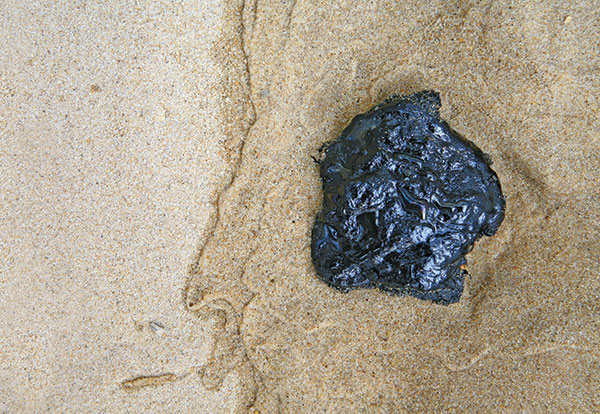
Two citizen groups are taking action with the help of Esri ArcGIS mapping tools. North Coast World Earth uses Esri Ireland’s platform on the Northern Irish coast to record litter hotspots and engage with local communities. The volunteer group has collected nearly 3 tons of litter. In California, the Surfrider Foundation employed ArcGIS Hub to streamline cleanup operations after a major oil spill off Huntington Beach in October 2021. Citizens submitted more than 1,100 reports using the ArcGIS QuickCapture photo app to share the date, time and coordinates of toxic tar balls on beaches from Oxnard to San Diego.
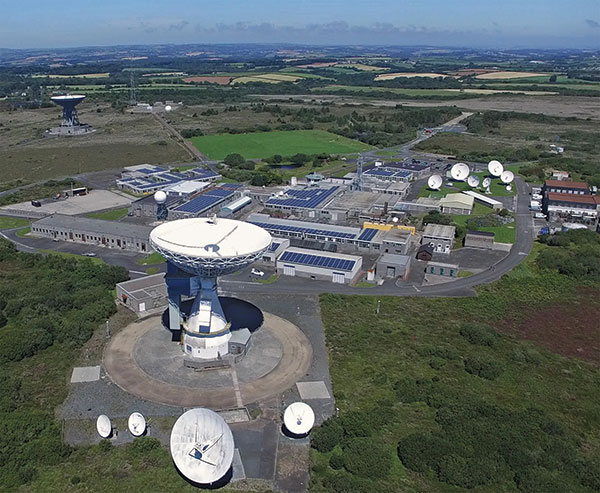
A new series of tests will assess whether the United Kingdom satellite-based augmentation system (UKSBAS) for GNSS can develop into full operational capability to support safety-critical applications post-Brexit. Inmarsat, Goonhilly Earth Station and GMV NSL are conducting the UK Space Agency-funded tests. The signal is now stable and operational, enabling ongoing testing and validation by industry, regulators and users. If successful, UKSBAS will enable assessment of more precise, resilient and high-integrity navigation for maritime and aviation users in UK waters and airspace.
Image: ESA
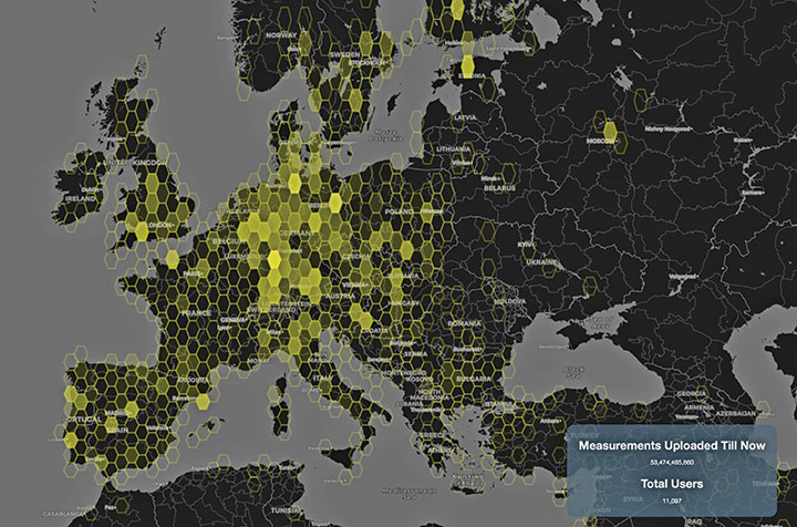
Smart GNSS Monitoring
More than 11,000 people around Europe and the world have turned their smartphones into GNSS monitoring tools by downloading the CAMALIOT app, so far delivering more than 53 billion measurements of meteorology and space weather patterns to researchers, reports the European Space Agency (ESA). ESA asks CAMALIOT volunteers to leave their smartphones by a window each night with GNSS on. The phones record small variations in satellite signals, gathering data for machine-learning analysis. More than 50 smartphone models with dual-frequency receivers can use the app.
Indian Prime Minister Narendra Modi gave his stamp of approval to his country’s indigenous NavIC during a drone festival May 27. Despite that, the Indian Army purchased three GNSS receivers from Baidu, a Chinese company, instead of relying on home-grown companies as the contract required, reports The New Indian Express. The receivers are for survey stations of the College of Military Engineering. A few Indian manufacturers objected to the purchase, the newspaper said, but their concerns were brushed aside by the Department of Military Affairs.