Category: Applications

  • Three ways R&D has shaped Galileo Second Generation

    Three ways R&D has shaped Galileo Second Generation

    News from the European Space Agency

    Dedicated research and development, funded by European Union (EU) and European Space Agency (ESA) programs over the years, has played a key role in Galileo Second Generation. 

    Among the innovations that will benefit the new satellites are the development of new atomic clocks, links that allow the satellites to “talk” to one another in orbit and a prototype ground station that can precisely pinpoint satellites in the sky. These advanced technologies will ensure Galileo continues to provide world‑class positioning, navigation and timing to users worldwide.

    The importance of R&D

    Satellite navigation is constantly evolving, with new technologies being deployed. But before a technology can fly on a satellite, it must be derisked and qualified. This is where research and development (R&D) comes in, laying the groundwork for new technologies long before they see the light of day. 

    Horizon 2020 and Horizon Europe are R&D programs funded by the EU. A significant budget from these programmes is delegated to ESA for R&D to derisk new technologies for evolutions of Europe’s Galileo and EGNOS systems.  

    Complementing these EU R&D programs, ESA programs such as the General Studies Programme (now Discovery and Preparation), General Support Technology Programme and the former European GNSS Evolution Program (EGEP) have also performed R&D for future satellite navigation technologies.  

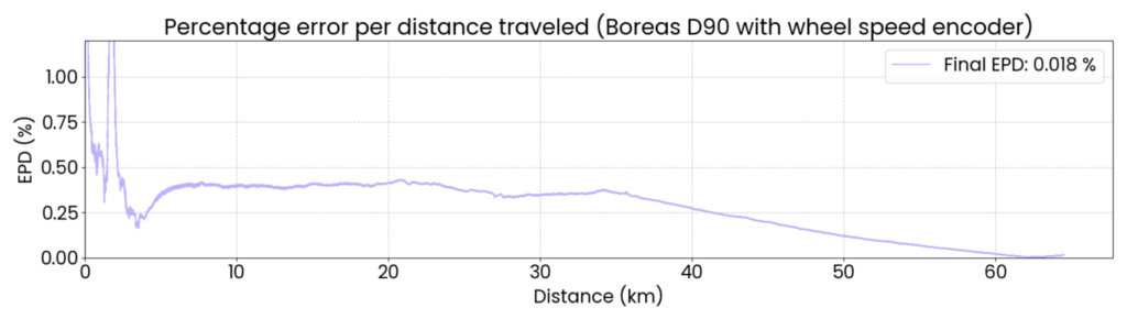
    R&D spurs the innovation that allows Galileo and EGNOS to modernise and develop new applications and services. Several activities funded through these programmes have contributed to Galileo Second Generation (G2). Some of these technologies will already fly on the G2 satellites when they are launched in the coming years. 

    New ways of keeping time

    Iodine Optical clock by SpaceTech, Germany
    Galileo relies on highly precise onboard atomic clocks to ensure accurate global positioning and timing. Here, an iodine optical clock by SpaceTech, Germany (Credit: ESA)

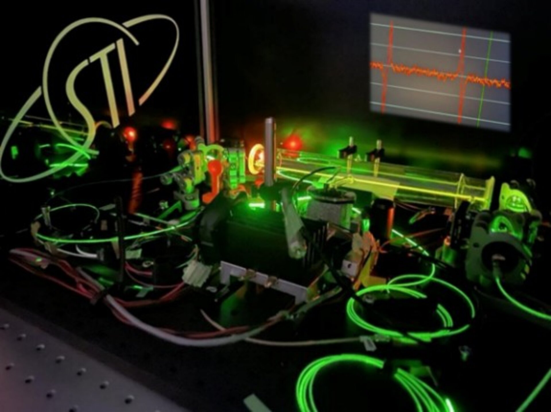
    Galileo delivers world-class positioning and timing, and its onboard clocks are the key to its performance. Each first generation Galileo satellite carries two passive hydrogen maser and two rubidium atomic frequency standard clocks. These clocks, developed by Leonardo and Safran Timing Technologies, respectively, are currently Galileo’s only space-qualified clocks.

    Rubidium Pulsed Optically Pumped (Rb POP) clock by Leonardo, Italy
    A rubidium pulsed optically pumped (Rb POP) clock by Leonardo, Italy. (Credit: ESA)

    To keep up with the latest technologies and allow for a broader diversity of European qualified clocks, R&D activities have encouraged European companies to develop new types of space-worthy atomic clocks. This investment is critical due to the time and expertise it takes to develop such complex and sensitive technologies. These activities aimed to develop alternative atomic clocks for Galileo that can improve performance and robustness and support Europe’s place as a leader in satellite navigation.

    Mercury Ion clock (MIC), Safran Timing Technologies, Switzerland
    A Mercury ion clock (MIC) from Safran Timing Technologies, Switzerland. (Credit: ESA)

    Seven innovative clock technologies were developed by European companies from France, Germany, Italy and Switzerland. After initial development activities, three of these clocks — proposed by Leondardo, SpaceTech and Safran Timing Technologies — were selected to progress to hardware development in preparation for a first flight.  

    Leonardo’s Rubidium Pulsed Optically Pumped clock is currently under development and planned to fly as an experimental clock on a Galileo Second Generation satellite. The Iodine Optical clock developed by SpaceTech is undergoing early development and shows potential for future use as an experimental clock on Galileo satellites. The Mercury Ion clock by Safran Timing Technologies recently launched its development activities.  

    Following an analysis of the clocks’ eventual in-orbit performance, a programme decision by the European Commission will be made before starting the operational phase of these new clock technologies.

    Conversations in the sky

    Intersatellite link transceiver by Thales Alenia Space
    An intersatellite link transceiver by Thales Alenia Space. (Credit: ESA)

    The Galileo system currently relies on links between satellites and ground stations to monitor and control the satellites and to determine the onboard clock skew. Clock skew occurs when a clock signal reaches different parts of a system at different times, which can cause errors in position calculations. 

    Galileo Second Generation will introduce inter-satellite links (ISL), allowing the satellites to ‘talk’ directly to one another in orbit. This will enable additional time synchronisation and ranging measurements that will improve knowledge of the satellites’ orbit and clock skew.  

    ISL will also allow faster data dissemination. If a particular satellite is not visible to a ground station, information can be sent to a different satellite and then passed on instead of waiting for the satellite to be visible. 

    Intersatellite link transceiver by Airbus Defence and Space
    An intersatellite link transceiver by Airbus Defence and Space. (Credit: ESA)

    Two early models of ISL transceivers that are essentially identical to those which will fly on the Galileo Second Generation satellites were designed and developed. The transceivers, which can both send and receive signals, were developed by Thales Alenia Space (Spain) and Airbus Defence and Space (Germany).  

    One of these transceivers is about to enter the formal testing phase, while the other has undergone successful environmental qualifications. After the transceivers have completed their qualifications and testing, they will be ready for their trip to space.

    Precisely pinpointing satellites

    Accurate positioning, navigation and timing relies on knowing precisely where satellites are in their orbits. Galileo satellites are located by tracking their L-band antenna transmissions from the ground. Each satellite also has a laser retroreflector, which allows measurement of their orbit to within a few centimeters. Known as satellite laser ranging (SLR), this method measures the time it takes for a laser pulse to make the trip from a ground station, called an SLR station, to the satellite and back, then uses these measurements to determine the satellite’s orbit.  Presently, SLR stations are owned and operated by scientific community users and serve multiple space missions.  

    One of the challenges of current SLR is the fact that the lasers are not safe for human eyes and cannot be used if an aircraft is flying nearby as the lasers could blind the pilots. This means SLR stations must coordinate with civil aviation and may not be allowed to use all parts of the sky. SLR stations also have limited availability due to local atmospheric conditions (clear skies are key), and low levels of automation (intensive need for human operators).

    Prototype satellite laser ranging station in Matera, Italy
    A prototype satellite laser ranging station in Matera, Italy. (Credit: ESA)

    To mitigate these limitations, a modernized, eye-safe SLR station prototype for Galileo satellites has been developed by DiGOS (Germany) and commissioned in Matera, Italy. Due to the station design and laser wavelength used, there will be no need to coordinate with civil aviation. The station’s new technologies also explore increased automation using a predefined schedule to reach satellites. Although human operators are still needed, their workload is reduced. 

    A field campaign of the prototype SLR station is planned for this year as part of the Galileo Second Generation System Test Bed tasks. It will evaluate the potential benefits of SLR as a complement to L-band ground ranging. If the station is added to the Galileo ground segment, it could enhance the system’s robustness by providing an independent means of determining the satellites’ locations. In this case, interface design adjustments would need to be made to allow operational use of the station.     

    Beyond providing another method for determining Galileo satellite orbits, this station could also help contribute to the Galileo Terrestrial Reference Frame and could support ESA navigation scientific missions such as Genesis.  

  • MatrixSpace updates platform to support multi-drone detection in real time for counter UAS

    MatrixSpace updates platform to support multi-drone detection in real time for counter UAS

    MatrixSpace has announced a major update to its edge-to-cloud MatrixSpace AI Software Platform.

    The platform now supports multi-sensor, multi-drone detection in real time for counter UAS applications. It delivers true threat assessment and early warning — detecting, tracking and identifying — to empower on-site and remote operators to make split-second decisions regarding airspace activity. The platform is sensor agnostic and easily integrated into existing systems through open APIs.

    The update dramatically improves assessing risk from small, low-flying drones in complex airspace, such as public events, critical infrastructure and battlespaces.

    The platform

    The MatrixSpace AI Platform consists of MatrixSpace AiEdge, the company’s intelligent sensor operating system, and MatrixSpace AiCloud, a software-as-a-service that collects data from AiEdge-enabled sensors for a unified view of airspace activity. Unlike other offerings retrofitted for AI, MatrixSpace AiEdge and AiCloud are AI-native, making information rapidly actionable and easier to comprehend.

    MatrixSpace AiEdge, embedded in every MatrixSpace system, provides actionable intelligence at the point of sensor data collection. It detects, classifies and tracks multiple object types, removing clutter to present a relevant picture of aerial activities, while fusing feeds from different sensors.

    AiEdge fuses detections from MatrixSpace radars with complementary sensors such as Remote ID and ADS-B into a single, real-time track. By correlating multi-sensor data at the edge, AiEdge creates a common data representation and cues PTZ (pan-tilt-zoom) cameras for rapid visual confirmation, passing high-confidence tracks to the cloud for enterprise-level analysis.

    Sitting above distributed AiEdge deployments, MatrixSpace AiCloud simplifies the management of geographically diverse sensor networks into a single, unified view. Instead of a bank of monitors displaying individual sensor feeds, AiCloud provides operators with clear visibility into low-airspace activity, alerts, and warnings across all protected sites — accessible on any device.

    MatrixSpace AiCloud combines fused, real-time data from radar, optical, ADS-B and Remote ID sensors to deliver consistent object tracking and actionable threat intelligence at scale. Within AiCloud, whitelisting and threat classification determine whether objects are friendly, unknown, or hostile, enabling fast, coordinated operator response. Local sensors continue operating autonomously when cloud connectivity is disrupted, with all activity synchronized for review once connectivity is restored.

  • Divirod, OKI completes advanced GNSS-R terrain monitoring project in Fukuoka Prefecture

    Divirod, OKI completes advanced GNSS-R terrain monitoring project in Fukuoka Prefecture

    Divirod and Oki Electric Industry (OKI) have completed a project to monitor landslide risk and slope stability across vulnerable areas in the Fukuoka Prefecture of Japan. The project deployed Divirod’s next-generation ground deformation and anomaly-detection technology to provide continuous, high-resolution monitoring of mountainous terrain prone to extreme rainfall and seismic activity.

    The initiative supports Japan’s broader effort to enhance early-warning capabilities and strengthen climate resilience following recent years of severe rainfall disasters and complex terrain-related hazards.

    Monitoring with GNSS-R technology

    For the project, Divirod designed a system comprised of GNSS-Reflectometry (GNSS-R) sensors and intelligent algorithms and deployed it across three areas of interest collecting continuous, all-weather measurements throughout the monitoring period. Divirod’s proprietary algorithms examined daily GNSS-R measurements to detect even subtle changes in the ground surface.

    Divirod’s system successfully classified the observed terrain changes into three key physical categories:

    • Slope failure events,
    • Creep/slow-moving landslides, and
    • Temporary terrain changes (often linked to rainfall or ground moisture variations).

    Hundreds of terrain changes were detected across the monitored regions and correlated with rainfall measurements and earthquake events. The results enabled detailed risk mapping and precise identification of active zones.

    The technology proved highly sensitive in differentiating short-lived disturbances from long-term geomorphological changes — an essential capability for early intervention and warnings.

    Documented landslide at Hakikoga

    A significant project highlight was successful detection of a real landslide event in August. While comparison images taken on Aug. 10 and 11 revealed visible changes in the slope during daylight hours, Divirod’s terrain change maps show that the slope movement itself occurred overnight, a time when on-site cameras were unable to observe the event due to darkness.

    Despite the lack of visual evidence, Divirod’s GNSS-R sensors registered a distinct spike in ground-movement, accurately detecting the terrain shift and providing clear evidence of a nocturnal landslide that could have otherwise gone unnoticed.

    Strengthening the disaster-preparedness ecosystem

    Divirod’s collaboration with OKI represents a significant advancement in real-time terrain intelligence for Japan, a region characterized by frequent typhoons, intense rainfall and high seismicity. The successful deployment in the Fukuoka Prefecture presents new opportunities for:

    • scalable early-warning systems,
    • automated landslide risk modeling,
    • and the integration of GNSS-R sensing with existing monitoring infrastructure.
  • UK’s Watchkeeper drone program nears the end:  What went wrong and what’s to come

    UK’s Watchkeeper drone program nears the end: What went wrong and what’s to come

    We usually look for what’s new, with innovative drones emerging and gaining traction in commercial and military applications, but this month, news of the termination of a leading UAV program has sparked interest.

    The British Army’s Watchkeeper drone program has long been the subject of criticism over development delays, cost overruns and poor performance. Recent reports that the Watchkeeper fleet could be retired as early as 2025 — though that timeline may now slip to 2027 — have renewed scrutiny of the troubled effort. Perhaps a review of the story behind this drone adventure may be in order.

    The UK has been involved with drone operations going back into the 1960s, giving this military force deep experience and expertise in the field. Political support has enabled significant investment over time. When the Watchkeeper program was rolling in 2004-05, the US was moving toward the MQ-9 Reaper project, and military forces around the world were building their own mil-spec UAVs, mostly for surveillance to support military ground operations.

    At that time, few commercial drones existed beyond radio-controlled model aircraft flown by hobbyists. The idea was growing in China at that time for DJI and quad-copters, so these multi-use UAVs eventually emerged, and have led to a multitude of outfits elsewhere also making commercially available drones.

    When the Watchkeeper program took shape in 2004, developing a custom platform was essentially the only way for the UK to obtain a medium-altitude ISTAR intelligence, surveillance, target acquisition and reconnaissance (ISTAR) drone tailored to its requirements. The Ministry of Defence identified Israel-based Elbit Systems, which produced the Hermes 450 military drone, as a close match. The program was built around an extensively modified version of that aircraft, with the goal of bringing production to the UK

    Hermes 450 (Photo: Nehemia Gershuni-Aylho)
    Hermes 450 (Photo: Nehemia Gershuni-Aylho)
    Watchkeeper-X export version (Photo: U-tacS)
    Watchkeeper-X export version (Photo: U-tacS)

    In 2005, the U.K. Ministry of Defence awarded a £775 million contract to U-TacS, a joint venture between Thales UK and Elbit Systems, for the design, manufacture and support of 54 Watchkeeper WK-450 drones. The modifications involved making the UAV all-weather capable, including Thales integrated radar/GPS system for automated landing and take-off (Magic-ATOLS), Thales MASTER SAR/GMTI radar, dual electro-optical/IR cameras, laser designator, and tweaks to the Line-of-Sight radio system, with a satellite link option. Nevertheless, the range of the radio limits operation to within less than 100 miles of the mobile base-station, but it did provide a high-bandwidth, secure, direct, unobstructed wireless link for control and real-time video and targeting data back from the vehicle.

    Cost overruns and delays pushed the first flight to 2008 in Israel. Production of the WK-450 was then established at Thales UK, formerly Racal Electronics. The technology transfer between the two companies, separated by more than 2,000 miles, operating across different corporate cultures and exchanging proprietary material, proved more difficult and time-consuming than anticipated.

    The program delivered its first aircraft in 2014. Four drone systems flew in Afghanistan during the British troop withdrawal, logging a total of just 140 flight hours. Performance fell short of expectations, particularly the system’s all-weather capability, which proved inadequate in Afghan conditions. The U.S. military encountered similar challenges with sand contamination of helicopters and fixed-wing aircraft during early operations in Iraq and Afghanistan.

    As time rolled by, Watchkeeper found some use in Cyprus and in the UK, mostly for training, but problems continued. Between 2014 and 2022 eight vehicles crashed, and most have presumably been written off. Others have apparently experienced unplanned ‘contact with ground’ in more recent times. Faith in the now pretty old drone system has waned with the British forces — even recent political pressure to hand over the remaining fleet to Ukraine has been rebuffed by the Army — maybe too many problems with which to coach Ukraine troops. Watchkeeper is apparently now dismantled for the UK, along with the whole £1 billion investment. But not without gaining a lot of knowledge and operational experience, however an expensive lesson none the less.

    The UK has operated MQ-9A Reapers in Afghanistan, Iraq and Syria for more than 18 years, but after the Royal Air Force’s success with this US drone, these too have been retired in favor of the new MQ-9B Protector. The Protector has been customized and brought up to civilian certification standards by the manufacturer General Atomics. There have been similar sad programs with many ground, marine, and air projects around the world, but this has been such a visible and unhappy tale, it’s sad to see it end, but it’s probably a good thing so that other newer, more promising projects can get funding and become successful.

    Almost in the same breath, another UK company has already been supplying unmanned cargo aircraft to Ukrainian forces for more than three years. Windracer ULTRA is a twin-prop aircraft that can lift 330 lb for up to 620 miles, with 10 hours of endurance at a ceiling of up to 13,000ft. A newer version can reportedly travel twice as far with more payload.

    In Ukraine, the drone has been supplying front-line troop emplacements on a regular basis. The UK has been using ULTRA for surveillance and parachute drop re-supply, middle-mile parcel and cargo delivery to remote destinations, and for aerial surveys in Antarctica and elsewhere.

    So, a commercial start-up got there on its own, no direct government funding other than contracted support, and apparently no JV with another company!  So does 100% government funded development work better than setting up on your own, borrowing a bunch of cash, and doing it yourself? Mil-spec stuff is special with a limited market, so it’s unlikely that governments will ever be able to pick up finished products that fulfil all needs, but as the U.S. is proving with its bulk buy of off-the-shelf small one-way UAVs, these can meet many requirements.

  • Wherobots, Felt partner to modernize geospatial data tools

    Wherobots, Felt partner to modernize geospatial data tools

    Wherobots and Felt have entered a strategic partnership aimed at modernizing the geospatial data stack.

    The integration combines Wherobots’ spatial intelligence lakehouse and compute engine with Felt’s collaborative mapping platform, connecting large-scale data engineering with interactive, map-based applications. The partnership allows organizations to move from processing petabyte-scale geospatial datasets in the cloud to exploring insights in a collaborative mapping environment without transferring large datasets between systems.

    Organizations are handling growing volumes of location-based data, and analyzing that data has historically required specialized GIS software or custom applications that were difficult to connect with modern data systems. The integration lets users create live, interactive visualizations for uses ranging from mapping fields and creating vegetation indexes to building AI-enabled user experiences and automated workflows that monitor climate risks.

    Agricultural company puts partnership to the test

    Leaf Agriculture, which provides a unified API for agriculture organizations and farms working with telemetry data from tractors and field sensors, is already using both platforms together.

    The company uses Wherobots to create data products from a large data lake of agricultural, parcel and tractor telemetry datasets. It recently announced a new product, LeafLake, built on that foundation. Leaf then uses Felt to build interactive maps based on the spatial data processed within Wherobots. Rather than relying on in-person screen-sharing sessions, the team now distributes maps via links viewable from any device. Here is an example of one of Leaf’s interactive maps.

    “Wherobots and Felt’s new integration allows organizations to move seamlessly from processing petabytes of raw geospatial data in the cloud to visualizing actionable insights in a browser-based, collaborative environment — all without the friction of traditional desktop-based tools,” said Rachel Zack, chief strategy officer and co-founder at Felt. “For modern enterprises who rely on geographic information, this is the complete, end-to-end spatial data infrastructure that makes working with GIS data at scale finally feel effortless.”

    “As climate impacts intensify — from fires to floods — maps are no longer optional; they’re critical tools for understanding a rapidly changing world,” said Mo Sarwat, CEO of Wherobots. “Yet building and scaling them has traditionally required heavy engineering effort, especially for teams working with satellite and drone data. Through our partnership with Felt, AWS users can now access, analyze and visualize spatial data directly from S3, eliminating infrastructure complexity and accelerating decision-making when it counts most.”

    For more details, please see the Wherobots blog post here.

  • Micro-Magic offers high-precision MEMS IMU module

    Micro-Magic offers high-precision MEMS IMU module

    Micro-Magic has released the U4930 series, a reliable and cost-effective six-axis MEMS inertial measurement module that can be widely used in navigation, control and measurement fields for vehicles, ships and drones.

    Typical applications include vehicle/ship attitude measurement, UAV attitude reference and trajectory control, mobile mapping, track inspection, underwater high-precision navigation, and Satcom-on-the-Move.

    The U4930 series integrates high-performance MEMS gyroscopes and MEMS accelerometers within an independent structure. The three-axis MEMS gyroscopes sense the angular motion of the carrier, and the three-axis MEMS accelerometers sense the linear acceleration of the carrier.

    The system internally performs compensation for zero bias, scale factor, non-orthogonal error, and acceleration-related terms across all temperature parameters, maintaining high measurement accuracy over a long period of time.

    The module supports custom communication protocols and provides synchronization for GPS/GNSS time data and pulse per second (PPS) signals.

    The U4930A series inertial measurement module can be configured with various hardware and software to meet user needs.

  • China rolls out BeiDou-based short messaging service for emergencies

    China rolls out BeiDou-based short messaging service for emergencies

    China has launched a short messaging service leveraging BeiDou (BDS) to provide reliable communication during emergencies when ground-based mobile networks are unavailable, reports Xinhua.

    The service was introduced by China Space-Time Information Co. Ltd., the national operator of BeiDou services, in collaboration with major domestic telecom carriers.

    The service is be a supplement to terrestrial mobile networks, expected to enhance safety and communication reliability for users across scenarios such as hiking in remote mountains, working at sea, and disaster relief and emergency coordination.

    It marks a significant step toward bringing satellite communication technology to the public, integrating BeiDou’s capabilities into daily life and offering tangible technological protection.

    The service uses the short-message communication capability built into the BeiDou system, enabling users with compatible smartphones to send and receive text messages directly via BeiDou satellites in areas without cellular coverage.

    China’s three primary telecom operators — China Mobile, China Telecom and China Unicom — have all integrated the service. Subscribers can activate the service without changing their SIM cards or phone numbers, according to the company. Nearly 60 smartphone models from leading Chinese brands already support the functionality.

    China Space-Time Information specializes in satellite navigation and communications, big data services, artificial intelligence development, and geospatial remote sensing.

  • Aptella offers free RTK positioning for bushfire and flood recovery volunteers

    Aptella offers free RTK positioning for bushfire and flood recovery volunteers

    Australia-based Aptella is offering free access to its AllDayRTK high-accuracy positioning service for volunteers and organizations involved in bushfire and flood recovery efforts.

    Reliable positioning aids in coordinating recovery operations, assessing damage and restoring essential infrastructure. However, extreme weather events often disrupt permanent GNSS base stations due to power outages and loss of internet connectivity.

    To address this challenge, AllDayRTK has developed a Synthetic Base Station system, enabling high-accuracy positioning even when permanent bases are offline. This technology creates a virtual reference station network that ensures continuity of service in disaster-affected regions, supporting emergency response teams and volunteers where traditional infrastructure cannot.

    Key Benefits:

    • Free access for registered volunteers and recovery organizations.
    • High-accuracy GNSS positioning for mapping, surveying and logistics.
    • Synthetic Base Station technology ensures service continuity without reliance on damaged or offline permanent bases.

    “Aptella is always willing to do what we can to support volunteer services with high-accuracy positioning that assist with recovery after natural disasters and extreme weather events,” said Greg Macklin, CEO at Aptella. “Our commitment is to ensure that those on the front lines have the tools they need to rebuild communities quickly and safely.”

  • TrustPoint accelerates defense-grade, GPS-independent PNT with Phase II SBIR award

    TrustPoint accelerates defense-grade, GPS-independent PNT with Phase II SBIR award

    Contract strengthens the company’s growing portfolio of U.S. government-funded PNT initiatives

    TrustPoint has been awarded a  $1.9 million Small Business Innovation Research (SBIR) Direct-to-Phase II contract focused on adapting and upgrading TrustPoint’s commercial C-band positioning navigation and timing (PNT) payload to integrate with U.S. Department of Defense (DoD) architectures and meet advanced government requirements.

    The Air Force Research Laboratory and AFWERX, the innovation arm of the U.S. Air Force, have partnered to streamline the SBIR and Small Business Technology Transfer (STTR) process by accelerating the small business experience through faster proposal to award timelines, changing the pool of potential applicants by expanding opportunities to small business, and eliminating bureaucratic overhead by implementing process improvement changes in contract execution.

    The Air Force began offering the Open Topic SBIR/STTR program in 2018, which expanded the range of funded innovations. Now, TrustPoint will accelerate its journey to create and provide innovative capabilities that will strengthen the national defense of the U.S.

    TrustPoint is developing a low size, weight, power and cost (SWaP-C) payload designed to address the U.S. Space Force’s growing need for tactically responsive and resilient space capabilities. The upgraded payload will bolster resistance to GPS jamming and spoofing, and expand the operational resilience of PNT in contested environments — an essential requirement for future proliferated space architectures and for the autonomous systems, including drones, that depend on trusted timing and navigation.

    The effort will culminate in laboratory testing in collaboration with the Air Force Research Laboratory (AFRL), setting the stage for potential Phase III deployment opportunities.

    The award marks TrustPoint’s fifth Phase II SBIR in 18 months, spanning projects with the Air Force, Space Force and Navy, and adds to the company’s participation in government-funded PNT initiatives.

  • Spirent partners with ESA to spearhead PNT resilience initiative for critical infrastructure

    Spirent partners with ESA to spearhead PNT resilience initiative for critical infrastructure

    Project establishes innovative test framework to help UK operators, providers and suppliers adopt best practice and benchmark success

    Spirent Communications, now part of Keysight Technologies, has partnered with the European Space Agency (ESA) to lead an initiative aimed at increasing the resilience of positioning, navigation and timing (PNT) systems used in critical national infrastructure. Under the initiative, Spirent and partners will deliver a comprehensive test framework to drive measurable resilience in PNT systems for users, operators and providers of critical infrastructure in the United Kingdom.

    Supported by Element 2 of ESA’s Navigation Innovation and Support Program (NAVISP), the initiative is designed to raise awareness and improve resilient PNT test and assessment by providing a pathway to assess, validate and rate PNT equipment and services used in critical national infrastructure. The 2023 UK government report The Economic Impact on the UK of a Disruption to GNSS estimates a seven-day GNSS outage could cost the UK economy £7.6 billion. Critical infrastructure is heavily dependent on satellite-based PNT systems and data.

    “For years, organizations have been wrestling with a fundamental challenge: they know PNT resilience matters, but they do not have a clear way to measure it or benchmark their progress,” explained Mark Holbrow, vice president of Engineering and Product Development at Spirent Positioning. “This new initiative changes that by building the tools and frameworks that let critical national infrastructure operators quantify resilience, track it, and improve it over time, and we’re proud that ESA has entrusted Spirent to lead this exciting three-year project.”

    The Resiliency in Critical National Infrastructure will support the UK government’s resilient PNT strategy by enabling access to rigorous, quantitative test evidence and operational insights that help evaluate and validate PNT systems across essential sectors. It will comprise three core components:

    • Spirent PNT Alliance brings together companies, academic research partners, and PNT professional and government bodies to identify, develop and cater resilience services for critical infrastructure. It will include the Royal Institute of Navigation and other strategic partners to complement their activities and help build a resilient PNT ecosystem in the UK by commercializing best practices and connecting infrastructure operators with new technologies and test approaches.
    • PNT Shopfront showcases solutions that aid the adoption of resilient PNT and help to assure regulatory compliance for critical PNT dependencies.
    • PNT Resiliency Health Check will enable independent appraisal of GNSS equipment capability against general performance, resilience and security criteria. Annual health check assessments will help organizations understand their dependencies, identify vulnerabilities, and track improvements over time, with a technical framework that scores resilience against standard benchmarks to create a pathway toward industry-wide test methodologies.

    “Intentional and malicious disruptions to GNSS are now a daily occurrence, and are pervasive in the aviation and maritime sector,” said Ramsey Faragher, director of the institute. “The Royal Institute of Navigation is focused on raising awareness to these issues and in promoting the needs for improved resilience against such disruptions, especially within Critical National Infrastructure. Our Best Practice Guidelines emphasize the criticality of thorough testing in order to verify resilience and to help protect against both existing and future attack vectors. The UK is well placed to take a lead in this area, and well placed to inspire other nations to follow suit. We are really pleased to see initiatives like these from our corporate partners, and we look forward to supporting them.”

  • Advanced Navigation’s inertial-centric intelligence succeeds in US Army’s contested environment

    Advanced Navigation’s inertial-centric intelligence succeeds in US Army’s contested environment

    Successful deployment at APEX validates the technology as a crucial inertial-sensor stack for assured PNT on the modern battlefield.

    Advanced Navigation successfully demonstrated in April 2025 its inertial-centric intelligent navigation as part of the U.S. Army’s All-Domain Persistent Experiment (APEX), underscoring the ability to deliver reliable, high-accuracy navigation in GNSS-degraded and -denied conditions.

    Designed for the DDIL (Degraded, Denied, Intermittent and Low-bandwidth), APEX provided Advanced Navigation with an operationally relevant testbed to evaluate the performance of its Boreas D90 fiber-optic gyroscope (FOG) inertial navigation system (INS) when fused with complementary aiding sensors, including the laser velocity sensor (LVS) and a wheel-speed encoder. The results reaffirm Advanced Navigation’s intelligent software-defined approach as a resilient foundation for APNT on the modern battlefield.

    “Assured PNT is non-negotiable. The only path to operational advantage is an intelligent, multi-sensor fusion anchored by a resilient inertial core. We deliver this with our sophisticated AdNav Intelligence software,” said Chris Shaw, Advanced Navigation CEO. “Now in our third year participating in this U.S. Army program, APEX continues to challenge our systems under realistic electronic warfare conditions.”

    Boreas D90. At the center of the architecture is the Boreas D90, a strategic-grade FOG INS that serves as the “nervous system” of the navigation stack. Unlike conventional systems reliant on GNSS or magnetic compasses, Boreas D90 determines true North through gyrocompassing, using ultra-sensitive fiber-optic gyroscopes to detect the Earth’s rotation. This enables independent, high-confidence navigation, even when external GNSS signals are compromised.

    AdNav Intelligence. AdNav Intelligence software continuously validates all sensor inputs, adjusts in real-time to the operational environment, and autonomously counteracts spoofing and jamming. The sophisticated software can adapt in real time to respond to incoming threats, dynamically weighing the input from each sensor to make real-time adjustments on which sensor to rely on based on their reliability scores, environmental conditions, and operational context.

    Demonstration setup

    During APEX, Boreas D90 with AdNav Intelligence was integrated with both a laser velocity sensor and a wheel-speed encoder aboard a four-wheel-drive vehicle. The demonstration was conducted during night operations at a site in rural New Mexico, under a created environment of complex and emerging electronic warfare threats with GNSS jamming.

    The Boreas D90 was fused with Advanced Navigation’s advanced infrared laser sensor that measures ground-relative 3D velocity with exceptional precision. LVS performs reliably on both ground and airborne platforms regardless of environmental conditions or the availability of visual references, as long as it maintains a clear line of sight to the ground or a stationary surface. By providing direct, drift-free velocity measurements, the LVS ensures continuous, high-precision mobility and enhances navigation resilience even in the most extreme contested GNSS environments.

    This configuration demonstrated dead-reckoning accuracy, achieving a 0.012% error per distance traveled (7.5 m over 65 km) in the same contested conditions.

    Wheel-speed encoder. Wheel-speed encoders offer a rugged and cost-effective source of motion data, measuring wheel rotation to determine ground speed and distance traveled. Their design ensures quick integration across tactical platforms. Ideal for firm terrain and structured routes, they provide dependable dead-reckoning performance when GNSS is denied, making them a practical choice for missions that demand reliability over complexity.

    When paired with a wheel-speed encoder, the Boreas D90 delivered reliable dead-reckoning performance useful for platforms operating in predictable or structured environments. Across the demonstration, the Boreas D90–wheel-encoder configuration maintained strong navigation continuity, achieving a 0.018% error per distance traveled (11.7 m over 65 km), without reliance on GNSS, even under deliberate jamming.

    Next Steps for APNT

    For Advanced Navigation, the results from APEX show significant potential for a range of current and future defense applications. The technologies exceeded the team’s expectations, demonstrating the level of accuracy and operational reliability required for successful navigation under GNSS-denied and -degraded conditions.

    Integrating INS with next-generation photonics promises to further advance capability, resilience and adaptability on the battlefield, Advanced Navigation said.

    About the U.S. Army’s APEX event

    Previously known as the Positioning, Navigation, and Timing Assessment Experiment (PNTAX), the sixth annual APEX event was held at the U.S. Army’s premier military test range, designed to replicate the complex, contested conditions that forces are expected to face in future multi-domain operations.

    The next experiment will include partners within the United States Air Force’s 746th Test Squadron and the Joint Navigation Warfare Center, U.S. Army Combat Capabilities Development Command, and the Army Test and Evaluation Command. Advanced Navigation expects to take part 2026.

    APEX provides a rigorous environment for evaluating mission resilience across a broader spectrum of technologies. While resilient PNT remains a core component, the event extends to integrated sensing capabilities, advanced communications architectures, data transport, and edge processing. These systems are evaluated under threat-informed, operationally realistic scenarios that reflect the evolving demands placed on modern military platforms in GPS-degraded or -denied environments.

  • Syslogic introduces cm-accurate navigation with computer expansion board with u-blox

    Syslogic introduces cm-accurate navigation with computer expansion board with u-blox

    Syslogic has introduced a GNSS expansion board for its rugged embedded computers.

    Based on u-blox GNSS technology, the board provides centimeter-level positioning, opening up new applications across industries such as autonomous field management, operation of construction machinery in remote areas, or navigation of automated guided vehicles and autonomous mobile robots.

    All-band, multi-frequency reception and HAS-ready

    Syslogic’s all-band GNSS board is powered by the u-blox X20 receiver, supporting all major GNSS constellations and frequencies, including L1, L2, L5, L6 and L-band. This enables the use of the upcoming Galileo High Accuracy Service (HAS).

    HAS supplements standard Galileo Open Service positioning with correction data transmitted directly over the E6/L6 band. The result is centimeter-level positioning via GNSS signals — without the need for traditional RTK base stations, costly reference networks, or 5G connectivity. HAS is free and globally available.

    The u-blox X20-based GNSS board also supports simultaneous multi-frequency reception. With additional frequencies compared to previous models, typical GNSS errors — such as multipath effects and signal blockage — are significantly reduced, particularly in urban environments. This is crucial for applications that demand highly precise and reliable positioning, including surveying, autonomous vehicles, agricultural machinery and industrial automation.

    The GNSS board is designed for worldwide use. The integrated u-blox receiver supports modern correction techniques such as RTK, PPP-RTK and PPP. For the first time, it has been fully optimized for PointPerfect Global, u-blox’s proprietary high-precision GNSS correction service, delivering centimeter-level positioning anywhere in the world. This is particularly useful in remote areas without cellular coverage. PointPerfect Global uses advanced PPP-AR technology (precise point positioning with ambiguity resolution), providing corrections via the Internet or L-band satellite transmission. The service achieves convergence times of less than 2 minutes and positioning accuracy within 10 centimeters.

    The new expansion board is compatible with Syslogic embedded computers, including both Nvidia Jetson-based and x86-based devices. It is available with either one or two receivers, enabling RTK and heading functions without additional hardware. Vehicles and machines can be positioned with centimeter-level accuracy.

    Several Syslogic customers are already using the GNSS functionality in pilot projects, including precision farming and construction machinery monitoring.

    Features of the Syslogic all-band GNSS board

      • Based on the u-blox X20
      • All-band, all-constellation GNSS receiver
      • RTK, PPP-RTK and global PPP, cm-level accuracy
      • PPS output to host system (GPIO)
      • Galileo HAS support on L6 band
      • Flexible integration into Syslogic products
      • Extended temperature: –40°C to +85°C