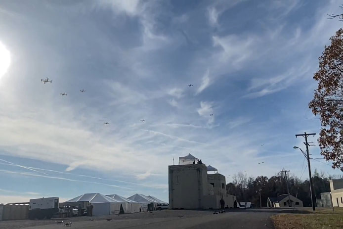
Raytheon BBN-led team recently supported DARPA’s fifth OFFSET program field exercise. (Photo: Raytheon)
Raytheon Intelligence & Space, a Raytheon Technologies business, recently supported the fifth OFFensive Swarm-Enabled Tactics (OFFSET) DARPA program field exercise.
Using integrated swarm technology developed by a Raytheon BBN-led team, a single operator successfully controlled a swarm — composed of 130 physical drone platforms and 30 simulated drone platforms — both indoors and outdoors in an urban setting. Raytheon BBN provides advanced technology research and development with a focus on national security priorities.
During the exercise, the team used a combination of commercial off-the-shelf and custom-built hardware and software to deliver swarm autonomy. This enabled a single or small group of operators to direct and manage the activities of a large swarm of autonomous air and ground vehicles with minimal training.
“Controlling a drone swarm changes the way an operator or group of operators think about the drones,” said Shane Clark, Raytheon BBN OFFSET principal investigator. “Takeaways from this exercise help inform us of the inflection points between utility and manageability.”
Inexpensive Hardware
A key element of the program is the use of inexpensive hardware. Without the powerful computing and sensing capabilities available in larger more expensive platforms, Raytheon BBN needed to create a broad library of simple tactic building blocks used to create plans to accomplish mission objectives.
Raytheon BBN also designed and configured a scalable, modular and decentralized approach to manage a variety of current and future platforms and missions. Whenever possible, the drones collaborate actively to decide how to accomplish a specific mission most efficiently.
“Our software is smart enough to assign drones with the right capabilities to the appropriate set of tasks,” Clark said. “For example, if the task is to surveil a building, multiple drones will be dispatched, with each surveilling portions of the building. The software considers each platform’s sensor capabilities, and tasks drones with downward-facing cameras to surveil the roof.”
Once the drones are deployed, their collaboration allows them to understand what parts of a building have been explored and where the gaps are. They then autonomously select how to fill in those gaps.
Virtual Reality Interface
To tackle the complexities of human swarm interfaces, the Raytheon BBN team created a virtual reality interface in addition to traditional camera views. It takes feeds from all the swarm assets to create an interactive virtual view of the environment.
“You can look behind the building to access a view of drone locations, for example, and use the virtual reality environment to test and see if your mission is viable,” Clark said. “We also developed a speech interface with the operationally deployed Tactical Assault Kit, or TAK, integration capability that enables the operator to act quickly while maintaining situational awareness over many systems simultaneously.”
The Raytheon BBN-led team includes Smart Information Flow Technologies, or SIFT, and Oregon State University. The team is contracted by DARPA to demonstrate its swarm capabilities during Army Expeditionary Warrior Experiment 2022 taking place in February to March, and hosted by the Army Maneuver Battle Lab.
Seoul Robotics has introduced the Level 5 Control Tower (LV5 CTRL TWR), a mesh network of sensors and computers on infrastructure that guides vehicles autonomously without requiring that sensors be placed on individual vehicles.
The technology is in the early stage of commercial deployment to automate last-mile fleet logistics at BMW’s manufacturing facility in Munich. The system has the potential to transform operations for a wide range of business applications, from vehicle distribution centers to car rental companies and trucking logistics.
Seoul Robotics is a 3D perception solution company using deep learning artificial intelligence (AI) to power the future of mobility,
By placing sensors equipped with 3D perception software around vehicles — traffic lights, buildings and highway overhangs — the system can fully capture the environment and communicate with other sensors and the 4/5G systems that come standard on vehicles.
The LV5 CTRL TWR collects all the 3D data, and then automates vehicles accordingly using V2X communications.
“Level 5 mobility has been proven to be more challenging to achieve than expected, until now,” said HanBin Lee, CEO of Seoul Robotics. “LV5 CTRL TWR has massive potential to fuel autonomous mobility, and we are thrilled to continue expanding upon the implementation of this technology with BMW and other partners.”
“Ultimately, these systems will be deployed in additional public and commercial settings, powering aspects of our everyday lives, such as autonomously navigated parking and public transit,” Lee said. “With LV5 CTRL TWR, this future is closer and more accessible than ever.”
The collaboration with BMW leverages hundreds of connected lidar and 3D sensors on infrastructure to automate newly manufactured vehicles within factories and vehicle distribution centers without any human involvement. By making this process autonomous, automakers like BMW can increase operational efficiencies and safety within automotive logistics.
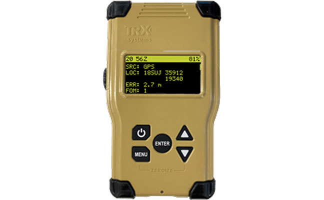
TRX Systems, developer of NEON GPS-denied location solutions, has been selected by the U.S. Army to provide a next-generation Dismounted Assured Positioning, Navigation and Timing (PNT) System (DAPS).
The TRX DAPS solution employs a lightweight soldier-worn device that enables dismounted warfighters to successfully conduct operations when operating in GPS challenged, degraded or denied environments.
Military equipment can be the subject of enemy electronic attacks, potentially resulting in a loss of location awareness that can put army missions at increased risk. The TRX DAPS solution alerts the users when their position isn’t reliable and then leverages multiple sensors and timing sources to provide the best soldier position possible within the GPS-degraded operational environment.
The solution — designed to replace the Defense Advanced GPS Receiver (DAGR) — supports both a standalone configuration and integration with the Nett Warrior ensemble. It combines inputs from small, body-worn sensors and other sources to provide assured PNT while meeting the size, weight and power (SWaP) needs of dismounted soldiers already physically burdened with heavy equipment loads.
TRX Systems has delivered GPS-denied location technology to thousands of military, public safety and security users worldwide.
“Maintaining assured PNT is paramount to the situational awareness of U.S. warfighters in the many conflict zones around the world,” said Carol Politi, president and CEO of TRX Systems. “When initial units are fielded in mid-2022, the TRX DAPS solution will deliver a balance of the highest possible level of integrated PNT capabilities with the smallest package that can be fielded for dismounted warfighters.”
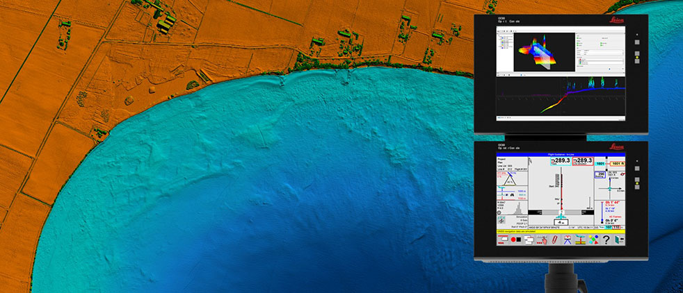
Leica Chiroptera 4X bathymetric data with Leica OC60 screen visualizing objects in near real-time during the flight. (Photo: Hexagon)
Hexagon is partnering with Airbus on a near-real-time airborne bathymetric lidar surveillance system.
Hexagon’s Geosystems division is partnering with Airbus to integrate two Leica Chiroptera 4X bathymetric lidar sensors for maritime surveillance into the C295 MSA, Airbus’ Maritime Surveillance Aircraft.
Hexagon’s new technology enables detection of underwater objects in near real time, a significant innovation in the airborne bathymetry industry, the company said.
The lidar system was developed to meet Airbus’ requirements and will first be implemented in two C295 MSA craft purchased by the Irish Air Corps. The aircraft are due for delivery to Ireland in 2023.
The system’s unique object-detection feature enables real-time lidar data visualization and analysis during flight. Being able to locate the precise position of an object allows operators to preview and analyze information captured below water immediately — a process that previously could take several days.
“When we acquired the C295 MSA, we explored various sensors to be added to our fleet, including bathymetric and topographic LiDAR. Airbus introduced us to the Chiroptera 4X, which now meets all our requirements,” said Stephen Connolly, captain of the Irish Air Corps. “The combined bathymetric and topographic lidar sensor will provide us with more details than ever before. Detecting objects close to real-time and having a clear picture of underwater activities will allow us to report directly to the Mission Support Centre on the ground and act faster to perform our duties more efficiently. The Chiroptera 4X will provide an overall better solution for the coastal maritime domain.”
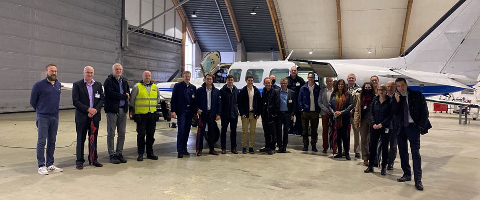
Airbus and Irish Air Corps visited Hexagon’s R&D and production facility in Jönköping, Sweden, in September for the factory acceptance test. (Photo: Hexagon)
Infineon Technologies AG and Deeyook are collaborating on location solutions. Deeyook, a location-as-a-service (LaaS) company, has patented a tracking solution to determine indoor and outdoor locations of items, assets and employees.
The companies fused Deeyook’s ultra-precise algorithms into Infineon’s low-power AIROC Wi-Fi portfolio to enable an accurate, passive, ubiquitous and efficient location solution.
Deeyook specializes in wireless signal processing applicable to incumbent Wi-Fi/4G/5G modem firmware versions. The firmware extracts angles of wireless transmissions (direction finding, or DF), for commercial wireless tracking. Deeyook’s tracking capabilities are ultra-precise, providing location information within 10 cm/4 in, passively exploiting the install base of 1.7 billion wireless access points worldwide.
“There are many challenges when companies implement real-time location systems, primarily because tracking solutions, such as RFID, are not really ubiquitous. This is particularly acute with GPS, which has many shortcomings,” said Gideon Rottem, CEO and co-founder of Deeyook. “We created Deeyook to address these challenges — technology that is ubiquitous and can track things with the utmost precision indoors, outdoors and in bad weather. We are excited to work with Infineon because its AIROC Wi-Fi portfolio is reliable and power efficient.”
“Infineon’s mission is to make the world an easier, safer and greener place with our technologies through smart, connected devices,” said Sivaram Trikutam, senior director, IoT Compute and Wireless, Infineon Technologies. “These new IoT solutions support multiple location tracking technologies. Previously, Wi-Fi was not considered a viable option due to its power demands, while additionally, real-time locating system (RTLS) deployments required businesses to utilize custom solutions with costly infrastructure, engineering and labor-intensive installation.”
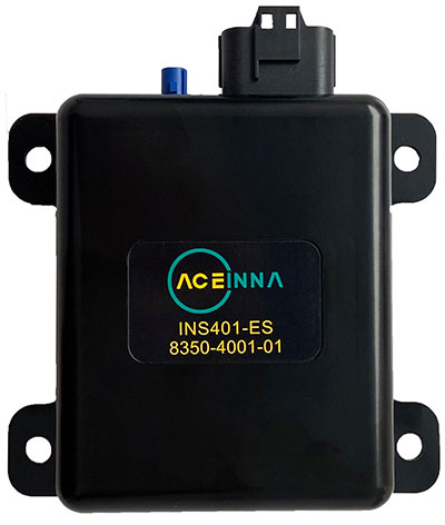
Aceinna Inc. has announced the INS401 INS and GNSS/RTK, a turnkey solution for autonomous vehicle precise positioning. Aceinna made the announcement at the Consumer Electronics Show (CES) taking place this week in Las Vegas.
The INS401 is part of Aceinna’s new product portfolio that provides high accuracy and high integrity localization for developers and manufacturers of advanced driver-assistance systems (ADAS) and autonomy solutions for vehicles of all types.
The INS401 is a high-performance inertial navigation system (INS) with a dual-frequency GNSS receiver enabled with real-time kinematic (RTK). It also features triple-redundant inertial sensors and a positioning engine. It is designed for use in Level 2 and higher ADAS and other high-volume applications requiring precise position information.
The INS401 provides centimeter-level accuracy, enhanced reliability and superior performance during GNSS outages. The dead-reckoning solution delivers strong performance in GNSS-challenged urban environments.
The INS401 is specifically developed for automotive applications using automotive-qualified components and is certified to ASIL-B level according to ISO26262.
INS401 is small, compact and turnkey with a rugged aluminum housing. It includes everything needed for design and development of a robust navigation system with a flexible platform enabling easy customization for fast time to market. The included integrity engine guarantees zero performance failure.
“Based on a decade-long history in ADAS and safety applications, Aceinna is ready for today’s and future autonomous mobility applications,” said Wade Appelman, president and COO of Aceinna. “The INS401 is our next step forward, delivering complex INS/RTK technology to mass markets with turnkey products.”
TerraStar X corrections technology enables lane-level accuracy with under one-minute convergence for consumer and automotive-grade GNSS receivers
Hexagon’s Autonomy & Positioning division has partnered with Chinese positioning company Dayou to bring TerraStar X technology to the Chinese market. TerraStar X provides fast precise point positioning (PPP) corrections for autonomous vehicles and has mass-market use such as in smartphones.
The partnership enables Hexagon and Dayou to provide consistent positioning solutions globally, including North America, Europe and China, so original equipment manufacturers (OEMs) can deploy the same design worldwide.
The GNSS corrections generated from TerraStar X technology enable lane-level accuracy with convergence in under a minute for consumer and automotive-grade GNSS receivers, supporting advanced driver-assistance systems (ADAS), autonomous applications, safety-critical applications, mobile-phone applications and more.
TerraStar X technology delivers corrections using industry-standard formats compatible with mobile networks and enabling efficient delivery of corrections to millions of end-user devices. Through the partnership with Dayou, OEMs can now deploy the same high-accuracy solution across China as in North America and Europe, while having access to local sales, support and technical resources.
“This partnership provides a way for global companies to leverage TerraStar X technology to bring consistent lane-level positioning around the globe,” said Sara Masterson, director of positioning services at Hexagon’s Autonomy & Positioning division. “With its hardware-agnostic design, industry-standard format and delivery of corrections, this technology opens up the possibility of precise positioning for a multitude of new mass-market applications for customers to use one software positioning solution on all platforms worldwide.”
“Dayou is excited to be working with Hexagon in China to bring this next level of positioning technology to market,” said Han Jianxin, chief executive officer at Dayou. “High accuracy positioning used to be limited to expensive equipment and niche markets like survey and mapping. With TerraStar X technology, everyone can have the benefit of more accurate positioning, opening up new applications ranging from autonomous driving and freight to regular smartphone users moving from point A to B.”
Test Regions Expand to China
Using Dayou’s local infrastructure to calculate ionosphere corrections, TerraStar X technology ensures that fast convergence to lane-level and sub-meter accuracy is available when needed.
Engineering development test areas are available around the world to support large-scale programs with functional safety requirements. With these test regions now expanded to China, the partnership with Dayou marks a significant milestone to bring Hexagon’s TerraStar X technology to a global scale.
China Dayou PI is a Chinese company invested in by China Intelligent and Connected Vehicles (Beijing) Research Institute Co. Ltd. for high-precision positioning service and solutions based on GNSS, INS and HD map technology.
Tim Burch is a contributing editor to GPS World’s Survey Scene newsletter, authoring columns six times a year.
Burch is a professional land surveyor (PLS) licensed in Illinois and Wisconsin. He has been involved with NSPS for more than 20 years as secretary of the board of governors as well as the board of directors, NSPS vice president, a member of the Certified Survey Technician Board, Joint Government Affairs and American Land Title Association (ALTA)/NSPS Land Title Survey committees. Along with content contributor for NSPS social media, he is creator and producer of the NSPS podcast “Surveyor Says!” and a contributing writer to the NSPS newsletter “News and Views.”
Burch has been involved with the land surveying profession for more than 30 years and has represented NSPS at numerous functions and conferences. He has provided testimony on behalf of the profession at both the state and federal levels as well as helping establish a partnership with “Get Kids into Surveying.”
He is currently chair of the International Federation of Surveyors (FIG) Working Group 1.1 (Professional Ethics) and is chair-elect for FIG Commission 1 (Professional Standards).
Burch succeeded Curt Sumner, who was executive director for the past 23 years.
Another year has come and gone. The global pandemic of COVID-19 is still upon us, and while we have experienced peaks and valleys of controlling the virus, it has radically changed our lives in many ways.
The surveying and geospatial professions have not been immune to the effects of the pandemic. It has forced many practitioners to modernize the means and methods to their workflows and products.
In this edition of Survey Scene, I consider the changes and accomplishments of 2021, and take a look ahead at events and technological advances to come.
2021: The Road We Traveled
Despite the pandemic, technology within the geospatial professions grew at a rapid pace, with new equipment and features. From the air to the seas, geospatial data-collection capability increased in varying ways across the differing environments.
Unmanned Aerial Systems (UAS)
The technological explosion of unmanned aerial vehicles (UAV) shows no signs of slowing down and manufacturers remain hard at work developing new designs for longer flights and increased capabilities. Lidar has emerged as the “hot” remote-sensing method for many users of UAS as an additional tool for photogrammetric capabilities, yet camera specs continue to grow well beyond the 20-megapixel expectation of recent years. These increased capabilities were not possible simply because of the amount of data generated by the methods, but previous issues and limitations with computing power and data storage have turned a significant corner in software performance and affordability.
In addition to the implementation of lidar, further developments in multirotor and fixed-wing UAV design continue to improve the performance and capabilities of the data-collection task. Many companies are growing their fleets to include both types of UAVs for varying conditions and applications.
Unmanned Ground Vehicles (UGV)
The sector with the most surprising developments has to be the unmanned ground vehicle (UGV) — but not for the reasons most would have predicted. We have been introduced to several products based upon remote-control vehicles utilizing GNSS positioning over the past few years, so it was expected for that trend to continue and grow.
To say the industry was taken aback when Leica partnered their BLK scanning technology with the Boston Dynamics new robot “Spot” would be an understatement. Trial projects and testing is ongoing, but the concept of autonomous data collection by a robotic “dog” is an intriguing concept, especially in environments where human presence is dangerous.
Unmanned Surface Vehicles (USV) and Unmanned Underwater Vehicles (UUV)
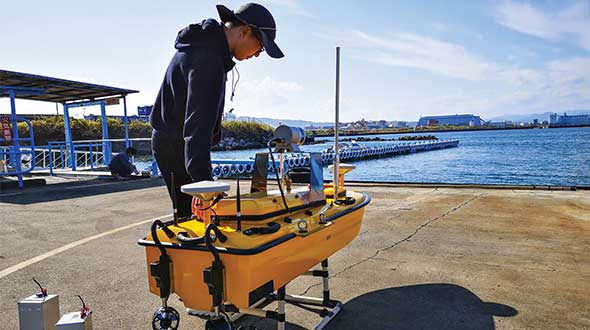
The last two autonomous vehicles used by geospatial professionals saw significant advancements as well, and are seeing increased use for many water-based remote-sensing projects. For many bathymetric surveyors, the small-footprint unmanned boat using GNSS positioning and conventional fathometer has been a game changer.
In addition to not investing large sums in a conventional boat, a USV is able to navigate many places and shallower depths than its larger counterparts. Like its airborne and ground cousins, battery life and advancing designs are creating more capability for data collection and remote sensing. The old saying “the sky is the limit” for emerging technologies does not apply to unmanned vehicles, as their use is being seen in almost every environment.
Weichao Liu, a member of CHC Navigation’s technical support staff, prepares to launch an Apache 6 USV. (Photo: CHC Navigation)
Professional Societies/Events/Education
As the calendar pages turned from 2020 to 2021, our world had begun a slow ride back to normalcy with the introduction of several variations of a vaccine for COVID. Some communities chose to return to face-to-face meetings, while others remained cautious and continued with remote communications. Here is a recap of how various organizations remained active within the professional community:
National Society of Professional Surveyors (NSPS) and its state affiliates: In-person resumption for some, while most continued with hybrid and/or remote communication methods.
International Federation of Surveyors (FIG). Annual working week was held remotely.
Council of European Geodetic Surveyors (CLGE). Various meetings held in-person and remotely.
Global Surveyors Week. Hosted by CLGE and held remotely.
NGS Seminars. A variety of seminars throughout the year held online.
Survey & GIS Summit. Joint conference hosted by NSPS and URISA held online.
Intergeo. Return to in-person with hybrid option.
Educational institutions worldwide struggled with returning to in-person classes, yet technology has allowed for remote communication and continued teaching. While many may still see remote learning as a hindrance, improved technology and communication methods have allowed us to continue to learn, work and simply converse with others. Without these tools, life as we know it would be impossible.
Legislation and Government
While much of the attention within legislative arenas was on social and economic issues, the geospatial community continues to monitor several items that potentially have a large impact on the profession.
The continuing saga of Ligado (formerly known as LightSquared) is still playing out, despite the outcry by many industry users of GPS technology. The Federal Communications Commission (FCC) authorized Ligado to begin construction of its new 5G communications technology and denied any stays to this order. Many groups, including coalitions of geospatial data users, continue to protest the authorization by the FCC.
In December 2021, the airline industry, along with Boeing and Airbus, expressed its concerns over the implementation of the new communication technology and the potential interruption of GPS and radio guidance for aircraft. Only time will tell if efforts to derail the installation and use of the new 5G communication band will be successful
Elimination of the professional license requirement for surveyors is quite dangerous and foolish.
Another large issue on the horizon for surveying and geospatial professionals is licensure deregulation. Currently, each state in the U.S. is responsible for licensing and oversight of professionals as established within their statutes. Several consumer groups have begun to petition a number of states to eliminate licensing as a barrier to entry into a given profession, including surveying. They also cite the cost of regulating the professions as an unnecessary expense to the residents of their states.
Unfortunately, these groups are shortsighted about the education and training required to become licensed within each profession to protect the public they serve. While the costs associated with purchasing the technology needed for the profession continues to decline, the expertise and training needed is on the rise. Elimination of the professional license requirement for surveyors is quite dangerous and foolish.
2022: The Road Ahead
As we look ahead, we are still facing many challenges left over from the past few years. Obviously, the COVID-19 pandemic will continue to twist and turn with new variants, enhanced vaccines and adjustments to many aspects of our lives. Because of technology and much different lifestyles from earlier pandemics, we are continuing to adapt to environmental changes: much of business goes about as close to “normal” as possible.
One could say that creativity and innovation has increased because of the pandemic and probably not get much of an argument. So where do we see technology and the geospatial profession heading during 2022?
Technology Evolution
More people are using technology and computing power than ever before and in ways probably not considered even 10 years ago. Until recently, data — especially personal information —has been considered off-limits for public consumption. Only governments were allowed to obtain scores of data to help keep track of literally everything.
Once geospatial technology came along, the game changed to include a location or positional component to a dataset. Now data can be saved to include a place and time for a particular piece of information if necessary.
Databases continue to grow with computing and software enhancements, storage increases and expanded network capability. So where are all of these cutting edge technologies taking the surveying and geospatial professions? Here are ways that continuing technological improvements are advancing our capabilities.
Open-Source Data
While in the past data was typically considered proprietary, many of the datasets used by geospatial professionals do not contain personal information. This information is simply physical location data for improvements and infrastructure that can be shared openly with no risk of compromising personal security.
Examples of open-source data cover many subjects, including shape files of physical objects, lidar and contour data of existing topography, and aerial imagery of the world we live in. It can also include data such as traffic counts, air-quality reporting and general population data.
Much of this data is secured using public funding, but it is not able to be readily shared because of database size limitations. Increases in technology have allowed this information to be shared more freely, and that has given professionals more information in which to better design infrastructure.
Artificial Intelligence (AI) and Machine Learning
Trainable technology is nothing new, but the computing power behind it has rapidly increased to make it a formidable challenge to our future workforce. Besides robotic machinery, sophisticated software is being developed to analyze various datasets and electronic mediums to “learn” about the information it contains.
For example, AI is being used to analyze photographic imagery and lidar datasets to determine characteristics of various elements within the work product. The software can now establish a painted parking line and draw a vectorized line in all places where it finds the same pixelated areas.
This same process is used to determine curbs, buildings and other improvements with an efficiency of which the human surveyor on the same site isn’t capable. While not foolproof, the technology has great potential and can shrink production time drastically. As programming continues to become more robust in determining the computer’s abilities, we should not bet against this market sector achieving anything but rapid growth. Couple these advancements with the shrinking workforce, and we will continue to see much more from this technology.
High-Performance Computing via Cloud Networks and Storage
Before the personal computer (circa 1980), most data processing was completed on a mainframe using terminals and primitive networks. No true computing brainpower was sitting on the user’s desk; the keyboard and monitor were simply conduits to the main processing computer typically housed in a large room somewhere in the building.
Fast forward to today’s environment, in which everything can be considered a computer. As many have noted, your current smartphone has more computing power than we used to reach the Moon. (The Apollo guidance computer had 4 KB of RAM and a 32-KB hard disk; it measured 24 x 12 x 6 inches and weighed 30 kg). Computing power at your fingertips has never been greater, but our improving technology is making today’s current data analysis seem like child’s play.
Enter the world of cloud computing and storage. If you live in a major metropolitan area, you have likely been witness to nondescript buildings being constructed with lots of transformers and electrical grid units surrounding them. These facilities are data centers and are being built at breakneck speed by Google, Microsoft, Facebook, Amazon and others to provide cloud computing and storage for the masses.
The cloud computers offer unmatched processor speed, nearly unlimited storage and reduced IT management costs. Large datasets being analyzed for specific algorithms can utilize cloud computing at a fraction of the cost of maintaining a personal computing system and network. It also allows the flexibility to work from literally anywhere in the world, yet have a consistent computing presence where you are. The big downside is that one is dependent on a reliable (and fast!) connection, as well as needing a comfort level with someone else having access to your data.
Other major areas of technology that will see improvement this year include 3D visualization (AR & VR), remote sensing, massively online open courses (MOOC) for higher learning, blockchain utilization, and an increase in the number of devices using internet of things (IOT) programming. The key to staying in front of these technologies is to remain curious and never stop learning!
A Personal Note for 2022 and Beyond
Like many jobs in this age of advancing technology and automation, surveying is quickly becoming an endangered profession. There are many facets in our everyday lives that are the responsibility of a surveyor, but the number of practitioners is dwindling. The pandemic may have turned our world upside down for many reasons but for surveyors and geospatial professionals, it increased our visibility and workload. Attrition will claim many within our ranks over the next several years, so we must find a way to prolong our profession through all avenues.
Tim Burch
With this in mind, I am proud to announce my appointment as the new executive director of the National Society of Professional Surveyors (NSPS). My years in the private sector have provided me with a broad view of where we face professional challenges, so transferring into an advocacy role will allow me to help solve those challenges.
It will be my honor to work with our organization to recognize the threats lying ahead, not just for surveyors but for many other geospatial professions and occupations. We also recognize that inclusion is a key component to creating diversity, as technology does not see a difference in nationalities, races and genders. The future of surveying is very bright, and NSPS is continuing to lead the way in creating a positive career path for our future surveying and geospatial professionals.
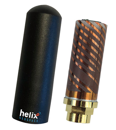
Helix builds precision GNSS antennas that enable product designers to create small, accurate positioning, navigation and timing (PNT) synchronization products that defend against vulnerabilities and threats. Helix is also developing its antennas to provide navigation for autonomous vehicles.
Helix’s patented DielectriX antennas are targeted initially to receive PNT signals from GNSS (GPS, Galileo, GLONASS, Beidou) constellations, and the Satelles STL (Satellite Time and Location) signals delivered over the Iridium constellation as well as Iridium’s voice and data network.
Future antenna variants will support low-Earth orbit (LEO) PNT services being planned and built by private companies, as well as government agencies, the company said.
DielectriX antennas discriminate true satellite signals from multipath signals, interference and jamming, delivering high performance in a compact and rugged form factor. Helix’s customers include defense, automotive, aerospace and critical infrastructure companies.
Helix previously raised £2.5 million from UKI2S and angel investors, and has participated in Wayra UK’s Intelligent Mobility Accelerator programme and Seraphim Capital’s Space Camp Mission 6. Helix also received additional grant funding for advanced antenna development from the European Space Agency, and for anti-jamming/spoofing technology from UKI2S.
Tokyo-based Kudan Inc. demonstrated the use of a 3D-lidar simultaneous localization and mapping (SLAM) device to create a sharp point cloud without using an external GNSS receiver or inertial measurement unit (IMU).
Kudan is a research and development company specializing in algorithms for artificial perception. For the demonstration, Kudan used its localization and mapping software Kudan 3D-Lidar SLAM, or KdLidar.
Using an Ouster OS1-64 lidar and only its internal IMU, Kudan demonstrated how it can create a crisp high-resolution point cloud with KdLidar.
For the demonstration, the company used a handheld scanner with the Ouster lidar. Handheld scanners can introduce noise and fuzziness in typical point clouds generated from SLAM because of natural vibration, movement and limited field of view. However, Kudan was able to capture sharp wall definition of buildings and structures, as well as the fine detail of powerlines.
While the demonstration highlights KdLidar’s basic performance without any external sensors, the company said its algorithms can further increase the performance and quality of lidar-based scanners by fusing GNSS receivers and external IMUs or inertial navigation systems.
For navigation and control of any robotic or autonomous outdoor system, GNSS and inertial navigation systems (INS) are key components. Inevitably, the question arises: Should you build your own custom solution or integrate an available GNSS/INS combined solution? What would give you the best performance, while keeping the total cost of ownership (TCO) to a minimum? The TCO is also known as the “long-term price” and is defined as the purchase price plus the costs of operation over time.
Xenomatix is a company offering automotive solutions based on lidar technology. With eight years of innovative experience, Xenomatix has installed a pre-integrated GNSS/INS receiver on its latest lidar product, achieving high GNSS/INS performance with minimal TCO.
In an integrated INS/GNSS receiver, the GNSS receiver provides positioning with centimeter-level accuracy. The other component is a micro-electromechanical inertial measurement unit (MEMS IMU), which measures 3D orientation in terms of heading, pitch and roll angles with sub-degree precision. For its latest product XenoTrack, Xenomatix chose an INS called XenoAsterx based on the AsteRx SBi3 from Septentrio, which it integrated alongside its lidar to collect road-quality data to the smallest detail.
From an in-house solution to a pre-integrated system
Three years ago, when Xenomatix started developing its new lidar road-inspection system, the company had a GPS receiver, an IMU and an odometer as accompanying sensors. The company wanted to expand into new markets of road inspection in accordance with international standards, and so it needed to improve its components to take the overall performance of its system to the next level with RTK high-accuracy positioning.
To achieve this, while saving time and costs, Xenomatix acquired an AsteRx SBi3 INS/GNSS receiver, which allowed it to focus on its core lidar technology and sensor-fusion algorithms.
This off-the-shelf INS/GNSS solution provided all the high-accuracy positioning and orientation information Xenomatix needed, while eliminating most costs of development, maintenance and support. The new receiver allowed them to drive for miles, without any offset in positioning, something impossible with the previous GPS receiver.
The unique technology from Xenomatix stitches images by using lidar point-cloud overlays. However, when the car is moving fast, this overlay is smaller. The pre-calibrated GNSS/INS extends system performance by allowing stitching even when driving at higher speeds.
“If we start driving and we stitch the road for tens of kilometers and we come back to the same starting point, then we see an offset of only a few millimeters,” said Filip Geuens, CEO, Xenomatix. “This is for us the strongest proof of accuracy and reliability of the GNSS sensor.“
Why pre-integrated GNSS/INS offers better value
The pre-integrated GNSS/INS allows XenoTrack to collect road data even at higher speeds. (Credit: Septentrio)
A pre-integrated GNSS/INS solution — versatile enough to fit into virtually any autonomous or mapping system — offers the best value in the long run for the following reasons.
Better performance. The manufacturer of a GNSS/INS solution specializes in fusing the GNSS receiver and the INS in an optimal way. To accomplish this, the sensors are synchronized and their output run through a sophisticated Kalman filter algorithm. The fused device is then fine-tuned for optimal operation under various conditions. Finally, it is extensively tested and validated.
While being used by numerous customers and in varying applications, the GNSS/INS solution proves itself on various levels such as accuracy and robustness. This results in superior performance, even in the most demanding environments.
After installing the AsteRx SBi3 GNSS/INS system, XenoTrack was able to extend its functionality to inspect longer distances of roads at higher speeds. The AsteRx SBi3 operates reliably, even in challenging environments, such as when driving near high cliffs or under bridges.
Less development time and lower costs. When building a system, the development time is usually about one year employing two full-time GNSS/INS specialists. Hardware components need to be integrated and synchronized, while various interfaces and the Kalman filter need to be implemented. Additional features may be developed, such as velocity input as well as tools for validation, before the intricate step of performance fine-tuning. Finally, additional testing efforts are needed for verification and validation of the device.
On the other hand, a pre-integrated GNSS/INS system with easily accessible interfaces and flexible configuration ensures quick installation, meaning the product is ready within weeks.
Lower maintenance costs and support. Certain high quality pre-integrated GNSS/INS receivers are future-proof — ready to use new GNSS satellite signals and services as soon as they become available. An example of such upcoming service is the Galileo OSNMA anti-spoofing authentication.
Some receiver manufacturers such as Septentrio also offer continuous product improvement in the form of free firmware updates. A system developed in-house, on the other hand, needs continuous investment to maintain its competitive edge.
When issues occur, Septentrio also offers local worldwide support, with experienced application engineers ready to solve GNSS, INS or coupling issues that could halt the production process. For example, when Xenomatix discovered that its GNSS/INS was not working optimally in a certain environment, the company called Septentrio. Within days application engineering experts who analyzed the logged data found the source of the issue and proposed a solution.
Focus on core technology. When the budget is limited, choices need to be made about where to focus the efforts. When a company saves on GNSS/INS development, more can be invested in core technology. This means avoiding any lost-opportunity costs and optimizing margins.
Building your own is not always the best option
Acquiring a pre-integrated GNSS/INS receiver allowed Xenomatix to have a superior and affordable product with a competitive edge. AsteRx SBi3 increased the performance of the XenoTrack mapping system, while a short integration period allowed a faster time-to-market.
Xenomatix also benefited from low maintenance costs, keeping overall TCO to a minimum. Since the company was not spending time developing a custom GNSS/INS system, it could focus fully on its core technology. This allowed Xenomatix to take its business to the next level at a high pace.
Award-winning technology
In November 2021, the XenoTrack road scanner, with AsteRx SBi3 inside, was announced a winner of the IRF Global Road Achievement Award for its innovative road scanning and surveying solutions.