Upgraded range of synchronization solutions now includes enhanced PNT resiliency against jamming and spoofing attacks and cyberthreats
ADVA has announced a new software release of its core and edge timing technology, to provide higher levels of positioning, navigation and timing (PNT) security and resilience to synchronization networks. The new release follows the Resilient PNT Conformance Framework issued by the U.S. Department of Homeland Security (DHS).
The upgraded series of PTP grandmaster clock solutions now enables operators to automatically harness public key infrastructure. Along with enhanced certificate management, this delivers more robust security and removes complexity, the company said.
ADVA’s core and mid-sized PTP grandmaster devices now also integrate enhanced aPNT+ technology, providing advanced jamming and spoofing detection as well as mitigation with automatic switchover in the event of cyberattacks.
The software replaces costly hardware devices previously used for PNT protection and achieves enhanced DHS Level 4 Resiliency in PNT self-survivability, the highest in the industry. The new software release also supports 100 Mbit/s over fiber for interconnectivity with optical timing channels from third-party vendors as well as support for PTP profiles for a wide range of industries.
“Today’s timing networks require greater accuracy than ever before. But mission-critical national networks need improved resilience and security as defined by the latest standards. With our trusted PNT assurance solutions, we’re providing the GNSS protection and cybersecurity that today’s operators need to meet current and future challenges,” said Gil Biran, GM of Oscilloquartz, ADVA. “From phase synchronization in critical national infrastructure to traceable timestamping in financial networks, highly precise and protected timing is key to successful operations. This upgrade sets a new standard for secure synchronization and delivers it to more networks than ever before.”
The new 11.1.1 software release features upgrades to ADVA’s comprehensive range of Oscilloquartz edge timing products, the OSA 5412/22 series, as well as its core synchronization devices, the OSA 5430/40 series. The solutions now provide multi-layered security for synchronization infrastructure through improved certification management and PKI.
As part of ADVA’s intelligent and scalable assured PNT platform, the ADVA aPNT+, the solutions also feature innovation for detection of spoofing and jamming as well as countermeasures to prevent service disruption. With PTP capabilities for new verticals, including the PTP broadcast profiles (SMPTE ST-2059-2/AES67), the new release will bring precise, reliable synchronization to many new customers.
The U.S. Defense Logistics Agency has executed a $316 million contract option for BAE Systems’ advanced M-code GPS modules, raising the contract funding to $641 million.
The modules provide dependable positioning, navigation, and timing for ground troops, vehicles, aircraft and precision munitions. The contract will ensure the availability of Common GPS Modules (CGM) for advanced military GPS receivers with anti-jamming and anti-spoofing capabilities that enable operation in contested environments.
Under the contract option executed in November, BAE Systems will manufacture CGMs for future ground, airborne and weapon GPS receivers for the U.S. Department of Defense (DoD) and its allies. The award builds on a May $325 million contract and enables BAE Systems to continue to meet domestic and international demand for Military GPS User Equipment (MGUE) Increment 1 M-Code modules in GPS receivers through the end of the decade.
“Military operations require assured positioning, navigation and timing, and our customers are shifting to M-code to harden their GPS receivers against jamming and spoofing,” said Frank Zane, Navigation and Sensor Systems business development director at BAE Systems. “We’re ready to meet this need today with secure, reliable M-code GPS solutions, and we’re developing the next-generation of solutions to stay ahead of the threat.”
BAE Systems is delivering two advanced M-code GPS receivers: the Miniature Precision Lightweight GPS Receiver Engine – M-Code and the NavStrike-M GPS receiver.
Deliveries of the ultra-small MicroGRAM-M are expected in 2022, and deliveries of the Strategic Anti-jam Beamforming Receiver – M-Code are expected in 2024.
InfiniDome, Honeywell and Easy Aerial have successfully demonstrated their new Robust Navigation System for UAVs. The system integrates GPS anti-jamming technology, a radar velocity system and an inertial navigation system into a resilient system that enables UAVs to safely operate in GNSS-challenged or denied environments.
UAV developers or end users currently try to solve the problem of GNSS jamming either by creating “safe landing protocols” in GNSS-challenged environments or by adding various types of sensors such as lidar or optical. These sensors may not work in certain scenarios, such as when flying too high, too low or too fast; in fog or darkness; or above the ocean.
The Robust Navigation System, jointly developed by Honeywell and infiniDome, tightly pairs the GNSS-based UAV-tailored Honeywell Compact Inertial Navigation System (HCINS) with infiniDome’s GNSS anti-jamming technology (GPSdome), integrated with Honeywell’s Radar-based Velocity System (HRVS). It can be installed on almost any UAV, providing continuous, accurate navigation data in GNSS-challenged or fully GNSS-denied environments.
The companies demonstrated the new navigation system for Israeli defense prime contractors and drone companies and government end-users at a testing range in the center of Israel. The system was tested against two military-grade directional jammers of different types and bandwidths on customized Osprey Hexa-copter with a PixHawk 2.1 Cube Black flight controller. The GPS 1 input was a Here2 standard GNSS receiver and antenna module; the GPS 2 input was the Robust Navigation System (GPSdome 1.03 + HCINS + HRVS).
A customized Osprey Hexa-copter demonstrated the Robust Navigation System. (Photo: InfiniDome)
The goal of the demo was to show that a UAV in a GNSS-challenged environment (single direction of jamming) and fully denied environment (multiple directions of powerful jamming) can perform autonomous tasks accurately and safely without the pilot needing to assume manual control. This included beyond-visual-line-of-sight flights.
Each test was designed to be more difficult than the preceding one and would be executed only if the latter was successful. The intention was to find the barrier at which the system fails.
The first test was maintaining the UAV height (AltHold), position (PosHold) and Loiter autonomously under jamming conditions, followed by a simple point-to-point autonomous task under the same jamming conditions.
The UAV then performed a fully autonomous task including executing a 10-point polygon and returning to the same position accurately under the same jamming conditions. Finally, the UAV was tested for lift-off performance, executing the full polygon and landing under the jamming conditions.
Protected by the Robust Navigation System, the UAV passed all planned tests.
UMSZ6 module allows high-accuracy vehicle positioning to within 50 cm without correction data
Photo: Alps Alpine
Alps Alpine and Furuno Electric Co. Ltd. have jointly developed the UMSZ6 series GNSS module, providing high-accuracy positioning to within 50 centimeters without having to use position correction data.
On typical 3-meter-wide roads, the module reliably enables vehicle positioning down to the lane level, a requirement of various V2X applications, and makes possible greater sophistication of autonomous driving functions. This is achieved using a multi-frequency GNSS receiver chip based on Furuno’s Extended Carrier Aiding technology.
The module is compact at 17.8 × 18.0 × 3.11 mm while conforming to automotive-grade specifications. Running costs associated with real-time-kinematic (RTK) base stations, correction data receiving, and correction data use are not needed, maximizing cost performance.
Under the joint agreement, Furuno developed and supplied an original multi-frequency GNSS receiver chip — eRideOPUS 9 (model ePV9000B) — and algorithm. Alps Alpine is the first company to use the chip, with the UMSZ6 series.
Alps Alpine plans to carry out evaluations within a real automotive environment to assess performance and interoperability with V2X and other communication modules. Mass production is expected in 2023.
Trimble’s new GNSS base station gives users improved satellite tracking and remote operation for civil construction, geospatial and agriculture applications
Photo: Trimble
Trimble has introduced the Trimble R750 GNSS modular receiver, a connected base station for use in civil construction, geospatial and agricultural applications. The R750 provides high-accuracy base station performance, giving contractors, surveyors and farmers more reliable and precise positioning in the field.
The R750 can be used to broadcast real-time kinematic (RTK) corrections for a wide range of applications, including seismic surveying, monitoring, civil construction, precision agriculture and more. Access to all available satellite signals provides improved performance and reliability when used with a Trimble ProPoint GNSS rover. ProPoint gives users improved performance in challenging GNSS conditions, with improved signal management.
Featuring a built-in LTE modem, the R750 can provide corrections via the internet, making it easier to extend the range of a base station anywhere with cellular coverage. The built-in modem also provides remote access and management, delivery of email alerts and notifications, and data transfer capabilities between the field and the office.
“The R750 delivers significantly improved satellite tracking and connectivity, while also providing a vastly improved user experience,” said Scott Crozier, vice president of Trimble Construction Field Solutions. “The ability to manage the base station remotely, and to receive status notifications about the unit while in the office reduces downtime and the need to travel to the site. The new Trimble R750 is a game changer, especially for users who manage base stations in remote locations.”
For monitoring applications, the R750 provides precision capabilities for construction and geospatial customers deploying automated systems. Combined with Trimble 4D Control real-time monitoring software, users can capture high-frequency 3D positions for alarming and reporting on movement. The R750 offers multiple communication methods that provide flexibility for customers on how they deploy their monitoring system.
Safran has entered into exclusive discussions to acquire Orolia from Eurazeo alongside the founders and management. Orolia is a world leader in resilient positioning, navigation and timing (PNT) solutions that improve the reliability, performance and safety of critical civilian, military and space operations, including in harsh or altered GNSS environments.
Safran is an international high-technology group, operating in the aviation (propulsion, equipment and interiors), defense and space markets. Headquartered in Paris, France, Safran has a global presence, with 76,000 employees and sales of 16.5 billion euros in 2020.
Orolia has a broad portfolio of technologies across the resilient PNT value-chain with full system capabilities, and is a provider of PNT equipment, simulation and test solutions. Orolia is also providing emergency locator beacons for commercial aviation and military applications.
The acquisition “represents a unique opportunity for Safran and Orolia to extend their resilient PNT solutions, through their remarkable complementarities,” Safran stated in a press release. “With this addition, Safran will be able to build a world-leading position in all aspects of PNT, inertial navigation, time and GNSS receivers and simulators, covering aerospace, governmental and high integrity applications.”
Safran intends to accelerate the development of Orolia under the leadership of CEO Jean-Yves Courtois, and in full collaboration with its teams. “The combination of Orolia and Safran will create a PNT world leader with capabilities that will be unsurpassed in depth and breadth,” Courtois said. “Our perfect complementarity in terms of technology expertise, market presence and geographic footprint will allow us to push further resilient PNT to the next level and to offer our government, aerospace and commercial customers the most advanced solutions they need for their critical operations. Orolia will contribute especially through its world-leading positions in timing, GNSS simulation and emergency location technologies, and through its strong presence in the U.S. market. We are looking forward to working with our new Safran colleagues to advance our common vision.”
Orolia is expected to generate revenues of more than EUR 100 million in 2021 and has approximately 435 employees with facilities in France, the United States, Switzerland, Spain and Canada.
The terms of the deal were not disclosed. The transaction is subject to the usual regulatory approvals. Orolia will be consolidated within Safran’s Equipment & Defense division upon closing, expected around mid-2022.
Russia’s recent threat that it could blow up all the GPS satellites with its new anti-satellite technology (ASAT) should come as no shock to those following space-related events. In the past, China shot down one of its own low-Earth-orbit satellites (LEOS) using a medium-range ballistic missile, and the United States used a modified antiballistic missile to shoot down one of its own spy satellites.
Blowing up satellites, solar flares, ever-increasing hazards from “space junk” and thousands of new satellites in the launch queue all make space a congested and increasingly dangerous place.
Locata Corporation and Ursa Navigation Solutions Inc. (UrsaNav) have announced a technology partnership specifically aimed at providing resilient PNT (positioning, navigation and timing) solutions to national governmental and commercial interests globally. Combining Locata’s high-accuracy local-area and UrsaNav’s very wide-area PNT produces a potent solution that lessens any nations’ dependency on easily disrupted and increasingly vulnerable space-based signals.
Locata has for many years been delivering proven centimeter-level positioning and picosecond-level timing to demanding users including the U.S. Air Force, NASA and globally significant commercial partners. Professional users in demanding industries such as ports, mining, the military, aviation, automotive, logistics, indoor positioning and high-accuracy timing depend on Locata systems every day.
UrsaNav’s eLoran and LFPhoenix technologies provide nanosecond-level timing, meter-level positioning, and short-message-service-like data transmissions at distances often exceeding 1,000 miles over land and 1,800 miles over water. Its two-way low-frequency time and frequency transfer (TWLFTFT) service is embedded in the PNT signal, providing a wireless timing synchronization conduit between any set of transmission sites.
When UTC-synchronized time is injected into any transmission site (node), such as from USNO/NIST, NPL or BIPM, it can then be securely networked to every other node in view. UrsaNav’s patented encryption techniques can be applied to the entire signal or any component.
Combining these proven technologies enables development of national-level terrestrial positioning and timing systems that are resilient, sovereign-controlled, and flexible enough to meet both long haul backbone and local high-accuracy critical infrastructure needs, the companies said, adding that over-reliance on space can be mitigated with built-in failover capability and overlapping coverage.
Many publicly available reports show both Locata and UrsaNav technologies have been tested by the United States and the United Kingdom under extreme GPS jamming and spoofing conditions, and yet they continued to provide the PNT their users require.
The MarRINav Report — funded by the European Space Agency (ESA) and researched over several years by eight top UK/EU bodies — recommended eLoran (UrsaNav) and Locata as terrestrial technologies for protection of UK shipping, ports and other key critical-infrastructure sectors.
The partners agree that a system-of-systems approach for resilient PNT must include a GNSS component, a fiber component, and a robust terrestrial wireless component that can be used to distribute solid PNT over nationally controlled radio frequencies.
The interlocking terrestrial capabilities developed by Locata and UrsaNav are unique in the PNT industry, are easily integrated with other PNT solutions, and can operate in standalone, interleaved, or layered modes — the very definition of a system-of-systems approach. Together, they can provide the core technology platform for purely national or cooperative international PNT services.
Hoptroff’s Traceable Time as a Service to become an option for Orolia’s product portfolio; webinar scheduled for Dec. 15
Orolia and timing solutions provider Hoptroff are partnering to deliver a service combining Orolia’s resilient positioning, navigation and timing (PNT) solutions with Hoptroff’s timing synchronization software.
The collaboration will offer Hoptroff’s Traceable Time as a Service (TTaaS) as an add-on to Orolia’s suite of products, providing precise and verifiable time to customers in enterprise, financial, telecom, utilities, public safety, and other markets where traceable time is critical.
Webinar scheduled
Orolia and Hoptroff will host a joint webinar to discuss the partnership and new resiliency options for customers on Dec. 15 at 12 p.m. EST. Register here.
Hoptroff’s TTaaS offers an additional level of security and precision to meet stringent regulatory and resilient infrastructure requirements by delivering accurate time over the network using a VPN connection over broadband or fiber networks.
The bundled solution will simplify the challenge of getting accurate, traceable time in applications where GNSS access is not available or dependable. It can also serve as an accurate, reliable backup to GNSS to provide a high level of resiliency to timing systems being used in critical infrastructure.
“As industries evolve and computer applications become more complex and widely distributed, it is essential that devices in a distributed process share the same accurate timescale to reconstruct digital events after the fact,” said Tim Richards, COO at Hoptroff. “Network-based traceable timing, such as TTaaS, provides resilient backup to a GNSS installation in the case of signal disruption, monitors the quality of performance of time servers, and keeps a record of this timing quality at a location of the customer’s choice. Our partnership with Orolia means businesses will now be able to back up and monitor physical time servers and virtual servers in the cloud, so that they can be sure they share the same accurate timescale, and they have the records to prove it.”
“The partnership with Hoptroff aligns with Orolia’s resilient PNT strategy by providing a wireline solution to augment its space-based PNT solutions. This allows us to further simplify the challenge customers face when building a highly resilient timing solution,” said Jeremy Onyan, Orolia’s director of time sensitive networks. “By combining Orolia’s anti-jamming and anti-spoofing solutions, high-performance GNSS-based timing products, alternative signals like STL, a local high-quality oscillator, and now a wireline-based TTaaS we have one of the most robust portfolios of resilient PNT solutions in the market. Additionally, with the recent acquisition of Seven Solutions, we are well positioned to extend our capabilities into high-accuracy time distribution.”
Seven Solutions is a global innovator in White Rabbit sub-nanosecond time transfer and synchronization technology. “With the capability to distribute time with little to no accuracy loss, Orolia’s customers using Hoptroff’s TTaaS or other time references such as GNSS can extend that time to other parts of their networks and create a high level of resiliency against potential outages,” Onyan added.
Topcon Positioning Group has announced its MC-Max machine control solution. Based on its MC-X machine control platform, and backed by Sitelink3D — the company’s real-time, cloud-based data management ecosystem — MC-Max is a scalable solution for mixed-fleet heavy equipment environments. It is designed to adapt to owners’ machine control and data integration needs as their fleets and workflows expand.
MC-Max increases processing power, speed, accuracy, versatility and reliability, Topcon said. It can be installed on a full range of dozers and excavators, using the same basic modular components. Modern, redesigned user and product interfaces were developed based on real-world applications and customer feedback and provide a simplified and immersive user experience that allows operators to easily learn the system.
Photo: Topcon
“With MC-Max, we’ve created a solution that is flexible and can continue to grow as a contractor’s needs and capabilities expand,” said Jamie Williamson, executive vice president, Topcon Positioning Group. “This new solution provides improved scalability and precision in the field and offers business owners real-time data integration, connectivity and resource management capabilities across their entire workflow.”
The MC-Max solution offers flexible mounting solutions, as well as optional automatic blade and bucket control for a variety of machines. The system also provides a full battery of positioning technologies ranging from slope control to laser, multi-constellation GNSS, robotic total station and millimeter GPS systems.
MC-Max provides project managers a real-time view of machine positions, activities and onsite progress, and is compatible with a wide range of site communications systems.
Topcon MC-X Platform. The Topcon MC-X Platform is designed to make machine control easy to use and affordable for contractors. The platform ties together mixed fleets by interacting with multiple versions of 3D-MC, providing connectivity to Sitelink3D and taking advantage of the multi-constellation capabilities of GNSS antennas.
Inertial Labs has acquired Memsense, a developer of inertial measurement units (IMUs) and a long-time business partner. Inertial Labs is a developer and supplier of orientation, inertial navigation and optically enhanced sensor modules.
The Inertial Labs and Memsense workforce will address the rapidly evolving needs of global customers. The combined company of more than 100 employees and 500 customers expects to introduce breakthrough technologies at an accelerated pace across high-value areas such as autonomous vehicles, GPS-denied navigation, industrial machines, and aerospace and defense.
In addition, Inertial Labs and Memsense have a strong balance sheet to support critical business initiatives, deliver with short product lead times, and invest in promising integrations, the company stated in a press release.
“Our strategic acquisition of Memsense brings together two high growth companies with proven performance in solving some of the world’s most difficult stabilization and navigation problems,” said Jamie Marraccini, president and CEO of Inertial Labs. “Our customers will benefit from our combined capabilities and resources.”
“As we move forward, Inertial Labs and Memsense will define the future of MEMS IMUs,” said James Brunch, CEO of Memsense. “Our focus on innovation, our world-class team, and our strength in customer collaboration allow us to deliver the exact specs needed by our customers.”
Inertial Labs cites the following benefits for current and future customers:
increased production capabilities of up to 50,000 units annually to meet the needs of larger aerospace and defense contracts for guidance and navigation applications
low-cost, consumer-grade IMUs, ruggedized industrial-grade models, affordable tactical-grade IMUs, and IMUs with near-FOG level of performance (0.1 deg/h bias instability)
a larger range of devices for unmanned ground vehicles (UGV); unmanned aerial vehicles (UAV); autonomous and automated ground vehicles (AGV).
expanded research and development efforts to accelerate delivery of IMUs for stabilization applications, such as electro-optical systems, pan-and-tilt platforms, and remote weapon stations (RWS)
new IMU models with improved performance will increase capabilities of the company’s GPS-aided inertial navigation systems (INS), wave sensors, motion reference units (MRU) and attitude heading reference systems (AHRS)
development of new high-performance systems including a MEMS-based gyro-compasses (3 MILS azimuth and 1 MIL elevation accuracy).
Unicore is a manufacturer of GNSS hardware and a sister-company to Rx Networks within the BDStar group of companies, which is headquartered in Beijing, China.
Unicore GNSS receivers have been deployed in a wide variety of applications, including reference stations, surveying, mapping, precision agriculture, machine control, drones and robotics, vehicle navigation, timing, internet of things (IoT) and more.
Rx Networks is a supplier of high-accuracy services and assistance data to a growing list of GNSS hardware manufacturers. As high-precision GNSS becomes ubiquitous, those seeking precise positioning solutions can now make use of Unicore GNSS hardware made even more accurate with Rx Networks data services.
“Unicore GNSS hardware has shown to have outstanding positioning performance,” said Cameron Baird, head of Business Development, Hardware Sales. “I am excited to see the democratization of inexpensive high-precision GNSS hardware with Rx Networks’ TruePoint.io PPP-RTK correction services.”
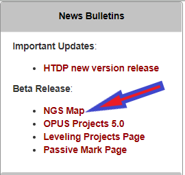
On Nov. 9, the National Geodetic Survey (NGS) announced the release of a new Beta NGS Map. This web application allows users to view multiple datasets that are useful to anyone planning or performing a survey project, or anyone that’s just looking for NGS marks.
The map enables users to access NGS datasheets, OPUS Shared Solutions, and the NOAA CORS Network. It also provides a measuring tool, multiple basemaps, and the ability to export data.
I recently used this tool on my iPhone to locate marks when I was traveling. It’s an amazing tool that is easy to navigate, and a useful tool for identifying marks to be included in a project.
The NGS homepage provides a link to the Beta NGS Map (see below).
Image: NGS Website
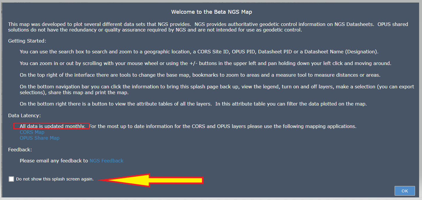
When you first click on the NGS Map link a short narrative appears that provides a brief set of instructions on how to use the map (see below). There’s a box that you can check so that the narrative will not appear every time you access the site. It’s important to note that the data for the CORS and OPUS Shared results are updated monthly. This could be an issue in some instances, therefore users should always check the NGS website for the latest information for the NOAA CORS Network or OPUS Shared map.
Beta NGS Map. (Image: NGS website)
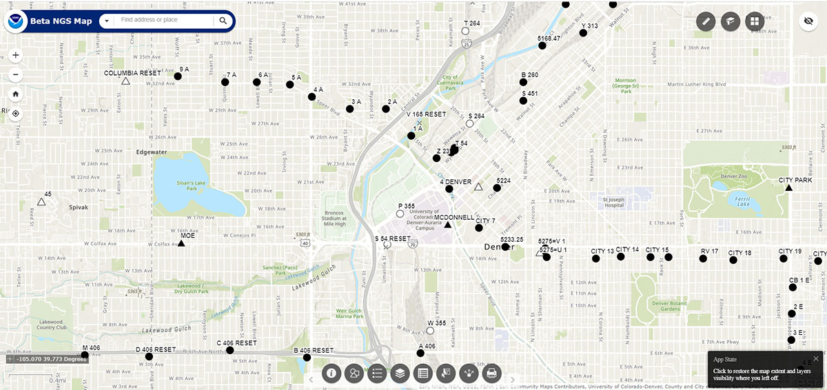
After you click OK at the bottom right of the page, a sample map will appear.
Sample map of Denver region. (Image: NGS website)
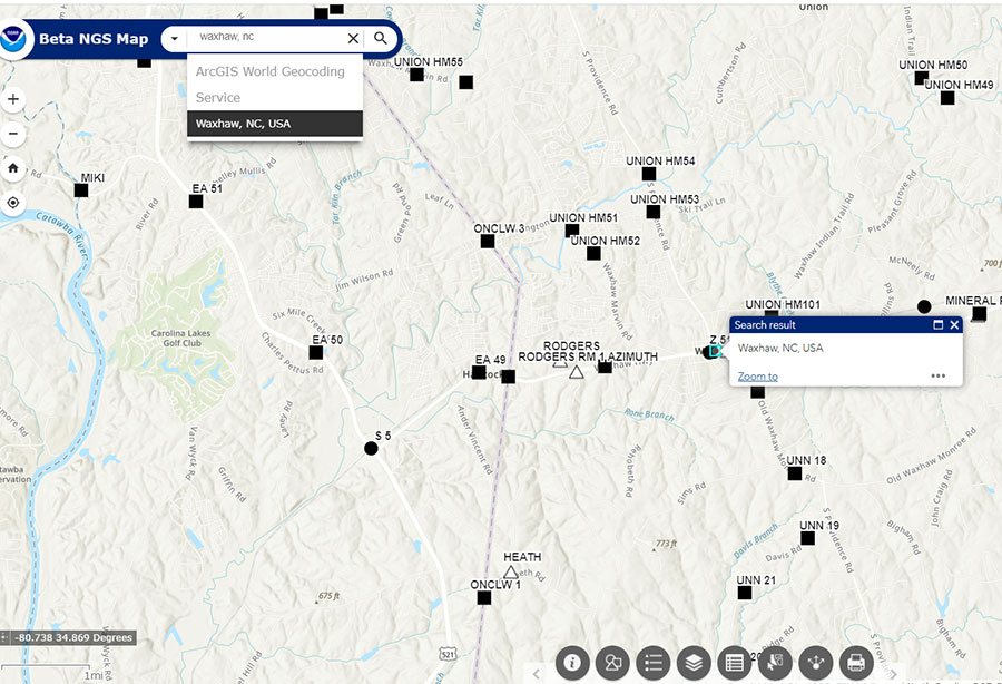
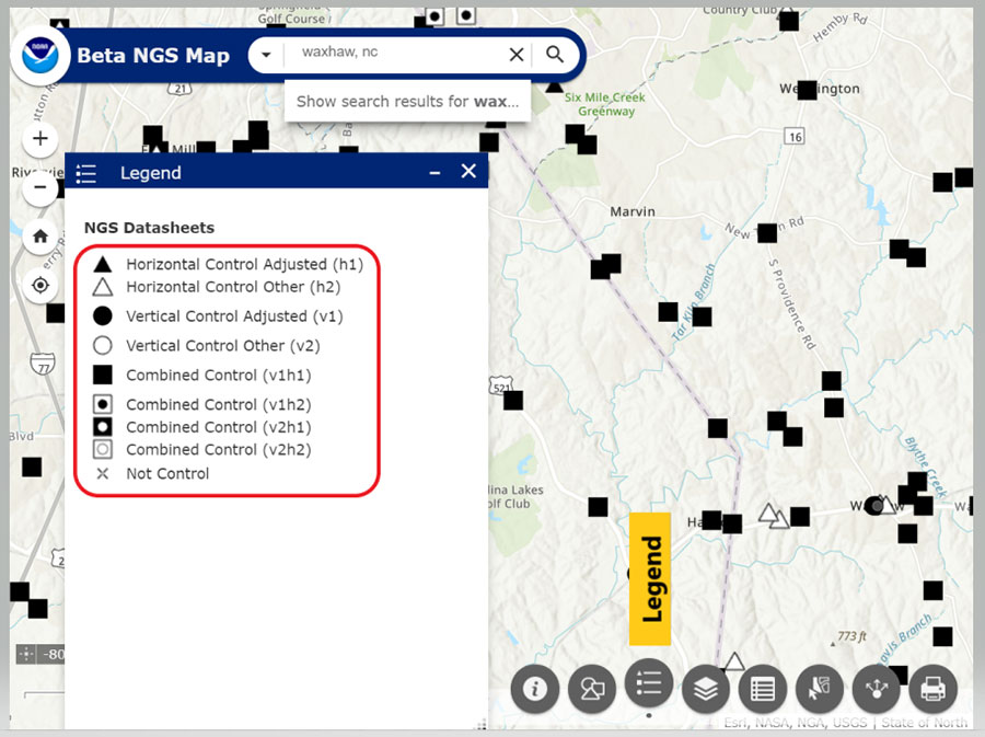
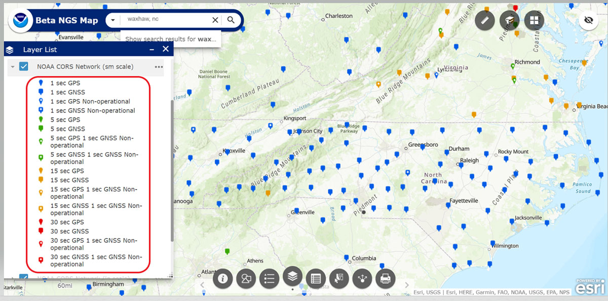
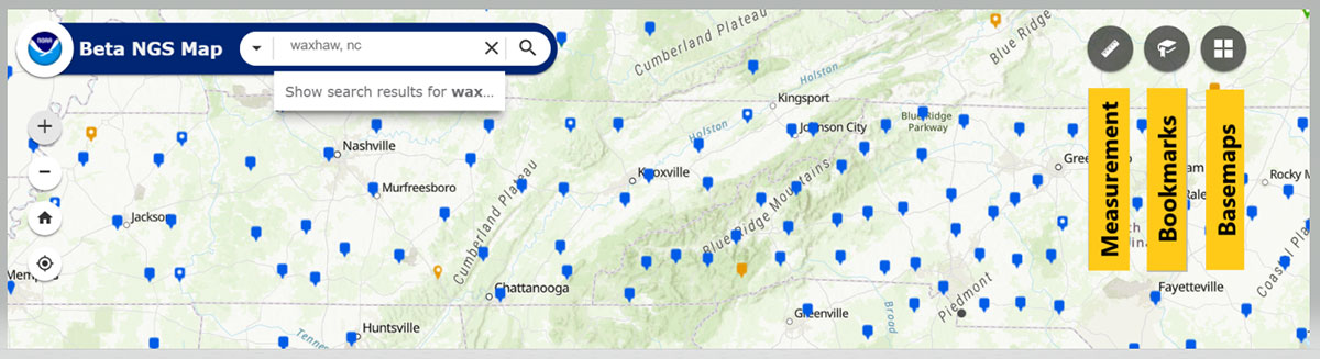
The map allows the user to type in a location (geographic location, CORS Site ID, OPUS PID, Datasheet PID or Datasheet Name) to start a search. See the “Waxhaw, North Carolina, Region” map as an example of entering a geographic location.
Waxhaw, North Carolina, Region. (Image: NGS Website)
The bottom navigation bar has eight buttons.
List of buttons at the bottom of the map. (Image: Dave Zilkoski)
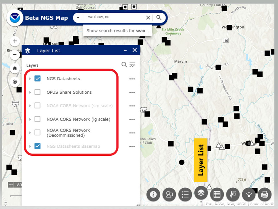
When clicked, a window pops up providing information about that particular button. (For example, see “Map with Legend Information” below.) The legend will include all layers that have been selected. In my example, the datasheet layer was the only layer I had selected (see “Map with Layer Information”.)
Map with legend information. (Image: NGS Website highlighted by Dave Zilkoski)Map with layer information. (Image: NGS website highlighted by Dave Zilkoski)
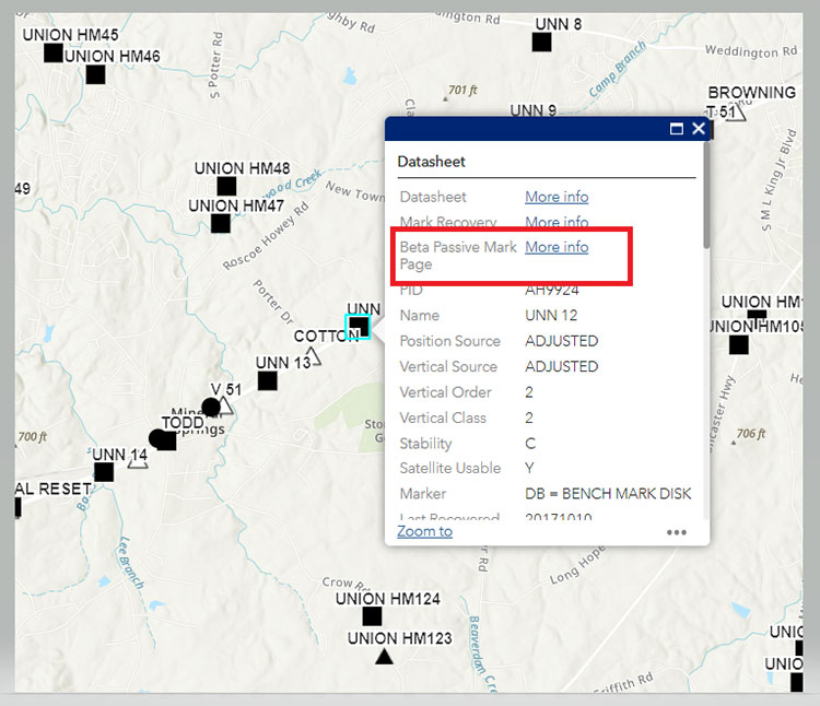
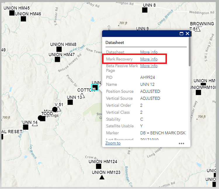
When the user clicks on a symbol, a box will appear with information about the mark. See “Information for Station UNN 12” below.
Information for Station UNN 12. (Image: NGS Website)
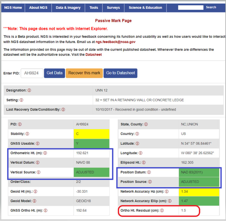
The box contains information from the NGS datasheet as well as a link to the actual NGS database. A nice feature of this webtool is that it provides a link to NGS’s Beta Passive Mark webtool. My October 2020 Survey Scene column highlighted the features of the NGS’s Passive Mark tool. The box captioned “Passive Mark Page for Station UNN 12” is an example of the tool. I’ve highlighted several items important to individuals planning surveys, such as the mark’s coordinates, datums and source, and the Orthometric Height residual (the difference between the estimated geoid height and the modeled hybrid geoid height).
Passive Mark Page for Station UNN 12. (Image: NGS website)
Another great feature is that the user can click on the Mark Recovery link to provide the latest recovery information for a mark (see the box titled “Mark Recovery Link for Station UNN 12 “).
Mark Recovery Link for Station UNN 12. (Image: NGS website)
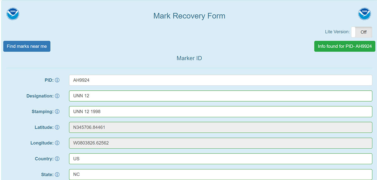
When a user clicks on the More info link for the Recovery Mark option, a Mark Recovery Form is provided for the user to enter the recovery information for the mark. The routine fills in the fields based on the current data in NGS’s database (see the box titled “Mark Recovery Form for Station UNN 12”). The user can enter changes or new information about the mark. This information is very important to users planning surveys. Just because a mark has been occupied by GNSS in the past doesn’t mean that it’s still a good station for occupation by GNSS. The environmental conditions around the mark could have changed since the last time it was occupied; for example, new buildings and/or growth of trees may now obstruct the GNSS signals.
As previously stated, the NOAA CORS Network is one of the layers available. The box titled “Map of NOAA CORS Network in the North Carolina Region” depicts the locations of the NOAA CORS in North Carolina. The layer list provides some of the attributes of the CORS, such as the sampling rate and which GNSS signal are collected at the site.
Map of NOAA CORS Network in the North Carolina Region. (Image: NGS website)
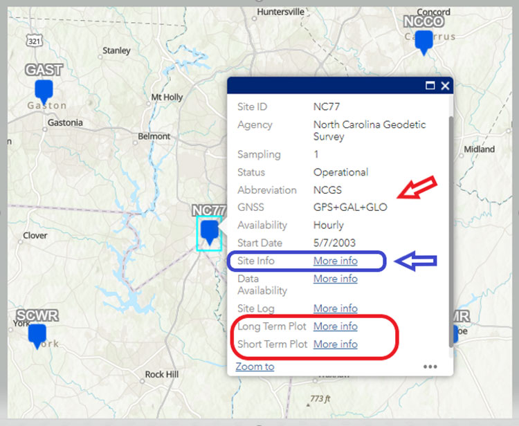
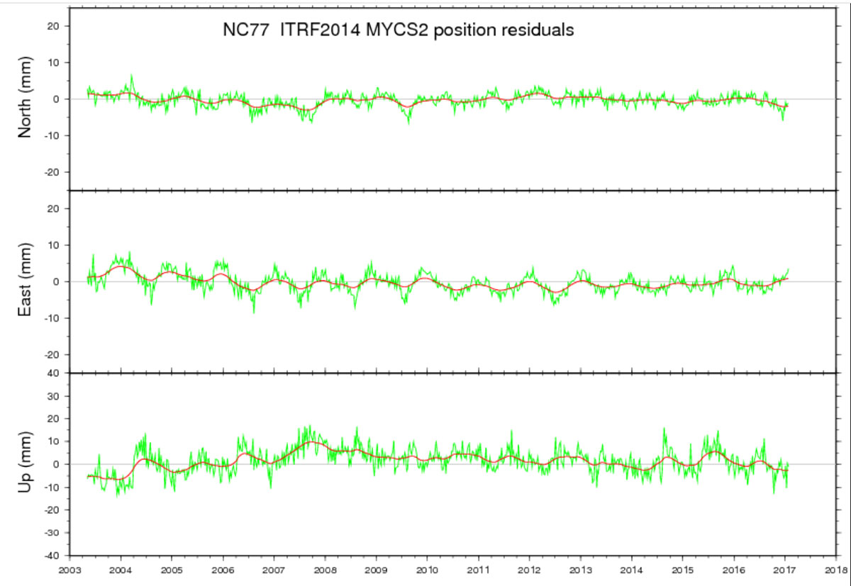
When a user clicks on a specific CORS, a box appears with information for that particular CORS. I’ve highlighted several items in the box titled “Information on CORS Site ID NC77.” In my example, CORS NC77 collects GPS, Galileo,and GLONASS data. Also, users can obtain long-term and short-term plots of the CORS.
Once again, this feature is important to users planning and performing GNSS survey projects. As in the other features, clicking on the More Info link will bring up the plots. The plots for CORS NC77 are provided in the boxes titled “Long-Term Plot Information on CORS Site ID NC77” and “Short-Term Plot Information on CORS Site ID NC77” below.
Information on CORS Site ID NC77. (Image: NGS website)Long-Term Plot Information on CORS Site ID NC77. (Image: NGS website)
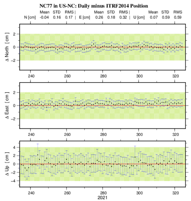
In the short-term plot, the red line is the published position, and the green hashed area is the tolerance of the NGS position, that is +/- 2 cm horizontal and +/–4 cm vertical. All the error bars are 1 sigma values. This information is useful when selecting NOAA CORS to be included in a survey project.
The short-term plot contains the mean, standard deviation and RMS values for the north, east and up components of the site. When planning a GNSS project, users typically identify several NOAA CORS to be included in the project. However, not all CORS are equal.
I evaluate CORS using the following criteria:
Designated as “operational”
Computed (i.e., measured) velocities rather than modeled (i.e., predicted) velocities.
“Consistent” data depicted in short-term time-series plots.
Network accuracies ~1 to 1.5 cm horizontally and less than ~2 to 3 cm in ellipsoid height.
Clicking on the More Info button for Site Info of NC77 provides a webpage where most of this information can be obtained.
Before conducting any post-processing, the analyst should ensure that all CORS included in the project have data for all of the occupations and that the station’s short-term plots indicate stability.
Short-Term Plot Information on CORS Site ID NC77. (Image: NGS website)
Tool buttons are situated in the top right section of the map. Included are a measurement tool to measure distances between marks and areas, a bookmarks tool to zoom to areas, and a basemaps tool to change the basemap. See the box titled “Useful Tools.”
Useful tools. (Image: NGS website)
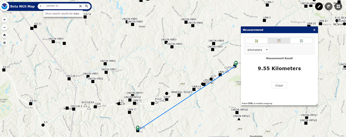
Some users may find the measurement tool helpful when planning a survey. The box titled “Using the Measurement Tool” is an example of measuring the distance between two stations.
Using the measurement tool. (Image: NGS website)
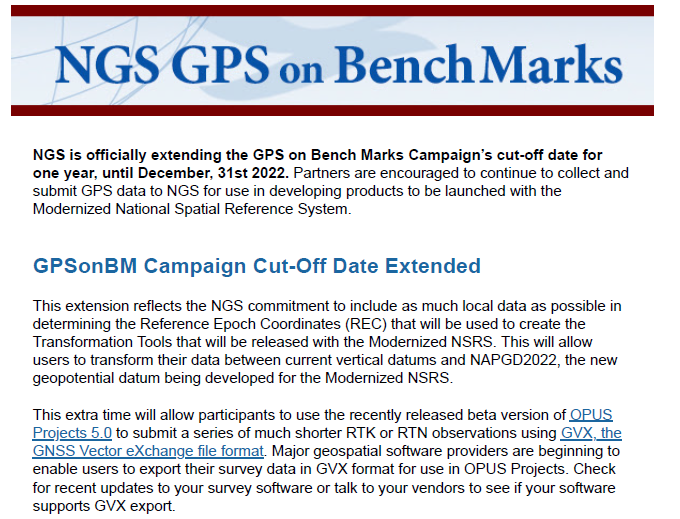
The last item that I’d like to highlight is that on Nov. 18, NGS has officially extended the GPS on Bench Marks campaign’s cut-off date for one year until December 31, 2022. See the box titled “NGS GPS on Bench Marks Notice.”
NGS GPS on Bench Marks Notice. (Image: NGS website)
NGS is anticipating that this extra time will allow users to provide additional GPS on Bench Marks data using the recently released beta version of OPUS Projects 5.0.
As stated in the NGS news release, this extension reflects NGS’ commitment to include as much data as possible in determining the Reference Epoch Coordinates (REC) that will be used to create the Transformation Tools to be released with the Modernized NSRS.
I encourage everyone to try the new Beta NGS Map. As in all of NGS beta products, NGS would like users to try the tools and provide feedback on what they liked and what they didn’t like. They are trying to develop tools useful to everyone, but that won’t be possible unless they hear from users.