GNSS correction service receivers and the firmware-upgraded ZED-F9P upgraded to achieve reliable centimeter-level accuracies in seconds
Photo: U-blox
U‑blox is offering a suite of products and feature additions that simplify access to reliable centimeter-level positioning accuracies for the industrial, navigation and robotics markets.
The upgraded ZED-F9P high-precision GNSS receiver module and the corresponding NEO-D9S and NEO-D9C GNSS correction data receivers offer customers flexibility in assembling scalable solutions for their specific use cases, including robotic lawnmowers, unmanned autonomous vehicles (UAV) and semi-automated or fully automated machinery.
The software-upgraded u‑blox ZED-F9P-04B high-precision GNSS receiver is the first to support a secure SPARTN GNSS correction data format. It seamlessly connects to two new GNSS correction service receiver modules that stream correction data from communication satellites:
The u‑blox NEO-D9S will initially cover the European and U.S. markets before rolling out to the other areas of the globe.
The u‑blox NEO-D9C will cover Japan.
The NEO-D9S receives correction data using the SSR SPARTN data format over the satellite L-band channel. It uses cryptography to securely deliver PPP-RTK GNSS correction data, such as that offered by u‑blox’s PointPerfect service.
The NEO-D9C leverages the subscription-free Centimeter-Level Augmentation Service (CLAS) broadcast over mainland Japan provided by the Japanese Quasi-Zenith Satellite System (QZSS) constellation on the L6-band channel.
While u‑blox GNSS receivers are designed to work with most correction services on the market, pairing the ZED-F9P with the NEO-D9C or the NEO-D9S correction data receiver enables customers to save data transmission cost and operational efforts, the company said.
ZED-F9P-04B offers a new feature called protection level, which increases the trust applications can place in its position output. By continuously outputting the upper bound of the maximum likely positioning error, referred to as the protection level, the receiver lets autonomous applications, such as UAVs, make efficient real time path planning, increasing the quality of their operations.
In the case of robotic lawnmowers, the increased accuracy and reliability of the position will, for example, make it possible to do away with boundary wires, which today are buried under the turf to delimit the mowing area. Furthermore, it will allow lawnmowers to systematically cover a plot based on a digital map, as opposed to the random mowing approach commonly used today.
First samples of these products are available today, in professional and automotive grade. The correction data receivers will be available in automotive grade for the automotive markets.
Harxon has introduced the HX-CUX005A to its family of helix antennas.
The HX-CUX005A is an embedded helix antenna designed for high-precision positioning. It offers superior satellite signal tracking, including GPS, GLONASS, Galileo and BeiDou as well as L-band correction service.
Upgraded with Wi-Fi and Bluetooth tunable (BT) for better integration, the HX-CUX005A is designed to be an all-in-one solution for surveying, unmanned aerial vehicles (UAVs), personnel and vehicle monitoring, and many more applications.
The powerful antenna has Harxon’s patented D-QHA technology and multi-point feeding technology. It is able to provide reliable and consistent signal tracking with centimeter-level accuracy by exhibiting a stable phase center, 2.5-dBi high gain with ultra-low signal loss, wide beam width and exceptional low-elevation satellite tracking.
In addition, the HX-CUX005A is optimized in circuit layout and equipped with robust pre-filtered low noise amplifier that guarantees excellent out-of-band rejection performance and strong multipath reduction capacity. In this way, unwanted electromagnetic interference is restrained for improved signal filtering over all GNSS frequency bands.
The integration of Wi-Fi and Bluetooth (2.4 GHz/5.8 GHz) provides 1-dBi gain (typical value) to enable easy connection and configuration for mobile device users. Its highly integrated design simplifies development process and reduces costs for device engineers, Harxon said.
Key Features of the HX-CUX005A
Comprehensive GNSS support: GPS, GLONASS, Galileo, BeiDou and L-band correction service
Centimeter phase-center repeatability, high gain at low elevation
Improved signal filtering and excellent multipath rejection
Weighs 10 grams in small form factor to facilitate integration
Integrated with Wi-Fi and Bluetooth tunable (2.4 GHz/5.8 GHz).
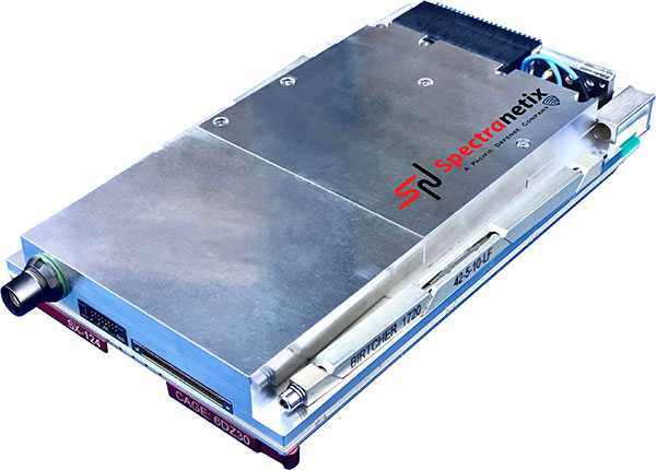
Spectranetix Inc., a Pacific Defense company, has announced the SX-124 ruggedized 3U OpenVPX high-performance positioning, navigation and timing (PNT) card.
With an ability to provide timing and positioning information in a GPS-denied environment through sensor fusion, the SX‑124 switch is designed for highly integrated systems with a requirement for the U.S. Army’s C5ISR Modular Open Suite of Standards (CMOSS) and alignment with the Open Group Sensor Open Systems Architecture (SOSA) technical standard.
The SX-124 can accept external sources or use its onboard GNSS receivers as reference inputs for timing and positioning data. The positioning data can be fused with internal and external inertial measurement units (IMUs). It distributes 11 100-MHz outputs and 11 1PPS outputs in a phase coherent manner.
The SX-124 provides timing and position holdover from an internal chip-scale atomic clock (CSAC) and IMU. A built-in time-of-day clock provides accurate network time stamps on system startup without GPS availability.
The SX-124 also provides enhanced location information and can be connected to an external IMU as well as a controlled reception pattern antenna (CPRA).
The SX-124 supports the standard VICTORY shared PNT services from a built-in GNSS timing receiver with an optional built-in M-code GB-GRAM receiver, CSAC and barometer to provide altitude information.
With the option for expansion to support over-the-air rekeying (OTAR), external fiber-optic gyroscope (FOG), alternative navigation (ALTNAV), and additional GNSS systems such as Galileo, the SX-124 supports the defense community’s need for a high-performance assured PNT (A-PNT) solution in the 3U VPX form factor and aligned to the latest open set of standards.
“Reliable situational awareness and cooperative, networked maneuvers demand assured PNT capability,” said Daniel Kilfoyle, CTO of Pacific Defense. “Our A-PNT solution embraces the pntOS open sensor-fusion framework and supports multiple sensor connections including GNSS receiver, GB-GRAM, IMU, FOG, CRPA and a two-channel software-defined RF receiver for added flexibility. Combined with exquisite timing and frequency performance and CMOSS alignment, this PNT card is yet another example of our commitment to CMOSS and SOSA.”
The SX-124 card is on track for production release early next year.
“The tasks of paleontologists and classical historians and archaeologists are remarkably similar — to excavate, decipher and bring to life the tantalizing remnants of a time we will never see.” — Adrienne Mayor
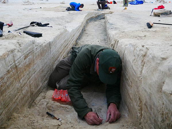
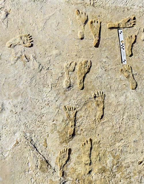
Heatwaves rose up from the dusty, dry, cracked ground. Tiny black flies buzzed around the team’s eyes and faces. The only shade was under a canopy erected across the shallow open trench where half a dozen people gently brushed away the layers. Dirt is time; the deeper one digs, the further back in time one goes.
A layer 23,000 years old is exposed at nearly two feet down, revealing footprints of a female and a toddler. It tells a story of her mile-long journey through the soft clay mud. Roaming nearby was a giant sloth and a herd of mammoths. This discovery forces science to re-adjust the timeline of humans living on the North American continent, pushing it further back into the Pleistocene era at least 10,000 years.
Discoveries like this are the treasures archeologists seek. Archaeologists are scientists — part treasure hunters and part storytellers. They add context to history.
A trench dug into the brown gypsum soil on a lake playa in White Sands National Park reveals more human footprints below the surface. (Photo: National Park Service)
Ground-Penetrating Radar
Advanced technologies are aiding new discoveries of the past. Even though the footprints were buried beneath two feet of dirt, they were discovered without physically seeing them. Ground-penetrating radar (GPR) made the discovery possible. GPR has made significant advancements in recent years, along with improvements in other types of remote sensing applications.
The resolution of GPR has improved along with the depths that GPR can detect objects. Computers can process the GPR data into 3D images providing a depth profile of the scanned area. This is how the footprints were detected.
White Sands has the largest collection of fossilized human footprints. (Photo: National Park Service)
In addition to GPR, the researchers used magnetometers that verify disturbances in the sediment, which can also be imaged in 3D, albeit with a much lower resolution.
“The sediment itself has a memory that records the effects of the animal’s weight and momentum in a beautiful way. It gives us a way to understand the biomechanics of extinct fauna that we never had before,” said Thomas Urban, the Cornell University research scientist who led the team making the discovery.
Usually, archeological findings are of bones and artifacts. Fossilized “ghost” footprints of humans and other creatures brings them to life, providing glimpses of the living past.
Under ideal conditions, GPR can reach depths of 30 meters (98 feet). The accuracy and range of GPR depend on sediment type, moisture content and other geologic morphologies. Underlying GPR technology and magnetometry are robust geospatial information systems (GIS) that preserve a digital record of the discovery, allowing for further geospatial analyses. Advances in machine learning will improve future detection.
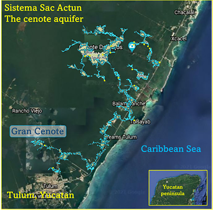
Elsewhere in the Americas, a project has been ongoing in Mexico since the 1990s using GPR to map the cenotes and underground aquifers used by the Mayans. A 215-mile-long underground water cave system — the longest in the world — has been mapped in the Yucatan peninsula. Divers exploring these cenotes found remains of Ice Age animals, including a sabertooth tigers and mammoths.
Map: William Tewelow
Lidar and ALS
Lidar (light detection and ranging) is making even more discoveries possible with the help of artificial intelligence and machine learning. For instance, in the jungles of Guatemala, lidar revealed the unknown ancient Mayan city of Tikal.
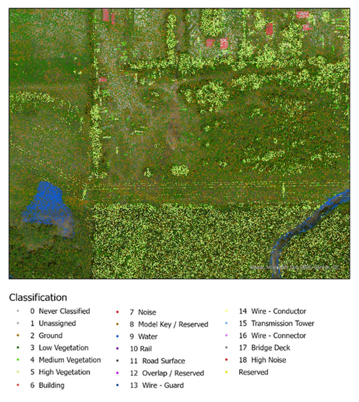
Lidar is an active sensor that measures ground height. Using an airborne laser scanning (ALS) system mounted to a plane, helicopter or UAV, the lidar device’s laser beams scan the landscape. The system calculates the time it takes for the beam to reach an object on the ground and bounce back.
The result generates one point for each ground object the laser touches, calculating the distance the beam traveled. Billions of points are collected during a scan. Geospatial archeologists then process the collected points into a point cloud (Figure 1). Selecting only points classified as ground and water, the points are converted to a raster image, and archeologists are provided a perspective of the bare earth under tree canopy and vegetation (Figure 2).
In this way, lidar serves as a non-destructive way to identify earthwork formations, even in dense jungle.
Figure 2. Lidar points are converted to a raster providing a bare-earth representation of the landscape. (Image: Stephanie Clark)
Figure 3. Pixel-derived object-based classification, developed using machine learning, identifies unmarked headstones from UAV-collected imagery. (Image: Stephanie Clark)
Object-Based Imagery Analysis
The challenge with lidar and imagery is the sheer volume of data, beyond the scope of what a human can manually review. Because of how faint archaeological features can be, the search often requires manipulating imagery datasets by combining multispectral bands, and then merging them with topographical data. To assist this huge endeavor, artificial intelligence is applied to pixel-based classification and object-based imagery analysis (OBIA) to highlight areas of interest for further study.
Dylan Davis, a Ph.D. candidate at Pennsylvania State University, spearheaded the use of OBIA for finding earthworks such as circular mounds, stone walls,and roadways in Beaufort, South Carolina. He took advantage of high-resolution NOAA imagery taken of the coast before the hurricane season of 2008. Using artificial intelligence for object-based imagery analysis, 160 previously undetected mound features were found.
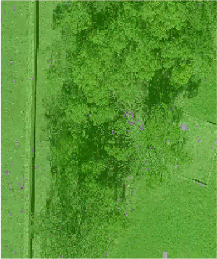
Raster comparison: Sea Pines Shell Ring, Hilton Head Island, South Carolina. Credit: Dylan S. Davis, Matthew C. Sanger & Carl P. Lipo (2018): “Automated mound detection using lidar and object-based image analysis in Beaufort County, South Carolina,” Southeastern Archaeology [https://doi.org/10.1080/0734578X.2018.1482186]On the local level, archeologists apply the same approach to finding headstones in unmarked cemeteries. A pixel-defined object-based classification system helped one researcher automatically identify potential headstones in a densely vegetated cemetery.
The technology used for OBIA is also used for visual-inertial odometry (VIO). NASA is experimenting with VIO techniques to help astronauts navigate the lunar surface (see NASA’s Artemis program will need lunar spatial reference system). For Artemis, VIO will use the Moon’s craters as a reference system to derive an accurate position.
Virtual 3D Worlds
Perhaps one of the most significant uses of technology for archaeological research and exploration is the use of virtual 3D immersive worlds. Exploring ancient worlds as they might have looked gives archaeologists additional insights and the public a chance to experience their discoveries, connecting us with history.
The mile-long journey of a young female carrying a toddler across an Ice Age landscape 23,000 years ago seems so distant, yet so familiar to any parent. The image breathes life into our common ancestry. Through the power of GIS and modern technologies, she walked right into the 21st century.
“The man who knows and dwells in history adds a new dimension to his existence…He lives in all time; the ages are his, all live alike to him.” — William Flinders Petrie
Special thanks to Stephanie Clark, a geospatial archeologist with Integrated Environmental Solutions, LLC, of Phenix City, Alabama. Stephanie provided technical advice and collaboration, and the lidar studies for Figures 1, 2 and 3.
William Tewelow is a senior aeronautical information specialist for the Federal Aviation Administration. He is a 2016 graduate of the FAA’s management fellowship Program for Emerging Leaders and a mentor with the FAA’s National Mentor Program. He served on special assignment to the U.S. Department of Transportation and led a national strategic geospatial initiative under the authority of the White House Open Data Partnership.
Tewelow is a designated Geographic Information Systems Professionals (GISP), with degrees in geographic information technology and Intelligence Studies. he is currently earning his master’s degree in organizational leadership with a focus on performance management.
Tewelow retired from the U.S. Navy after serving 23 years as a geospatial and imagery intelligence specialist, a naval aviator, a meteorologist and a tactical oceanographer earning three achievement medals. He was among the first in the nation to earn a Geospatial Specialist Certification from the U.S. Department of Labor while working at NASA Stennis Space Center. He is married, enjoys traveling, connecting people, and solving problems, and is interested in new technology. His favorite quote is, “A man’s mind changed by a new idea can never go back to its original dimension.” ~ Oliver Wendell Holmes
AnimaMundi is a not-for-profit organization based in Geneva, Switzerland. Its proprietary technology interprets photo and video records to extract a single-use plastic bottle count. The information can be captured via an app using still photography as well as images from drones. The data is automatically uploaded, processed and stored on the company’s servers. The data will enable decisions to facilitate environmental investments and measure the impact of waste-management initiatives.
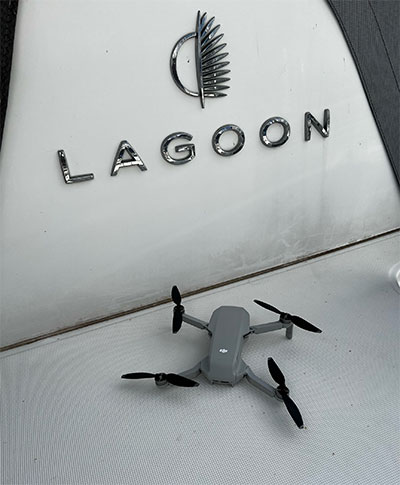
The process begins with DJI drones piloted by sailors taking place in the Atlantic Rally for Cruisers (ARC), which started from Las Palmas in the Canary Islands, on Nov. 21. DJI provided drones to Lagoon, a sailing catamaran cruiser maker, to measure plastic waste on beaches around the Caribbean.
Of the more than 300 million tons of plastic produced every year, at least 8 million tons end up in the ocean, making up 80% of all marine debris, from surface waters to deep-sea sediment. About 33,000 single-use plastic bottles are dumped in the ocean every minute of every day, affecting every coastline.
Matt Cooper, founder and CEO, AnimaMundi is driven by the need for accurate real time data to ensure investment decisions are made correctly with measurable impact. “Just before COP26 began, world leaders admitted that an annual $100-billion climate finance goal will not be reached until 2023,” Cooper said. “The need for urgent climate action is met with the need to ensure adequate and effective financing solutions. Big data like this will help to determine priorities for action.”
Lagoon has been a partner of the ARC rally since 2005. Through its Club Lagoon, the company encourages its owners to sign up to this program aiming at reducing plastic waste in our oceans thanks to data collected by drones.
“Lagoon is proud to be partnering with AnimaMundi in this exciting data collection initiative using our ‘Club Lagoon’ as part of the solution,” said Thomas Gailly, Lagoon brand director. “We have more than 6,000 of our catamarans sailing around the world, and we can feel that our customers are more and more willing to play a role in such initiatives. It’s stimulating to think that the Lagoon owners’ community could be involved in capturing this much needed data in a highly efficient way. This partnership is the perfect complement to our own policy of respect for the environment and all the work undertaken to reduce the environmental impact of our activities.”
DJI, the global leader in developing and manufacturing civilian drones and aerial imaging technology for personal and professional use, has provided repurposed drones to capture images of the Caribbean coastline that would otherwise be out of reach. “Our drones and cameras empower people to capture amazing photos, video, and high-end professional imagery in every corner of the world,” said Olivier Mondon, senior communication manager at DJI Europe. “Each day, we learn how drones benefit society as a whole, and we are proud to have our drones embark on this environmental journey with experienced sailors who will be able to work using repurposed products to enable invaluable data capture.”
Initially targeting the Caribbean islands, AnimaMundi is also finalizing a partnership with the International Union for Conservation of Nature (IUCN) and its Plastic Waste-Free Islands (PWFI) initiative to generate weekly total island coastal plastic waste profiles covering Grenada, St. Lucia, Antigua and Barbuda.
In 2019, with the support of the Norwegian Agency for Development Cooperation, IUCN launched the PWFI project in the Caribbean, the Mediterranean and Oceania, seeking to promote a circular economy and demonstrate effective, quantifiable solutions to address plastic leakage from small island developing states.
Integrated solution combines and consolidates valuable telematics data for Geotab and GM customers in Canada
Geotab Inc. has announced the availability of the Geotab Integrated Solution for General Motors in Canada. With no additional hardware installation required, the offering provides Canadian customers with a simplified fleet management platform to help businesses make better informed decisions.
With this integration, data from compatible GM vehicles, 2016 or newer, with OnStar embedded factory-first hardware can be securely transferred into Geotab’s web-based fleet management software, integrating all vehicle data into one platform, offering businesses and fleets a seamless user experience.
By enabling fleet managers to access rich proprietary vehicle data, they can generate safety reports, activity reports and measure other key metrics on one platform to help optimize fleet performance.
Users can expand the functionality of the solution further with access to the Geotab Marketplace, a growing portfolio of mobile apps and software and hardware add-ons to enable customers to tailor their fleet management solution to help meet all of their connectivity needs including improved safety, productivity and efficiency.
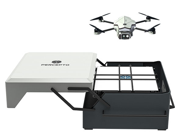
Percepto Air Mobile drone with base. (Photo: Percepto)
Percepto, an Israel-based company specializing in autonomous inspection with industrial robotics, has launched its 2022 Autonomous Inspection & Monitoring (AIM) platform and Air Mobile drone.
Recently listed in TIME magazine’s 100 Best Inventions of 2021, Percepto offers an end-to-end solution powered by artificial intelligence (AI) to collate and streamline all visual data for accurate actionable insights.
Percepto AIM 2022 has a new Insight Manager to deliver AI-powered packaged solutions for sector-specific use cases, such as solar, mining, energy, oil and gas and other industries. The company drew on tens of thousands of hours collected by autonomous robot missions at industrial facilities to create it.
Percepto’s AI change-detection framework offers unified visual data and critical business insights for each of the sector-specific solutions. AIM 2022 can be integrated with autonomous drones and robots as well as other visual data collectors, now including DJI drones, and fixed cameras.
Reports and insights are automatically generated based on the combined visual data. Disseminated to relevant stakeholders on any mobile device, issues and faults are geotagged and displayed on a map, enabling effective action before escalating into more serious problems.
Percepto also introduced its new Percepto Air portfolio to support the enhanced platform, which will address the diverse needs and increasing demands of various markets.
Percepto Air Max. The next generation of Percepto Sparrow, the Percepto Air Max is a field-proven solution that operates in the largest mining, oil and gas, and energy companies on six continents. It has a top-grade, versatile payload for specific use cases. Designed to inspect and map complex industrial environments where the highest accuracy and durability are critical, Air Max also has an optical gas imaging (OGI) camera.
Percepto Air Mobile. This option is a more compact and lighter weight model for smaller sites or organizations taking their first steps with a drone-in-the-box program, or larger sites that need greater deployment flexibility. It is designed for linear inspections, such as pipelines and power lines, and can monitor short-term projects across multiple sites, such as construction sites.
Percepto Air Max and Air Mobile drones are stored permanently onsite within their respective Percepto Bases. The Air Mobile’s base is light and easy to relocate while maintaining high levels of durability. These encasements are designed for infrequent maintenance and protection against extreme environmental phenomena, such as hurricanes. Percepto’s drones are safe and regulation ready, and ensure all operational aspects meet corporate standards.
“Percepto AIM 2022 and the new Percepto Air line of drones, together with the most advanced change detection solution, alert and prevent failures and downtime within diverse use cases across many industries,” said Percepto CEO Dor Abuhasira. “Percepto AIM provides the most advanced and comprehensive enterprise inspection software that offers a complete data workflow — from capture to insight. With Percepto Air Max and Percepto Air Mobile, companies have a range of options to choose from depending on the size of their facilities and the flexibility needed to deploy drones.”
“The real power of Percepto’s system is how data collection and analytics are integrated for a holistic view from both a technical and management perspective,” said Tim Shanfelt, director of Operations Transformation, Koch Ag & Energy. “Our workers are connected to high-level information that helps them make the right decisions while keeping them safe and free to pursue higher value activities. Our goal is to eliminate hazardous, wasteful, and mundane tasks from our operators’ day. For example, instead of an employee climbing an icy ladder in the winter, a robot or drone can perform the same task while still obtaining accurate measurements. We see Percepto playing a significant role in helping make our facilities more safe, secure, efficient, and profitable.”
When I saw that there was a plan for a whole bunch of unmanned, semi-autonomous racecars to compete at the Indianapolis Motor Speedway (Indy, or IMS) racetrack, I initially thought we might be headed to one significant mess of broken-up machines and potentially a lot of damage. I tracked the various announcements of the competition as things progressed, especially when a prize of $1 million dollars was put up by the Lilly Endowment in Indianapolis, and the majority of the field appeared to be potentially staffed by undergrad university teams.
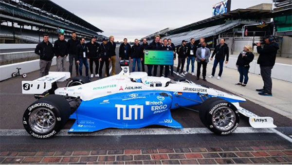
Photo: Indy Autonomous Challenge
However, this isn’t the first time we’ve had unmanned, autonomous road vehicles in competition — we’ve seen highly instrumented SUVs in desert settings in Nevada and California, initially with pretty poor results, which began to improve significantly for the second time round, then vehicles in some simulated street settings with some mixed and also some pretty good results.
So, as the competition date grew closer for the Indy Autonomous Challenge (IAC), the number of published progress reports began to increase, and we began to better understand how the initial 40 teams might take on this seemingly impossible task — how on Earth will they replicate a regular Indy (also a class of racecar) race? Surely many unmanned racecars on the same track at the same time doing more than 150 mph would be catastrophic!
When you take a look, however, at the advances we’ve seen, which have enabled unmanned cars, trucks, taxis and such – surely this tech could stretch to meet these major objectives? But Dallara AV-21 Indy Light racecars avoiding hurtling walls passing by, cornering, getting in and out of the pits, coping with vehicles behind, ahead and overtaking — even a superior-equipped unmanned racecar at >150 mph — well that’s something we would really need to see.
Then you have to take a look at the outfits involved, providing support to the IAC teams – companies including Cisco, and motor sport units such as ADLINK, Ansys, Aptiv, Bridgestone, Luminar, Microsoft and Valvoline and the non-profit Energy Systems Network. The University teams from around the world themselves appeared to also have significant heritage and skill-levels.
As the 40 University teams started the long trek to get over the hurdles that this challenge presented, members from 21 of those institutions were actually able to make it to Indy, grouped into nine “national” teams. By October 23 the nine teams, with only one car each, were ready to test their autonomous vehicles on the actual track.
Clemson University established the baseline Dallara AV-21 vehicle and technology to be used by each team for the race, with sensors monitoring chassis motion, suspension, tires and powertrain. Each team would install its own guidance and avoidance system, with each vehicle equipped with six cameras, four lidars, RTK GNSS, associated radios and bags of computing running each team’s customized control system software. The object being for cars to exit pit-lane, accelerate, brake, establish an optimum line for each corner and flat, avoid obstacles, evaluate the track conditions and establish tolerable limits.
The teams were required to complete several stages of selection, from submission of initial proposals through demonstration of existing vehicle automation capability, simulated race performance, qualification testing at the Indy track — all leading to an anticipated head-to head race against the other qualifiers.
Then 20 days of planned testing stretched to 50, and three months of preparation passed with students working intensely throughout, curing the glitches, experimenting with how to increase lap speed, and pushing the limits while still keeping the cars intact.
Energy Systems Network managed the rules of the final competition in a way that reflected Indy qualification days prior the main race — they judged that the technology was not yet at a stage where multiple cars on the track at the same time would have been such a good idea. So, each car was to individually run a number of practice/qualification laps and the quickest car would be the winner.
During the first stage of live competition, cars were required to exit the pits and run a warmup lap, followed by two laps that were timed and a slow-down lap that required navigating around inflatable barriers on the front-stretch, and then return successfully back around the track into their pit-stop locations. There were several spins in the corners and several crashes, but the four surviving cars/teams were able to optimistically post speeds of more than 130 mph.
Photo: Indy Autonomous Challenge
The final phase involved the four teams taking their cars around a number of warm-up/practice laps, followed by four timed laps. Only the car from Germany’s Technical University of Munich was able to complete all laps with an average speed of ~136 mph, so that team ultimately won the $1 million prize. Even so, all teams were able to successfully mature their systems’ performance through the many months leading up to the IAC and their progress through the various qualification stages. Even the other three final qualifiers had much to celebrate as a result of the competition.
The sponsors supporting the various teams as they progressed through the Challenge may have spent more than $120 million, so that high-pressure development work will be invested back into many vehicle automation opportunities. After all, that was the main objective for the whole undertaking. We should hopefully begin to see safer, more capable self-driving vehicles emerge in the months to come as the technology is applied to more production vehicle automation.
Analog Devices, Inc. (ADI) recently received four Electronics Industry 2021 Awards presented by Datateam Business Media. The awards honor the best professionals, products, projects, and companies across the electronics sector. ADI received awards in the following categories: environmental leadership, excellence in innovation (for the ADAR3000 beam forming integrated circuit), aerospace/military/defense product of the year, and embedded solution product of the year (for the MAX78000 artificial intelligence microcontroller). It also received the “Highly Commended” distinction in the Internet of Things product of the year category.
Established in 2018, the Electronics Industry Awards annually recognize the best people, products, and business practices at the forefront of innovation. The awards winners are determined by a 50/50 weighted decision from an industry vote and a panel of expert judges to ensure the winners are selected for technical expertise and outstanding reputations.
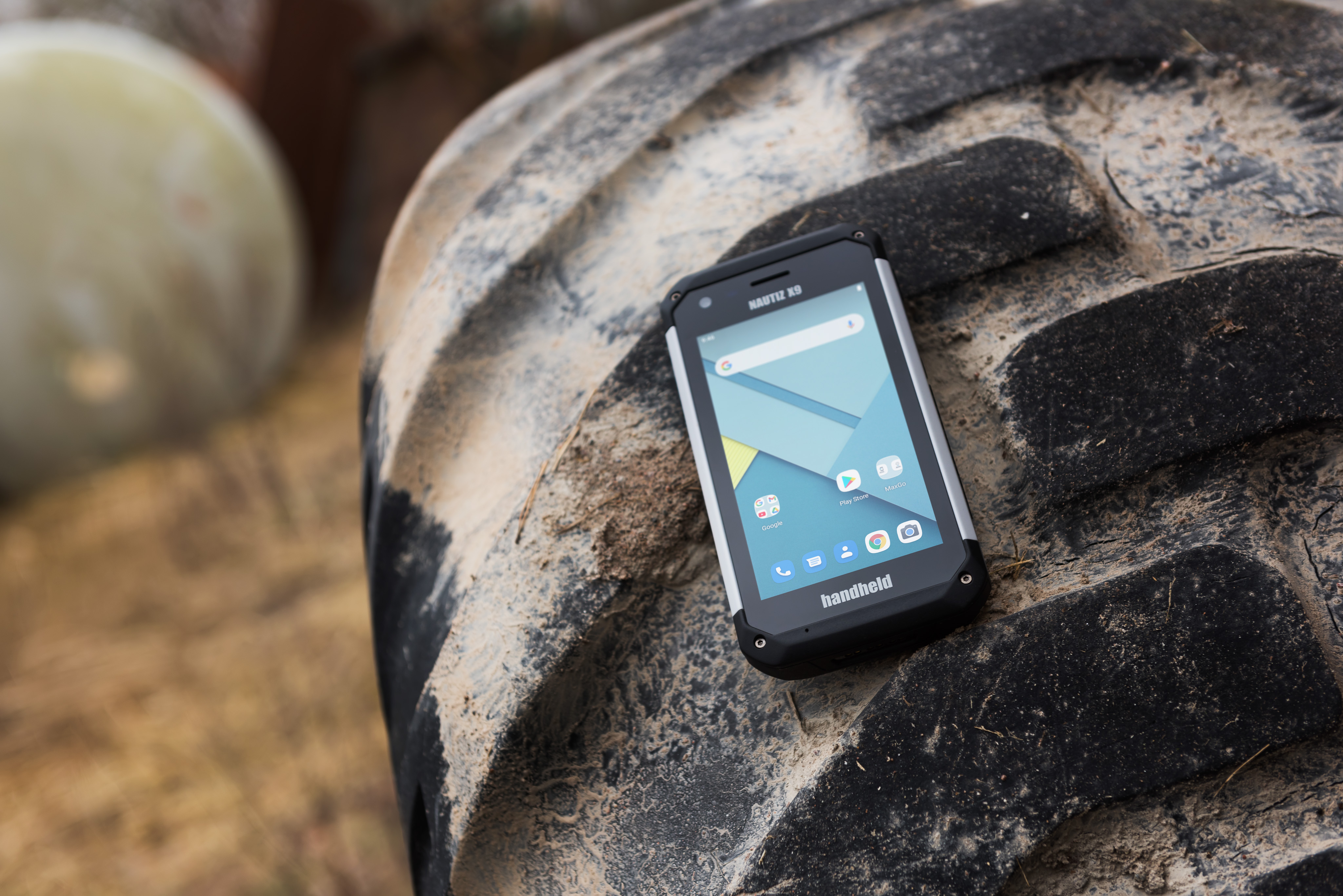
Handheld Group, a manufacturer of rugged mobile computers, has announced a new version of its NAUTIZ X9 PDA: an ultra-rugged enterprise handheld built for fieldwork in the most challenging outdoor and industrial environments.
With an upgraded platform, the Nautiz X9 Android rugged handheld runs Android 11 and is Android Enterprise Recommended (AER). The device, which has a sturdy magnesium casing, is targeted for mobile computing and data collection in industrial and field applications.
The Nautiz X9 ultra-rugged PDA offers:
MIL-STD 810G ruggedness for drops, vibrations, humidity, and broad operating temperature
IP67 rating for waterproof, dust-tight performance
a sunlight-readable 5-inch multi-touch display with glove and rain mode
a high speed 8-core MediaTek processor with 3 GB RAM and 32 GB storage
the Android 11 operating system with GMS
4G/LTE, dual band 802.11 a/b/g/n/ac wireless LAN, low-energy 5.0 BT and NFC
built-in GPS/GLONASS/Galileo capabilities as standard
dual cameras including 13-megapixel rear-facing, and 5-megapixel front-facing
optional high-quality, high-speed 2D imager
multiple enterprise-focused accessories
maxGo software to quickly apply custom settings to larger deployments
The new version of the Nautiz X9 is expected to start shipping this month.
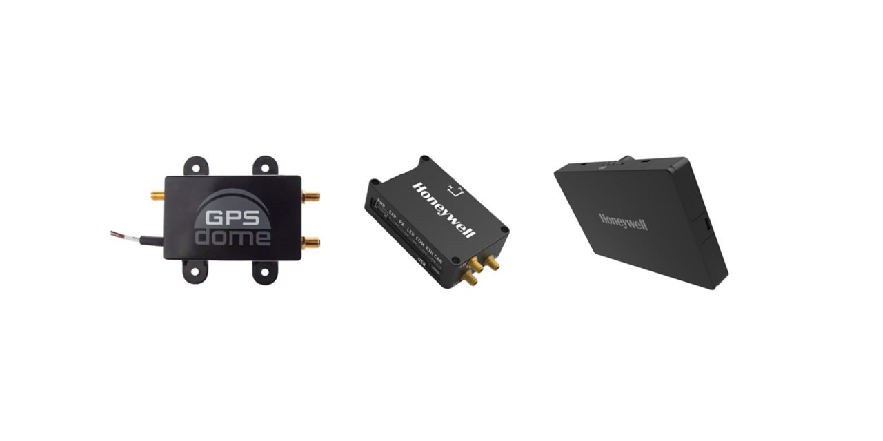
Honeywell has launched two new resilient navigation systems: the Honeywell Compact Inertial Navigation System and Honeywell Radar Velocity System. These systems, jointly with GPSdome, an anti-jamming system developed by Honeywell’s partner InfiniDome, are designed for commercial and military customers needing reliable navigation solutions that are small and light and have a low power consumption.
The systems will provide multiple layers of protection that allow continued operations even in GNSS-challenged or denied environments.
Honeywell’s philosophy of resilient navigation revolves around multiple layers of resiliency achieved by a combination of GNSS anti-jamming, inertial navigation and alternative navigation systems.
The GPSdome is a small add-on device that provides the first layer of protection against GNSS jamming attempts, ensuring continuity of operation during low-power jamming conditions and the ability to achieve the crucial first GPS lock even in GPS-challenged environments. The device is compatible with any off-the-shelf GNSS receiver and antenna. Honeywell signed a collaboration agreement with infiniDome in August to jointly develop and deliver GPS signal protection systems.
The new Honeywell Compact Inertial Navigation System is about the size of a deck of cards and uses tactical-grade inertial sensors to provide accurate position information to commercial and military customers. This second layer of resiliency provides the ability to navigate during shorter GNSS outages. This is especially useful in urban canyons where GNSS availability is intermittent or in strong jamming environments where anti-jamming systems are not enough.
The U.S. President’s National Space-based Positioning, Navigation and Timing (PNT) Advisory Board will meet on December 9 and 10 at the Sheraton Pentagon City Hotel in Arlington, VA, according to a post on the group’s website.
The meeting is open to the public. Interested parties are encouraged to attend.
The agenda, while still not finalized, is expected to include a full day public meeting on Thursday, December 9, and a half day on Friday, December 10.
Previous in-person meetings have included program updates from government departments and briefings on cutting edge government and industry projects on the first day. The second day normally sees updates from international representatives and open discussion of current issues among the board members.
The Advisory Board’s size is expected to increase at this meeting with three previous members leaving and nine newly appointed members being added.
A formal announcement of the meeting is expected in the Federal Register on Monday, November 15. Confirmation of the new membership roster is expected at about the same time.
The PNT Advisory Board was established in 2004 by National Presidential Security Directive 39, “U.S. Space-Based Positioning, Navigation, and Timing Policy.” It operates under the rules of the Federal Advisory Committee Act and is tasked with providing advice “… on U.S. PNT policy, planning, program management, and funding profiles in relation to the current state of national and international space-based PNT services.”
The Advisory Board has regularly advised the government on all aspects of space-based PNT, including the need for a holistic “PTA” approach – “Protect” signals, “Toughen” user equipment, and “Augment” services with alternative PNT sources.
This will be the first in-person meeting of the board since November 2019. A virtual meeting was held in July 2020.
After the conclusion of the government Advisory Board meeting on Friday, December 10, the non-profit Resilient Navigation and Timing Foundation will hold its annual membership meeting and lunch at the same venue.


![<b>Raster comparison: Sea Pines Shell Ring, Hilton Head Island, South Carolina. </b>Credit: Dylan S. Davis, Matthew C. Sanger & Carl P. Lipo (2018): Automated mound detection using lidar and object-based image analysis in Beaufort County, South Carolina, Southeastern Archaeology [https://doi.org/10.1080/0734578X.2018.1482186]](https://stage.globalpositioningnews.com/wp-content/uploads/2021/11/Davis-SC-mounds-HiltonHead.jpg)