Category: Applications

  • Sandia Labs shows GPS-free quantum-based wayfinding device

    Sandia Labs shows GPS-free quantum-based wayfinding device

    Sandia National Laboratories scientist Peter Schwindt, left, and postdoctoral scientist Bethany Little examine the vacuum package held in a yellow, 3D-printed mount. (Photo: Bret Latter/Sandia) 
    Sandia National Laboratories scientist Peter Schwindt, left, and postdoctoral scientist Bethany Little examine the vacuum package held in a yellow, 3D-printed mount. (Photo: Bret Latter/Sandia)

    The compact, fieldable device could provide means to navigating without GPS

    News from Sandia National Laboratory

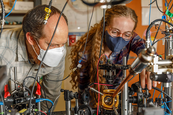
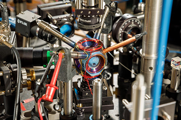
    Don’t let the titanium metal walls or the sapphire windows fool you. It’s what’s on the inside of this small, curious device that could someday kick off a new era of navigation.

    For more than a year, the avocado-sized vacuum chamber has contained a cloud of atoms at the right conditions for precise navigational measurements. It is the first device that is small, energy-efficient and reliable enough to potentially move quantum sensors — sensors that use quantum mechanics to outperform conventional technologies — from the lab into commercial use, said Sandia National Laboratories scientist Peter Schwindt.

    Sandia developed the chamber as a core technology for future navigation systems that don’t rely on GPS satellites, he said. It was described earlier this year in the journal AVS Quantum Science.

    Countless devices around the world use GPS for wayfinding. It’s possible because atomic clocks, which are known for extremely accurate timekeeping, hold the network of satellites perfectly in sync.

    But GPS signals can be jammed or spoofed, potentially disabling navigation systems on commercial and military vehicles alike, Schwindt said.

    Instead of relying on satellites, Schwindt said future vehicles might keep track of their own position. They could do that with onboard devices as accurate as atomic clocks, but that measure acceleration and rotation by shining lasers into small clouds of rubidium gas like the one Sandia has contained.

    Atomic accelerometers and gyroscopes already exist, but they’re too bulky and power-hungry to use in an airplane’s navigation system. That’s because they need a large vacuum system to work, one that needs thousands of volts of electricity.

    A compact device designed and built at Sandia National Laboratories could become a pivotal component of next-generation navigation systems. (Photo: Bret Latter/Sandia)
    A compact device designed and built at Sandia National Laboratories could become a pivotal component of next-generation navigation systems. (Photo: Bret Latter/Sandia)

    “Quantum sensors are a growing field, and there are lots of applications you can demonstrate in the lab,” said Sandia postdoctoral scientist Bethany Little, who is contributing to the research. “But when you move it into the real world, there are lots of problems you have to solve. Two are making the sensor compact and rugged. The physics takes place all in a cubic centimeter (0.06 cubic inches) of volume, so anything larger than that is wasted space.”

    Little said her team has shown that quantum sensing can work without a high-powered vacuum system. This shrinks the package to a practical size without sacrificing reliability.

    Instead of a powered vacuum pump, which whisks away molecules that leak in and wreck measurements, a pair of devices called getters use chemical reactions to bind intruders. The getters are each about the size of a pencil eraser so they can be tucked inside two narrow tubes sticking out of the titanium package. They also work without a power source.

    To further keep out contaminants, Schwindt partnered with Sandia materials scientists to build the chamber out of titanium and sapphire. These materials are especially good at blocking out gasses like helium, which can squeeze through stainless steel and Pyrex glass. Funding was provided by Sandia’s Laboratory Directed Research and Development program.

    Construction took sophisticated fabrication techniques that Sandia has honed to bond advanced materials for nuclear weapons components. And like a nuclear weapon, the titanium chamber must work reliably for years.

    The Sandia team is continuing to monitor the device. Their goal is to keep it sealed and operational for five years, an important milestone toward showing the technology is ready to be fielded. In the meantime, they’re exploring ways to streamline manufacturing.

    Sandia National Laboratories is a multimission laboratory operated by National Technology and Engineering Solutions of Sandia LLC, a wholly owned subsidiary of Honeywell International Inc., for the U.S. Department of Energy’s National Nuclear Security Administration. Sandia Labs has major research and development responsibilities in nuclear deterrence, global security, defense, energy technologies and economic competitiveness, with main facilities in Albuquerque, New Mexico, and Livermore, California.

  • Trimble and Microsoft partner on industry cloud for construction

    Trimble and Microsoft partner on industry cloud for construction

    Companies to develop an industry cloud to enable construction organizations to harness digital construction data across the project lifecycle

    Trimble and Microsoft have entered a strategic partnership to advance technology adoption and accelerate the digital transformation of the construction, agriculture and transportation industries.

    By leveraging the Microsoft cloud, Trimble and Microsoft will collaborate to develop, build and deliver industry cloud platforms and solutions that connect people, technology, tasks, data, processes and industry lifecycles. The collaboration represents a significant milestone to advance Trimble’s Connect and Scale 2025 strategy, which centers on building cloud platforms.

    Initially, Trimble and Microsoft will focus on building the Trimble Construction Cloud powered by Microsoft Azure.

    Image: Trimble
    Image: Trimble

    The construction process is fragmented, which can result in lost productivity, rework and a lack of transparency. According to a McKinsey & Company article*, the construction industry is lagging with only 1 percent productivity growth over the last 20 years — significantly lower than the 2.8 percent for the total economy.

    Digitization of products and processes is expected to drive change in the industry. The ability to link technologies, tasks, processes and multiple stakeholders — general contractors, subcontractors, designers, engineers and owners — across the construction project workflow can transform and significantly improve productivity, quality, safety, transparency and sustainability, according to Trimble.

    The partnership expands Trimble and Microsoft’s existing relationship to combine the Microsoft cloud with Trimble’s construction solutions and industry domain knowledge. Trimble’s construction solutions include on-machine and field technology, modeling and collaboration software, project and resource management, and all underlying analytics.

    The Trimble Construction Cloud, expected in 2022, will be fully enabled for 3D constructible models that will reduce risks, drive speed and increase efficiency and accuracy across the construction project lifecycle, including designing, building and operations.

    The companies will also partner on go-to-market strategies and solutions to enable continued support of infrastructure investment cycles, and be used for large-scale projects, on which multiple stakeholders work in parallel to deliver connected construction projects.


    * McKinsey & Company
    The next normal in construction: How disruption is reshaping the world’s largest ecosystem

  • NGA awards HawkEye 360 contract for RF mapping

    NGA awards HawkEye 360 contract for RF mapping

    Up to five-year contract follows a successful pilot program that demonstrated the value of commercial RF geospatial intelligence

    HawkEye360 logoHawkEye 360 has been awarded a contract by the National Geospatial-Intelligence Agency (NGA) to help the agency discover, characterize and map activities that emit energy in the radio frequency (RF) bands of the electromagnetic spectrum.

    HawkEye 360 specializes in RF data and analytics from space-based satellites.

    HawkEye 360 will provide NGA the means to develop global datasets, enabling users to discover and monitor a broad range of RF activity across large geographic areas.

    The $10 million one-year contract includes an option for four more years. It will support users throughout the NGA enterprise, including the combatant commands and other mission partners.

    HawkEye 360’s data will support a variety of analytics missions for NGA, including military activity and the trafficking of military, nefarious, non-state and transnational criminal (or illicit) activity. The company’s growing constellation of satellites will provide insight into developing events in a timely manner, and the company will work collaboratively with NGA on an ongoing basis to effectively meet the agency’s mission needs.

    “We’re pleased to be moving from the pilot into an NGA long-term operational contract, which showcases the value of unclassified, shareable commercial RF insights,” said HawkEye 360 CEO John Serafini.

    “This program is an excellent example of agile acquisition rapidly delivering high-impact GEOINT to the warfighter,” said Alex Fox, the company’s executive vice president for business development, sales and marketing.

    NGA leveraged a National Reconnaissance Office commercial integration study contract with HawkEye 360 in September 2020 to execute a test and evaluation contract with the company.

    NGA then issued a competitive RFP in March 2021 and awarded the contract in July 2021. “We are excited to continue working with NGA to address current mission requirements and expand the RF GEOINT tradecraft to address an even larger set of mission requirements, much like NGA has done with their pioneering use of commercial imagery,” Fox said.

    HawkEye 360 operates a constellation of nine RF-monitoring satellites. Twenty-one additional satellites are fully funded and scheduled for launch in 2021 and 2022. Once complete, this baseline constellation of 30 satellites will provide collection revisits as frequently as every 20 minutes.

    Following the establishment of the baseline constellation, HawkEye 360 plans to launch a second-generation constellation of 30 additional satellites by 2025 to satisfy projected capacity and operational requirements.

    The company’s RF data and analytics produce actionable insights for national, tactical and homeland security operations, maritime domain awareness, environmental protection and a growing number of new defense and commercial applications.

  • OQ Technology proves tracking inside moving car via 5G IoT nanosatellite

    OQ Technology proves tracking inside moving car via 5G IoT nanosatellite

    OQ's dual-mode satellite-cellular IoT terminal can collect data from more than 1,000 sensors, has built-in GPS, and supports 5G NB-IoT, GSM, LTE-M and bi-directional satellite links. (Photo: OQ Technology)
    OQ’s dual-mode satellite-cellular IoT terminal can collect data from more than 1,000 sensors, has built-in GPS, and supports 5G NB-IoT, GSM, LTE-M and bi-directional satellite links. (Photo: OQ Technology)

    5G satellite operator OQ Technology has successfully completed the in-orbit commissioning (IOC) of its Tiger-2 nanosatellite, and is ready to begin customer demonstrations. The company will start commercial services for “latency-tolerant” low-power devices in 2022.

    OQ Technology started the IOC phase on Aug. 15, conducting operations to verify the performance of the satellite’s payload, which worked flawlessly on both uplink and downlink.

    OQ also tested and calibrated its terminals in different fixed and mobile environments in the desert and for indoor usage. During tests, OQ was able to send the terminal’s location, as determined by its internal GPS receiver, to the satellite from inside a fast-moving car without having a direct line of sight to the sky.

    When buried in desert sand, the terminal still sent signals to the satellite, making it suitable for many agricultural applications.

    Over the next few years, OQ Technology is planning to launch a constellation of 72 satellites, providing 5G internet of things (IoT) and machine-to-machine communication. Its “cell-tower inside the satellite” technology is designed to provide real-time global connectivity with reliable low latency communication.

  • Orolia to acquire Seven Solutions for resilient PNT

    Orolia to acquire Seven Solutions for resilient PNT

    Photo:

    Merger to deliver high-end performance and ultra-accurate timing and frequency products for commercial, critical infrastructure and defense markets worldwide

    Orolia has entered into a definitive agreement to acquire Seven Solutions, a global innovator in White Rabbit sub-nanosecond time transfer and synchronization technology. This transaction is subject to customary closing conditions and approvals required by the Spanish government and is expected to close before the end of the year.

    This is Orolia’s 11th acquisition in the past seven years.  

    The merger with Seven Solutions, based in Granada, will enhance Orolia’s portfolio for defense, aerospace, data centers, telecom, financial services, smart grids and other critical infrastructure industries, and will enable the next-generation applications dependent on ultra-precise, resilient timing and frequency technology.

    GPS World published an article about Seven Solutions and its White Rabbit technology in its October issue.

    “Orolia and Seven Solutions under one umbrella will combine our world-leading technologies to draw a new frontier in network timing to sub-nanosecond levels, delivering the most robust and accurate resilient PNT solutions for our customers,” said Orolia CEO Jean-Yves Courtois. “Seven Solutions’ long history of delivering cutting-edge time distribution solutions to sectors like telecommunications, smart grids, aerospace, defense and scientific facilities aligns perfectly with Orolia’s DNA.”

    Orolia and Seven Solutions will integrate global sales, marketing, product development and operations.

    Orolia’s full-scale, modular approach to resilient PNT includes atomic clocks with a combination of GNSS signals protected with interference detection and mitigation technology, together with low-Earth-orbit secure alternative signals. The addition of Seven Solutions’ products will deliver terrestrial sub-nanosecond time distribution from distant and potentially redundant locations.

    “We believe the union of our companies will produce the future of time transfer and frequency distribution solutions in terms of accuracy, reliability and interoperability,” said Rafael Rodriguez, chief technology officer and co-founder of Seven Solutions. “Finance, 5G telecommunications, data centers and hyperscalers have new and upgraded functionalities requiring ultra-accurate time distribution accuracy. To maximize interoperability, our solution for time transfer is based on the White Rabbit concept that has been pushed over the last decade to become the basis of the standard high accuracy time transfer profile (within the recent release of IEEE 1588 of precision time protocol).”

    Orolia and Seven Solutions are members of the Open PNT Industry Alliance. The international organization focuses on market concepts that strengthen economic and national security by supporting government efforts to implement resilient PNT capabilities for critical infrastructure.

  • STMicroelectronics introduces automotive-qualified GNSS module

    STMicroelectronics introduces automotive-qualified GNSS module

    Photo: STMicroelectronics
    Photo: STMicroelectronics

    STMicroelectronics has introduced the Teseo-VIC3DA, the latest member of the Teseo module family, designed for vehicle positioning.

    Teseo-VIC3DA combines ST’s high-performing Automotive Teseo III GNSS IC with the automotive 6-axis MEMS inertial measurement unit (IMU) and dead reckoning software to create a convenient, automotive-qualified navigation module. The module enables competitively priced in-car navigation, fleet-management, and insurance-monitoring applications.

    The automotive Teseo III GNSS IC at the heart of the system is proven in high-end systems and is already highly regarded for its accuracy and efficiency. With multi-constellation awareness, Teseo III offers robust positioning capabilities by simultaneously receiving signals from GPS, Galileo, GLONASS, BeiDou and QZSS constellations.

    The ST 6-axis automotive-grade MEMS IC introduces super-high-resolution motion tracking in advanced vehicle navigation and telematics applications.

    With the combination of ST’s Teseo III, IMU and dead reckoning, the Teseo-VIC3DA ensures extremely accurate positioning performance in critical environments such as tunnels, beneath structures such as bridges or multi-level highways, in covered areas such as underground parking lots, and in urban canyons between tall buildings.

    The Teseo-VIC3DA module operates from 3.3V, helping to simplify system integration, and has a standby mode that draws just 17 µA to minimize demand on the vehicle’s electrical supply. Containing a highly accurate integrated temperature compensated crystal oscillator, the module achieves excellent accuracy of 1.5 m circular error probability for typical automotive use cases. In addition, a dedicated real-time clock oscillator helps ensure fast time to first fix.

    Coming with firmware pre-loaded onto built-in flash memory, the Teseo-VIC3DA can be updated with new firmware as necessary using the free Teseo-Suite software. Teseo-VIC3DA can provide up to 30Hz dead-reckoning fix-rate and has very low latency to reduce the UART-channel jitter. Teseo-VIC3DA can autonomously work with and without odometer information.

    The Teseo-VIC3DA is tested and certified by ST according to the EU’s Radio Equipment Directive, applicable ETSI standards, and EN safety standards, helping customers achieve mandatory product-level approvals quickly and efficiently. A standalone, USB-powered evaluation platform, EVB-VIC3DA, is available to jump-start development.

    The Teseo-VIC3DA is in production now and supplied in a 16 x 12.2 x 2.42 mm 24-pin LCC package.

  • TUM Autonomous Motorsport wins Indy Autonomous Challenge

    TUM Autonomous Motorsport wins Indy Autonomous Challenge

    TUM Autonomous Motorsport preps its autonomous vehicle. (Photo: Indy Autonomous Challenge)
    TUM Autonomous Motorsport preps its autonomous vehicle. (Photo: Indy Autonomous Challenge)

    TUM Autonomous Motorsport from the Technische Universität München (TUM) won on Saturday the Indy Autonomous Challenge Powered by Cisco, the first autonomous racecar competition at the Indianapolis Motor Speedway.

    TUM competed in a field of nine teams from 21 universities to win the $1 million grand prize.

    Rules of the IAC competition required each team to compete in a fastest-lap competition that included an obstacle avoidance component. The winning team recorded the fastest two-lap average speed of 135.944 mph on the famed oval track.

    “Participating in the Indy Autonomous Challenge allowed our team to advance autonomous driving technologies, and being able to take first place after two years of hard work acknowledges that we had an outstanding team,” said Alex Wischnewski, team leader of TUM Autonomous Motorsport. “Our next goal is to win a high-speed autonomous head-to-head race.”

    Organized by Energy Systems Network and the Indianapolis Motor Speedway, the primary goal of the IAC is to advance technology that can speed the commercialization of fully autonomous vehicles and deployments of advanced driver-assistance systems (ADAS).

    These enhancements will lead to increased safety and performance in motorsports, as well as all modes of commercial transportation. The competition also serves as a platform for students to excel in science, technology, engineering and math (STEM) and inspire the next generation of innovators.

    In addition to thousands of attendees at the IMS, and more than 20,000 viewers on the AWS livestream, the IAC hosted 350 high school STEM students representing more than 50 urban, rural and suburban school districts across Indiana.

  • US Coast Guard Nav Center warns of GPS rollover concern

    US Coast Guard Nav Center warns of GPS rollover concern

    Image: Infadel/ iStock/Getty Images Plus/Getty Images
    Image: Infadel/
    iStock/Getty Images Plus/Getty Images

    The U.S. Coast Guard has issued a statement on a possible GPS software bug that could send systems back to 2002.

    The potential vulnerability may cause an event of the “GPS Week Number Rollover” type to occur within systems utilizing Network Timing Protocol Daemon (NTPD) and GPS Daemon (GPSD) software.

    On Oct. 24, a bug in older versions of the software may trigger the system date to roll back to sometime in March 2002. All systems running the most recent software update, version 3.23.1 (released Sept. 21) should be unaffected.

    While this is not a problem with GPS, this has the potential to cause significant impact, the Coast Guard stated. All networks operating are encouraged to verify that they are using the most recent version (3.23.1) and report any problems to the Navigation Center watch by phone 703-313-5900 or by email at [email protected].

  • CGI to develop 5G for UAV positioning for ESA

    CGI to develop 5G for UAV positioning for ESA

    Image: KENGKAT/iStock/Getty Images Plus/Getty Images
    Image: KENGKAT/iStock/Getty Images Plus/Getty Images

    CGI has been awarded a contract by the European Space Agency (ESA) to develop a proof of concept to enhance the navigational capabilities of airspace users in areas where traditional navigation systems alone cannot provide sufficient performance.

    Future aircraft, such as UAVs and innovative air mobility solutions, will need to safely operate beyond visual line of sight (BVLOS) within cities and other built-up areas, where GNSS signals  are often disrupted.

    The concept being developed by CGI and its partners leverages 5G networks, alongside traditional navigation systems, to provide hybrid-positioning solutions. In addition to secure communications for command and control of vehicles, and delivery of high-quality streaming video for BVLOS operations, 5G networks can also be used as a source for navigational data that will improve the accuracy, integrity and availability beyond that which satellite navigation systems alone can provide. The service will also offer greater resilience against natural or intentional disruption of positioning, navigation and timing (PNT) services.

    “The UK is a leading innovator in aerospace and GNSS technology. It’s great to see the team developing resilient PNT solutions for aerospace leveraging existing communication infrastructure,” said Andy Proctor, UK Lead Delegate to the ESA Programme Board for Navigation & PNT Innovation lead at UK Research and Innovation (UKRI). “The 5G-PNT project will enable and promote future aviation applications in the UK and globally, especially in the fast-growing future air mobility sector that will enable wider economic growth in many key sectors.”

    “This exciting project brings together PNT and mission-critical systems integration expertise to advance the enabling technologies for future navigation applications,” John Hanley, Senior Vice President for UK & Australia Secure and Assured Space Solutions at CGI said. “The challenges posed by PNT service disruption have become a significant concern for operators and regulators and this project will help improve navigation capabilities to support both this challenge and further development of the aerospace sector.”

    CGI will work with ESA, u-blox, the Advanced Communication, Mobile Technology and IoT (ACMI) Research Centre at the University of Sussex and air navigation service provider NATS, to define use cases and system requirements for a 5G-based complement to existing GNSS receivers. This hybrid navigation solution will be targeted at installation on any air vehicles intended to operate within the coverage of commercial 5G networks.

    The project will culminate in a real-world demonstration of the technology, comparing its performance to that offered by GNSS alone.

  • Indy Autonomous Challenge livestreams Saturday

    Indy Autonomous Challenge livestreams Saturday

    Photo: IAC
    Photo: IAC

    Autonomous racecar competition takes place at the Indianapolis Motor Speedway

    The Indy Autonomous Challenge will be livestreamed on Oct. 23 through Amazon Web Services for viewers worldwide. Teams from 21 universities from nine countries will compete for the $1 million grand prize, which will be used to advance the education and research missions of the winning universities.

    Livestreaming begins at 1 p.m. EDT and can be viewed on the IAC website homepage and on Twitch @IndyAChallenge.

    “Due to the generous support of Amazon Web Services (AWS), we will have a global audience for the first autonomous high-speed competition at the Racing Capital of the World — the Indianapolis Motor Speedway,” said Paul Mitchell, president and CEO, Energy Systems Network, co-organizer of the IAC. “This is critically important as the IAC is a global competition having involved at its inception 41 universities from around the world.”

    Organized by Energy Systems Network and the Indianapolis Motor Speedway, the primary goal of the IAC is to advance technologies that can speed the commercialization of fully autonomous vehicles and deployments of advanced driver-assistance systems (ADAS). These enhancements will lead to increased safety and performance in motorsports as well as all modes of transportation.

    In addition, the competition is a platform for students to excel in science, technology, engineering and math (STEM) and inspire the next generation of innovators.

  • Speakers, program announced for Geo Week conference

    Speakers, program announced for Geo Week conference

    125+ speakers and 50+ sessions are confirmed for the 2022 edition of Geo Week in Denver

    Image: Geo Week 2022

    Organizers of Geo Week, which brings together geospatial technologies and the built world, have announced its conference sessions and speakers for the 2022 event, which will take place Feb. 6-8  in Denver, Colorado.

    The conference program features more than 125 speakers across 50 sessions with content that explores best practices in 3D capture, working in the built environment, gaining return on investment (ROI) from building information management (BIM), defining what’s possible now with lidar, and more.

    The coming together of AEC Next Technology Expo & Conference, International Lidar Mapping Forum, and SPAR 3D Expo & Conference to form Geo Week reflects the increased integration between the built environment, advanced airborne/terrestrial technologies, and commercial 3D technologies.

    Partner events taking place in conjunction with Geo Week include ASPRS Annual Conference, MAPPS Winter Meeting and USIBD Annual Symposium, ensuring the presence of geospatial and built-world industry experts in one place.

    Presenters represent Autodesk, Esri, USGS, The Beck Group, Hexagon Geosystems, GM, Caltrans, Velodyne Lidar, Draper, MLB and NASA. These experts will share their expertise on a range of topics. Sessions include:

    Geo Week will have multiple tracks with content clearly identified as relevant to one or more of the audience groups feeding into Geo Week.

    • The International Lidar Mapping Forum (ILMF) audience has historically been comprised of precision measurement professionals in surveying and mapping who use airborne and terrestrial lidar and related remote sensing technologies.
    • The AEC Next audience has historically been comprised of professionals in architecture, engineering and construction that use technologies such as reality capture, automation, artificial intelligence and XR to bid and manage projects and improve workflows.
    • The SPAR 3D audience has historically been comprised of professionals who use 3D capture, scanning, visualization and modeling technologies across a variety of verticals.

    “We’ve witnessed the growing convergence between geospatial and the built world,” said Lee Corkhill, group event director at Diversified Communications, organizer of Geo Week. “We believe the market is ready and eager for this next step of leveraging the confluence of technologies for improved collaboration, increased efficiency, and better outcomes. Much of the conference content and technology being showcased will reflect and support this increasing integration. At the same time, we recognize that individuals and organizations are at differing levels of adoption, and so there will be ample content more focused on what were traditional AEC Next, ILMF and SPAR 3D topics.”

    Geo Week will provide education, technology and resources for professionals in industries including AEC, asset and facility management, disaster and emergency response, Earth observation and satellite applications, energy and utilities, infrastructure and transportation, land and natural resource management, mining and aggregates, surveying and mapping, and urban planning and smart cities.

    More than 80 companies have confirmed booths on the Exhibition Floor with additional companies being confirmed every week and more than 100 associations and media companies are signed on as supporters.

    Geo Week takes place Feb. 6-8, 2022, with conference programming and exhibits all three days. Additional features of the programming are vendor-delivered product reviews, exhibition theaters, workshops and programming hosted by ASPRS, MAPPS and USIBD. Visit www.geo-week.com for more information on attending or exhibiting. Register before Dec, 10 for early bird rates.

  • RUAG Space partners with UAE’s MBRSC on satnav services

    RUAG Space partners with UAE’s MBRSC on satnav services

    The Mohammed Bin Rashid Space Center builds and operates earth observation satellites. (Photo: MBRSC)
    The Mohammed Bin Rashid Space Center builds and operates Earth observation satellites. (Photo: MBRSC)

    The Mohammed Bin Rashid Space Center (MBRSC) in the United Arab Emirates (UAE) will use a RUAG Space GNSS navigation receiver to determine the position of its new satellite. Founded in 2006, MBRSC is home to the UAE National Space Program.

    RUAG Space’s LEORIX receiver will precisely determine the satellite’s position in orbit, with an accuracy of about 1 meter. The high accuracy is achieved through simultaneously processing of multi-frequency signals from GPS and Galileo satellites.

    The LEORIX receiver from RUAG Space. (Photo: RUAG Space)
    The LEORIX receiver from RUAG Space. (Photo: RUAG Space)

    Based in Switzerland, RUAG Space offers three types of space-hardened navigation receivers. The LEORIX for low Earth orbit, the GEORIX for geostationary Earth orbit and the PODRIX for precise orbit determination are all based on the European Space Agency’s latest GNSS processing technology.

    The PODRIX receiver had its maiden flight to space in November 2020 and precisely determines the position of the European environmental satellite Sentinel-6. The LEORIX receiver flew for the first time in space in March 2021. In total, more than 80 receivers of the latest receiver generation (LEORIX, GEORIX and PODRIX) have been ordered by customers in Asia, Europe, the Middle East and the United States. They will be launched for different low-Earth and geostationary orbit missions within the next months and years.

    The MBRSC builds and operates Earth observation satellites, offering imaging and data analysis services to clients around the world. The center launched the first Emirati-made satellite, KhalifaSat, in 2018, and the DubaiSat-1 and DubaiSat-2 satellites in 2009 and 2013 respectively. MBRSC is also responsible for the Emirates Mars Mission Hope probe, the first Arab interplanetary mission, which is collecting data from the Red Planet.