Spirent GNSS Foresight predicts where and when unmanned vehicles, air taxis and drones can operate safely and dependably beyond visual line of sight
Spirent Communications plc has launched Spirent GNSS Foresight, a cloud-based solution that lets operators know in advance where and when GPS or GNSS positioning is reliable for unmanned and autonomous journeys.
GNSS Foresight accurately predicts where and when unmanned vehicles, air taxis and drones can operate safely and dependably beyond visual line of sight (BVLOS), especially in urban areas where buildings frequently obstruct GNSS signals.
The service addresses a key issue facing developers and operators of unmanned aerial systems (UAS) and autonomous vehicles. Because GNSS performance can be unpredictable in urban and suburban areas from signals being obscured or blocked by buildings, autonomous systems have not been able to rely on GNSS for accurate positioning.
GNSS Foresight will be shown publicly for the first time at ION GNSS+ 2021 in St. Louis, Missouri (Sept. 22–24).
“Accurate, reliable GNSS performance is a key enabler of game-changing innovations that are shaping our future — autonomous drones, air taxis, cars and trucks,” said Spirent’s vice president of PNT Assurance, Jeremy Bennington. “GNSS Foresight overcomes navigation and positioning challenges by providing real-world situational awareness ahead of time for pre-flight, or for real-time performance improvement, through a cloud-based service. It can be used to determine areas that are always safe to fly or operate in, in addition to finding the exact time in a degraded area when specific operational requirements can be met. GNSS Foresight enables operators to enhance efficiency, safety and ROI through the resulting operational improvements.”
Spirent GNSS Foresight’s ability to accurately predict where and when autonomous systems will perform enables users to scale operations or services by expanding operational areas, reducing the number of system disengagements, and providing a greater level of safety and reliability assurance when reducing — or ultimately removing — human involvement in the driving or piloting task.
GNSS Foresight can produce forecasts using data from any of the world’s satellite constellations, and is of particular interest to the aviation and UAS sector, as well as the automotive industry. It will be shown publicly for the first time at ION GNSS+ in St Louis (Sept. 22–24).
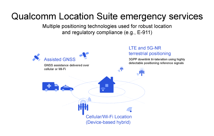
To comply with Federal Communications Commission (FCC) E-911 regulations, Qualcomm Technologies has enhanced its Qualcomm Location Suite to provide improved horizontal and vertical positioning information. The upgrade will help first responders better determine the floor within a multi-story building from which an emergency call was placed.
The Qualcomm Location Suite is deeply integrated with Qualcomm’s Snapdragon Mobile Platforms and Snapdragon Modem-RF Systems that power millions of mobile devices in the U.S. The suite has supported emergency location services in the U.S. and globally for two decades.
The change will help mobile service providers comply with new E-911 regulations requiring that the horizontal and vertical position of each wireless caller be determined with a certain level of precision.
The Qualcomm Location Suite uses GNSS with network-based positioning and dead reckoning to deliver accurate location with speed and efficiency. GNSS assistance is delivered over cellular or Wi-Fi, LTE and 5G-NR terrestrial positioning; cellular/Wi-Fi-based location is also provided.
When an emergency call comes in, operators rely on a combination of triangulation of wireless signals and device positioning technologies, such as GPS, to provide the position of the caller. The use of technologies in the Qualcomm Location Suite is designed to result in highly accurate positioning information and the ability to share this reliable information with first responders, allowing them to reach the precise emergency site more quickly.
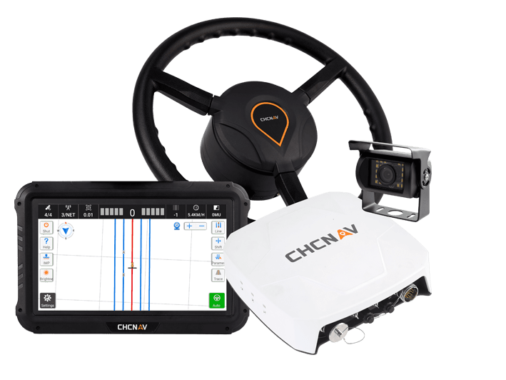
High accuracy and economical steering solution for most tractors in any field type
Photo: CHCNAV
CHC Navigation (CHCNAV) has released the NX510 Pro, a high-accuracy automated steering system designed for tillage, seeding, fertilization, pesticide application, and harvesting. With a steering controller and full GNSS RTK capability, the NX510 Pro can be quickly and easily mounted to various types of tractors and other farming vehicles to achieve ±2.5 cm pass-to-pass accuracy.
“The NX510 PRO is the new generation’s auto-steering system, engineered to dramatically reduce installation time, simplify daily operations and increase the productivity of farms of all sizes,” said Yorke Tang, product manager of CHCNAV’s Precision Agriculture division. He said the NX510 Pro allows farmers to afford a high-performance yet affordable auto-steer kit to retrofit their tractors to optimize their work, reduce input costs and fuel consumption, and meet the main goals of sustainable agriculture:
Increase farm income
Promote environmental stewardship
Enhance the quality of life for farm families and communities
Increase production for human food needs
Installation of the NX510 Pro auto-steering system to a tractor. (Photo: CHCNAV)
Quick installation. NX510 PRO takes less than one hour from installation start to operator use. The entire system can be installed in 30 minutes and calibrated in about 15 minutes, significantly reducing downtime costs in the field.
The intuitive AgNav software controls operations. It supports multiple guidance patterns to fit field layouts, including Straight AB line, A+ line, circle line, irregular curve and headland turn. It eliminates steering errors and overlapping passes on the field. The AgNav software also features real-time remote technical support from the local dealer’s help desk.
Powered by local, network or satellite-based RTK corrections, the GNSS+INS terrain compensation technology ensures ±2.5 cm hands-free accuracy on any terrain. The advanced controller ensures full RTK accuracy in seconds, provides smooth auto-steering and ensures repeatable long-term accuracy.
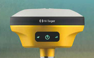
Hi-Target has introduced a new GNSS receiver, the V200. The V200 is a GNSS RTK receiver with an integrated nine-axis inertial measurement unit (IMU). The receiver is designed to provide superior performance and high-efficiency to support fieldwork with reliable solutions.
The advanced RTK engine and new-generation nine-axis IMU guarantees a 25% performance improvement over the company’s previous V100 model, even in demanding environments. It is designed to be easy to use and carry.
A smart Hi-Fix function supports the receiver to increase stability. Hi-Fix enables continuous connectivity and quality results even if the signal is lost while using an RTK base station or VRS network under extreme circumstances.
Advanced RTK Technology features
Full constellation support (receives GPS, GLONASS, Galileo, BDS, QZSS, SBAS, IRNSS)
800+ channels
9-axis IMU for better tilt survey performance
Increases productivity by 25%
Convenient Features
Lightweight at 820 grams
Can work continuously for more than 12 hours
Supported by the latest Hi-Survey Road software and smart Hi-Fix function
The V200 nine-axis IMU GNSS RTK receiver represents a step forward in the development of GNSS receivers towards miniaturization, according to maker Hi-Target.
Admiral Lord Alan West of Spithead has served the United Kingdom as First Sea Lord and led the government’s efforts for counter terrorism and cybersecurity. He has been a member of the House of Lords since 2007 and has stayed engaged with defence and maritime issues. RNT Foundation President Dana A. Goward spoke with him in early September about the UK’s way forward for GPS-like services.
DG: The UK government has been talking for years about the nation’s vulnerability to disruption of space-based signals such as those from GPS and Galileo. What is being done about it?
LW: Unfortunately, the government is not being as transparent as we might like on this. I do know from comments made in the House of Lords that there is a group developing a strategy. Also, that the Cabinet Office — our equivalent of the National Security Council in the United States — is deciding who is to be in charge and how things will be run.
I have heard the strategy group will propose a mix of technologies such as has been discussed in the United States. The idea of having several different systems, I am sure, is so that something interfering with one won’t disrupt them all.
This is all supposed to published in November. But I am concerned that government distractions with COVID, Afghanistan and other issues will delay that.
DG: What about the OneWeb project? That doesn’t seem to be waiting for a November announcement. And there is talk it may provide GPS-like timing and navigation services.
LW: OneWeb is moving forward, but at present it is only about 5G and making it available more quickly and broadly. There may be a OneWeb Phase 2 that includes modified or additional satellites to provide positioning, navigation and timing (PNT), but that is to be decided.
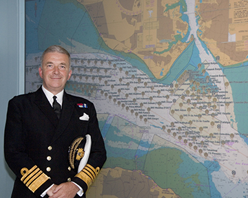
Admiral Sir Alan West, then First Sea Lord, is pictured with the official chart of anchorages for the International Fleet Review. (Photo: DP Kilfeather’s book Trafalgar 200 Through the Lens, Queen Elizabeth II 80th Birthday Edition, CC BY-SA 2.5)
DG: How about the UK rejoining Galileo?
LW: Actually, that makes a lot of sense from a practical point of view for both the UK and Europe. Unfortunately, there were a lot of hurt feelings on the continent with Brexit, some EU leaders seemed to be in punishment mode, and expulsion from Galileo was part of the fallout. I think that in due course as tempers cool, we will fully re-engage with the European Space Agency.
DG: So, no UK project for a GPS equivalent?
LW: The government allocated £90 million to that, which enabled a thorough look at the idea but was woefully inadequate to even start a project. Doing a British version of GPS or Galileo would be hugely expensive and doesn’t make sense. There are better, cheaper ways of getting what we need.
DG: And what does the UK need? What is the goal?
LW: We need several things.
First, we need a global capability that is ours, or that we are closely partnered in, to support the UK’s worldwide military and economic interests.
We also need to have something in place so that, even if space is denied to us — and that is getting to be more and more of a threat each day — we can keep our industries, critical infrastructure and economy going at home.
And third, we need a resilient PNT capability as a foundation for current applications, and to build on for such things as autonomy, intelligent transportation, and the like.
DG: So how do you get there?
LW: For the global bit, the OneWeb, and perhaps an even closer partnership with the United States on GPS.
At home, we definitely need a sovereign capability for when space is denied by solar weather or our adversaries. Also to be a check on space signals because our adversaries and criminals are spoofing them more and more.
I have always thought eLoran was a good choice. The UK pioneered its development and had the world’s first operational system in 2015. It is really hard to interfere with the signal, and there are other features that could be added to it that would make it even more robust.
There was a very interesting report called MarRINav put out last year about what UK maritime needs to ensure it can navigate regardless of whether the satellites are working or not. They came up with a reasonably inexpensive combination of systems anchored by eLoran.
By the way, it is interesting that the MarRINav study was funded by the European Space Agency. They seem to understand that satellites are not the be all and end all for PNT services.
DG: That all seems pretty straightforward and the right thing to do. What’s standing in the way?
LW: Well, so few people understand the problem. The population as a whole is almost completely unaware. At some level government understands all 13 of our critical infrastructure sectors could be impacted, but the people senior enough to drive action have dozens of other issues to deal with that probably seem more urgent.
DG: I wonder what it will take to make it seem urgent enough.
LW: Let’s hope the wakeup call is something short of a national disaster.
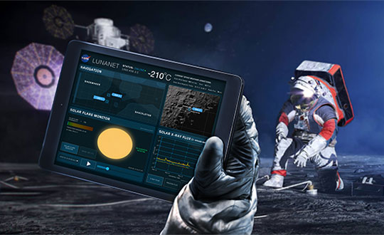
A GNSS receiver is scheduled to land on the Moon in 2023, sent by NASA and the Italian Space Agency (ASI). The innovative GPS and Galileo receiver, provided by Qascom, will experiment with satellite-based positioning on the lunar surface.
The project, dubbed NEIL (Navigation Early Investigation on Lunar surface), is at the center of an agreement between ASI and NASA, linked to the CLPS 19-D mission (NASA’s Commercial Lunar Payload Service, Task Order 19).
The NEIL payload will be integrated into the Lunar GNSS Receiver Experiment (LuGRE), an ASI/NASA cooperation framework to develop activities in lunar and cislunar environments.
For the first time in history, GNSS positioning will be tested at almost 400,000 kilometers from Earth. The previous limit was a distance of 200,000 kilometers, tested in the Magnetospheric Multiscale (MMS) project.
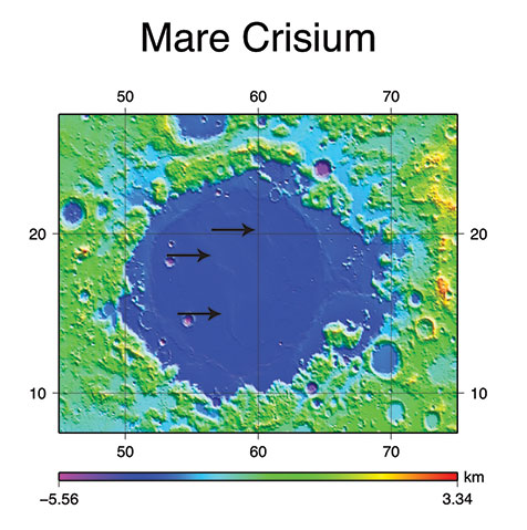
NEIL will be integrated on the NASA’s Blue Ghost lunar lander in 2022. In addition to the NEIL payload, nine other experiments will land on the Moon. The mission is expected to be launched via a SpaceX Falcon 9, and the lander with aim for the Mare Crisium basin.
Image: NASA/Resse Patillo
Moon-Hardened Receiver
Under an ASI contract, Qascom will develop the dual-frequency GPS and Galileo receiver, as well as the entire radiofrequency chain (antenna, LNA, filters), all of which can withstand the extreme environmental conditions of the Moon.
The GPS and Galileo signals received from NEIL will be extremely weak due to the distance from Earth, and will be processed with specific algorithms allowing to calculate position and time, even if with reduced accuracy, both during the Moon transfer orbit and on its surface.
Image: NASA
“This experiment is of strategic importance for Italy, since it will bring our technology to the Moon surface,” stated the Italian Space Agency. “It contributes to strengthening the competitiveness of the Italian space sector and consolidates the strong collaboration between the Italian Space Agency and NASA in the satellite navigation segment as well as in the future Moon and Mars missions.”
NEIL provides also an important technical and scientific contribution to study how GPS and Galileo could be used for positioning and timing in future Moon missions, including for example the deployment of lunar satellite constellations, lunar rovers, the lunar space station Gateway and the infrastructures that are going to be developed in the frame of Artemis programs. The raw measurement collected will be used by the research community to study the lunar and cislunar environment and evaluate the future use of GNSS to support permanent missions.
An unmanned MQ-25 T1 test asset refueled a third U.S. Navy carrier-based aircraft, demonstrating the maturity of the aircraft’s design and performance
The U.S. Navy and Boeing used the MQ-25 T1 test asset on Sept. 13 to refuel a U.S. Navy F-35C Lightning II fighter jet for the first time, demonstrating the aircraft’s ability to achieve its primary aerial refueling mission.
This was the third refueling mission for the Boeing-owned test asset in just over three months, advancing the test program for the Navy’s first operational carrier-based unmanned aircraft. T1 refueled an F/A-18 Super Hornet in June and an E-2D Hawkeye in August.
“Every test flight with another type/model/series aircraft gets us one step closer to rapidly delivering a fully mission-capable MQ-25 to the fleet,” said Capt. Chad Reed, the Navy’s Unmanned Carrier Aviation program manager. “Stingray’s unmatched refueling capability is going to increase the Navy’s power projection and provide operational flexibility to the Carrier Strike Group commanders.”
During a test flight on Sept. 13, an F-35C test pilot from the Navy’s Air Test and Evaluation Squadron Two Three (VX-23) conducted a successful wake survey behind T1 to ensure performance and stability before making contact with T1’s aerial refueling drogue and receiving fuel.
“This flight was yet another physical demonstration of the maturity and stability of the MQ-25 aircraft design,” said Dave Bujold, Boeing’s MQ-25 program director. “Thanks to this latest mission in our accelerated test program, we are confident the MQ-25 aircraft we are building right now will meet the Navy’s primary requirement — delivering fuel safely to the carrier air wing.”
The T1 flight test program began in September 2019 with the aircraft’s first flight. In the following two years, the test program completed more than 120 flight hours — gathering data on everything from aircraft performance to propulsion dynamics to structural loads and flutter testing for strength and stability.
MQ-25 is benefitting from the two years of early flight test data, which has been integrated back into its digital models to strengthen the digital thread connecting aircraft design, production, test, operations and sustainment.
T1 will be used to conduct a deck handling demonstration aboard a U.S. Navy carrier in the coming months to help advance the carrier integration progress.
Boeing’s MQ-25 T1 test asset transfers fuel to a U.S. Navy F-35C Lightning II fighter jet Sept. 13 during a flight-test mission. The Navy and Boeing have conducted three refueling flights in the past three months, including an F/A-18 Super Hornet and E-2D Hawkeye. (Photo: Kevin Flynn/Boeing)
Javad GNSS has launched a new field receiver based on the technology implemented in its Triumph-3 chip, which was introduced in May.
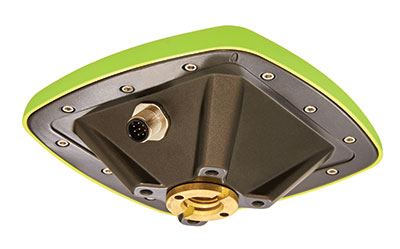
The MCAnt-3S receiver hosts 874 GNSS signal channels, allowing it to track all current and future GNSS signals. It can be mounted on flat surfaces with four screws or mounted on standard poles.
MCAnt-3S combines the receiver with a high-performance GNSS antenna in a compact and robust housing that is easy to mount, making it suitable for machine control applications. Communication is provided via CAN 2.0, USB 2.0 and RS-232/RS-422 interface.
Of the 874 channels in the Triumph-3 chip, 864 are general purpose GNSS channels and 10 are additional QZSS LEX channels. Each general-purpose channel consists of 10 correlators and a memory-code engine that allows reception of all existing GPS, GLONASS, Galileo, QZSS, WAAS, EGNOS and BeiDou signals with BOC and Alt-BOC capability. The memory-code engine is designed for existing truncated PN-code signals as well as future signals.
Before reaching the GNSS channels, the navigation signal goes through a sophisticated RF data-processing module. This module performs digital filtering of input signals to divide the spectrum by several frequency bands (L1, L2, L5, etc).
The module contains two special-purpose filters: an anti-jamming filter based on an adaptive LMS algorithm and a classic FIR filter to suppress static interference.
The fast-acquisition module combines four independent modules, each of which can search very long navigation signals (up to 16,284 symbols) with a sensitivity of -150 dBm and run as the equivalent of 130,000 correlators.
The U.S. Federal Contractor Registration System for Award Management (SAM) makes private companies such as Eos Positioning Systems eligible for federal contracts.
Eos Positioning Systems, global manufacturer of the Arrow Series GNSS receivers, is now certified on the U.S. Federal Contractor Registration (USFCR) System for Award Management (SAM) for NDAA 2019, Section 889.
SAM registration is required to bid on, and get paid for, federal contracts.
According to USFCR.com, “[USFCR] is the largest and most trusted federal registration and certification service provider. We manage and maintain your SAM registration and guarantee its federal compliance.”
In August, Eos Positioning released two new Arrow Series GNSS receiver models: the Arrow Gold+ and Arrow 100+. Arrow receivers are the company’s flagship products.
Interested persons can find the Eos Positioning Systems SAM registration using the CAGE code L0P52 and the Unique Entity ID (DUNS) 202882361.
Nearmap will capture aerial imagery of more than 80% of the U.S. population up to three times a year, enabling clients to access 130,000 square miles of additional content, including double the urban coverage of oblique/3D content
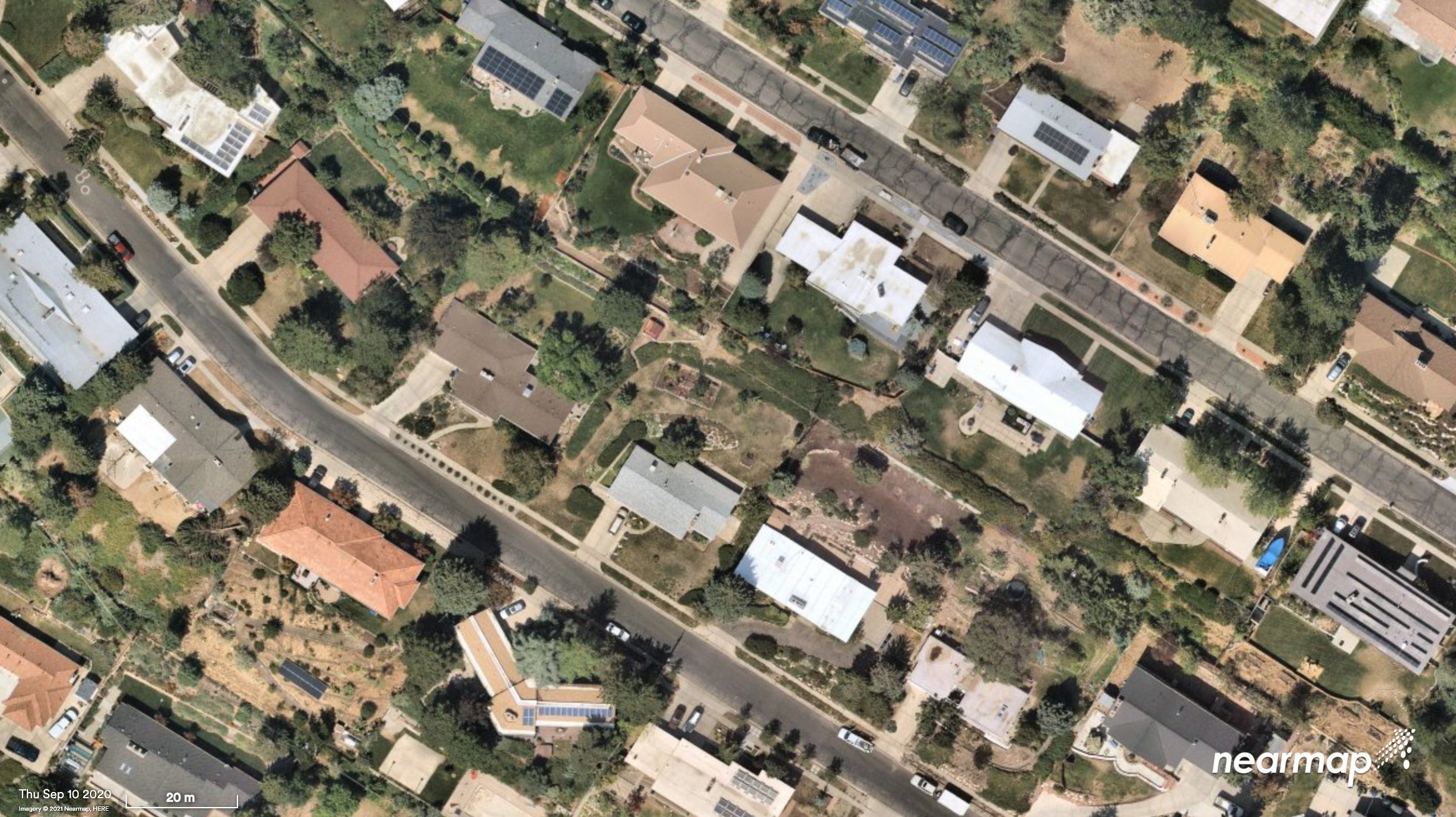
Aerial imagery and location intelligence company Nearmap has expanded its United States coverage program to more than 80% of the country’s population. This massive boost in coverage provides companies that rely on high-resolution aerial imagery with improved decision-making capabilities that will help them save time, effort and money, Nearmap stated in a press release.
“Nearmap customers have asked us to increase the amount of the U.S. that we cover and we’re responding by doubling down on our coverage,” Tony Agresta, general manager of North America, Nearmap said. “Our clients will have access to 130,000 square miles of additional unique captured footprint in the United States.”
Overall, the Nearmap capture program will cover more than 1,740 urban areas within the United States, including more than 80% of the population with 308,000 unique square miles captured annually.
In capturing aerial imagery, Nearmap focuses on currency, consistency, coverage and ease of access. The imagery is published within days of capture, with 24/7 access through a web app, API or third-party integration.
“Around 11,300 customers worldwide rely on Nearmap to be their eye in the sky, and to provide them with the truth on the ground,” Agresta said. “We’re seeing strong momentum with new and existing customers in the United States. This massive boost in coverage reflects the broader investment and focus Nearmap has on the strategically important U.S. market.”
Features of the expanded mapping coverage include:
130,000 square miles of additional unique captured footprint in the United States, equivalent to about 63,000 football fields
double the number of urban areas covered with oblique/3D content
access to current content, with updates up to three times a year, including leaf-off and leaf-on collection
images at a high resolution, ranging from 2.2 to 3 inches.
Across the world, Nearmap will also capture more than 64% of the population in Canada; more than 90% of the population in Australia, and about 73% of the population in New Zealand.
“The expanded aerial coverage complements our city-scale 3D content, artificial intelligence (AI) data sets, and geospatial tools,“ Agresta said. “Nearmap has also recently tested in flight the next generation of our patented aerial camera system, HyperCamera3, to ensure our clients are supported by the very best technology in the market.”
Under a new agreement, Lidar USA — a developer of geomatics solutions — will include Hesai Technology Co. Ltd., 3D lidar sensors in its product lineup. Hesai Technology announced the agreement at the Commercial UAV Expo 2021 in Las Vegas, Sept. 7-9.
The Pandar128 lidar unit. (Photo: Hesai)
Under the terms of the agreement, Lidar USA will leverage its marketing and sales expertise to distribute Hesai sensors across the United States, Canada and Mexico.
“Hesai’s product portfolio has the sensors we have all long awaited — bridging the gap between sensors made for automotive navigation and those made for precision measurement,” said Lidar USA CEO Jeff Fagerman. “Users will enjoy the affordability of the former and results of the latter.”
Hesai’s lidar units offer superior performance and reliability to ensure robust detection under different operating and environmental conditions, the company stated in a press release. Hesai’s XT sensors, embedded with proprietary lidar application-specific integrated circuits (ASICs), deliver performance advantages while maintaining a compact form factor and low cost.
The XT sensors are lightweight and draw less power, enabling longer operation for airborne applications. The XT’s precision and accuracy allows for fine detail capture.
PandarQT, a short-range sensor for blindspot detection, has a large vertical field-of-view of 104.2°. The Pandar series lidars — Pandar128, Pandar64 and Pandar40P — deliver long detection range, high resolution and high point density for optimized perception results.
“Lidars are increasingly being adopted for different end markets and applications,” said David Li, Hesai’s CEO. “We’re excited to partner with an industry leader like Lidar USA, whose strong foothold in North America will help expand access to sensors across different segments.”
New flagship offering can be mounted on a light manned aircraft or switched to different types of UAV platforms
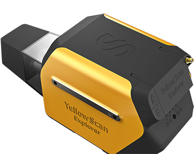
Photo: YellowScan
YellowScan, a designer of UAV lidar solutions, has launched the YellowScan Explorer. The Explorer can be mounted on a light manned aircraft or switched to different types of UAV platforms. The compact, versatile, long-range platform allows users to tackle a wide range of projects and mission profiles.
The Explorer’s high-power laser scanner can catch points up to 600 meters away, yet its low weight (2.3 Kg without battery) provides users with an integratable system. Combining Explorer with YellowScan’s full suite of software solutions to extract and process point cloud data provides users with a highly accurate set of tools for surveying, forestry, environmental research, archaeology, industrial inspection, civil engineering and mining.
The Explorer comes with an Applanix APX-20 UAV GNSS/inertial solution, precision of 2.6 cm and accuracy of 2.2 cm. Flight operation speed is 5 m/s to 35 m/s and it is capable of above-ground-level (AGL) altitude up to 300 m. Designed to be mounted on fixed-wing UAV, multi-rotor UAV or manned aircraft (light plane and helicopter), Explorer can enable a large variety of mission profiles.
YellowScan launched the Explorer during Commercial UAV Expo 2021 in Las Vegas, Sept. 7-9.
“We have been working on Explorer for the last three years, building on everything we have learned and achieved to date from a hardware, software and component integration perspective,” said Nassim Doukkali, R&D project manager, YellowScan. “One of the elements we are most proud of is the laser scanner, which has been designed according our specific specifications. With a maximum range of 600 m, the Explorer has exceeded YellowScan’s initial expectations.”
In 2017, YellowScan took part in a research project called FRELON (“French long range lidar”), funded by the European Regional Development Fund. The goal was to develop a new standard for long-range lidar by bringing together innovative specialists like YellowScan to collaborate directly with Airbus Defense and Space, Delair, M3 Systems and utility end-users EDF, RTE, Enedis and SNCF to develop the next-generation solution to meet their requirements.
“We are proud to finally release Explorer,” said Tristan Allouis, CTO, YellowScan. “This is our answer to the market’s need for a single long-range, yet compact, lidar unit that can be mounted on light manned aircraft and various UAV platforms.”