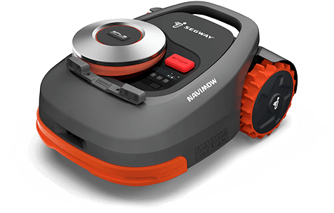
Segway has launched a smart lawn mower, the Navimow. The autonomous mower uses GNSS to navigate and stay inside the programmed perimeter, set in an accompanying smartphone app.
According to Segway, Navimow uses a GNSS-based “Extra Fusion Locating System” that help the mower achieve centimeter-level positioning accuracy while mapping out a working perimeter. Rather than using a perimeter wire to prevent the lower from leaving grid, Navimow combines multi-sensory data to create a virtual map while cutting grass in addition to using GNSS.
The company has introduced four models, for lawns ranging from 500 square meters to 3,000 square meters. All cut lawns from 30-60 millimeters on a maximum slope of 45 degrees.
During its runtime, the robot uses its smart navigation system and intricately plans the most effective cutting route. When necessary, it can make changes in direction to create a systematic pattern.
Velodyne Lidar will display its lidar sensors and software at the IAA Mobility trade show, which takes place Sep. 7-12 in Munich.
Showcased are:
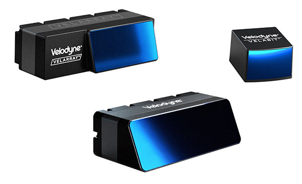
Velarray H800, a solid-state lidar sensor architected for automotive grade performance. With combined long-range perception and a broad field of view, the sensor is designed for safe navigation and collision avoidance in ADAS and autonomous mobility applications.
Velarray M1600, a solid-state lidar sensor designed to serve mobile robotic applications, enables touchless mobile and last-mile delivery robots to operate autonomously and safely, without human intervention.
Velabit, Velodyne’s smallest sensor, designed for versatility and affordability to 3D lidar perception.
Velodyne Lidar’s Intelligent Infrastructure Solution addresses the pressing need for smart city systems that can help improve road safety and prevent traffic accidents. The solution creates a real-time 3D map of roads and intersections, providing precise traffic monitoring and analytics that is not possible with other types of sensors like cameras or radar.
Partners Using Velodyne
NI, developer of automated test and automated measurement systems, is co-exhibiting at the Velodyne booth. NI is showing simulations optimized for Velodyne’s lidar sensors that can be used in developing and testing advanced driver assistance systems (ADAS) and autonomous vehicle (AV) capabilities.
NI will demonstrate how its monoDrive AV simulation software is using Velodyne’s lidar technology to create digital twins and is providing validated physics-based sensor models for Velodyne lidar sensors.
Seoul Robotics, an Automated with Velodyne partner, is demonstrating at the Velodyne booth its AI perception engine for Velodyne’s lidar sensors. The engine provides real-time object detection, classification, tracking and prediction for autonomous systems.
The AI engine can power self-driving cars as well as smart-city applications and advanced parameter monitoring systems for facilities. Seoul Robotics’ SENSR perception software includes an AI engine that is fully optimized to utilize Velodyne’s portfolio of lidar sensors, including the Puck, Ultra Puck and Alpha Prime.
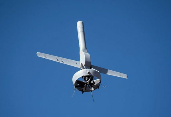
Northrop Grumman and Martin UAV (a Shield AI company) have completed successful flight testing of a V-BAT unmanned aircraft system (UAS) with new features including GPS-denied navigation and target designation capabilities.
The enhanced V-BAT’s flexible vertical take-off and landing (VTOL) capability is based on a platform deployed to address the U.S. Army’s Future Tactical Unmanned Aircraft System (FTUAS) mission. For FTUAS, the U.S. Army is seeking a rapidly deployable, GPS-denied navigation-capable, expeditionary VTOL system capable of persistent aerial reconnaissance for U.S. Army brigade combat teams, special forces, and Ranger battalions.
The offering is based on Martin’s UAV V-BAT UAS. According to Northrop Grumman, it is compact, lightweight, simple to operate, and can be set up, launched and recovered by a two-soldier team in confined environments. The V-BAT also is designed with sufficient payload capacity to carry a range of interchangeable payloads, including electro-optical/infrared (EO/IR), synthetic aperture radar (SAR), and electronic warfare (EW) payloads, depending on mission-specific requirements. Additionally, Shield AI’s recent acquisition of Martin UAV will enable rapid development of GPS-denied and autonomy capabilities for V-BAT through the future porting of Shield AI’s autonomy stack, Hivemind, onto V-BAT.
Northrop Grumman and Martin UAV conduct flight testing of Martin UAV’s V-BAT aircraft for the U.S. Army’s Future Tactical Unmanned Aircraft System effort in Camp Grafton, North Dakota. (Photo: Northrop Grumman)
The Air Wolf just prior to Burns Flat dawn launch. (Photo: Kratos)
Kratos Defense & Security Solutions, a provider of national security solutions, has announced that its Air Wolf Tactical Drone System has completed a 100 percent successful flight at the recently approved Burns Flat, Oklahoma Range Facility. The Kratos Air Wolf Mission, which was the inaugural flight at the Burns Flat Range location, included multiple new payloads carried by the Air Wolf UAV, including a proprietary Kratos artificial intelligence/autonomy system, which has been developed by Kratos specifically for high performance, jet UAV aircraft.
Air Wolf is one of several drones in Kratos’ family of jet drones that are flying today, also including the attritable UTAP-22 Mako, XQ-58A Valkyrie, and, in conjunction with the company’s partner Dynetics, the reusable X-61A Gremlins drone. According to the company, the newly approved Burns Flat Test Range and Facility is an important new strategic asset available to it, enabling the company to accelerate its drone testing and demonstration, further increasing its ability to rapidly develop and demonstrate jet drones, supporting subsystems, and other tactical systems and aircraft.
Kratos develops and fields technology, platforms, and systems for United States national security-related customers, allies, and commercial enterprises. The company specializes in unmanned systems, satellite communications, cyber security/warfare, microwave electronics, missile defense, hypersonic systems, training, combat systems and next generation turbo jet and turbo fan engine development.
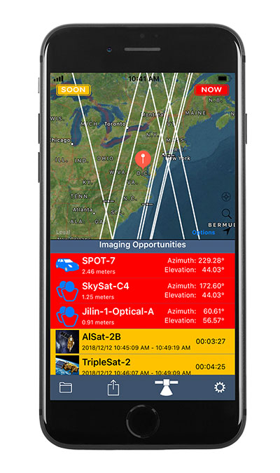
Orbit Logic’s SpyMeSat mobile app (available via the Apple App Store and Google Play) now includes an augmented reality (AR) interface for better awareness of overflying imaging satellites. The AR view overlays the orbit and position of satellites that can image your location, providing a better understanding of satellite viewing geometry and potential obstructions. For example, it makes it possible to know if an image taken by that satellite of your position would be obscured by a tree or a building. The AR interface also displays relevant information about the satellite and its capabilities, including the timing and dynamic geometry of the pass as well as the resolution achievable by satellite sensors.
In addition to real-time imaging satellite awareness, SpyMeSat provides on-demand access to recent archive satellite imagery and the ability to request new tasking directly from a mobile device. Multi-phenomenology data (optical, infrared, synthetic aperture radar, and more) is available through an in-app process of preview, select, payment, and delivery that can be completed in seconds, providing archived satellite imagery for any location on demand. When archive imagery is insufficient and new data is required, users can review available satellites, better understand the data collection environment through the AR interface, and purchase tasking based on cost, responsiveness, and capability.
While the standard SpyMeSat enables marketplace interactions between the public and commercial satellite imagery providers, Orbit Logic also develops custom mobile applications for better situational awareness and easier data-access/tasking supporting specific missions. The new AR interface will enhance these users’ mission effectiveness by facilitating better understanding of how data collection might be impacted by surrounding terrain or other spatial factors. Examples of bespoke SpyMeSat deployments include government versions for government assets and versions for awareness of satellite communications opportunities for contact scheduling, data transfer, and command uplink.
Orbit Logic specializes in mission planning and scheduling solutions for aerospace and geospatial intelligence. Its COTS products create better plans faster with fewer resources for all mission phases. Orbit Logic services are available to configure, customize, and integrate its mobile, web-based, desktop, and flight software applications to provide turn-key operational solutions that leverage the latest available technologies to meet customer goals and exceed their expectations.
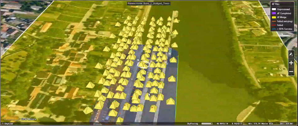
EagleView, a geospatial technology provider of software, aerial imagery and analytics, and Skyline Software Systems, a provider of 3D Earth visualization software, have partnered to enable customers to visualize their geospatial data in new ways. Through this new partnership, EagleView’s high-resolution ortho and oblique imagery can be converted into 3D Mesh layers with Skyline’s PhotoMesh and viewed, edited, and analyzed on Skyline’s TerraExplorer platform.
EagleView customers will be able to utilize Skyline’s TerraExplorer web-based GIS viewer and editor to see, analyze, and share their imagery in an immersive environment. Accurately measuring distance, area, and volume is now easier than ever, which is critical for planning and zoning to verify regulations or estimate the costs of flattening a site. With floodplain analysis, disaster management can identify flood risks before they happen, and with viewshed calculations E911 can pre-plan for high-profile events. Other key analytic features for customers will include the ability to analyze shade, view contour and slope maps, and view in underground mode. Beginning immediately, the additional 3D Mesh capability is now available as an add-on to any new Reveal Essentials+ Property or Neighborhood image capture.
Skyline offers a comprehensive platform of applications, tools, and services that enable the creation and dissemination of interactive, photo-realistic 3D environments. Its products are production proven in both the defense and commercial markets.
EagleView develops geospatial technology, providing software, imagery, and analytics. The company has the largest geospatial data and imagery library in history, covering 94 percent of the U.S. population. Its technology with more than 300 patents creates highly differentiated software, imagery, and analytics products for a diverse customer base.
The U.S. General Services Administration (GSA) has selected Hexagon US Federal as a prime contractor for ASTRO, a 10-year, indefinite-delivery/indefinite-quantity (IDIQ) contract with an estimated $90 billion value.
The ASTRO contract is being administered by the Federal Systems Integration and Management Center (FEDSIM). Sponsored by the Department of Defense (DoD), ASTRO is comprised of 10 pools to deliver services related to manned, unmanned and optionally manned platforms and robotics.
Hexagon was selected as one of multiple awardees for the Data Operations Pool, which includes all data collection, processing, exploitation, and dissemination activities associated with manned, unmanned, and optionally manned platforms and/or robotics supporting mission performance. The formal government kick-off is anticipated to take place in November 2021.
Hexagon is a provider of digital reality solutions, combining sensor, software, and autonomous technologies, putting data to work to boost efficiency, productivity, quality and safety across industrial, manufacturing, infrastructure, public sector and mobility applications.
Hexagon US Federal provides technology and professional services for C5ISR, installation security, GIS, and cyber security. Dedicated to the delivery of Hexagon technology and services to the U.S. government, including defense, intelligence, and civilian organizations, the company builds solutions that help its customers design, build, maintain, manage, operate, and protect.
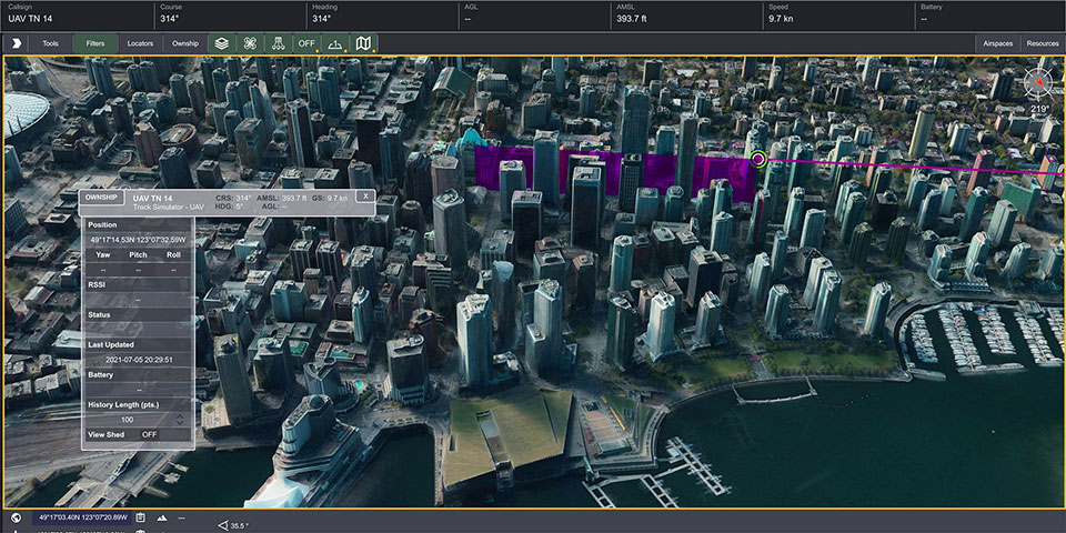
Kongsberg Geospatial has released TerraLens 9.3, the latest version of its real-time software development toolkit for geospatial visualization. In this release of TerraLens, the product development team has focused on improving performance for 3D visualization for large viewports and on multi-domain visualization features for joint all-domain command and control applications. Leveraging the power of modern GPUs and multi-core processors, the latest release of TerraLens is significantly faster, with new presentations focused on enhancing situational awareness.
With increased multithreading in its map handling, TerraLens can load and display vector, raster, and elevation formats smoothly without pre-processing. This is ideal for applications that have disk size constraints or for customers that have a short turn-around time between receiving map data updates and needing to use them. For applications with stringent start-up constraints or map formats that are not optimized for quick runtime access, the pre-processing option still exists, to help ensure minimal time for an initial map display.
The rendering of maps and dynamic presentations has also been optimized with increased threading in the graphics kernel, and the minimization of costly graphics state changes with batched rendering calls. Improved data culling ensures that only visible items will be rendered. These improvements are especially noticeable when displaying large numbers of dynamic tracks and objects, and frequently projected information.
This release of TerraLens also includes a slate of new tools and features, including support for OGC 3D Tiles, which can be used to create a high-resolution 3D view that is especially suited to cityscapes, while a new API to control the resolution of the terrain mesh allows applications to balance runtime performance with higher resolution terrain over which to drape map imagery. Elevation warnings can now be displayed using color ramps on both terrain and OGC 3D Tiles, as well as on primitive lines and area fills.
TerraLens continues to evolve to meet the latest map and symbology standards. Support has been added for the latest military symbology, providing MIL-STD-2525D and App-6B symbol sets. The SDK also features new mapping updates including enhanced support to discover WMS and WMTS map layers as well as monitoring the status of web requests. Support has been added for DAFIF 8.1 and S-57 Inland ENC levels. Developers will be able to track when maps have completed loading in the TerraLens viewport. TerraLens 9.3 also continues to support the latest development environment needs, including Visual Studio 2019, CLI .Net Core, and Linux RedHat8.
TerraLens has been fielded in some of the most demanding applications in the world including AEGIS, Global Hawk, THAAD, NATO AWACS, and the Joint Battle Command-Platform.
Based in Ottawa, Canada, Kongsberg Geospatial creates precision real-time software for air traffic control and UxS and situational awareness. The company’s products are primarily deployed in solutions for air-traffic control, command and control, and air defense. During nearly three decades of providing dependable performance under extreme conditions, Kongsberg Geospatial has become the leading geospatial technology provider for mission-critical applications where lives are on the line. Kongsberg Geospatial is a subsidiary of Kongsberg Defence & Aerospace.
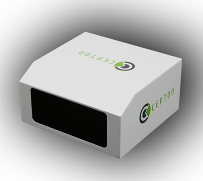
Cepton, a provider of automotive lidar solutions, will showcase its automotive-grade, long-range Vista-X90 lidar device at two upcoming tradeshows in Europe: IAA Mobility 2021 in Munich, Germany (September 7-12) and AutoSens in Brussels, Belgium (September 15t-16).
Photo: Ception
Vista-X90 combines high performance, auto-grade reliability and low cost to meet the critical requirements for mass-market automotive applications. During both events, Cepton representatives will be available to talk about Cepton’s lidar offering for a range of smart mobility applications, including advanced driver assistance systems (ADAS), autonomous vehicles (AV) and smart infrastructure.
With a compact and embeddable design, Vista-X90 is optimized for ease of vehicle integration, offering multiple placement options, such as in the headlamp, in the fascia, behind the windshield, or on the roof. Featuring Cepton’s next-generation ASIC technology, the Vista-X90 supports AUTOSAR and over-the-air (OTA) functionality, with advanced capabilities for functional safety, cybersecurity, and extrinsic calibration.
Visitors to the Cepton booth at IAA and AutoSens will also be able to learn about Cepton’s award-winning lidar solutions portfolio that extends beyond automotive and supports smart infrastructure applications such as smart roads and rail, electronic tolling, and more.
Cepton provides intelligent, lidar-based solutions for a range of markets such as automotive (ADAS/AV), smart cities, smart spaces, and smart industrial applications. Cepton’s patented MMT-based lidar technology enables reliable, scalable and cost-effective solutions that deliver long-range, high-resolution 3D perception for smart applications.
Founded in 2016 and led by industry veterans with more than two decades of collective experience across a wide range of advanced lidar and imaging technologies, Cepton is focused on the mass market commercialization of high performance, high quality lidar solutions. Cepton is headquartered in San Jose, California, USA, with a presence in North America, Germany, Japan, India, and China, to serve a fast-growing global customer base.
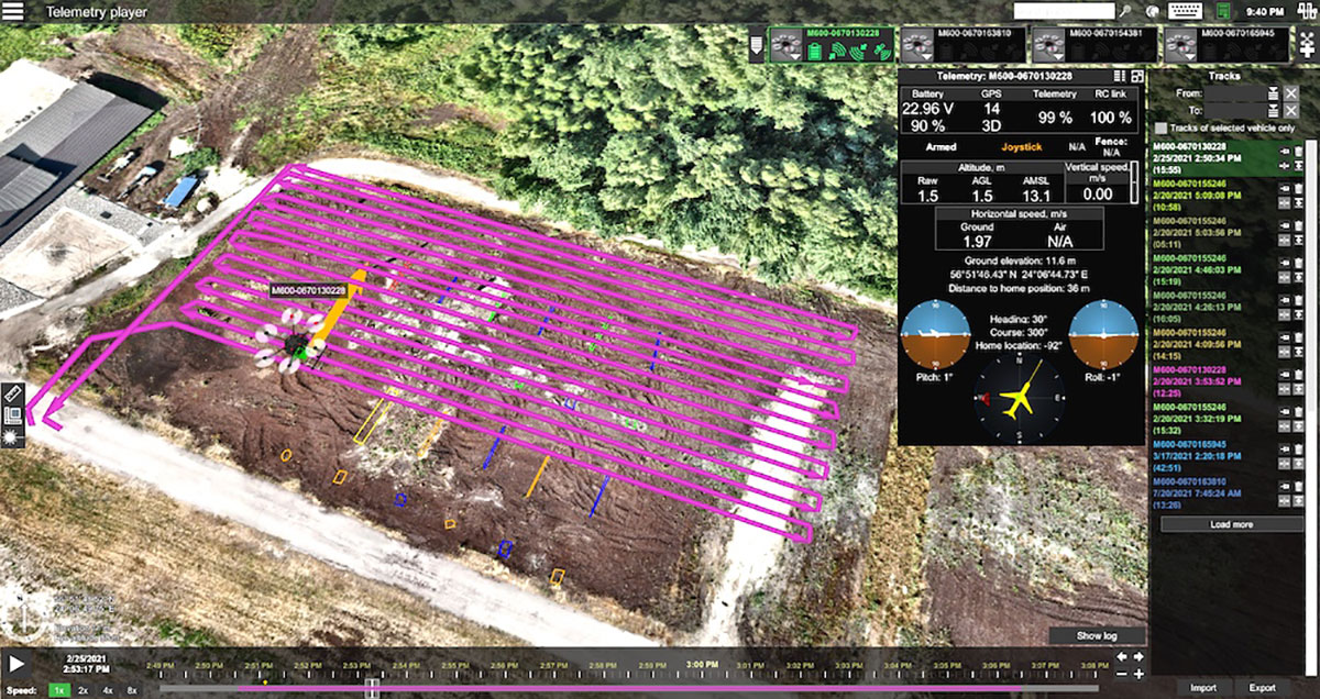
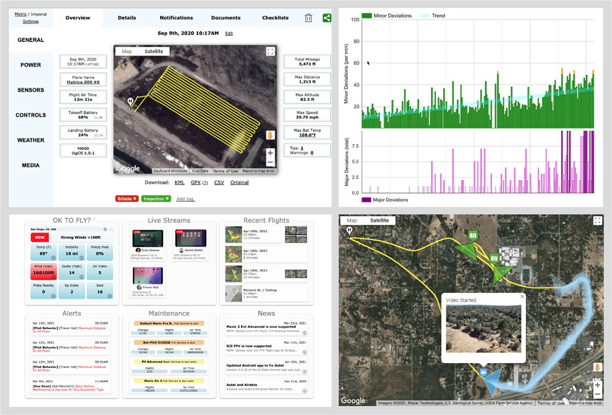
Telemetry view of drone survey mission in UgCS. (Image: SPH Engineering)
SPH Engineering and AirData UAV have partnered to offer pilots a way to track and manage their fleets by automatically synchronizing flight data from SPH Engineering’s UgCS to AirData.
SPH Engineering and AirData have worked closely to provide an automatic method to synchronize flight logs with AirData. The new integration will transmit detailed and comprehensive flight information from UgCS and will leverage AirData’s crash prevention algorithms, pilot and equipment alerting, as well as maintenance tracking with no manual steps required.
UgCS by SPH Engineering is a tool for enhanced UAV mission planning and flight control software solution. Today, it is used in more than 150 countries in a wide range of areas including environmental, archeological, engineering and mining, agricultural and biological. The UgCS Educational program aims to support universities with a safe and efficient tool to test innovative ideas involving surveying and inspecting with a drone. SPH Engineering is a multiproduct drone software company and UAV integration services provider.
AirData is an online drone fleet data management and real-time flight streaming platform, serving more than 200,000 users with 19 million flights uploaded to date, processing an average of 20,000 flights a day, with high-resolution data stored per each flight. It is used by large fleet operators around the world not only as a logbook, but also as a comprehensive flight safety data analysis and crash prevention platform, with advanced maintenance, pilot tracking and live streaming.
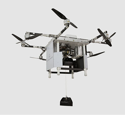
A2Z Drone Delivery LLC, developer of a patented tethered freefall drone delivery mechanism, has launched its RDSX commercial delivery UAV.
The company delivered the UAV in collaboration with a global logistics provider to deliver dual payloads per flight, helping drone service providers streamline deliveries while mitigating consumer concerns with residential drone delivery. The RDSX integrates A2Z Drone Delivery’s proprietary tethered freefall Rapid Delivery System capable of quickly and safely delivering payloads from altitudes as high as 150 feet. By keeping spinning rotors far from people and property, the RDSX helps mitigate consumer concerns with drone deliveries—such as the potential for property damage and intrusive rotor noise—and assuages some of the privacy concerns with low-flying unmanned aerial vehicles.
A2Z Drone Delivery will be showcasing the new RDSX at the Commercial UAV Expo (September 7-9, 2021 in Las Vegas, NV).
The RDSX is a flexible drone delivery platform capable of carrying dual payloads each weighing up to two kilograms on a round trip of up to 18 kilometers. Alternatively, it can be configured with a single tether to expand its range out to 30 kilometers. The controlled-freefall delivery method it employs allows UAV service providers to reduce time-on-station to a minimum by delivering the package to the ground in seconds and eliminating the need for the drone to touch down. By maintaining its altitude throughout the delivery, the RDSX keeps spinning rotors away from people and property, mitigating consumer concerns and enabling it to deposit payloads into areas congested by trees, wires, or other dangerous obstructions.
The integrated A2Z Drone Delivery app combines manual control system operations with an onboard computer and sensor array to manage the package’s controlled-freefall and gentle stop before the ground. With the package delivered, the RDSX’s Kevlar tether and auto-release mechanism releases the payload before being reeled back up for reuse.
A2Z Drone Delivery’s freefall delivery technology has previously been leveraged for residential drone delivery trials, deployment and retrieval of ground sensors for energy exploration, as well as for shore-to-ship port delivery. The technology is equally applicable for first responders delivering life-saving medicine, for search and rescue professionals quickly deploying equipment to remote areas, or for rapidly collecting samples throughout an expansive mining facility.
The RDSX leverages a proven UAV flight platform equipped with a pair of cameras allowing pilots to navigate beyond visual line of sight (BVLOS). Additionally, the system features an independent downward-facing LiDAR sensing system to stream continuous data to the onboard firmware which controls the payload’s rapid descent and allows the pilot to visually monitor payloads through flight and delivery. Featuring quick-swap bucket-style batteries to limit downtime between flights, the RDSX can operate in diverse conditions including temperatures ranging from -20 to 45 Celsius, in up to 95% humidity, and from elevations up to 4,800 feet. Additionally, the RDSX’s eight rotor arms, fitted with durable carbon fiber propellers, can fold away for easy transport of the drone.
With its patented delivery system, A2Z Drone Delivery, LLC is developing innovative solutions to enable safe, accurate and low-noise drone deliveries. Its flagship delivery system, the RDS1 (Rapid Delivery System) enables payload delivery and retrieval to locations where most UAVs are unable to land, and its RDSX is a commercial multi-payload delivery system designed to meet the needs of the growing drone delivery industry. Based in Los Angeles, A2Z Drone Delivery originated as a drone delivery project at Brown University in 2016.
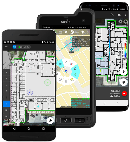
TRX Systems was awarded funding through the National Institute of Standards and Technology (NIST) Public Safety Innovation Accelerator Program (PSIAP) to test, validate and harden the TRX NEON Personnel Tracker solution to support wide-scale public safety deployment. TRX is partnering with the Arlington County Fire Department (ACFD) to conduct extended testing during which the TRX 3D location technology will be used by all personnel at Station 5, serving Pentagon City and Crystal City, to validate usability and performance and to better align the solution with first responder needs.
Through a previous NIST PSIAP award, TRX improved the accuracy and capabilities of its NEON Personnel Tracker solution. With this subsequent Technical and Business Assistance (TABA) award, TRX will take the next steps toward wide-scale deployment by validating and tuning the NEON solution in a challenging live environment. Combined, these projects aim to accelerate the availability of improved 3D location accuracy, easy to use 3D map data tools, and actionable 3D visualizations for first responder use cases.
Over the course of this program, TRX will partner with ACFD to conduct an 8-month field trial that exercises the TRX NEON Personnel Tracker solution 24 hours a day, 7 days a week in a fully operational environment. The key objectives of this extended deployment are to identify and close any gaps that could inhibit widescale deployment, validate usability and tracking accuracy, and demonstrate the operational feasibility and value of the solution.
First responders typically operate in environments that are indoors, underground, or in other areas where reliable access to GPS signals is impeded. TRX’s NEON Personnel Tracker system delivers reliable and real-time 3D location in these GPS-denied environments by using patented mapping and tracking algorithms that fuse inertial sensor data to compute the user’s path and position. This solution lets on-scene and remote commanders track the real-time location of personnel during an incident, helping them to ensure the safety of their teams and improve the efficiency of their response.