Are military tests that jam and spoof GPS signals a threat to the safety of civil aviation? If not, why? If so, who should do what about it?
Bernard Gruber
“I would offer that military tests that jam and spoof signals are a risk. The U.S. military takes great care to control tests of this nature in an informed and careful way in order not to affect civil aviation. I cannot speak for military tests that are conducted by other countries. We all recognize the worldwide proliferation of small and large jammers that can negatively affect GPS performance and satellite-born transmissions. Accordingly, GPS users should remain vigilant to these potential hazards, including spoofing, and consider alternative navigation means where risks dictate.” — Bernard Gruber
What are the remaining obstacles to creating a seamless indoor/outdoor positioning and navigation system that integrates data from GNSS, inertial guidance, indoor positioning systems, and signals of opportunity?
John Fischer
“The primary use case for indoor navigation is the smartphone. We can create multi-sensor navigation systems today that operate indoors, but not at the very small size, weight, power, and cost targets needed for the personal phone market. IMUs and processors continue to improve over time, so there may be a breakthrough there, but signals of opportunity (SoOP) navigation is promising and offers resiliency through diversity. The most ubiquitous SoOP is cellular and with ultra-reliable low latency (URLL) features coming on-line for 5G in the next few releases, we may see reliable positioning from 5G in indoor environments very soon.” — John Fischer
Aerial imagery company Nearmap is partnering with Geographic Technologies Group (GTG), which helps local government agencies throughout the United States and Canada with geographic information systems (GIS).
GTG offers local governments with GIS services including strategic planning, consulting, comprehensive data services, mapping services, software development, training and on-call support. GTG also provides ongoing GIS maintenance for villages, towns, cities, counties, multi-regional agencies, public works and public utilities, water districts, and Native American and Alaskan Tribes.
“Our range of high-resolution aerial content — from vertical to oblique, 3D and AI [artificial intelligence] — integrates easily with GTG’s applications and acts as a valuable component to the strategic planning services offered by GTG,” said Karl Terrey, director, Global Alliances at Nearmap. “Our imagery is refreshed multiple times per year and, when combined with GTG’s technology, allows cities, towns, counties and state governments to make decisions based on conditions in their communities in near real time, at a fraction of the cost.”
Nearmap’s 3D imagery provides local governments with the ability to quickly export custom areas for use in platforms such as Esri, Bentley Systems and Autodesk. Nearmap AI enables governments to instantly identify attributes about properties required for the appraisal process. Nearmap AI Packs enable users to determine the type of access made visible in MapBrowser for items such as impervious surfaces, vegetation and solar panels at citywide scale.
Nearmap’s library of aerial imagery provides some of the most accurate imagery available with updates occurring up to three times a year throughout more than 430 markets in North America, including 700 urban and regional areas accounting for more than 70 percent of the United States population.
“Our goal has always been to break through boundaries, solve problems, and introduce a new kind of decision support for our clients,” said James Kelt, vice president of corporate software at GTG. “We began using Nearmap’s aerial imagery a few years ago because we recognized it as a way to differentiate ourselves and push the envelope. Our clients love the imagery and the more we worked with Nearmap, the more it made sense to find a way to partner so we could provide this added value to all of our customers.”
Central Italy — already home to an ambitious national autonomous driving research initiative — will be the site of the P-CARS laboratory, intended to certify positioning devices for use within driverless cars.
The new P-CARS laboratory is financed by the Italian Space Agency (ASI) through the Navigation Innovation and Support Programme (NAVISP) of the European Space Agency. The lab will support the goals of EMERGE, a public-private partnership for innovation established in 2018 between Italy’s Ministry of Economic Development, the University of L’Aquila and the mountainous Abruzzo region. Also in the partnership are the RadioLabs research consortium and the Leonardo, Telespazio and Elital companies.
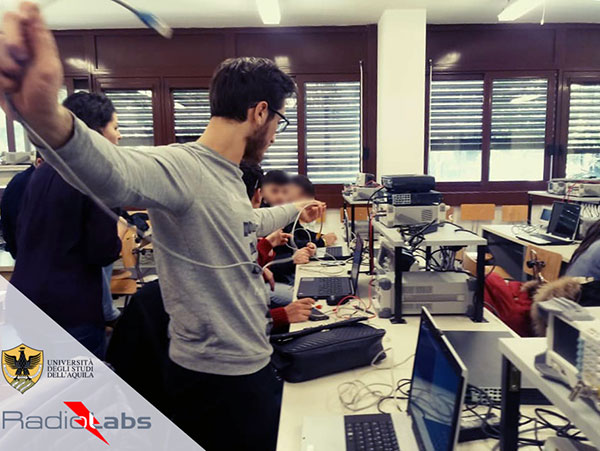
RadioLabs laboratory at the University of L’Aquila, part of Italy’s EMERGE initiative developing autonomous and connected driving solutions. (Photo: RadioLabs)
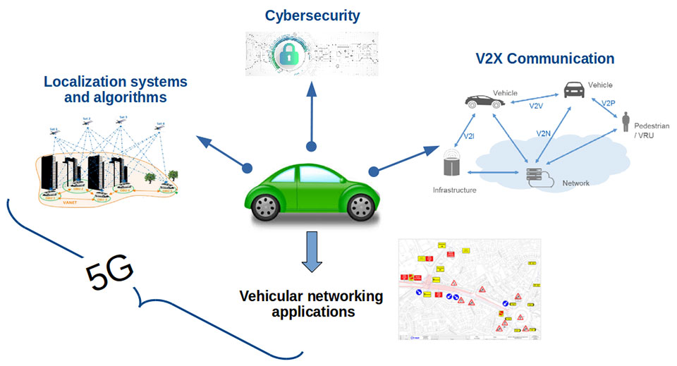
EMERGE will develop satellite navigation and 5G solutions for connected, cybersecure and autonomous vehicles. The new P-CARS laboratory will be an independent venue for testing devices supporting autonomous and connected driving.
“The idea behind it is to create a research ecosystem, focused on developing, testing, validating and promoting the use of Galileo and other GNSS — along with 5G communications — for connected and autonomous driving,” said Francesco Rispoli, chief satellite operations at Hitachi Rail STS and director general of RadioLabs.
Abruzzo already hosts a manufacturing site for Stellantis’ Fiat Ducato light truck, the Galileo control center at Fucino, and the connected-car center of the University of L’Aquila. P-CARS will be integrated into the university’s Center of Excellence for Geo-localized, Connected and Cyber-secure vehicles.
Italy’s EMERGE initiative is developing GNSS and 5G technology for autonomous and connected driving. (Image: RadioLabs)
“The P-CARS lab will have a 150-square-meter testbed area, beside an existing driving circuit, with the right to use the surrounding open space as well,” Rispoli said. “We’ll be addressing connected autonomous driving functions with GNSS technologies that are safety critical, the key point being that safety must be ensured through standardized test procedures, serving as a trusted third-party to validate specific solutions from companies.”
“This is a valuable response to our national strategy, promoting the adoption of positioning, navigation and timing (PNT) solutions in the fast growing automotive sector by leveraging the latest technologies brought by Galileo and 5G,” said Alberto Tuozzi, head of ASI’s Navigation and Telecommunication Department. “Cross fertilization, cooperation and interaction among the stakeholders will be pursued in the unique ecosystem of the Abruzzo region, bringing together space and non-space stakeholders: ASI, ESA, satellite and automotive industries, universities and research centers.”
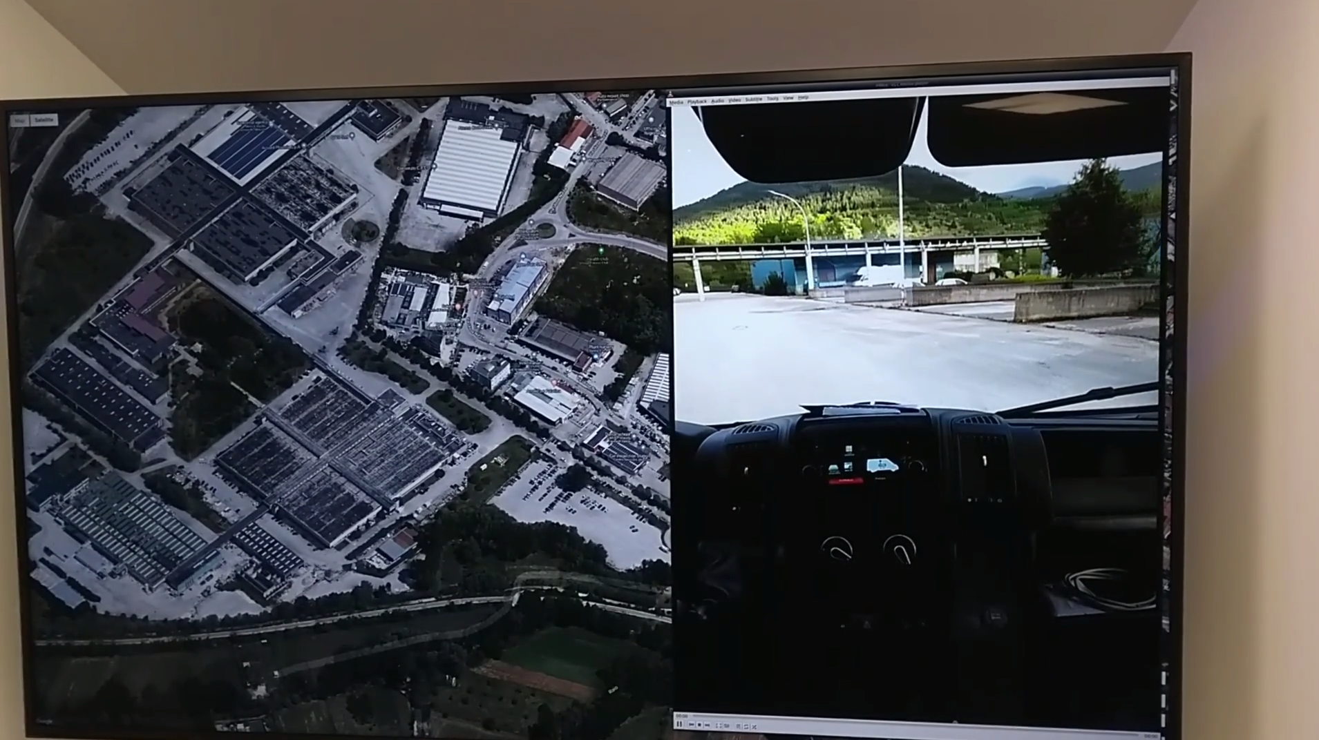
Autonomous vehicles will have two distinct sets of inputs: sensors such as cameras, lidar and radar to know the context around the car; and GNSS and inertial measurement systems to know its position. The two sets work independently but come together to ensure safety. (Photo: RadioLabs)
Leveraging its expertise on Galileo and safety applications, ESA will support this initiative in two ways: with technical support and through cooperation and exchanges with other institutions and laboratories at the international level. ESA said P-CARS could become part of a network of centers of excellence in the PNT domain applied to autonomous cars and beyond.
P-CARS will exploit the synergies between the rail and automotive sectors to provide benefits to both. “Car manufacturers produce millions of vehicles and are investing heavily in autonomy and safety systems, but had little experience in this field before they began investing a few years ago,” Rispoli said. “Meanwhile, the rail community has almost 20 years’ experience managing train driving functions with a high degree of autonomy, through the common European Rail Traffic Management System, ERTMS.”
Hitachi Rail and Rio Tinto collaborated to build the world’s first driverless heavy freight train – an automated heavy haul freight transportation system delivering freight from mines to ports in Australia across thousands of kilometers every day. (Photo: Hitachi Rail)
“It is well recognized that ERTMS guarantees the highest safety levels as a connected and autonomous driving system, where the human driver is largely bypassed, but not the volume for mass producing such systems for reducing their cost. By leveraging these two peculiarities it will be possible to get low cost but safety-proven GNSS-based devices,” Rispoli said.
The emphasis will be on connectivity, with the vehicles linked to the infrastructure, including a centralized system of intelligent roads as well as other cars. 5G will enable low-latency communications and be a source of positioning data to extend the performance of GNSS.
P-CARS is being supported through Element 3 of NAVISP, focused on supporting ESA member states’ navigation priorities.
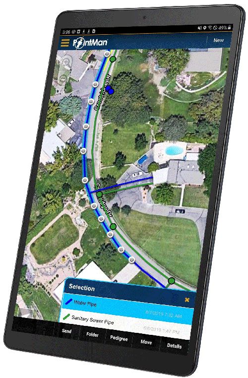
Precision-mapping company ProStar Holdings Inc. has integrated its PointMan software into the Vivax Metrotech vLoc3 with a GNSS real-time kinematic (RTK) receiver to create a utility-locate device.
Using the RTK-Pro internal cellular module with 4G LTE capabilities, the operator can connect to the NTRIP RTK caster that provides RTCM 3 corrections.
With the integration of PointMan with the vLoc3 RTK-Pro, critical buried infrastructure can be captured, recorded and displayed at survey-grade without additional external equipment or post-processing. The integration provides centimeter accuracy of the precise location of buried utilities in real time.
Data collected includes the type of utility, the depth of cover and the utility’s precise location.
Javad GNSS announces that, after a short retirement, Tom Hunter has rejoined the company as chief sales officer. Hunter will draw on more than three decades of GNSS industry experience, most recently with Javad GNSS and previously with Ashtech/Magellan as vice president.
“Tom is key to our operations,” said Nedda Ashjaee, CEO. “I am looking forward to reigniting this group of companies and continuing our four-decade tradition of bold innovation. Who better to do this with than the person who helped my father build the original company in the first place?”
Hunter will oversee sales channel development in support of a new market-driven roadmap developed by the executive team at Javad GNSS, also known as J-CORE.
Hunter’s association with Javad began in 1987 as one of the original seven people at Ashtech, Ashjaee’s namesake firm created shortly after his departure from Trimble Navigation. The firm brought numerous surveying industry firsts and other legendary products to market.
Company founder Javad Ashjaee passed unexpectedly in May 2020, leaving behind 200 loyal employees in offices around the globe. A strategic thinker, Ashjaee was known for operating “several steps ahead,” said one employee, having groomed his executive office and other support staff for a swift takeover in the event he were unavailable. Javad’s daughter Nedda, familiar to all who had conducted business with the firm, has spent the last 12 months carefully restructuring the business plan.
On March 31, Nedda Ashjaee, Tom Hunter and the rest of the J-CORE team hosted a two-day virtual gathering of global Javad GNSS dealers, technicians and other personnel, taking time to unveil the firm’s new strategic vision. The information and overall strategy was met with an overwhelmingly positive response.
Javad GNSS retains significant patent holdings relating to survey and mapping and offers what many of its customers believe to be one-of-a-kind system(s).
Hunter explained, “If you’re a surveyor or other positioning professional working with GNSS, you owe a debt of gratitude to Javad — the man dedicated his life to developing GNSS for the high-precision marketplace. You can see his hand in nearly every major GNSS survey system on the market today.”
“As we continue to develop and introduce new products in support of the surveying and reference station markets, we will use our exceptional technology and our U.S.-based world-class manufacturing facility to focus on new OEM applications and opportunities including strategic partnerships and private labeling,” Hunter said.
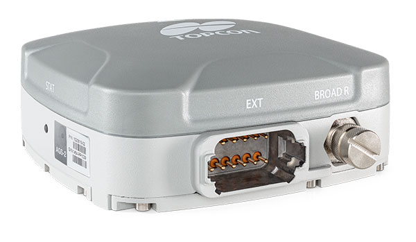
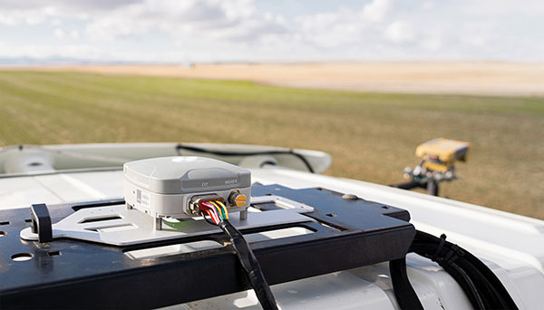
Topcon Agriculture is offering new manual guidance and autosteering receivers — the AGM-1 and AGS-2.
Topcon also launched Topnet Live, a real-time GNSS correction service. Under Topnet Live, the Realpoint service provides greater accuracy and a quick start-up time. Starpoint and Starpoint Pro provide service anywhere on the planet, independent of local networks. Skybridge allows subscribers to combine RTK and PPP correction services.
Accurate positioning is the cornerstone of site-specific management. It is not only required for accurate operations, but expansive data collection, enabling farm professionals to compare different types of information, such as yield, soil type and fertility, for better decision making.
The technology is used for machine operations and all associated tasks where tracking location data is relevant to crop optimization, including soil preparation, seeding, crop care and harvesting.
Photo: Topcon
Topnet Live. To support the range of agricultural applications, the receiver and steering controller uses the new Topnet Live correction services. Plus, with the option of Skybridge, users can maintain network connection during any RTK interruption.
“Topcon receivers are designed to suit virtually any agricultural machine type, make and model,” said Brian Sorbe, vice president of global product solutions. “Equipped with progressive reception and tracking capabilities, with the option of manual guidance or complete autosteering, the receivers are suitable for any size or type of operation. With access to the full range of correction services through the AGS-2, Topcon provides farmers with the right fit for their operation with accuracy on demand. Each unique farming operation may have differing accuracy requirements and this approach will benefit their operation.
“Calibrated to accuracies of within two centimeters, the new correction services provide reliable pass-to-pass precision,” Sorbe said. “Through a constantly improving network and variety of cost-effective subscription models, the service delivers reliable connection stability across the globe. With these new offerings, Topcon continues to offer powerful solutions to suit the variable demands of agriculture.”
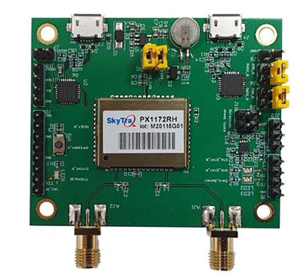
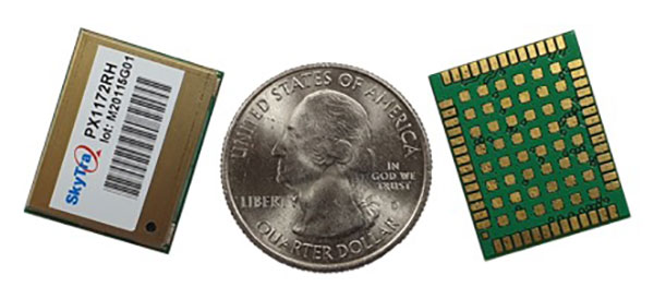
SkyTraq is offering a new multi-band, multi-GNSS receiver module for real-time kinematic (RTK) positioning and heading applications, suitable for autonomous vehicles. The PX1172RH surface-mount receiver measures 17 x 22 mm, about the size of a postage stamp.
With dual-antenna input, the PX1172RH receiver delivers sub-degree heading and pitch or heading and roll angles on top of centimeter-level positioning under both dynamic and static conditions. This removes the dependency on vehicle movement to initialize an inertial measurement unit (IMU) for attitude determination.
The PX1172RH is unaffected by magnetic surroundings and does not require calibration. It offers higher heading reliability and performance than magnetic heading sensors or single-antenna GPS sensors.
Photo: Skytraq
The PX1172RH works with dual-frequency GPS/QZSS L1/L2, GLONASS L1/L2, Galileo E1/E5 and BDS B1/B2 GNSS signals concurrently to enable robust positioning and heading performance under challenging partial-sky environments and to provide RTK convergence in seconds. The PX1172RH is suitable for autonomous precision-guidance applications.
A PX1172RH sample, datasheet and evaluation boards will be available in May, with mass production scheduled for June.
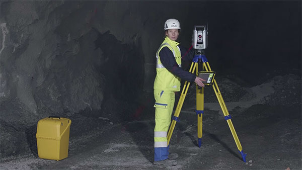
Trimble and Amberg Technologies are collaborating to provide a tunnel survey solution. The combined hardware and software solution will enable construction, mining professionals and surveying service providers in underground environments to make use of a complete field-to-office workflow.
The Trimble and Amberg solution enables tunnel surveyors to perform a variety of underground tasks such as excavation guidance, control, automated survey and stakeout of different tunnel elements using design information. In addition, it delivers a comprehensive module for digitalization of tunnel construction and further optimization of related processes.
The tunneling solution combines the robustness and the speed of the Trimble S series robotic total stations with the user-friendly workflows of Amberg Navigator field software running on a ruggedized Trimble TSC7 data collector or T100 tablet. The streamlined workflows are optimized for non-geospatial professionals, helping to keep tunneling and underground projects on time.
In the office, the designs from the Amberg Tunnel office software can be transferred to Amberg Navigator, either directly or using the cloud. Following the data collection and stakeout operations, the information is sent back to the office for detailed analysis, where inspection maps and reports can be produced as final deliverables inside Amberg Tunnel office software. This streamlined process can bring significant time and resource savings due to a more efficient workflow and easy-to-use interface.
The solution provides a full-featured workflow for tunnel construction surveys including:
project definition and design data preparation
graphical interface supporting instruments setup and georeferencing
automated data collection and real-time results
accurate stakeout of various tunnel elements (drill and blast holes, rock bolts)
efficient and comprehensive as-built analysis, reporting and archiving.
“Partnering with Amberg Technologies will provide our customers with an industry-leading tunneling solution to increase productivity when working in underground tunneling and mining environments,” said Ron Bisio, senior vice president of Trimble Geospatial. ”The domain-rich and easy-to-use Amberg solution in combination with our Trimble S series can increase confidence in the field and streamline deliverable creation.”
“Together with Trimble high-end surveying sensors, we can enrich our comprehensive tunnel solution with a more versatile offering and even better, address specific needs in ever more demanding construction environments,” said Svein G. Vatslid, CEO, Amberg Technologies AG.
The solution is expected to be available through Trimble’s Geospatial distribution channel in North, Central and South America this month.
Two recent reports from the Organization for Security and Co-operation in Europe (OSCE) have described a recent increase in GPS jamming, presumably by Russian or pro-Russian forces in Ukraine. This comes as Russia has increased its troop numbers and activity along its border with Ukraine.
OSCE is charged with a Special Monitoring Mission (SMM) in Ukraine which observes and reports on how well both sides are adhering to the Minsk Protocol agreement. The agreement was signed in September 2014 by participants in the conflict in an effort to end open hostilities.
One of the ways the OSCE mission monitors activity and compliance in the region is with long range UAVs. As early as November 2014, the organization reported UAV operations being thwarted by interference with GPS signals.
Two recent OSCE spot reports have highlighted a resurgence in jamming.
An April 7 report described interference that prevented a UAV takeoff the previous day. While the organization’s UAVs had been experiencing increased interference since March, this was the first time since October 2014 that it had thwarted a mission before takeoff.
The report also documented an increasing level of jamming activity.
“Over the last two months, 62.5 percent of SMM long-range UAV flights encountered GPS signal interference and on 75 percent of the affected flights it occurred more than once.”
A second report on April 9 outlined continuing problems that caused missions to be aborted. It emphasized that this was a violation of the agreement signed by all parties and greatly hampered OSCE’s mission.
“Any GPS signal interference hinders the Mission’s ability to conduct effective monitoring and reporting of the security situation in line with its mandate. Long-range UAVs are an essential part of SMM operations, especially at night and in areas where the Mission’s monitoring and freedom of movement are restricted.”
GPS jamming and spoofing are important parts of Russia’s arsenal to counter any technological advantage the west may have over their forces. A 2015 Sputnik article bragged their electronic warfare kept U.S. cruise missiles from hitting their targets at the start of the 2003 invasion of Iraq. Also, that this advanced capability “renders aircraft carriers useless.”
Interference with GPS signals is a regular feature of Russian military and internal security operations.
The United States has formally expressed concerns about the recent increase in the number of Russian troops and their activity at the Ukrainian border. It has been reported that two U.S. Navy ships are on their way to the Black Sea to help monitor the situation.
Dana A. Goward is president of the Resilient Navigation and Timing Foundation.
Acculink Cargo provides a near real-time visibility, global tracking and exception-based monitoring asset tracking to serve the $30B+ global market.
Sierra Wireless has launched Acculink Cargo, a new managed internet of things (IoT) solution that companies can quickly deploy to track the location and condition of high-value and sensitive assets.
Delivered as a service for a single monthly fee, Acculink Cargo leverages Sierra Wireless’ expertise in IoT devices, global connectivity and the cloud to deliver a service companies can use to monitor the near real-time status of assets anywhere in the world, as they move through their supply chains.
Acculink Cargo enables electronics manufacturers, cold-chain carriers, general freight carriers, food and produce shippers and third-party logistics firms to gain the supply-chain visibility they require to avoid shipping delays, minimize dwell time, prevent theft and remediate environmental conditions that can lead to asset damage. In addition to tracking the location of these assets, Acculink Cargo can also alert customers if an asset is exposed to light, changes in temperature, humidity, shock, or other conditions that might spoil or otherwise damage it.
Drawing on more than two decades of experience in the IoT market, Sierra Wireless has designed Acculink Cargo to address the three key needs facing companies as they seek to track high-value and sensitive assets — real-time visibility, product-level tracking and exception-based monitoring.
Acculink Cargo benefits include:
Quick deployment. Acculink Cargo fully integrates edge devices, global network connectivity and a cloud-based application, supporting quick deployment in as little as 30 days with minimal startup costs.
Highly accurate tracking. Use of LTE cellular wireless networks in combination with GPS data enables customers to pinpoint the location of their assets.
Flexibility. The cloud-based application features an intuitive user interface with customizable dashboards and configurable alerts.
Configurable location and status reporting. Users can set up specific geolocation, light, temperature, humidity and shock conditions to monitor for each shipment. Users can also adjust when data on these conditions is updated, allowing them to extend the battery life of their edge devices.
Insights. Users can analyze real-time and historical shipping data to uncover trends that can help them make better business decisions.
“When it comes to high-value and sensitive assets, companies no longer want to just track their location as they travel through their supply chains. Today, they expect to be able to monitor the condition of these assets in near real-time as well,” said Rupal Nanavati, vice president and general manager of IoT applications, Sierra Wireless. “Acculink Cargo addresses these needs, with an easy-to-deploy, fully integrated managed solution from the global leader in IoT.”
Pricing. Acculink Cargo is sold on an as-a-service basis, allowing customers to easily scale the solution up or down as their business needs change. Customers can purchase devices up front, and pay for connectivity and the application on a subscription basis. Or, they can sign up for a complete managed IoT service, with a single monthly fee that covers devices, network and application access.
Acculink Cargo is currently available to customers throughout North America. Sierra Wireless plans to expand availability of the solution to other regions.
Parrot drones professional users benefit from an advanced control during complex fleet operations
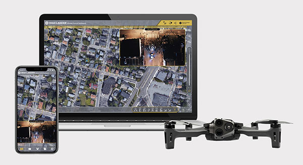
Drone company Parrot is partnering with High Lander, which provides drone fleets with autonomous flight, intelligent airspace control, and coordinated air continuity through its Mission Control platform.
Combining Parrot ANAFI USA and ANAFI platform drones with High Lander’s Mission Control software, professionals can now access drone features through an easy-to-use dashboard.
“Parrot is continuously striving to provide our professional users with extended capabilities — allowing them to rapidly adapt their drone operations to fit their changing and urgent needs,” said Jerome Bouvard, Parrot director of strategic partnerships. “Drone automation and intelligence are at the heart of our product and software developments. This new partnership with High Lander represents another step towards enhanced automation and control capability of our drones.”
Using real-time device reporting and telemetry, first responders can autonomously manage their drone fleets while performing takeoff and landing, route-planning, and other crucial tasks — all from the intuitive comfort of the Mission Control Operations Center dashboard. The software’s seamless interface paired with the ANAFI USA’s ease-of-operation and rapid deployment provide more safety for responders and allow faster intervention during critical moments. Mission Control’s customized live link generation can also provide team-members onsite with an instant view of a drone’s video feed for fast assistance during search-and-rescue missions.
For surveying and mapping missions, operators can use improved control modes including Path (which sets an automated plan including multiple waypoints, telemetric, gimbal and payload settings) and Modeling & Mapping (which allows operators to survey an area in detail) as they efficiently create 2D maps and 3D models using Parrot ANAFI’s precise GPS coordinates capabilities.
Operators can also benefit from Mission Control’s Payload Sidebar, which enables switching instantly to thermal imaging, an invaluable tool for missions in search and rescue, police pursuits, or solar panel inspections. Parrot ANAFI USA’s integrated FLIR Boson Thermal sensor and 32x zoom make it easy to identify thermal anomalies and centimetric hot spots from an altitude of up to 40 meters.
“As a hardware-free system, Mission Control is compatible with leading drone manufacturers’ solutions, now including Parrot, to provide our customers with the freedom of customizing their drone fleets with best-in-class UAVs,” said High Lander CTO Ido Yahalomi.
High Lander is working with a number of prominent organizations including police departments, sheriff’s offices, fire stations, and forestry services, and has 12 active clients who will now be able to use Parrot’s ANAFI USA and ANAFI drones in their fleets.
The High Lander Pilot app is available for download on Android and iOS systems for use with ANAFI and ANAFI USA platform drones.
For more information about ANAFI USA, contact Parrot through the ANAFI USA contact form.
The T100 tablet is designed for use in the field. (Photo: Trimble)
Rugged tablet operates seamlessly with Trimble Site Positioning Systems and Trimble Siteworks Software
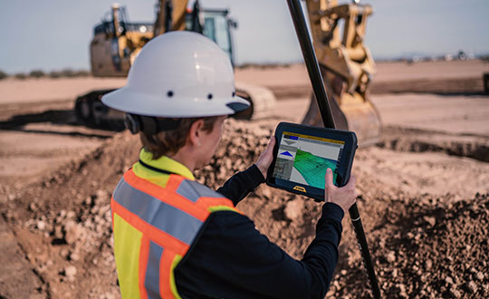
Trimble has announced the Trimble T100 Tablet, a high-performance tablet providing fast data processing for construction surveying applications. The rugged tablet brings fast computing and a large screen to the field, incorporating:
Directional keypad with programmable function keys
Large internal battery (92Wh)
Powerful Intel i5 processor for fast data collection, processing and quality assurance
USB-C fast-charging capabilities
Expandable dual EMPOWER module system, engineered to exceed the expectations of the outdoor field worker
User-configurable performance settings
IP-65 environmental specifications
Two bracket options for different display angles on the pole, enabling users to measure different locations more easily, with maximum flexibility for hard-to-measure locations
Optimized for Trimble Siteworks Software and supporting office applications such as Trimble Business Center, the T100 is suitable for both experienced and novice users. With accessories designed to specifically complement user workflows, the T100 avoids the burden of carrying multiple computing devices, while enabling users to complete quality assurance and quality control before leaving the field.
“The T100 tablet features the quality you expect from Trimble, with the flexibility to adapt to a variety of configurations and job site conditions,” said Scott Crozier, vice president of Trimble Civil Construction. “It is engineered to be ergonomic and portable on and off the pole, enabling users to stay mobile while they work, with features that increase productivity and reduce downtime.”
Earthworks Upgraded for Soil Compactors
Wider Range of Machine Types Now Available on the Trimble Earthworks Platform
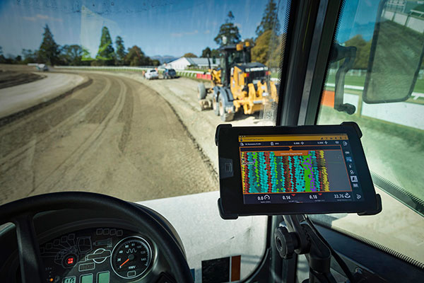
Trimble Earthworks for soil compactors is a GNSS-based, 3D compaction control solution designed to make soil compaction more accurate, faster and easier. Operators will experience the same intuitive, easy-to-use Trimble Earthworks software interface currently available for excavators, dozers and motor graders for improved productivity.
Trimble Earthworks now includes soil compactors. (Photo: Trimble)
Compaction Control. Trimble Earthworks for soil compactors enables contractors to accurately control the compaction process, while reducing unnecessary passes that can result in over compaction. The platform makes the overall compaction process more efficient, with a higher level of accuracy and less rework. With soil compaction part of the extensible Trimble Earthworks platform, contractors can take advantage of shorter training times, less downtime and increased remote operator support in the field as well as benefiting from ongoing platform developments.
“Trimble Earthworks for soil compactors is easy to learn and more accessible for many different types of users because it leverages the intuitive Trimble machine-control interface and applies it to soil compactors,” said Scott Crozier, vice president of Trimble Civil Construction. “Adding this new machine type to the Trimble Earthworks platform gives contractors the ability to more easily manage their mixed fleets, train operators and manage jobsite data.”
Improvements in material/surface lifts and layer management allow for more accurate data and easier data management. Office-to-field connectivity enables efficient communication and data transferring across the project. In the field and office, contractors can easily interpret the valuable productivity data collected from the machine, such as work previously completed versus work completed that day.