Reef Support, an automatic warning system that uses artificial intelligence (AI) and satellite imagery to detect coral bleaching, algal blooms, sediment plumes and debris caused by humans, won the Copernicus Masters 2020 competition.
The Reef Support team includes Crystle Wee, Yohan Runhaar, Marcel Kempers, Marijn van der Laan and Eilidh Radcliff.
Reef Support addresses both the environmental and economic aspects at hand with state-of-the art technology. Its user-friendly online monitoring and maintenance tool uses AI and satellite imagery to track coastal reef health and also provides guidelines for crowd and pollution control, debris management and coral restoration.
According to the team, different types of data can be combined to form a picture of reef ecology across a wide range of spatial and temporal scales. The Reef Support platform can be used for strategic planning and resource management in aquaculture farming, as well. Its deep learning algorithm adapts to user applications and regional tendencies.
The subscription-based service is available on both iOS and Android.
Celebrating its 10th iteration in 2020, the international innovation competition Copernicus Masters awarded prizes in 22 categories to outstanding products and services based on Earth observation data. In total, 591 participants from 47 countries submitted 220 new Earth observation business cases and application ideas.
“Copernicus Masters has proven to be the perfect instrument to reach entrepreneurs to become a reality in Earth observation and tackle challenges such as climate change, technology revolutions, shifts in geopolitical power or humanitarian crises, and to support economic growth, safety and security, quality of life and sustainable development,” said Jan Wörner, director general at the European Space Agency (ESA).
AZO launched the Copernicus Masters in 2011 on behalf of the ESA.
RedTail Lidar Systems partnered with an engineering firm to demonstrate the RTL-400 lidar system’s high-resolution, high-accuracy mapping capability.
Cross-section of lidar point cloud (Image: RedTail Lidar Systems)
According to the company, its lidar imagery was used to generate as-built conditions of a steep ravine to aid in long-term monitoring of the slopes under which a natural gas pipeline was buried.
A narrow road traversing the top of the ravine through which the pipeline was installed was of concern since the instability could be dangerous. Loss of vegetation along the buried pipeline’s path also makes the area especially susceptible to slides after heavy rainfall.
Top view of lidar point cloud (Image: RedTail Lidar Systems)
The RTL-400’s high-resolution point cloud data of the 13-acre ravine area was captured in 10 minutes, RedTail Lidar Systems said. The as-built digital elevation model (DEM) created from the lidar point cloud can be compared to future DEMs to determine if any changes have occurred in the slope’s topology, which would serve to identify hazards and provide input for slip mitigation.
RedTail Lidar Systems is a division of 4D Tech Solutions, a company focused on providing innovative technology-based solutions to address government and commercial customer needs.
SimActive Inc., a developer of photogrammetry software, has integrated its Correlator3D product into lidar systems for drones developed by Lidar USA.
Possible configurations include two side-by-side cameras that allow matching the footprint of the lidar sensor, a particularly useful setup for corridor mapping.
SimActive’s Correlator3D software is used for automatically registering the imagery with the lidar data. Once a perfect alignment has been achieved, the point clouds are colorized using the photos.
“The ability to directly use lidar as control for adjusting image positions really is a unique feature,” said Jeff Fagerman, CEO at Lidar USA. “Correlator3D allows our clients to quickly combine lidar with data from multi-camera systems and produce high-quality outputs.”
Correlator3D software is a patented end-to-end photogrammetry solution for the generation of high-quality geospatial data from satellite and aerial imagery, including drones. Correlator3D performs aerial triangulation and produces dense digital surface models, digital terrain models, point clouds, orthomosaics, 3D models and vectorized 3D features.
Powered by GPU technology and multi-core CPUs, Correlator3D’s processing speed supports rapid production of large datasets.
Lidar USA, also known as Fagerman Technologies, is a family owned business just outside of Huntsville, Alabama. Lidar USA specializes in laser scanning, photogrammetry, instrumentation and all things geomatics.
The Space and Missile Systems Center’s Production Corps achieved a major GPS milestone on Nov. 18 with the approval for Operational Acceptance of GPS Military-Code (M-Code) Early Use (MCEU). MCEU serves as a gap filler for M-code operations before the entire GPS constellation’s operational transition to the Next Generation Operational Control System Block 1.
The encrypted M-code signal enhances anti-jamming and anti-spoofing capabilities for the warfighter. M-code signals are available on all 23 GPS Block IIR-M, IIF and III space vehicles currently on orbit. The successful testing events were completed at the Master Control Station at Schriever Air Force Base, Colorado and Alternate Master Control Stations at Vandenberg Air Force Base, California.
Operational Acceptance followed successful integrated developmental and operational testing of the GPS Operational Control Segment (OCS) upgrade. Operating in a trial period since June 2020, the MCEU upgrade allows the OCS Architecture Evolution Plan to task, upload and monitor M-code within the GPS constellation, as well as support testing and fielding of modernized user equipment. With M-code now declared operational, upcoming Military GPS User Equipment (MGUE) will be able to request early use of the M-code signal-in-space to provide more secure position, navigation and timing (PNT) to warfighters.
“MCEU ushers in a new era of GPS support that will provide operators across the warfighting domain with assured PNT access while further preventing unauthorized use by our adversaries. This is a critical step in remaining the gold standard of PNT systems and promoting a peaceful, secure, stable, and accessible space domain,” said Lt. Jordan Malara, 2nd Space Operations Squadron GPS Warfighter Collaboration Cell assistant flight commander.
M-code designed for security
Military code (M-Code) is a more-secure, harder-to-jam and spoof GPS signal specifically for military forces. Awarded in September 2017, M-Code Early Use (MCEU) is a software upgrade to the OCS AEP, which allows the current ground control system to task, upload and monitor M-Code within the GPS constellation. It will also help Accelerating M-Code’s deployment supports testing and fielding of modernized user equipment in support of the warfighter.
MCEU includes a new software-defined receiver installed globally at all six Space Force Monitoring Sites. The M-code Monitor Station Technology Improvement and Capability (M-MSTIC) uses commercial, off-the-shelf hardware to cost effectively receive and process M-code signals, enabling OCS operators to successfully monitor the M-code signals.
“M-code’s more-secure, harder-to-jam and spoof signals are critical to helping our warfighters complete their missions, especially in contested environments,” said Maria Demaree, vice president and general manager for Lockheed Martin’s Mission Solutions line of business. “This upgrade to the current GPS ground control system, and the launch of more modernized GPS III satellites, is making M-code’s full-fielding a reality.”
With the Dec. 1 Operational Acceptance of GPS III Space Vehicle 04 (GPS III SV04), 23 GPS IIR-M, GPS IIF and GPS III satellites broadcast M-code in the current GPS Constellation.
Ground Control Timeline — OCS AEP
Lockheed Martin has sustained the Space Force’s current GPS ground control system since 2013. The system is known as the GPS Operational Control Segment (OCS) Architecture Evolution Plan (AEP) or “OCS AEP.”
In February 2016, the Air Force contracted Lockheed Martin to develop the GPS III Contingency Operations (COps) software upgrade to the OCS AEP. COps was delivered in May 2019, successfully connected with on-orbit GPS III SV01 in October 2019, and was Operationally Accepted in February 2020. COps enabled the Air Force’s ground control system to command and control both the legacy satellites, as well the more powerful GPS III satellites beginning to launch.
In November 2018, the company completed the AEP 7.5 upgrade — the largest architectural change in the systems history — replacing significant code, hardware and software to improve the system’s cybersecurity capabilities and positioning the Air Force to better operate in contested, degraded and operationally limited environments.
In December 2018, the Air Force awarded Lockheed Martin the GPS Control Segment Sustainment II (GCS II) contract to continue to further modernize and sustain the OCS AEP through 2025.
In the fourth quarter of 2019, Lockheed Martin delivered the Red Dragon Cybersecurity Suite (RDCSS) Phase III upgrade to the OCS AEP, dramatically improving Defensive Cyber Operations (DCO) visibility into GPS network traffic. Other add-ons include user behavior analytics to analyze patterns of traffic and network taps to improve data collections.
Earlier this year — and key to enabling M-Code — Lockheed Martin installed new software-defined M-Code Monitor Station Technology Capability (M-MSTIC) receivers at six Space Force monitoring sites around the world. In Dec. 2019, SMC granted security approval for M-MSTIC.
From his side window, a crew chief relays vital position information back to the CH-47 Chinook pilot as paratroopers hook their pallet of equipment to the underside of the helicopter during sling load and air operations training. (Photo: U.S. Army/Maj. Robert Fellingham)
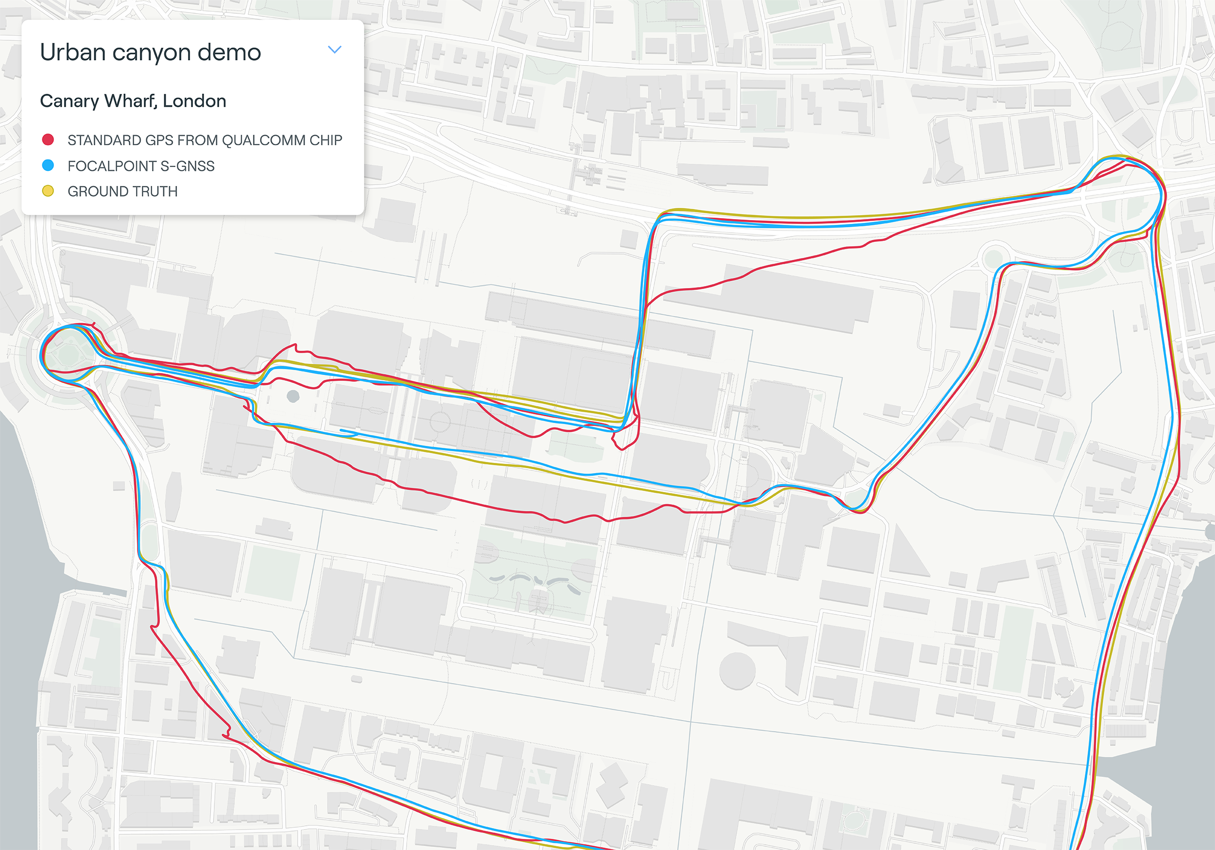
Map plot from live tests in London show the route of a vehicle driven through Canary Wharf. It shows the difference between the position provided by a standard smartphone GNSS chip (red line) and the same data run through Focal Point Positioning’s Supercorrelation software (blue line). (Image: u-blox)
U-blox has signed a deal with the award-winning U.K.-based technology company Focal Point Positioning to integrate technology that will improve the accuracy and reliability of GNSS devices. Focal Point’s Supercorrelation technology enhances positioning performance and security for applications such as smart cities, location-secure internet of things (IoT) and health and fitness wearables.
The patented Supercorrelation technology solves a critical weakness in GNSS caused by multipath interference. Multipath interference occurs when satellite signals bounce off buildings and landmarks, causing GNSS receivers to provide degraded positioning outputs.
The result for users is that the blue dot on their phone or device may be in the wrong place, moving in the wrong direction, or may have a large error ellipse. For autonomous vehicles it could lead to positioning errors that place the vehicle in the wrong lane or worse.
FocalPoint’s Supercorrelation technology uses software to detect and reject reflected signals, resulting in an improvement in the performance of GNSS devices without the need for additional hardware or applications. Supercorrelation also helps with the detection and rejection of GNSS spoofing signals — an increasing concern for autonomous vehicles, ships, and aviation.
“We are tremendously excited to be working alongside a market leader such as u-blox, our mission is to improve every positioning system on the planet and we have taken a giant step forward in that vision with this deal,” said Focal Point Positioning CEO Ramsey Faragher. “Positioning systems are so critical to our world, and we look forward to seeing the next generation of products and services that will be enabled by this higher level of accuracy, reliability and security.”
u-blox CEO Thomas Seiler commented, “The addition of Supercorrelation technology into our latest GNSS platforms is part of our continuing focus on low power consumption, higher accuracy and security for automotive, industrial, and wearable GNSS applications.”
Coalition gives voice to PNT companies seeking open-market approach to backing up GPS/GNSS for critical infrastructure
Several GNSS and positioning, navigation and timing (PNT) companies have joined forces to create a new lobbying group, the Open PNT Industry Alliance. Founding companies include InfiniDome, Iridium Communications, Jackson Labs Technologies, NAVSYS Corporation, NextNav, OPNT, Orolia, Qulsar, Satelles and Seven Solutions.
In the United States, the coalition believes the Executive Order on “Strengthening National Resilience Through Responsible Use of Positioning, Navigation, and Timing Services,” issued in February 2020 begins the process for a national alternative PNT policy.
The report was criticized by some lawmakers for inaccuracies and lack of depth, but several companies whose solutions were referenced in the report defended it, and have now joined in creating this new alliance.
The alliance expects to support similar initiatives in other countries.
The coalition is designed to fortify economic and national security by supporting government efforts to accelerate the implementation of backup PNT capabilities for critical infrastructure. Other companies sharing these views are invited to join the alliance.
The Open PNT Industry Alliance will be introduced in an Orolia PNT Coffee Talk webinar on Thursday, Dec. 17, at 10 a.m. EST.
A serious problem facing nations around the world is that GPS and other GNSS are susceptible to inadvertent disruptions and deliberate attacks. Such incidents have the potential to impair or incapacitate communications networks, transportation systems, energy production and distribution platforms, financial services operations and other types of critical infrastructure.
With the scope, complexity and severity of disruptions and attacks evolving continuously, the combination of wide-ranging PNT solutions and emerging technologies offers superior protection to current threats by providing a backup to GPS/GNSS and improving national resilience.
“Multiple forms of alternative PNT deliver the broadest possible range of operational and performance characteristics to meet the diverse needs of applications across all industry sectors, plus they can better adapt to future threats than a single technology with its inherent vulnerabilities,” said Michael O’Connor, CEO of Satelles. “The mission of the Open PNT Industry Alliance is to promote open-market concepts that preserve industry’s long-term ability to harness its inventive talent to protect GPS/GNSS with multiple solutions that are technologically advanced, commercially viable, and based on a sustainable long-term funding framework.”
The Open PNT Industry Alliance will share its expertise with governments to aid their efforts to set policies, define regulations, and enact laws that achieve their national resilience objectives while preserving competition in the open market. A principal purpose of the coalition is to stimulate and capitalize on the collective intellect of industry in a collaboration between the public sector and private sector.
“The ingenuity of the private sector is spurred by competition and public and private investment, and this will drive the emergence of multiple GPS/GNSS alternatives that are cost-effective and evolve according to threat profiles, technological innovations, and market dynamics,” said Jean-Yves Courtois, CEO of Orolia. “Similarly, unbridled innovation will address new and still evolving use cases not supported by GPS/GNSS.”
The coalition will work closely with governments as they consider plans for regulation of critical infrastructure sectors and funding for alternative PNT. Legislators and policymakers can best pursue national interest through a multi-technology approach to PNT resilience, the coalition stated in a press release. The coalition will advocate for the establishment of a robust and self-sustaining funding framework that allows for the development and adoption of multiple sources of PNT that meet the needs of various sectors and industries.
“We believe a multi-technology approach to PNT resilience not only meets a more diverse set of critical infrastructure needs but also ensures a more robust approach to security by providing multi-layer resilience,” said Ganesh Pattabiraman, CEO of NextNav. “Delivering alternative PNT capabilities on an equal footing with GPS will require government policies and funding that ensure these solutions are cost-effective for critical infrastructure providers and sustainable over the long term.”
FLIR Systems Inc. has acquired Altavian Inc., a privately held manufacturer of small unmanned aerial systems (sUAS) for defense and public-safety customers.
Altavian’s airframes integrate multiple sensors, including FLIR thermal technology, to provide users with decision support and intelligence, surveillance and reconnaissance (ISR) capability.
Based in Gainesville, Florida and founded in 2011, Altavian designs and manufacturers Group 1 UAS solutions for long or short range operations. With both quadcopter and fixed-wing UAS designs, Altavian’s expertise includes aeronautics, avionics, and software, and its solutions are engineered around an open system architecture aligned to the needs of government and defense customers.
Altavian is one of five drone manufacturers approved by the U.S. Department of Defense under the Blue sUAS program to sell to the U.S. military and federal agencies.
“Altavian’s proven engineering expertise and assets will allow us to offer customers the most comprehensive solution portfolio of any American sUAS provider,” said Roger Wells, general manager of the Unmanned Systems and Integrated Solutions business of FLIR Systems’ Defense Technologies Segment, under which Altavian will be integrated. “With the addition of both a low-cost, rapidly deployable quadcopter and a longer range fixed-wing UAS, FLIR is strengthening its already impressive drone lineup, including our Black Hornet and SkyRaider platforms used extensively by militaries around the globe. We’re excited about the multiple new franchise opportunities FLIR will be able to pursue for defense, public safety, and industrial markets worldwide.”
For more information about FLIR Systems’ existing sUAS solutions, visit flir.com/defense-uas.
As a result, new cars sold in the contiguous U.S. and Canada equipped with SiriusXM’s Gen8 satellite chipset will be able to receive RTX GNSS corrections, enabling high-accuracy positioning — a key component of autonomous on-road applications.
With the addition of the Trimble RTX Auto software library, any new vehicle that receives SiriusXM broadcasts with a Gen8 satellite chipset can leverage a positioning solution ideal for advanced driving assistance systems (ADAS), autonomous driving (AD) and vehicle-to-everything (V2X) applications.
Because the SiriusXM hardware is already installed in most new vehicles, automotive OEMs can avoid the cost of additional hardware to receive GNSS positioning corrections.
“We are excited to add Trimble RTX Corrections to our suite of Connected Vehicle services,” said John Jasper, senior vice president for SiriusXM Connected Vehicle Services. “By delivering this service over our satellite broadcast network, automakers can access relevant location correction data throughout the contiguous U.S. and portions of Canada to facilitate ADAS, AD and V2X applications without the need to access a cellular network.”
Trimble RTX is a trusted precise-positioning technology of choice for car manufacturers and their suppliers, and was the first solution adopted for production use in passenger vehicles. RTX technology is a critical component of General Motors’ Super Cruise™ system—the first hands-free driving assistance system for the highway. To date, Super Cruise and Trimble RTX have enabled over 5 million miles of hands-free driving on America’s roadways.
Designed for automotive applications, the RTX Auto software library is Automotive Safety Integrity Level B (ASIL-B) certified and developed using the Automotive SPICE process maturity framework (Software Process Improvement and Capability Determination – ISO 15504). The RTX network operation is certified according to ISO 20000 standards, providing further peace of mind for any industry deploying safety-critical applications. No other precise positioning solution offers the same level of performance, reliability, versatility and coverage worldwide.
Trimble RTX technology provides real-time, multi-constellation correction of GNSS observations to provide significantly more precise position estimates. Standard GPS signals can drift up to 25 feet, which could cause incorrect lane identification. When used in conjunction with high-definition maps, cameras, radar and inertial sensors, Trimble RTX provides lane-level positioning performance for semi-autonomous and autonomous vehicles.
“The alliance with SiriusXM provides an expansive distribution pipeline for Trimble RTX into new passenger vehicles,” said Patricia Boothe, senior vice president of Trimble’s Autonomy Sector. “OEMs now have an easy, cost-efficient alternative to bring high-precision GNSS into their vehicles. Together, Trimble and SiriusXM are helping to accelerate the adoption of real-time positioning in connected vehicles, ultimately supporting safety-critical V2X applications.”
The fourth GPS III satellite, space vehicle (SV) 04, received United States Space Force’s Operational Acceptance approval on Dec. 1.
Operational acceptance marks another significant milestone for the GPS III program, Space and Missile Systems Center and USSF, according to the Space Force. This is the fourth GPS III satellite delivered into the operational constellation in the past 12 months and the second in the past three months.
Also, this is the first GPS III vehicle delivered to the warfighter through an expedited satellite control authority transfer process, which cuts 10 days off the previous operational acceptance timeline.
One more to go for M-code capability
“With the onset of SV04, the GPS constellation continues moving forward in next generation modernization,” said Capt. Collin Dart, the 2 SOPS DOA flight commander. “The 2nd Space Operations Squadron is one step closer to providing military code (M-code) capability for the entire 24 satellite baseline.”
“The highly encrypted M-code to protect GPS signals from jamming and spoofing is currently enabled on 22 GPS satellites of various generations; 24 are needed to bring the M-code to the next level of operational capability,” Dart explained. “SV04 brings the constellation to 23 M-code capable vehicles. SV05 will launch no earlier than July 2021. This will add the 24th M-code capable vehicle.”
“M-code signals are more-secure, harder-to-jam and spoof, and are critical to helping our warfighters complete their missions, especially in contested environments,” said Tonya Ladwig, Lockheed Martin’s vice president for Navigation Systems. “GPS III is a warfighting system and we are proud to be helping bring this critical capability to the men and women protecting our nation.”
GPS III SV04 is encapsulated in its protective launch fairings. (Photo: 45th Space Wing Public Affairs)
Faster handover from contractor
SV04 also sets a new standard for handover from contractor Lockheed Martin’s launch team to operational acceptance, setting the satellite healthy to the global user community approximately 30 days post launch, according to Dart. “Moving forward with future GPS III launches, the timeline between launch and the satellite being set healthy will be at a minimum,” he said.
SV04 was launched on a SpaceX Falcon 9 Block 5 vehicle on Nov. 5. The Air Force has been flying 31 operational satellites for years to ensure the United States’ commitment to have 24 operational GPS satellites available 95% of the time.
GPS III SV04 joins this operational constellation of 31 GPS satellites orbiting in medium-Earth orbit. The system delivers improved accuracy, advanced anti-jam capabilities and increased resiliency for the GPS III constellation.
Lockheed Martin’s production proceeds
The Space Force declared GPS III SV05 “Available for Launch” in May. The satellite is waiting to be called up”for launch.
GPS III SV06, 07 and 08 are now fully assembled and going through environmental testing at Lockheed Martin’s GPS III Processing Facility in Denver.
GPS III SV09 and 10 are in component build up.
Lockheed Martin is also under contract for up to 22 additional GPS III Follow On (GPS IIIF) satellites, which introduce further technology and capabilities. In May, Lockheed Martin completed its Critical Design Review for the GPS IIIF and in July, the Space Force declared that GPS IIIF fulfilled “Milestone C,” which means the production phase of the program has officially begun.
“The operational acceptance of GPS III SV04 is another significant milestone for GPS Modernization, delivering critical new capabilities to our Military and Civil Users. We now have a total of 23 M-code spacecraft for our Warfighters. For our billions of civil users, it brings the count up to 23 L2C spacecraft and 16 L5 spacecraft,” said Col. Ryan Colburn, director of the SMC Portfolio Architect Office’s Spectrum Warfare Division. “For professional users with existing dual-frequency operations, L2C enables faster signal acquisition, enhanced reliability, and greater operating range. L5 is broadcast in a radio band reserved exclusively for aviation safety services. It features higher power, greater bandwidth, and an advanced signal design. Future aircraft will use L5 in combination with L1 C/A to improve accuracy (via ionospheric correction) and robustness (via signal redundancy). The operational acceptance of this spacecraft is another display of the fantastic teamwork across SMC’s Corps, Space Delta 8, National Geospatial-Intelligence Agency, Department of Transportation, Federal Aviation Administration, our industry partners and many others who work together to make these missions possible.”
GPS satellites provide position, navigation, and timing to more than four billion military and civilian users worldwide.
A Falcon 9 carrying GPS III SV04 lifts off from Cape Canaveral Air Force Station, Florida, Nov 5. (Photo: SpaceX via USAF)
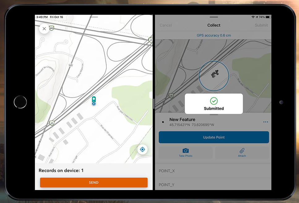
Eos Positioning Systems Inc. (Eos) has released capability in its Eos Tools Pro apps (iOS, Android, Windows) that allows Esri Collector for ArcGIS and Survey123 to run concurrently, allowing the user to dynamically switch between the two apps in the field.
“Without this capability, users could not run two data-collection apps, such as Collector and Survey123, or ArcGIS Field Maps and ArcGIS QuickCapture, at the same time,” Eos Chief Technology Officer Jean-Yves Lauture said. “With this release, parties can run multiple apps on a single device that simultaneously consume high-accuracy positioning data from the Arrow GNSS receiver.”
This new capability allows fieldworkers to run two apps at the same time while accessing the same ArcGIS Online database. Specifically, a user can now record a high-accuracy GNSS location in Collector and then immediately switch to an open Survey 123 form to complete their workflow. The data, including precise positioning will be populated to the same ArcGIS Online database.
“Eos is excited to enable its users with this unique capability to extend Esri mobile apps,” Lauture said. “Esri users have been asking us about combining Collector and Survey123 data collection for quite some time, and we are happy to further increase their high-accuracy data collection efficiency.”
My last column described a new National Geodetic Survey (NGS) webtool for obtaining geodetic information about a passive mark in their database. The column highlighted some features that may be of interest to GNSS users. It provides all of the information about a station in a more user-friendly format. This column highlights an ArcGIS web application that incorporates various California specific datasets and NGS data layers to assist surveyors planning vertical control surveys. The GNSS Leveling Web Application was provided to me by Jay Satalich, chief, Office of Surveys, Caltrans (see box titled “Linkedin Notification from Jay Satalich).
Linkedin Notification from Jay Satalich
Supervising Transportation Survey (Chief, Office of Surveys) at State of California, Department of Transportation:
“GNSS Leveling Web Application” [is] an Esri ArcGIS online web app created for my “GNSS Leveling” students at College of the Canyons. Designed as a practical tool when planning vertical control surveys using GNSS. National datasets include: National Spatial Reference System (layers: satellite visibility, stability, and vertical control source), geology, and GEOID18 (layers: GEOID18 height, difference between GEOID18 and GEOID12B, and GEOID18 uncertainty). California-specific datasets include: oil/gas/fracking/injection wells, fault lines, oil fields, groundwater basins, and landslide areas. The NOAA National Geodetic Survey data layers were created and published by Brian Shaw. People who influenced development of this app include Dave Zilkoski, Kevin M Kelly, Ken Hudnut, David D Jackson, Ross S. Stein, and Arthur Sylvester.
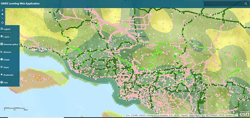
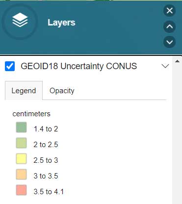
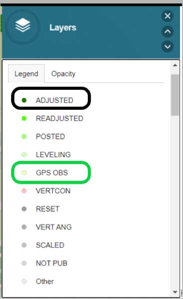
The box titled “GNSS Leveling Web Application” depicts a map of the Los Angeles area that provides the list of published marks in NGS’ database with an overlay of the uncertainty of NGS’ hybrid geoid model GEOID18. Plotting the published marks from NGS’ database is very useful for surveyors reconning marks for a GNSS survey project. The attributes allow users to quickly identify stations that have published heights from leveling adjustments projects (labeled as ADJUSTED) and those that have heights published from GNSS adjustments projects (labeled as GPS OBS). (See here for definition of attributes.)
Source: Esri ArcGIS GNSS Leveling Web ApplicationSource: Esri ArcGIS GNSS Leveling Web Application
Source: Esri ArcGIS GNSS Leveling Web Application
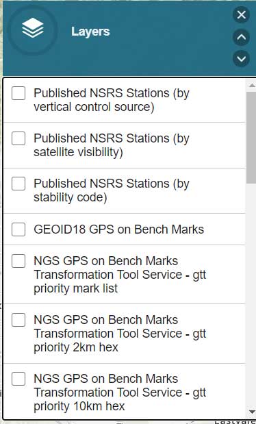
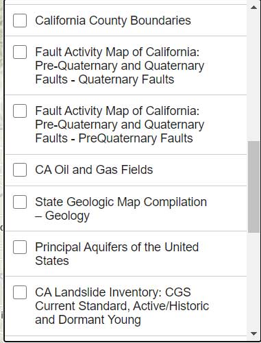
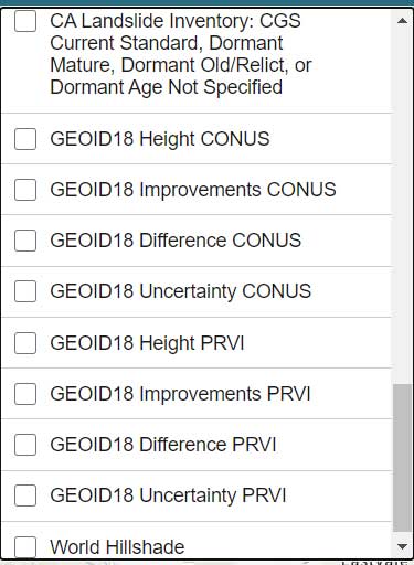
The list all of the layers of the web application are provided in the box titled “GNSS Leveling Web Application Layers.” (Note: After you open up the web application, click on the Layers icon to obtain the list of available layers.)
GNSS Leveling Web Application Layers
Source: Esri ArcGIS GNSS Leveling Web ApplicationSource: Esri ArcGIS GNSS Leveling Web ApplicationSource: Esri ArcGIS GNSS Leveling Web Application
Source: Esri ArcGIS GNSS Leveling Web Application
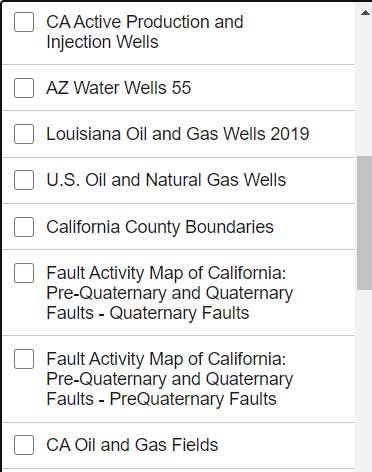
As you can see from the list of layers, the web application enables users to select the layers that are pertinent to their survey project requirements. The application is designed for California surveyors but the concept is transferable to other States. For example, the following layers are not just for California surveyors: Arizona water wells, Louisiana oil and gas well, U.S. oil and natural gas wells, Principal Aquifers of the United States, and, of course, all of the NOAA NGS data layers.
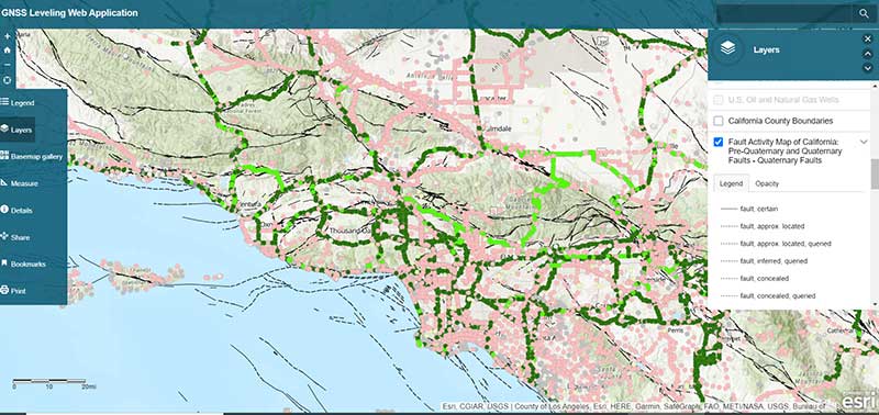
One layer that is very important to California users is the layer that provides the fault activity in their region. The box titled “Fault Activity Map of California: Pre-Quaternary and Quaternary Faults – Quaternary Faults” depicts the list of published marks in NGS’ database with an overlay of the fault activity map.
Fault Activity Map of California: Pre-Quaternary and Quaternary Faults — Quaternary Faults
Source: Esri ArcGIS GNSS Leveling Web Application
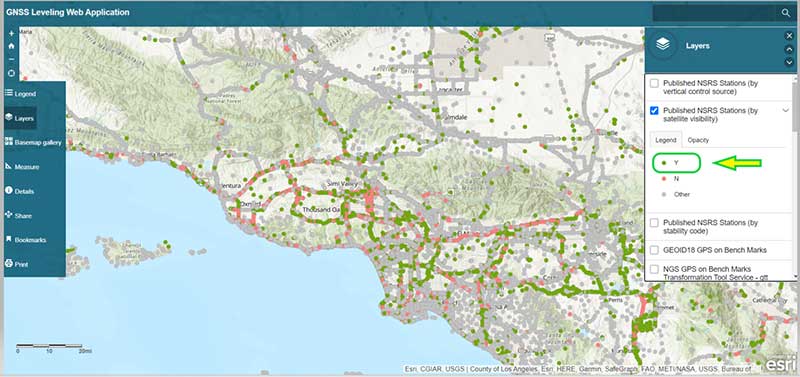
Another great feature of the application is that it has a layer providing the satellite visibility code for published NSRS marks (see the box titled “Published NSRS Stations (by satellite visibility”). Once again, a great feature for field personnel performing reconnaissance.
Published NSRS Stations (by satellite visibility)
Source: Esri ArcGIS GNSS Leveling Web Application
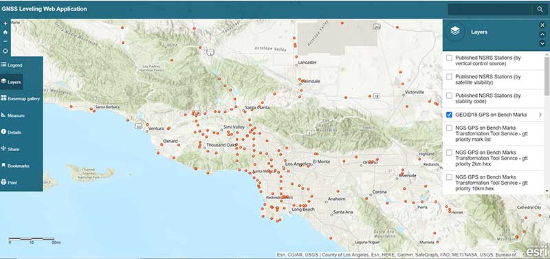
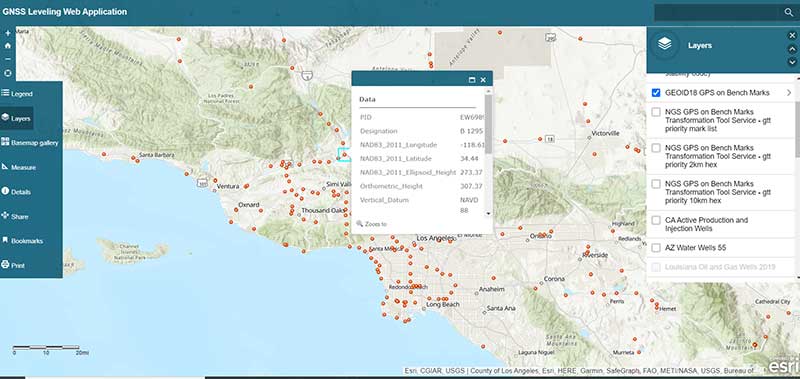
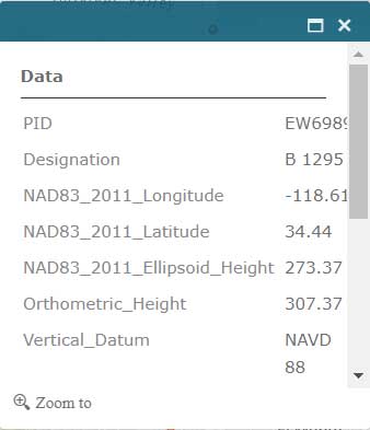
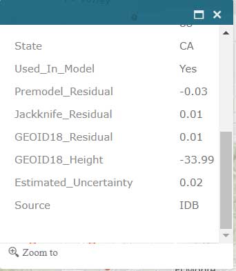
The application also has a feature that lists the marks that were involved in the development of NGS’ hybrid geoid model GEOID18. (see the box titled “GNSS Leveling Web Application GEOID18 GPS on Bench Mark Layer”). Clicking on a mark’s icon provides information and statistics about the mark (see boxes titled “GEOID18 GPS on Bench Mark Layer — PID EW6989” and “Information for GPS on Bench Mark for PID EW6989”). This is one of the layers that provides information for the entire CONUS region. All this information is available from NGS’ website but this application incorporates all of NGS’s data as well as the local information in one application. This web application is very useful to a surveyor planning a survey project and/or providing information to a field reconnaissance team.
GNSS Leveling Web Application GEOID18 GPS on Bench Mark Layer
Source: Esri ArcGIS GNSS Leveling Web Application
GEOID18 GPS on Bench Mark Layer — PID EW6989
Source: Esri ArcGIS GNSS Leveling Web Application
Information for GPS on Bench Mark for PID EW6989
Source: Esri ArcGIS GNSS Leveling Web Application
Source: Esri ArcGIS GNSS Leveling Web Application
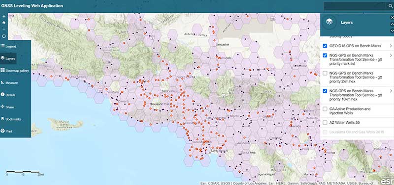
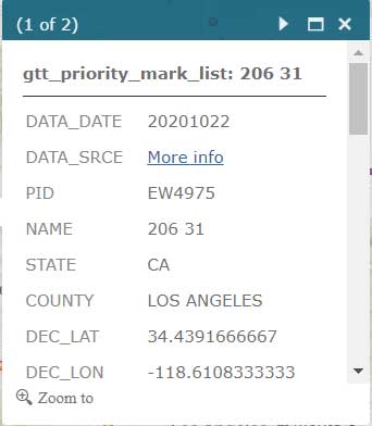
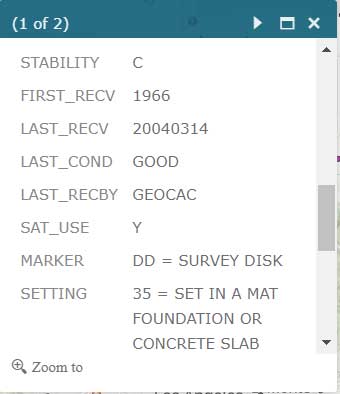
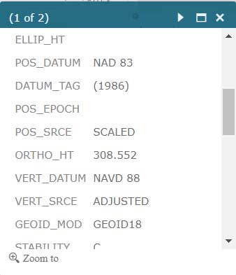
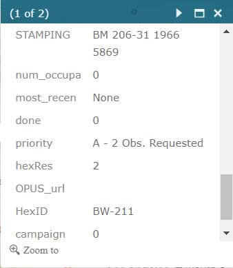
Users that are participating in NGS’ GPS on Bench Mark program can click on the layer for “NGS GPS on Bench Marks Transformation Service Tool, priority 10 km hex” to determine marks that need to be occupied by GNSS to improve a transformation tool being developed by NGS. See boxes titled “NGS GPS on Bench Marks Transformation Service Tool, priority 10 km hex” and “Information for GPS on Bench Mark Priority List for PID EW6989.” There’s also layers that depict the priority mark list for the GPS on Bench Marks program (“NGS GPS on Bench Marks Transformation Tool Service — priority mark list”) and the 2 km hexagon priority grid (“NGS GPS on Bench Marks Transformation Tool Service — priority 2km hex”).
NGS GPS on Bench Marks Transformation Service Tool, priority 10 km hex
Source: Esri ArcGIS GNSS Leveling Web Application
Information for GPS on Bench Mark Priority List for PID EW6989
Source: Esri ArcGIS GNSS Leveling Web ApplicationSource: Esri ArcGIS GNSS Leveling Web ApplicationSource: Esri ArcGIS GNSS Leveling Web Application
Source: Esri ArcGIS GNSS Leveling Web Application
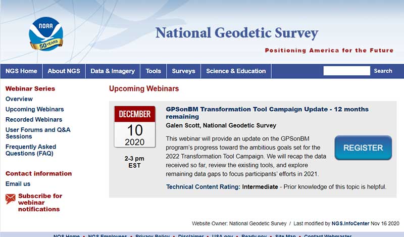
Individuals interested in participating in NGS’ GPS on Bench Mark program should register for NGS’ Dec. 10 webinar, which will discuss the status of the program. See the box titled “GPSonBM Transformation Tool Campaign Update — 12 months remaining” for the information on the webinar. Users can register for the webinar here. I would encourage all users to access the web application tool developed by Jay and/or NGS’ website before participating in the next NGS GPS on Bench Mark webinar.
Almost all of my columns have focused on establishing accurate GNSS heights. Most of my 45 years of working in the field of geodesy has been focused on heights; that is, leveling-derived orthometric heights, GNSS-derived orthometric heights, and geoid heights. Gravity is very important to estimating all of these types of heights. Recently, a colleague sent me a video proving Galileo’s famous gravity experiment. It’s an older video (November 2014), but it’s really fascinating. You can see the entire video here. Another individual pointed me toward the same experiment performed on the Moon during the Apollo 15 mission. What’s amazing to me is that over 400 years ago an individual spent time studying the effects of gravity and developing the concept of acceleration due to gravity. I wonder what the world would look like today if Galileo would have just accepted Aristotle’s theory of gravity (which states that objects fall at speed proportional to their mass) and decided to focus on other tasks. Saying that, I am amazed that most geospatial users do not realize the importance of gravity (and physical geodesy) in the development of the geospatial products and services that they use daily; and, how critical it is that more research is required to meet future geospatial needs. The advancements in satellites and computers have enabled geodesy to expand into many different disciplines. Geodetic science and technology now underpin many sciences, large areas of engineering (such as driverless vehicles and drones), navigation, precision agriculture, smart cities, cellular telephones, and location-based services. (See the GPS World First Fix column about the shortage of American geodesists).
When I end one of my presentations, I always emphasize that Geodesy Provides the Foundation for all Geospatial Products and Services, and Integrated and Collaborative Organizations Create Geospatial Solutions. Geodesy is just as important today as it was 400 years ago.
I hope everyone stays safe during this COVID-19 pandemic and enjoys the holidays.
The OxTS Georeferencer combines INS and point-cloud data from third-party lidar sensors. (Image: OxTS)
OxTS is offering its new OxTS Georeferencer, a powerful lidar georeferencing software tool. OxTS Georeferencer combines OxTS inertial navigation data with raw lidar data to give surveyors the ability to create georeferenced point clouds along with tools to calibrate their setup and analyze the accuracy of their surveys.
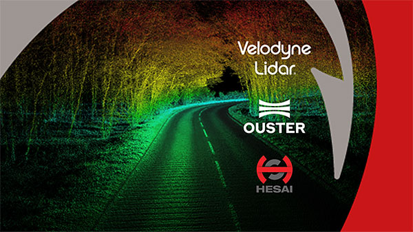
Users can now combine data from their OxTS inertial navigation system (INS) with a much broader range of lidar sensors. The OxTS Georeferencer works with pointclouds from Hesai, Ouster and Velodyne lidar sensors. New sensors brought to market can be quickly and easily added to OxTS Georeferencer.
This release ensures that surveyors can easily and confidently use OxTS Inertial Navigation Systems and OxTS Georeferencer, to produce georeferenced point clouds irrespective of the LiDAR scanner they prefer to use.
The OxTS Georeferencer gives surveyors flexibility in terms of the hardware they may use to survey their environment.
Users can combine OxTS INS data with data from the following models:
Velodyne. VLP-16 Puck, Puck LITE (beta), VLP-32C (beta) and Alpha Prime VLS128 (beta). The Velodyne VLP-32C sensor is single-return mode only.
Hesai. Pandar40P
Ouster. All Ouster Gen2 lidar, The OS1 and OS2 lidar with 32, 64 and 128 lasers (all Ouster integrations, other than the OS1-64 in uniform laser distribution, are in beta.)
Features of this release include:
Improved calibration. Take advantage of a broader range of set-ups without extensive planning and set-up costs. A data-driven calibration technique helps to get the best results from your set-up. It eliminates blurring and double-vision, especially at longer distances. The new version now can calibrate angles AND linear displacements. Please note that LIP calibration is in beta.
Error estimation. Gain more control over your point-cloud. The new pointcloud error estimation uses a sophisticated formula together with OxTS navigation data diagnostics. These are then used to estimate the centimetre uncertainty in point positions. Users can then choose a maximum uncertainty to be included or remove inaccurate points.
Dual return. Provide customers with enhanced point-cloud images. The new version of OxTS Georeferencer includes dual return capability for nearly all supported models. Where available, this will give point clouds much higher definition. Users can then present enhanced point-cloud images to customers and internal stakeholders as well as service specific applications.
Easily integration of new lidar families. This latest version of OxTS Georeferencer supports the future proofing of other new LiDAR sensors. It allows users to quickly and simply add new LiDAR families to the framework. If there are any LiDAR sensors NOT currently integrated that you want to see, contact OxTS and they will consider them.
For more information on OxTS Georeferencer or to arrange a demonstration, contact OxTS – OxTS Georeferencer.