
Category: Applications

  • UC Denver to establish Trimble lab for College of Engineering, Design and Computing

    UC Denver to establish Trimble lab for College of Engineering, Design and Computing

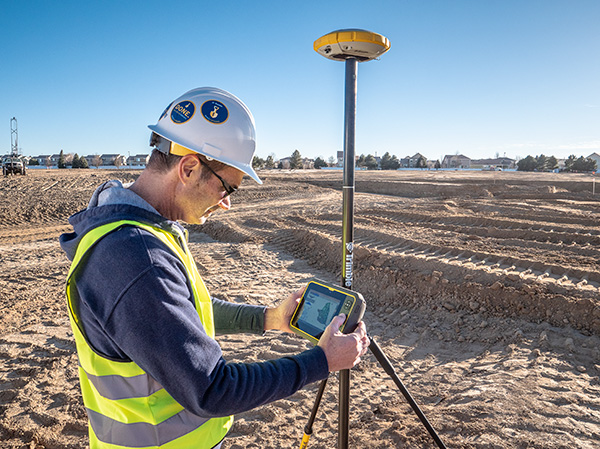
    Photo: Trimble
    Photo: Trimble

    The University of Colorado – Denver has received a significant gift from Trimble to establish a state-of-the-art technology lab for the College of Engineering, Design and Computing.

    The gift will also support the departments or programs in construction engineering and construction management, geography and environmental sciences, physics, and urban and regional planning. The lab will expand the university’s access and expertise in a customized suite of construction hardware and software products.

    Trimble’s broad Connected Construction portfolio enables professionals along the project lifecycle to accelerate project processes — improving productivity, quality, transparency, safety and sustainability, while reducing waste.

    The Trimble Technology Lab will provide students enrolled across relevant programs hands-on experience with a wide breadth of Trimble solutions. The lab will expand the university’s access and expertise in project management, architectural and structural analysis, design and engineering, mixed reality, 3D scanning, office-to-field solutions, and GIS data collection and GNSS positioning.

    Partnering with Trimble allows the University of Colorado – Denver to integrate the latest technology into its curricula, empowering graduates to rapidly transform how buildings and living environments are designed and constructed.

    The lab will include a broad range of Trimble’s technologies.

    • Hardware includes the Trimble XR10 HoloLens with hardhat, TX8 3D laser scanner, Trimble SiteVision AR system, R12 GNSS systems, Juno 5D handheld scanner, Geo 7x mobile GNSS data collectors, robotic total stations and field tablets.
    • Software solutions include RealWorks scanning software, Trimble Business Center, Tekla Structures, Tekla Structural Designer, Tekla Tedds, Trimble Connect, ProjectSight, Viewpoint, TILOS, Trimble Positions Desktop, TerraSync and TerraFlex, eCognition, and the company’s 3D modeling software, SketchUp Pro.

    “CU Denver is right in our backyard, providing an exciting opportunity to integrate our industry-leading technologies into a wide range of educational programs. Their proximity enables us to work closely while ensuring easy access, training and support, and success in all aspects of implementation,” said Allyson McDuffie, director of Education & Outreach at Trimble. “Trimble’s education and outreach programs aim to support the next generation of influencers by actively working with key education institutions to ensure Trimble’s portfolio of solutions are accessible and implemented in higher education curricula and research programs, creating a new workforce equipped and empowered to ‘Transform the Way the World Works.’”

    Martin Dunn, dean of the College of Engineering, Design and Computing, said, “I am thrilled with and grateful for this exciting relationship with Trimble. It will accelerate our strategic vision to educate diverse graduates who will not only make an immediate impact in the AEC industry, but will emerge as its future leaders. The generous gift will have broad impact across our campus, nucleating the kind of interdisciplinary collaboration among engineers, architects, construction managers, and scientists that is needed to create and exploit technological innovation to address grand challenges facing the built environment including digital transformation, sustainability, and the future of work and the workforce.”

    “Our students and faculty could not be more excited to have access to Trimble technologies. Trimble is a company of international importance, which is also right down the road from our campus. In establishing this new lab, our students will be exposed, either virtually or on-site, to cutting edge products and innovation as well as benefit from direct access to the many professionals in Trimble’s worldwide network. Trimble is exactly the type of company that gets our students excited about pursuing careers in construction and engineering,” said Caroline Clevenger, associate professor and director of Construction Engineering and Management.

  • Route Masters to build integrated public transport platform for African megacities

    Route Masters to build integrated public transport platform for African megacities

    Photo: peeterv/iStock/Getty Images Plus/Getty Images
    Photo: peeterv/iStock/Getty Images Plus/Getty Images

    Route Masters signed up to U.K. program SPRINT to develop an innovative transport management solution for African cities

    Route Masters, based at the European Space Agency BIC UK in Harwell in Oxfordshire, has signed up to the national SPRINT (SPace Research and Innovation Network for Technology) business support program to develop an innovative transport management solution for African cities.

    Funding from SPRINT will enable Route Masters to collaborate with the University of Leicester on building a full suite of technology tools and algorithmic data models. This will help the company to achieve its aim of becoming the largest integrated public-transport platform for emerging African megacities.

    Route Masters is developing an algorithm based on single-band GNSS positioning within cities. The solution will deliver transport flow models superimposed on satellite-based city maps. The technology utilizes applied mathematics to build digital route maps that will accurately deliver journey times and modes for city planning tools and mobile navigation applications for consumers.

    This data fusion project will combine dual-band GNSS with single-band GNSS and satellite derived city maps. The solution will be leveraged to deliver planning and control intelligence services and consumer services and, after University of Leicester validation, it will be tested and deployed as an active prototype in Lagos, Nigeria.

    The University of Leicester will provide Route Masters with expertise in algorithms and software development for data driven space projects as well as high-performance computational (HPC) facilities.

    The project will be funded by a grant from the £4.8 million SPRINT programme that provides unprecedented access to university space expertise and facilities. SPRINT helps businesses through the commercial exploitation of space data and technologies.

    “We’re a highly ambitious sustainable business with the goal of creating the largest technology-enabled data platform for transport on the African continent,” Meir Wachs, CEO of Route Masters, said. “The support of SPRINT will enable us to develop our technology in specific areas, working with the Leicester mathematics school to accelerate our development in certain key areas and to build a robust and rigorous solution that can make an actual impact on the world.”

    “Projects such as this SPRINT one with Route Masters are of great benefit to the university as they enable us to engage with vibrant companies and transfer our knowledge into commercial innovative applications,” added Alberto Paganini, Lecturer in Applied Mathematics at the University of Leicester.

    “We’re bringing advanced mathematical methods, data analysis and software development to the project, not only supporting the commercial development of Route Masters’ technology but also allowing us to integrate the insight gained into our curriculum to further enhance the employability skills of our students.”

    Muyiwa Omopariola, Lead Transport Analyst at the Lagos Metropolitan Area Transport Authority (LAMATA) also expressed his support for the project, noting, “I greatly support technology innovation in the transport sector, especially in Lagos and across the emerging world. We look forward to seeing their continued progress.”

  • HERE integrates what3words into in-car navigation feature

    HERE integrates what3words into in-car navigation feature

    Drivers will now be able to enter what3words addresses directly into their in-car systems, allowing them to navigate to any destination

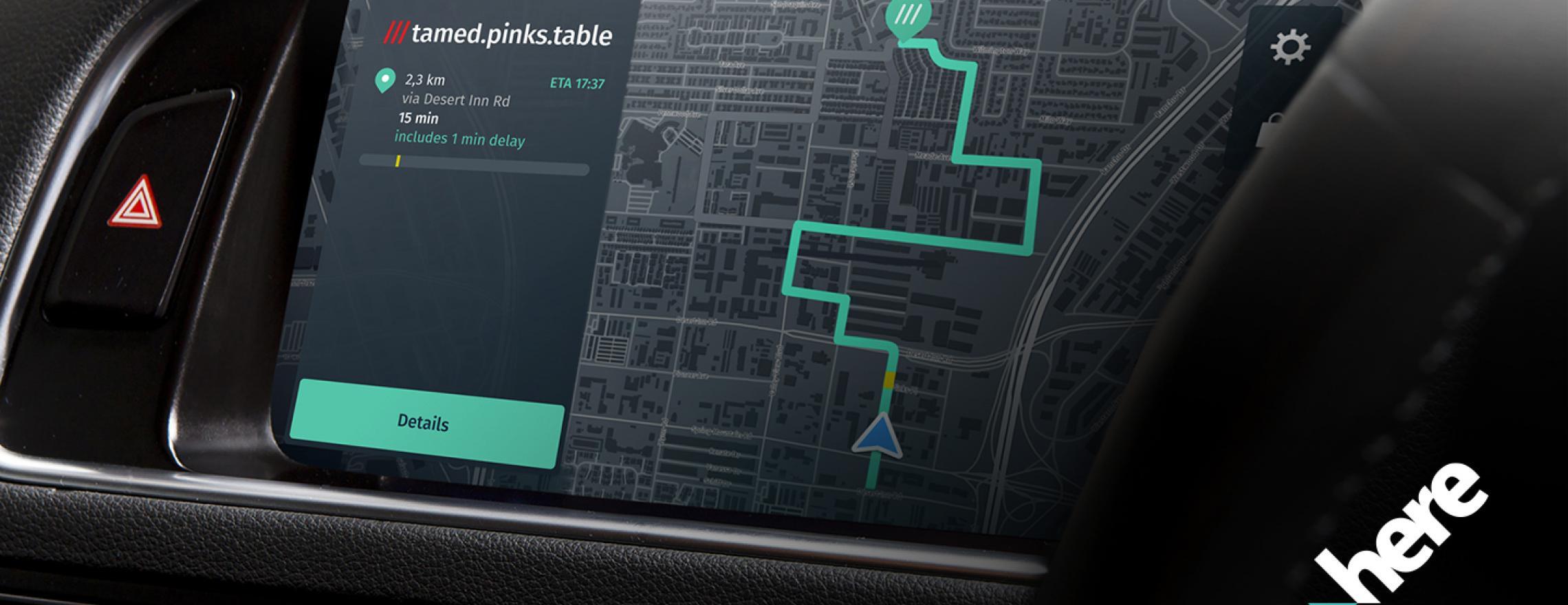
    Image: HERE
    Image: HERE

    HERE and what3words have partnered up to offer the next generation of precision in-car navigation. OEMs using HERE Technologies can now include what3words as an in-car navigation feature, with drivers of enabled vehicles able to navigate to any precise 3-meter square using a what3words address.

    HERE is the world’s leading navigation platform with its map data services found in 150 million vehicles worldwide. The platform offers products designed to use the latest location content, such as road networks, buildings and traffic systems. The addition of what3words address entry means that drivers can experience the smartest mapping systems, alongside the break-through address system.

    what3words is an innovative addressing system which has divided the world into a grid of 3-meter squares and given each square a unique combination of three words: a what3words address. For example, HERE’s Chicago office can be found at ///memory.traps.lease. what3words enables people to easily convey locations as specific as building entrances or parking spots and it provides easy location references in places with no street addresses, such as beaches, parks and remote hiking trails.

    Drivers can input a what3words address directly into their car head unit or connected car app, just as they would a street address or point of interest. Millions of what3words addresses are being used over the world, with drivers finding them in booking confirmations, guidebooks, website contact pages or in messages sent by friends.

    Drivers can also discover what3words addresses on the free what3words app or the online map. what3words’ technology has been adopted by global car companies, logistics providers and mobility apps, including Mercedes-Benz, Tata Motors, DB Schenker, Hermes and Cabify.

    “HERE is the richest, most accurate and freshest mapping system on the market and it now comes with the easiest way to communicate a location,” Chris Sheldrick, CEO and co-founder of what3words said. “Using a traditional address in a vehicle can be a bad experience. They are clunky and lengthy to type, and even a voice assistant will often mishear you. Once the address is accepted, it won’t take you to a precise location, such as the specific entrance you need, it’ll route you to where the pin drops — which is often the centre of the building.

    By using what3words, drivers need simply to enter three words and know they will arrive at that precise 3-metre square. We are seeing increasing demand from automakers and mobility services. Now that we are embedded in HERE, we can enable our address system simply and easily in both new and legacy vehicles.”

    “Our partnership with what3words is a solid example of how HERE continues to innovate in the area of navigation,” said Jørgen Behrens, senior vice president and chief product officer at HERE Technologies. “Automotive OEMs and Tier 1 suppliers can now provide the what3words service to their customers with the help of HERE Professional Services instead of having to integrate it themselves. This will allow drivers to navigate easily in dense, urban environments with non-standard addressing schemes or seamlessly get to any location, be it a local pub or a trailhead.”

    Incorporating this new feature is easily done for both new and existing clients, with what3words available as an add-on to HERE’s core navigation products.

  • USDOT to host GPS jamming workshop Dec. 3

    USDOT to host GPS jamming workshop Dec. 3

    The U.S. Department of Transportation is sponsoring an afternoon workshop “GPS Jamming and Spoofing in the Maritime Environment” on Dec. 3.

    Speakers include Diana Furchtgott-Roth Deputy Assistant Secretary for Research and Technology; ship captains from Maersk Lines; and representatives from the National Security Council, the Maritime Administration and U.S. Coast Guard.

    While GPS jamming and spoofing is a problem in many transportation and critical infrastructure sectors, it is often most visible in maritime. This is because the Automatic Identification System (AIS) used for collision avoidance and traffic management for major vessels transmits location data based on GPS inputs.

    These transmissions are received by coastal networks and satellite systems. AIS data is often freely available to the public or easily accessed.

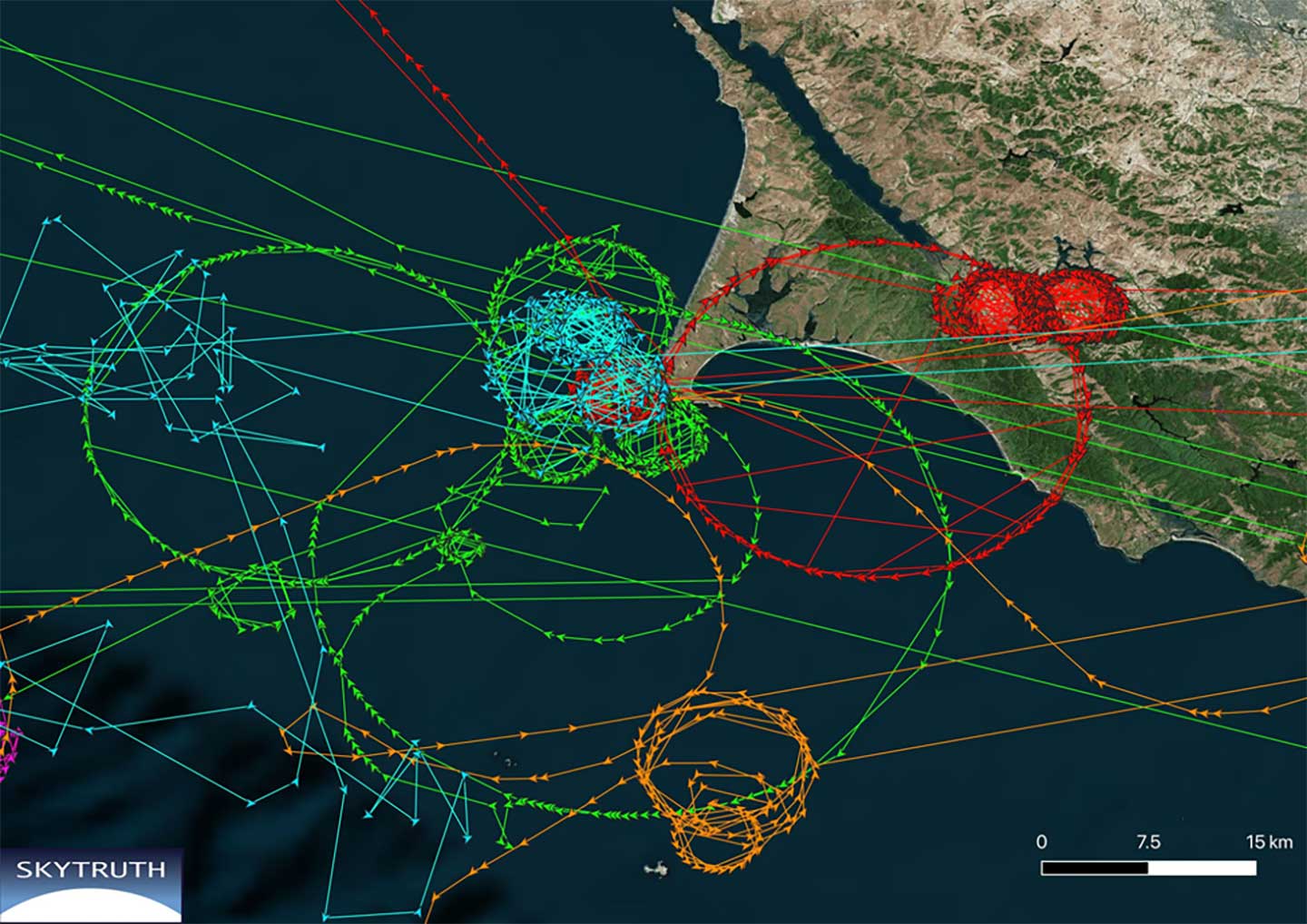
    Ships in Russian waters being spoofed to inland airports, vessels in Chinese ports reporting they are inland and circling government buildings, and ships in one part of the world transmitting their location as thousands of miles away and circling in the ocean off northern California are three of the highest provide examples in recent years.

    In 2019, the U.S. Coast Guard brought interference with GPS signals as an “urgent issue” to the International Maritime Organization.

    In February, President Trump issued an Executive Order on responsible use of positioning, navigation and timing. This workshop is part of the federal government’s efforts, as a part of the order, to educate the public about vulnerabilities associated with over-reliance on GPA.

    The workshop is free, but attendees must register. Advance registration is available.

    Image courtesy of Skytruth and RNTF.
    Image courtesy of Skytruth and RNTF
  • Bluesky launches online streaming service for panoramic aerial images

    Bluesky launches online streaming service for panoramic aerial images

    The Bluesky MetroVista range includes high-resolution imagery combined with high-accuracy, wide-scale 3D models. (Image: Bluesky)
    The Bluesky MetroVista range includes high-resolution imagery combined with high-accuracy, wide-scale 3D models. (Image: Bluesky)

    Aerial mapping company Bluesky is releasing its entire catalog of geographically referenced oblique aerial images of cities in the United Kingdom (UK) via a new subscription-based streaming service.

    Working with Geoxphere, a specialist in cloud-based GIS, Bluesky will offer MetroVista imagery via an easy-to-use web viewer that also includes measurement tools for detailed analysis of building features, façade details and street furniture locations.

    “Oblique imagery offers an unparalleled view of the built environment revealing real world features simply not present in any other type of aerial image or map,” commented Rachel Tidmarsh, managing director of Leicestershire-based Bluesky International. “The MetroVista imagery can be used to inform decision making with time stamped intelligence, and even evidence, as well as improving engagement with colleagues through better communication of ideas. All of this without even leaving your desk!

    “However this wealth of information, as you would expect, can present some issues when it comes to storing and consuming data. The MetroVista Oblique Viewer overcomes these issues meaning the value of the data can be realised without the burden of storing, processing or updating.”

    With a data-as-a-service (DaaS) solution powered by Geoxphere’s XMAP geospatial cloud technology, the MetroVista Oblique Viewer is a fully managed subscription service meaning there is no need to download or store large volumes of data locally. The MetroVista Oblique Viewer does not require any specialist software, plugins or downloads and, as the data is also managed, newly captured images are automatically added to an account as they become available.

    The MetroVista Oblique Viewer has split screen options and rotating views allowing the user to toggle through images to get a 360 degree view of a building. The Bluesky Geoxphere Viewer also includes height and area measurement tools for recording a building height or distance from a feature and its façade area.

    Captured using the world’s first large format imagery and lidar hybrid airborne sensor, Bluesky MetroVista imagery collection includes simultaneously captured oblique and vertical aerial photography. The MetroVista datasets also include geographically accurate, photo-textured, mesh models ready for use in 3D GIS, CAD and other modelling software as well as visualisation, gaming and Virtual Reality workflows.

    Bluesky has already captured MetroVista data for cities such as London, Birmingham, Manchester, Bristol, Nottingham, Oxford, Cambridge, Brighton, Norwich, Leicester, Derby and Newcastle as well as Bournemouth, Brighton, Cardiff, Doncaster, Eastbourne and Southend.

  • Topcon GNSS to assist Bridges to Prosperity efforts in Africa

    Topcon GNSS to assist Bridges to Prosperity efforts in Africa

    A shipping container with several pieces of key GNSS and survey instrumentation is bound for the East African country of Rwanda. The equipment, an in-kind donation from Topcon Positioning Group, will be used in support of Bridges to Prosperity (B2P), an organization committed to building trail bridges to improve the lives of people in rural areas worldwide.

    Photo: Bridges to Prosperity
    Photo: Bridges to Prosperity

    According to B2P, almost a billion people around the world lack safe access to critical resources like healthcare, education, or employment due to an impassable river. Building safe, structurally sound trail bridges for people to travel by foot, bicycle, or motorcycle has an immediate, impactful effect on the lives of those in the area.

    “We are fortunate that, even with challenges presented by the COVID-19 pandemic, we have been able to implement new safety measures with limited disruption to our building schedule,” said Devin Connell, B2P’s corporate program director. “Right now, our surveying efforts predominantly involve simple equipment such as auto levels and range finders, which can be time consuming when complex survey information is needed. The equipment from Topcon will increase our surveying capabilities, streamline the design process, and support us in building more trail bridges for isolated communities.”

    Photo: Bridges to Prosperity
    Photo: Bridges to Prosperity

    In addition to the instruments — a pair of GNSS receivers, two total stations and data collectors — B2P will have access to the Topcon suite of software products, which will assist both the design process and the transfer of files from the field to their remote office or the engineering team working with them. According to Ron Oberlander, vice president of Topcon Global Professional Services group, however, the company’s role extends well past the equipment itself.

    “We are excited to be a contributing part of this program,” he said. “But, in order for B2P to use these solutions to their fullest and increase their overall productivity, a training effort will be needed and we’re already setting plans in place for that to happen.

    “In addition to conducting online virtual training sessions with B2P staff, we are making eLearning possible by allowing access to MyTopcon, our company knowledge portal. With these tools, they can gain familiarity with their receiver or total station or use the Topcon software to learn how to collect points — all without having us there. They want to be able to hit the ground running once the equipment arrives and this will help make that happen.”

    Connell said that their improved survey capability will help accelerate the company’s bridge building. “We go out and survey a year in advance, looking at as many as 100 different remote sites and, tough as it might be, establish priorities with the local governments. We are looking forward to our continued growth in 2021 and, thanks to the generosity of companies like Topcon, that process will be a much better one.”

  • Alstom pioneers use of Galileo to help measure location and speed of trains

    Alstom pioneers use of Galileo to help measure location and speed of trains

    Photo: Alstrom
    Photo: Alstrom

    News from the European GNSS Agency

    In June, Alstom became the first railway manufacturer to integrate certified data-fusion algorithms for fail-safe train localization, using position and speed of trains based on GNSS data coming from multiple constellations, including Galileo.

    The added value of Galileo and EGNOS in the European railway sector is widely known, especially when it comes to non-safety applications, such asset management and passenger information services.

    In recent years, however, with multi-constellation becoming the norm and multifrequency receivers being adopted rapidly, rail stakeholders view GNSS-based solutions as game-changers for the future of European Train Control System (ETCS).

    A recent example of EGNSS adoption in rail operations is the innovative odometry solution deployed by Alstom to measure the location and speed of its trains. The French rolling-stock manufacturer introduced a new sensor type, with a hybridisation of satellite information and inertial sensors. The solution is primarily using GNSS Doppler information, derived from Galileo, GPS and GLONASS constellations (configurable).

    Such use allows to improve the overall confidence in the resulting speed, along with specific algorithms to master the resulting location accuracy. The GNSS receiver is an automotive grade receiver manufactured by u-blox. The inertial measurement unit (IMU) used to supplement information in case of GNSS loss is based on enhanced micro-electromechanical systems (MEMS) technology, with temperature compensation.

    The new odometry system based on data fusion, which Alstom is currently implementing in Norway, is applicable to all types of trains and all environments, including the harshest weather conditions. It is estimated that by 2026, 450 trains will be equipped with this new feature across Norway.

    Increased safety, lower costs for rail companies

    Wheel slipping and sliding especially during demanding weather conditions can affect the odometer accuracy and the proper functioning of the different sensors involved. By incorporating Galileo signals as an extra layer of accuracy, Alstom managed to create a system that is capable of providing a more robust speed and location estimate. This space data fusion approach —certified by Belgorail — minimizes the need for the costly external radar components for localisation and speed measurement currently used.

    “Industry embedding Galileo in their solutions is the proof that we are on the right path to ensure the market uptake of the EU Space Programme technology,” said Rodrigo da Costa, GSA executive director. “This is a recognition of the capability of EGNSS to reduce the need for infrastructure and related cost, while maintaining the operational safety of ETCS.”

  • GSA, Public Safety sign BroadGNSS agreement on critical infrastructure

    GSA, Public Safety sign BroadGNSS agreement on critical infrastructure

    Agencies plans commercial procurement of innovative solutions

    BroadGNSSThe European GNSS Agency (GSA) is joining with Public Safety Communication Europe (PSCE) to coordinate the BroadGNSS Pre-Commercial Procurement (PCP) program.

    BroadGNSS will procure innovative solutions for applications, synchronization and monitoring of critical mobile broadband communication infrastructure and information assets for public protection and disaster recovery (PPDR) Operations.

    The project brings together three members of a joint procurement team:

    • French Ministry of Interior (lead procurer)
    • Estonian Infocommunication Foundation
    • Finnish Erillisverkot

    The team will be supported by PSCE and Austrian GNSS company OHB Digital.

    The agreement provides for a total budget of €3.6 million over 40 months, beginning this Dec. 1. Of that, €2.5 million is reserved for pre-commercial procurement of innovation solutions. This budget will be made available to industry following an open and competitive process.

    BroadGNSS will seek innovative solutions to apply European GNSS to further improve the overall capability of trustworthy information exchange, enabled by new broadband mobile communication.

    BroadGNSS will consult key government stakeholders across Europe to scope the specific objectives of the PCP procurement. A “prior information notice” will be released to initiate consultation with innovative industry to contribute their knowledge and capabilities to help our team to prepare a formal request for tender to be released later next year.

    BroadGNSS will build upon the success of the BroadWay PCP, which is currently in the prototyping phase. Three innovative prototypes are now in development to address the challenge to enable a pan-European mobile broadband system for PPDR. Prototypes will be evaluated in April 2021, with interim demonstrations to the BroadWay group of procurers this month (November). These prototypes are developed under the leadership of key industry heavyweights, Airbus, Frequentis and Leonardo.

    The combination of the results of BroadWay and BroadGNSS will contribute to provide improved mission critical services to public safety responders.

    Details of the Pre-Commercial Procurement process can be found on the European Commission website. For up to date information on BroadGNSS events, go to www.broadgnss-info.eu.

  • Editorial Advisory Board PNT Q&A: Advancing bathymetry

    Editorial Advisory Board PNT Q&A: Advancing bathymetry

    Which recent GNSS/INS innovations have been most helpful in advancing bathymetry? Which upcoming ones will be?

    Headshot: Miguel Amor
    Miguel Amor

    “Development of PPP removed reliance on shore-based RTK base stations, allowing operation almost anywhere on the oceans. Continued performance improvement in FOG and MEMS INS, along with bathymetric sensors, provide cost-effective solutions while also providing more accurate seabed maps. The future will see increased PPP accuracy with faster convergence and continued improvement in INS, coupled with increased resolution of bathymetric sensors, leading to more of the oceans mapped using autonomous platforms.”
    Miguel Amor, 
    Hexagon Positioning


    Bernard Gruber
    Bernard Gruber

    “While GNSS has been a clear contributor to Earth mapping, it is an altogether different dilemma to solve ‘submarine topography’ mapping. Given recent developments in the IMU and lidar markets, one can readily utilize these sensors to correct for roll, pitch, and yaw, and produce digital maps, respectively. Combining these sensors with GNSS receivers, mounted on a drone for example, can allow for precise measurements in areas of tidal shifts or dynamic variations of water depth.”
    Bernard Gruber,
    Northrop Grumman

  • Hexagon’s ‘RTK from the Sky’ brings instant GNSS accuracy worldwide

    Hexagon’s ‘RTK from the Sky’ brings instant GNSS accuracy worldwide

    New service provides PPP convergence for centimeter-level accuracy on land, air and marine applications around the world

    Research from Hexagon’s Autonomy & Positioning division has resulted in breakthrough innovations in precise point positioning (PPP) that enable nearly instant global centimeter-level accuracy. These developments pave the way to bring “RTK from the Sky” performance to worldwide users through correction service products and GNSS receivers from Hexagon.

    RTK from the Sky technology provides the quick accuracy of an RTK solution with the high accessibility and availability of PPP. Users will no longer have geographic or regional infrastructure restrictions — they will be free to operate anywhere around the world with the same premium level of positioning performance.

    RTK from the Sky technology removes the traditional PPP barrier of long convergence times as well as internet and radio communication limitations, delivering instantaneous convergence anywhere in the world. This breakthrough establishes the foundation for assured positioning with no downtime in marine, agriculture, and autonomous applications.

    To achieve these results, there must be masterful attention to detail throughout the entire positioning ecosystem: no errors conveniently cancelled and no errors ignored. All errors are carefully estimated and removed from the final GNSS position faster and more reliably than ever before.

    This end-to-end fine-tuning of measurement quality and error mitigation establishes the foundation for RTK from the Sky performance. No matter the location or application, users will be able to rely upon the highest availability and accuracy of corrections anywhere in the world, without the convergence time, Hexagon said.

    “In 2020, PPP has become RTK — without the mobility limitations,” said Sandy Kennedy, VP of Innovation at Hexagon’s Autonomy & Positioning division. “RTK from the Sky has been a very satisfying development. To see this kind of positioning performance available anywhere in the world is the realization of the next step of innovation for GNSS.”

    RTK from the Sky technology will be the foundation for future correction service products and applications from Hexagon built for diverse applications.

    See a white paper on RTK from the Sky.


    Feature photo: Nikada/E+/Getty Images

  • Belgian company Seafar pioneers barge automation technology

    Belgian company Seafar pioneers barge automation technology

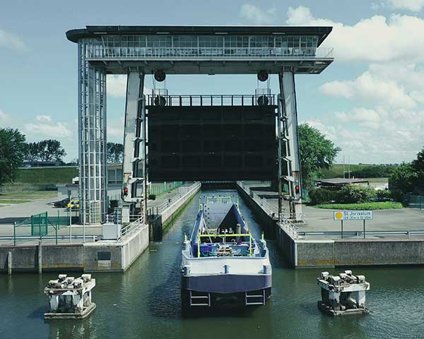
    An autonomous freight barge moves through a lock. The barge is equipped with Septentrio GNSS positioning via Seafar navigation. (Photo: Seafar)
    An autonomous freight barge moves through a lock. The barge is equipped with Septentrio GNSS positioning via Seafar navigation. (Photo: Seafar)

    Seafar has integrated Septentrio’s AsteRx-U dual-antenna, multi-frequency, multi-constellation receivers into its autonomous vessels to provide sub-meter positioning for navigation and control.

    AsteRx-U’s robust enclosure is equipped for harsh outdoor marine environments. The dual-antenna set-up provides precise heading information along with reliable positioning. A captain in a Remote Operating Center monitors several unmanned ships simultaneously, and can take over navigation control if the need arises.

    The maritime industry is witnessing an emerging trend of navigation automation both in the open sea as well as inland. Lloyds Register predicts that the marine industry will undergo a shift toward full autonomy for seafaring as well as inland ships by 2035, a timeline similar to that of the automotive industry.

    And GNSS positioning plays a key role. Unlike open sea transport, inland barges navigate narrow waterways, passing through locks, under bridges and near urban areas. The distance between ships can be down to 1 meter in a tight lock. Septentrio’s AsteRx-U provides the accurate and continuous positioning that enables ships to navigate in ports, stay on their predetermined routes and dock at harbors. The receiver also provides Septentrio’s Advanced Interference Mitigation (AIM+) to ensure reliable positioning in the face of jamming or spoofing.

    Currently, only 6% of inland transport travels on waterways, though water transport is more energy efficient and safer than rail and road. Optimized route and fuel efficiency, increased cargo space and savings on human resources are ways automation helps inland barge owners increase their margins and gain a competitive edge.

  • Cobham to supply anti-jam GPS solution for US Army UAS

    Cobham to supply anti-jam GPS solution for US Army UAS

    Logo: Cobham

    Cobham Aerospace Connectivity has been selected by General Atomics Aeronautical Systems Inc. (GA-ASI) and the U.S. Army to provide the anti-jam GPS systems for the MQ-1C ER Gray Eagle Extended Range (GE-ER) unmanned aircraft system (UAS) platform.

    As part of a multi-domain operation equipment suite that is compatible with existing GE-ER aircraft, the DACU-8 capability provides assured positioning, navigation and timing to the Gray Eagle ER UAS, weapons and sensors. According to Cobham, this modification to the Gray Eagle ER UAS ensures the platform can provide reconnaissance, surveillance and target acquisition and attack capability, even in a GPS contested environment.

    The digital antenna control unit (DACU) and controlled radiation pattern array antenna system were chosen for their performance in jammed and benign environments, as well as their ability to output direction finding to on-board systems, Cobham said. This direction-finding capability allows the system to perform as a sensor, enabling the platform to identify, locate and respond to the jamming threat.

    “GA-ASI and Cobham collaborated very closely on integration activities and on-platform performance evaluations to deliver cutting edge technology for the U.S. Army,” said Matt Cadwell, North America sales director at Cobham. “Cobham is very proud to support GA-ASI’s leadership through the ‘survive, persist and thrive’ evolution in denied environments. The DACU-8 capability ensures GE-ER’s ability to persist in a contested environment, providing critical RSTA capability in a contested environment, supporting the Army, as well as the joint force.”