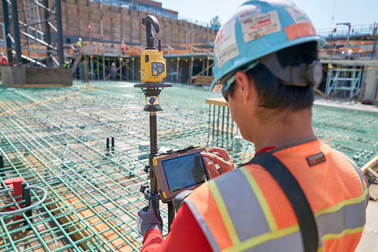
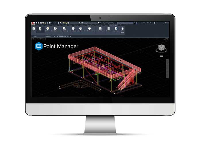
Topcon Positioning Group has released Topcon Point Manager, a point creation software that’s available as a plug-in for Autodesk AutoCAD and Autodesk Revit users in the U.S. and Canada.
According to Topcon, the solution is designed to automate point creation and easily import and export layout files to and from a robotic total station. It’ll also simplify the BIM-to-field process with a faster, more seamless point creation experience from within the design platform, reducing the time and cost of layout, Topcon added.
“Unlike standalone point creation software, which requires the user to leave their particular design environment, users of these two widely used Autodesk technologies will be able to access the solution as a plug-in component to their design package,” said Ray Kerwin, director of Topcon global product planning. “Users will benefit from the ability to automatically create multiple points on BIM objects and 2D/3D drawings from within the Autodesk environments. Just as importantly, however, they will see an increase in their quality assurance and control efforts through easily generated point and deviation reports; a likely reduction in on-site personnel (key during these challenging times), and, with the simplified processes, avoid costly construction errors and rework — the goal of most any operation working in today’s highly competitive construction environment.”
Photo: Topcon Positioning Group
In addition, Topcon MAGNET users can wirelessly send points to the field for layout and completed layout files can be sent back to the office to update the model to match as-built conditions.
“With the cloud-connected MAGNET workflow, BIM personnel or CAD teams can immediately share information to and from the field crew using a layout device. Doing so can prove invaluable, as any conflicts in point data can be quickly identified, keeping production levels up and eliminating costly rework,” Kerwin added.
Topcon Positioning Group designs, manufactures and distributes precision precision measurement and workflow solutions for the global construction, geospatial and agriculture markets.
Golden Software has improved visualization and other functionality in the new version of its Surfer gridding, contouring and 3D surface mapping package. Surfer users now have a greater number of options for displaying their scientific data in the new version, the company said.
Surfer enables users to model data sets, apply an array of advanced analytics tools and graphically communicate the results in ways anyone can understand, Golden Software added.
“In the new Surfer release, we worked on making it easier for users to gain insights into their data sets by providing additional visualization tools,” said Kari Dickenson, Surfer product manager. “New display options also enable users to more easily communicate the information extracted from their data.”
The updated Surfer
In its latest version of Surfer, Golden Software has added the peaks and depressions layer type. This layer type automatically identifies and outlines closed high and low areas, or peaks and depressions, in a grid file. In addition, a statistics report is generated for the areas, including information such as length, width, depth, volume and orientation. The feature also allows high and low areas to be colorized, annotated and displayed on their own.
The company also added four new capabilities to 3D Views: color scale bars can be added to explain the elevation, concentration or other data values depicted by colors; VRML file format exporting enables users to export their 3D Surfer model into another 3D software package or to a 3D printer; anti-aliasing makes axes and grid lines inside the 3D model appear smoother and more professional; and improved 3D PDF exporting has reduced the PDF file size and made the file exporting process faster.
In addition, Golden Software added several existing capabilities to the automation function so that users can write scripts to automate certain workflows. Automated features now include base from data layer type, vector base map symbology, new scale bar options, new legend options and new grid data options. Finally, the new Surfer version allows users to identify objects in vector base maps, such as polygons, polylines or points, by automatically renaming them based on any attribute, as well as select multiple polygons and choose to calculate their statistics, areas or volumes either as a single combined polygon or as individual polygons.
Surfer Beta
Golden Software released a Beta version of Surfer simultaneously with the new version to give customers a chance to try out new features while they are still in development. The three features the company plans to release for the spring/summer 2021 release of Surfer include 3D base maps, contour volume/area calculation and more automated features.
The 3D base maps feature allows .DXF, .SHP and other file formats to be imported with their 3D geometry (3D polylines, polygons and polymeshes) and displayed as three-dimensional features in the 3D View.
A new shortcut also will enable users to calculate volumes and areas above, below or between contour lines with just a few clicks of the mouse, the company said. Finally, additional functions that have been added to automation include point sample, grid project, new classed post layer options and label options for the degrees-minutes-seconds label format.
Golden Software, headquartered in Golden, Colorado, develops 2D and 3D scientific modeling packages.
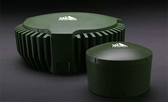
NovAtel’s GPS Anti-Jam Technology (GAJT) product lines achieved a milestone of thousands of units shipped worldwide in 2020. Despite COVID-19, 2020 has proven to be one of NovAtel’s most successful years in protecting positioning, navigation and timing (PNT) from cyber electromagnetic activities (CEMA) for military and civil organizations, the company stated in a press release.
Jamming and interference are growing threats, from a crowded RF spectrum to malicious jamming attempts. However, the GNSS market is responding with anti-jam technologies. Across the world — on land, in the air and at sea — NovAtel customers use GAJT to protect their GNSS navigation and precise timing receivers from intentional jamming and unintentional interference.
The GAJT portfolio includes commercial off-the-shelf solutions with short order lead times for rapid deployment. The range of products can be readily integrated into new platforms or retrofitted into legacy fleets.
Photo: Hexagon | NovAtel
The GAJT-710, its smaller counterpart GAJT-410 and the GAJT-AE variants are used worldwide to protect PNT against jamming and interference no matter the environment.
Beyond defense, GAJT enables users to be proactive against cyber electromagnetic activities using situation awareness technology to indicate the presence and direction of jamming signals.
“Jamming and interference are growing threats worldwide. GAJT protects our customers no matter where they operate,” said Steve Duncombe, executive VP of Aerospace and Defense at NovAtel. “We’re proud to achieve this milestone during a challenging 2020 and will continue delivering assured positioning in our customers’ critical applications with extremely short delivery times.”
Ecobot, developer of environmental data reporting software, is now integrating enhanced Esri ArcGIS mapping and data capabilities via a partnership begun in 2019 through Esri’s Emerging Partner with the Startup Program.
The partnership enabled the addition of familiar geospatial modeling, mapping, georeferencing and data-collection capabilities within the wetland delineation app.
The new capabilities will further automate and speed the process of wetland delineations, allowing Ecobot customers to support paperless mapping of wetlands — scientists and engineers can walk the perimeter of a wetland, dropping virtual flags with a tap on the screen.
The Ecobot natural resources platform includes comprehensive reference materials, automated calculations, and instant generation of U.S. Army Corps of Engineers (USACE) Wetland Determination forms, along with Esri-ready shapefiles.
The addition of Esri ArcGIS technology is expected to slash project time and costs by an additional 5%-8%.
“Ecobot has been used to prepare more than 6,000 USACE forms for jurisdictional determinations,” said Lee Lance, Ecobot co-founder and CEO.
“Accurate and efficient wetland mapping and data collection by scientists is critical to sound construction practices, especially in an era of climate change, when sea rise and heavy precipitation events are predicted to increase across the country,” said Dawn Wright, chief scientist at Esri.
“We are thrilled to see one of our Emerging Business Partners taking advantage of our larger partner network to deliver Esri technology inside of a critical tool.”
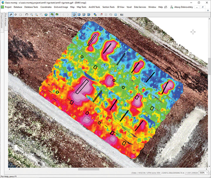
SPH Engineering has launched a drone-integrated metal detection system with a Geonics EM61Lite metal detector, a new product of UgCS Industrial Solutions. The same performance and robustness available for users of the standard EM61-MK2 time domain metal detector are now available for airborne use.
The new system is capable of detecting metallic (magnetic and non-magnetic) items in the first few meters under the surface, finding metallic objects in hard-to-reach or dangerous areas.
Applications include unexploded ordnance (UXO) search, detection of underground infrastructure and archaeology. The integrated system has been extensively tested at SPH Engineering’s test range, and has shown excellent performance and repeatability for targets such as pipes (steel, stainless steel, reinforced concrete) and steel drums.
The system uses an airborne (less heavy) modification of the Geonics EM61-MK2 ground metal detector. The EM61 Lite airborne variant integrates with the UgCS SkyHub onboard computer and ground control station.
Features include automatic data logging in geotagged form and automatic terrain following with radar altimeter. The use of UgCS SkyHub enables the drone to fly in true terrain following (TTF) mode with the help of the radar altimeter and to log geotagged sensor data.
An optional RTK/PPK GNSS receiver on the drone will geotag the data with centimeter-level precision.
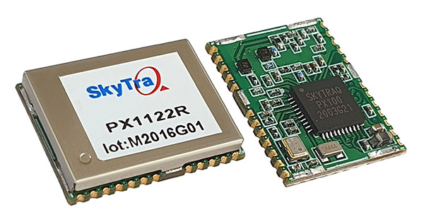
SkyTraq is offering a 12 x 16 millimeter multi-band real-time kinematic (RTK) receiver for centimeter-level accuracy positioning applications. The PX1122R works with all the four GNSS, using GPS L1/L2C, Galileo E1/E5b, GLONASS L1/L2 and Beidou B1I/B2I signals concurrently to maximize positioning availability even in difficult urban environments.
A single-chip system-on-chip, the PX1122R is designed to deliver reliable, centimeter-level accuracy positioning for autonomous unmanned ground or aerial vehicles, the internet of things, and traditional land surveying and precision farming applications.
The PX1122R has an RTK initialization time under 10 seconds and a maximum update rate of 10 Hz. Its update rate provides in-time positioning with a fast response time and improved guidance for fast-moving applications, the company said.
Moving-base RTK for GNSS precise heading is also supported. By using two PX1122R and two antennas with 1-meter separation, highly accurate 1-sigma heading accuracy of 0.13 degree can be obtained; such heading accuracy is immune to magnetic interference and unaffected by the receiver’s speed.
The PX1122R can serve as a key component to provide precise position and heading information for autonomous applications. PX1122R sample, data sheet and evaluation boards are available now.
Founded in 2005, SkyTraq Technology Inc. develops high-performance chipset and module solutions for the consumer market. Its initial product is L1-GPS-centric, and now its products cover L1, L2, L5, L6 band GPS/GLONASS /Beidou/Galileo/QZSS/NavIC/SBAS applications.
Germany is the first United States ally to order the new military code (M-code)-capable Military GPS User Equipment (MGUE).
The Space and Missile Systems Center’s Space Production Corps achieved the major milestone on Sept. 30, when GPS Foreign Military Sales (FMS) office received its first M-code MGUE order.Germany is expected to receive delivery of its first M-code receivers this year.
SMC is facilitating international access and availability of M-code user equipment as directed by the Secretary of the Air Force and the Office of the Secretary of Defense to 58 authorized nations. Additional foreign military sales of MGUE are being worked.
Currently, SMC is engaged with several nations in bilateral M-code prototyping, demonstration and lead platform planning efforts. Under a multilateral agreement, MGUE ground-based receivers are on schedule to be loaned to approved partners for early integration and test in national weapons systems.
M-code is an upgrade to the currently available GPS signals that provides enhanced secure positioning, navigation and timing (PNT) performance, anti-jam and anti-spoofing to provide a more resilient PNT solution. It will improve interoperability with our defense partners’ equipment and operations while increasing navigation warfare effectiveness for allied operations.
If there were ever a time to sit back and reflect on things that have happened in the last calendar year, the year 2020 will be the poster child for the next few generations (at least I hope so…). Because of several things that have happened worldwide in the profession of surveying, let us take this opportunity to look back on a year that was filled with new equipment, emerging technology and government interaction that will have a lasting effect on our surveying horizon.
Look at all of these wonderful toys
There was no shortage of introductions to new equipment for surveyors, especially in the GNSS receiver market. While combining GNSS capability with an inertial measurement unit (IMU) is not a new concept, the Big Three of Leica, Topcon and Trimble introduced new or upgraded versions of their latest receivers taking full advantage of the technology. The benefit of having the IMU integrated within the receiver is the ability to “tilt” the instrument yet having the calculated position remain at the tip of the receiver pole.
Photo: Trimble
Leica, however, takes the tilting feature to another level with an integrated camera that allows for close-range photographs to capture additional information through remote sensing software. The data extracted from the photographs can be simple points (and verified in the data collector while in the field) or point clouds that can be integrated into larger projects through the Leica office software.
These new receivers, along with upgraded models from smaller providers, have opened the GNSS market to many more users well beyond surveying. The combination of more capability through advancing satellite constellations, more robust processors, and reduced receiver sizes have continued to drive GNSS positioning growth.
Photo: Hexagon
Manufacturers are using these increased capabilities to promote better coverage to obtain positions under heavier canopies and less likelihood for multi-path errors. While I remain cautious about these claims of increased coverage, I also maintain that with any tool, measurements and positions must have proper and appropriate validation. However, I am impressed that the technology continues to advance with what was once seen as only applicable to the open sky.
Not all the new technology has emerged through the GNSS receiver product lines; several less visible but valuable features have been introduced within the robotic total station lines. The manufacturers continue to push their equipment to react faster, stay locked on targets better, and provide more reliable solutions to data collection and construction layout. Data collectors continue to evolve with larger screens and more software capability, with some rivaling their desktop counterparts.
As cellular networks grow in both size and speed, more direct connections between field and office are being made with faster response time to data transfer. Data collection can take place in the field and be analyzed by an office technician as it happens. Go another step further and add an aerial background image to the collector and/or the office computer; now each team member can confirm that the information being collected is sufficient for the project in real-time.
Another technology that continues to advance is remote sensing, with more devices being introduced and with increased software capabilities. Besides new and upgraded offerings from the surveying-based manufacturers, other device makers are introducing products that offer remote sensing to the masses. The biggest news in this arena was the announcement from Apple that the iPhone 12 Pro and iPad Pro would come equipped with lidar sensing technology along with incredible photographic capabilities.
While there does not seem to be specific apps developed for surveyors at press time, it is safe to say that there will be in short order. It is also a safe bet that having this capability on a mass-produced device will put pressure on the surveying and mapping equipment manufacturers to be cost-competitive on their own proprietary devices or risk losing out on market share.
UAVs continue to be the fastest-growing segment of the surveying industry. More vehicle, sensor and software providers are coming to market to offer the surveyor a variety of choices. DJI continues to lead the way in the multi-rotor category with new products and sensors while other manufacturers are embracing the fixed-wing and vertical take-off and landing (VTOL) platform for greater range.
Just like their automobile brethren, flight time continues to increase with discoveries of new battery compositions and weight considerations. The sensor market is expanding to include more affordable lidar units, as well as new technology in multispectral identification, gas and noxious odor detection, and much more.
Software developers, too, continue to refine and expand the features found in their geospatial offerings with advancing technology and programming. Google Maps is the default navigation app for many smartphone users, but like anything utilizing GNSS in dense urban areas, the users find themselves bouncing all over the map.
2020 did not see any shortage of government action for the surveying and mapping community. As with many topics that come out of the nation’s capital, it should not surprise anyone that several of the items considered by the federal government and its agencies were not without controversy.
The biggest and most controversial item continues to be the advancement of Ligado (formerly known as LightSquared) and the development of new communication technology that has been shown to interfere with the GPS transmission bands. The Federal Communications Commission (FCC), led by Chairman Ajit V. Pai, has been successful in holding off all challenges to the new technology including ones from current legislators and defense staff.
The main argument from the FCC is the value of the system as a provider of 5G communication to a substantial portion of the country. They also make statements that safeguards are being taken to protect the GPS spectrum, yet many studies from outside parties show otherwise. The fight over this spectrum will continue into 2021, and it will be interesting to see if the new administration will see things from a different perspective.
Several items to come out of Washington, D.C., late in the year were the blacklisting of DJI and the announcement of new UAV rules for flying over crowds and at night. With the DJI ruling, it is now illegal for government agencies to use the Chinese-based UAV maker for any activities. Based upon the significant market share of DJI, one can only wait to see how this situation plays out, and if the ban is expanded to private individuals.
The FAA announcement on the new UAV flight rules was surprising but not unexpected. In addition to establishing flight limitations over crowds and at night, it also established a timeframe for requiring most UAVs to transmit a Remote ID during flight for determining who is flying and where they are located. Compliance with these rules will be required by the manufacturer within 18 months and by UAV pilots within 30 months.
The National Geodetic Survey (NGS) has also been busy during 2020 preparing new datums and specifications for upcoming changes to the National Spatial Reference System (NSRS). Among those changes are the deprecation of the U.S. Survey Foot, beta testing of the latest geoid model (GEOID20), and new software tools for transforming positional information between datums. It was also announced that the release of the modernized NSRS scheduled for 2022 was being delayed.
NGS continues to work with each state on the improved state plane coordinate systems and/or low distortion projection systems that will be implemented with the new NSRS rollout. All these efforts have been a monumental task (no pun intended) and kudos go out to NGS for getting everything this far.
Pandemic 2020 (No, this is not a movie or a drill)
As we covered in the May 2020 Survey Scene article, COVID-19 was unlike anything we had been exposed before. Initial reports tried to relate the virus to typical influenza and the H1N1 outbreak in 2009, but the rapid transmission and sheer volume of cases (and deaths) mostly eliminated those comparisons.
From a technical viewpoint, the situation with COVID-19 has no bearing on GNSS operations and positional establishment. An operator of a GNSS receiver, and the business of surveying, is greatly affected by the presence of COVID-19 so it does deserve more than a brief mention in a retrospective look at the past year. This virus upended everything; from data collection and survey-related activities to computations and final drafting, the business of surveying felt the effects.
Once the initial challenges of keeping everyone safe were addressed, it became a year-long marathon of providing surveying services to clients that did not let the pandemic hinder their progress. Field crews were under significant pressure to maintain social distancing at every turn, while office staff dealt with home Wi-Fi and lack of access to normal business conditions such as large-format printing.
Video calls and instant messaging quickly became the norm, yet also became the scourge of dealing with the day-to-day operations of a business. The “normal” work/life balance with families, school, and social activities has disappeared and a more challenging approach has replaced that balance. Fingers are crossed that people will adhere to social distancing protocols and can get vaccinated as soon as possible so we can resume a portion of our previous lifestyles.
However, we do have several positive things to take away from the challenges of the pandemic that will make our lives better going forward. Our reliance on geolocation became quite clear throughout the pandemic. Whether it is using it to help establish contact tracing or as simple as having a delivery service bring necessities straight to your door, almost everyone relies on geolocation for helping guide them through the “new normal.”
We are using our smartphones to track our family members and help keep them out of harm’s way. It would be hard to imagine how much more difficult this situation would have been before cellphone and GNSS integration.
Graphic: World Health Organization (https://www.who.int/emergencies/diseases/novel-coronavirus-2019).
Another leap forward that most people are not aware of is the publicizing of GIS dashboards and incredible analysis of the geolocation of people worldwide. While GIS dashboards have been in existence for many years, it is only now that the public has paid attention to the vast information available to them.
From providing numbers of cases to graphically depicting “hotspots” across the world, these dashboards are full of useful information to help people understand the size of this pandemic, the places where mitigation is working, and where additional restrictions are being put in place to help reduce the spread of COVID-19.
The ability to merge geolocations with physical conditions and situations into a real-time mapping solution can help reduce the spread of the virus. By combining GNSS technology with advanced computing power and data storage, the power of GIS has been brought to the front page of public agencies and news sites.
While we still enjoy watching movies with superheroes, the true heroes during this pandemic are the frontline health workers, first responders and data analysts/programmers who bring us this timely information quickly. A hearty thank you goes out to all of them for their efforts and dedication to the cause.
In memoriam
Photo: GPS World staff
The year 2020 also brought losses to every corner of the world and the surveying community was not spared. There are very few individuals we call pioneers in the surveying industry, so to include Dr. Javad Ashjaee among that group is no small feat. His contributions to the surveying profession helped turn every practitioner into a geospatial information provider.
From his early days at Trimble pioneering the commercial-grade receiver to creating his company at Ashtech and embracing GLONASS with GPS, he continued to expand the capability of the GNSS receiver. Many surveyors today only know his name through his latest company, Javad GNSS, and the unique line of receivers and measuring devices and their distinctive green color.
Cover photo: Ed Koziarski
Dr. Ashjaee was a big part of the GNSS revolution, so next time you starts up their receiver to collect survey data, take a moment to thank him. It was my pleasure to meet and interview him at the 2017 Intergeo trade show in Berlin to talk about his product line. I was also able to test-drive his incredible GNSS products for a feature in GPS World magazine on using smartphones for data collectors.
To say the man will be missed is a big understatement and I wish his family well on continuing his company and tradition of making great leaps in technology.
Teledyne Technologies will acquire FLIR Systems in a cash and stock transaction valued at $8 billion, both companies announced on Jan. 4.
Teledyne is a provider of sophisticated instrumentation, digital imaging products and software, aerospace and defense electronics, and engineered systems. Its operations are primarily in the United States, Canada, the United Kingdom, and Western and Northern Europe.
Founded in 1978, FLIR is an industrial technology company focused on intelligent sensing solutions for defense and industrial applications.
Under the terms of the agreement, FLIR stockholders will receive $28 per share in cash and 0.0718 shares of Teledyne common stock for each FLIR share, which implies a total purchase price of $56.00 per FLIR share based on Teledyne’s five-day volume weighted average price as of December 31, 2020. The transaction reflects a 40% premium for FLIR stockholders based on FLIR’s 30-day volume weighted average price as of Dec. 31, 2020.
As part of the transaction, Teledyne has arranged a $4.5 billion 364-day credit commitment to fund the transaction and refinance certain existing debt. Teledyne expects to fund the transaction with permanent financing prior to closing. Net leverage at closing is expected to be approximately 4.0x adjusted pro forma EBITDA with leverage declining to less than 3.0x by the end of 2022.
Teledyne expects the acquisition to be immediately accretive to earnings, excluding transaction costs and intangible asset amortization, and accretive to GAAP earnings in the first full calendar year following the acquisition.
“At the core of both our companies is proprietary sensor technologies. Our business models are also similar: we each provide sensors, cameras and sensor systems to our customers. However, our technologies and products are uniquely complementary with minimal overlap, having imaging sensors based on different semiconductor technologies for different wavelengths,” said Robert Mehrabian, executive chairman of Teledyne. “For two decades, Teledyne has demonstrated its ability to compound earnings and cash flow consistently and predictably. Together with FLIR and an optimized capital structure, I am confident we shall continue delivering superior returns to our stockholders.”
“FLIR’s commitment to innovation spanning multiple sensing technologies has allowed our company to grow into the multi-billion-dollar company it is today,” said Earl Lewis, chairman of FLIR. “With our new partner’s platform of complementary technologies, we will be able to continue this trajectory, providing our employees, customers and stockholders even more exciting momentum for growth. Our board fully supports this transaction, which delivers immediate value and the opportunity to participate in the upside potential of the combined company.”
“We could not be more excited to join forces with Teledyne through this value-creating transaction. Together, we will offer a uniquely complementary end-to-end portfolio of sensory technologies for all key domains and applications across a well-balanced, global customer base,” said Jim Cannon, FLIR president and CEO. “We are pleased to be partnering with an organization that shares our focus on continuous innovation and operational excellence, and we look forward to working closely with the Teledyne team as we bring our two companies together to capitalize on the important opportunities ahead.”
Fourth-quarter financial results. In a separate press release issued today, Teledyne announced improved preliminary financial results for the fourth quarter and full year 2020. The Teledyne press release is available on www.teledyne.com. FLIR noted today that it expects to meet or exceed the full year fiscal 2020 guidance it provided on Oct. 30.
Approvals and timing. The transaction, which has been approved by the boards of directors of both companies, is expected to close in the middle of 2021 subject to the receipt of required regulatory approvals, including expiration or termination of the applicable waiting period under the Hart-Scott-Rodino Antitrust Improvements Act, approvals of Teledyne and FLIR stockholders and other customary closing conditions.
Advisors. Evercore is acting as exclusive financial advisor and McGuireWoods LLP is acting as legal advisor to Teledyne in connection with the transaction. Goldman Sachs & Co. LLC is acting as exclusive financial advisor and Hogan Lovells US LLP is acting as legal advisor to FLIR in connection with the transaction. Teledyne has entered into a 364-day senior unsecured bridge facility credit agreement with Bank of America as sole lead arranger and administrative agent.
Conference call and webcast. Teledyne and FLIR hosted a conference call to discuss the acquisition. A replay is available and will be available for one month.
By Danny Baird NASA’s Space Communications and Navigation program office
The Artemis generation of lunar explorers will establish a sustained human presence on the Moon, prospecting for resources, making revolutionary discoveries and proving technologies key to future deep space exploration.
To support these ambitions, NASA navigation engineers from the Space Communications and Navigation (SCaN) program are developing a navigation architecture that will provide accurate and robust position, navigation and timing (PNT) services for the Artemis missions. GNSS signals will be one component of that architecture. GNSS use in high-Earth orbit and in lunar space will improve timing, enable precise and responsive maneuvers, reduce costs, and even allow for autonomous, onboard orbit and trajectory determination.
On Earth, GNSS signals enable navigation and provide precise timing in critical applications like banking, financial transactions, power grids, cellular networks, telecommunications and more. In space, spacecraft can use these signals to determine their location, velocity and time, which is critical to mission operations.
“We’re expanding the ways we use GNSS signals in space,” said SCaN Deputy Director for Policy and Strategic Communications J.J. Miller, who coordinates PNT activities across the agency. “This will empower NASA as the agency plans human exploration of the Moon as part of the Artemis program.”
Spacecraft near Earth have long relied on GNSS signals for PNT data. Spacecraft in low-Earth orbit below about 1,800 miles (3,000 km) in altitude can calculate their location using GNSS signals just as users on the ground might use their phones to navigate.
This provides enormous benefits to these missions, allowing many satellites the autonomy to react and respond to unforeseen events in real time, ensuring the safety of the mission. GNSS receivers can also negate the need for an expensive onboard clock and simplifies ground operations, both of which can save missions money. Additionally, GNSS accuracy can help missions take precise measurements from space.
Expanding the Space Service Volume
This photograph of a nearly full Moon was taken from the Apollo 8 spacecraft at a point above 70 degrees east longitude. Mare Crisium, the circular, dark-colored area near the center, is near the eastern edge of the Moon as viewed from Earth. (Image: NASA)
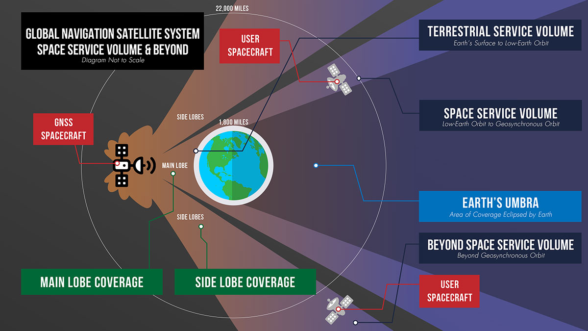
Beyond 1,800 miles in altitude, navigation with GNSS becomes more challenging. This expanse of space is called the Space Service Volume, which extends from 1,800 miles up to about 22,000 miles (36,000 km), or geosynchronous orbit. At altitudes beyond the GNSS constellations themselves users must begin to rely on signals received from the opposite side of the Earth.
From the opposite side of the globe, Earth blocks much of the GNSS signals, so spacecraft in the Space Service Volume must instead “listen” for signals that extend out over the Earth. These signals extend out at an angle from GNSS antennas.
Formally, GNSS reception in the Space Service Volume relies on signals received within about 26 degrees from the antennas’ strongest signal. However, NASA has had marked success using weaker GNSS side lobe signals — which extend out at an even greater angle from the antennas — for navigation in and beyond the Space Service Volume.
Since the 1990s, NASA engineers have worked to understand the capabilities of these side lobes. In preparation for launch of the first Geostationary Operational Environmental Satellite-R weather satellite in 2016, NASA endeavored to better document side lobes’ strength and nature to determine if the satellite could meet its PNT requirements.
“Through early on-orbit measurement and documentation of the GNSS side lobe capabilities, future missions could rest assured that their PNT needs would be met,” said Frank Bauer, who began the GNSS PNT effort at NASA’s Goddard Space Flight Center in Greenbelt, Maryland. “Our understanding of these signal patterns revealed a host of potential new GNSS applications.”
Navigation experts at Goddard reverse-engineered the characteristics of the antennas on GPS satellites by observing the signals from space. By studying the signals satellites received from GPS side lobes, engineers pieced together their structure and strength. Using this data, they developed detailed models of the radiation patterns of GPS satellites in an effort called the GPS Antenna Characterization Experiment.
While documenting these characteristics, NASA explored the feasibility of using side lobe signals for navigation well outside what had been considered the Space Service Volume and in lunar space. In recent years, the Magnetospheric Multiscale Mission (MMS) has even successfully determined its position using GPS signals at distances nearly halfway to the Moon.
A graphic detailing the different areas of GNSS coverage. (Image: NASA)
GNSS at the Moon
To build on the success of MMS, NASA navigation engineers have been simulating GNSS signal availability near the Moon. Their research indicates that these GNSS signals can play a critical role in NASA’s ambitious lunar exploration initiatives, providing unprecedented accuracy and precision.
“Our simulations show that GPS can be extended to lunar distances by simply augmenting existing high-altitude GPS navigation systems with higher-gain antennas on user spacecraft,” said NASA navigation engineer Ben Ashman. “GPS and GNSS could play an important role in the upcoming Artemis missions from launch through lunar surface operations.”
While MMS relied solely on GPS, NASA is working toward an interoperable approach that would allow lunar missions to take advantage of multiple constellations at once. Spacecraft near Earth receive enough signals from a single PNT constellation to calculate their location. However, at lunar distances GNSS signals are less numerous. Simulations show that using signals from multiple constellations would improve missions’ ability to calculate their location consistently.
To prove and test this capability at the Moon, NASA is planning the Lunar GNSS Receiver Experiment (LuGRE), developed in partnership with the Italian Space Agency. LuGRE will fly on one of NASA’s Commercial Lunar Payload Services missions. These missions rely on U.S. companies to deliver lunar payloads that advance science and exploration technologies.
NASA plans to land LuGRE on the Moon’s Mare Crisium basin in 2023. There, LuGRE is expected to obtain the first GNSS fix on the lunar surface. LuGRE will receive signals from both GPS and Galileo, the GNSS operated by the European Union. The data gathered will be used to develop operational lunar GNSS systems for future missions to the Moon.
Positioning, navigation and timing (PNT) orbs guide 50-ton robots carrying containers at the Ports of Auckland.
In a world-exclusive report, GPS World visited with officials at the Ports of Auckland, New Zealand, and the Australian company Locata to reveal a revolutionary port automation system. Locata’s navigation system could change the way containers are handled around the globe, and open the floodgates for next-generation automation of Critical National Infrastructure sites.
Global shipping lines, ports and container terminals are at the heart of the immense, multi-trillion-dollar global logistics market, and ports are classed as critical infrastructure in many nations.
Much of the world’s port infrastructure is old, has no space to expand, and strains at the seams as it faces the reality of handing larger cargo volumes and massive new container ships —some with more than 22,000 containers on board. Efficiently managing the huge spike in container moves caused by the arrival of these gigantic new vessels is a critical requirement for container terminals and their logistics chains, and the problem will only become more acute.
Once arriving at port, container vessels are offloaded by ship-to-shore (STS) cranes. (Photo: bfk92/E+/Getty Images)
Automating operations at ports and intermodal hubs to accelerate their throughput is an obvious solution. “Automate or die” is now an accepted industry mantra, and indeed a small number of terminals around the world have been automated in the past. Early attempts at using GPS for positioning autonomous machines promptly fizzled, however. A chaotic environment of gigantic moving metal machines and constantly changing metal container stacks creates insurmountable blockage and multipath position errors. The environment makes it impossible to guarantee ultra-reliable, centimeter-level GNSS positioning.
In the past, the industry had to resort to providing basic-level positioning by drilling holes to install (with no exaggeration) between 50,000 and 500,000 RFID transponders or magnets in the port’s pavement. This was extremely tedious and labor intensive, and came with serious downsides. The transponders do not work well for differing machine sizes because they usually require reader antennas, the size of two regular house doors, under the machine. Furthermore, the drilling deteriorates the pavement — the ports’ most valuable asset.
The biggest problem, however, was that for a fully operational site like Auckland — known as brownfields in the industry — the port often would have to be closed for years to allow the transponders and pavement to be installed. Such a shutdown isn’t feasible for most operating ports; hence, brown-fields were considered next-to-impossible to automate.
Although this may seem to be less of an issue for new greenfields ports (those built from scratch), buried transponders essentially lock in the mobility and usage patterns for any port, requiring another shutdown to make changes. In all, the logistics industry and its machine manufacturers urgently need a viable, flexible, reliable positioning solution for terminal automation — and soon.
A New Solution
It’s now been revealed that a new solution for this urgent requirement had, in fact, been in stealth mode development for many years. Due to commercial competitive considerations, all the work had taken place under the radar and without publicity. Konecranes, the largest port machine manufacturer, had been developing fully autonomous straddle carriers specifically to address this market, in partnership with Australian company Locata Corporation.
This totally new automation system is being rolled out now at multiple terminals around the world. The first port to emerge with this trailblazing capability is the Ports of Auckland.
Locata’s ground-based GNSS-like positioning system is changing the game for logistics terminals. The Ports of Auckland is the first of many ports and logistics hubs around the globe currently operating or installing Locata (see Figure 1). In the process, the port is delivering the global logistics industry a raft of world-first capabilities.
Figure 1. The Ports of Auckland covers 140 acres at the doorstep of Auckland’s central business district. The outline shows the approximate coverage of the LocataNet local positioning system (landside only). (Photo: Ross Clark/Ports of Auckland)
Partners on this project — the government owners of the Ports of Auckland; its system supplier Konecranes; and Locata — are breaking new ground and in the process opening the floodgates for next-generation machine automation of critical national infrastructure sites.
Groundbreaking Capabilities
Living on an island means every-day items are delivered via cargo ships. That’s certainly the case in Auckland, New Zealand’s largest city, which has a harbor on the Pacific Ocean.
The Ports of Auckland is the largest terminal for commercial freight that arrives in New Zealand. Its 140-acre international trade port is in the heart of the city and surrounded by water, so expansion by reclaiming land is out of the question, even as the country continues to grow.
With this situation, the port’s operator was faced with the seemingly impossible: double the handling capacity of the port in a few years without reclaiming any more land. They turned to automation and cutting-edge technology to find a solution.
Everything that arrives at the port is in a standardized shipping container. The port’s plot of land is usually crammed with the maximum number of containers it can hold. The Ports of Auckland had to seek out automation that increases the terminal’s capacity by stacking containers higher, stacking them close together, and generally making things move faster and more efficiently.
For inbound cargo, once a container is unlocked from its ships, ship-to-shore (STS) cranes unload them to ground level. Straddle carriers then lift and move each container to a ground-level holding area, where it is stored and then transferred to a truck or a train that will deliver it to its ultimate destination.
Export cargo arrives at the port via truck or train, and the straddle carriers handle them through the port’s storage areas to be loaded onto a ship.
The port also handles trans-shipments; containers that arrive via a ship destined to be loaded onto another ship. These handling processes are repeated over and over around the clock, operating pre-automation at a capacity of around 900,000 containers per year.
Straddle carriers are the workhorses of the operation, moving containers within the port. Manual straddles are operated by trained onboard drivers and can stack containers two high. In a traditional manual environment, a driver’s time is divided between tasks that require skill such as picking up a container from the STS crane, or on repetitive work — like organizing containers for efficient loading onto ships, trains and trucks — which are tasks that can readily be automated.
By adding automation, the Ports of Auckland created a mix of manual and automated straddles working together at the terminal. Drivers are assigned the more interesting and skillful tasks, while the automated robotic straddles carry out the repetitive, “boring” tasks.
“Very soon, when the automation system is fully implemented, our straddle carrier fleet will consist of 27 Konecranes Fully-Automated Straddle Carriers (A-STRAD), and 24 manned straddle carriers,” said Ross Clarke, program manager of Auckland’s Port Automation Project. “This interaction of manned and automated machines, without any physical infrastructure separating them, is a world first.”
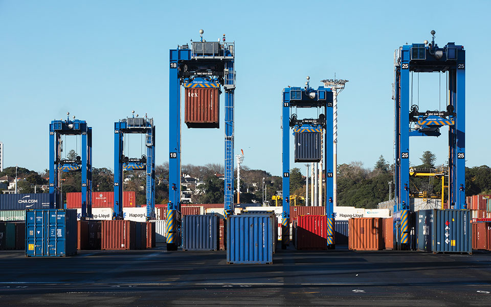
The A-STRADs are bigger than the manual straddles. The 50-ton, four-story-high machines can move 40-foot containers weighing 50 tons around the port at up to 30 kilometers per hour. Each can stack containers up to three high and closer together.
Five fully autonomous Konecranes A-STRADs at work in the Ports of Auckland. The Locata VRay Orb antennas can be seen at the top of each straddle. (Photo: Photo: Ross Clark/Ports of Auckland)
With the new automated system, the Ports of Auckland will almost double the capacity of the terminal to 1.7 million containers per year once automation is fully implemented in early 2021.
The Ports of Auckland chose Konecranes to supply the fully-autonomous straddle carriers. With no cab, A-STRADs are uniquely identifiable as autonomous. A-STRADs can drive around the port, lifting and moving containers in the same way as their manual predecessors, using their spreader and assisted by the onboard sensors. A critical difference is how they position themselves and how they safely operate in an environment with many other objects, manual straddles, A-STRADs and container stacks.
At the heart of this capability is the Locata local positioning system. It allows A-STRADs to reliably position themselves to centimeter-level accuracy throughout the terminal work area. Every A-STRAD has two Locata antennas, each attached to a Locata Rover receiver, that enable an A-STRAD to accurately determine its position and orientation.
Driver Assistance. Both the A-STRADs and the manual straddles at the Ports of Auckland are positioned using Locata technology. The manned straddle carriers are fitted with a driver-assistance system, which is also positioned by Locata, so their operations can be monitored and coordinated in lock-step with autonomous A-STRADs.
“The driver assistance system operates a lot like the auto-parking system in a car,” Clarke said. “When manned straddles are near the interchange area where they interact with A-STRADs, operators change to driver-assist mode and can take their hands off the steering wheel, allowing the system to autonomously guide the straddle carrier to the correct stack location with an accuracy of +/–3 cm.”
Roots of a New Strategy
The groundbreaking positioning system has been in the works for several decades.
“Locata has been working on this ‘terrestrial replica of GNSS’ capability for 25 years,” Locata CEO Nunzio Gambale told GPS World. “It didn’t spring up one day just because co-founder David Small and I thought, hey, we’d like to replace the GPS satellites.
“Our driving vision has been to provide accurate performance in myriad environments where we always knew GNSS was going to fail to deliver,” Gambale continued. “Importantly, what you see today is not just ‘a lab experiment’ or a prototype test system. It’s operationally deployed, enabling some of the most demanding positioning applications on Earth. Our team has been laser-focused on developing real technology which improves on GPS-like positioning, and delivering solid solutions for real-world problems modern applications now face.”
The Locata System
Two LocataLite transmitter antennas, installed 23 meters up a light pole, provide high-accuracy positioning coverage over part of the Ports of Auckland. (photo: Photo: David Small/Locata)
LocataLites. Locata is a local positioning system that uses a network of synchronized transmitters, known as LocataLites, installed in and around the port to cover all straddle work areas. The LocataLites work like miniature GPS satellites, transmitting GPS-like signals using two frequencies in the 2.4-GHz ISM band.
LocataLites are strategically installed and configured to deliver reliable centimeter-level accuracy, with particular attention paid to the geometry available from the network when the installation layout is designed. This LocataLite network (called a LocataNet) enables the equipment on each straddle carrier to trilaterate its position using a method similar to GNSS positioning.
Locata technology is built upon two critical proprietary capabilities developed and perfected over many years: TimeLoc and multipath mitigation. To date, Locata has been granted more than 160 patents on these core advances.
Sub-Nanosecond TimeLoc. First, LocataLites use their own broadcast signals to time synchronize with each other using a proprietary technology called TimeLoc. This allows all the LocataLites in a LocataNet to time synchronize with each other to sub-nanosecond levels without requiring atomic clocks.
Mutipath Mitigation. Second, Locata’s proprietary multipath mitigation technology enables Locata receivers to correctly track direct signals, even in an environment filled with reflected signals. Multipath is the main reason GNSS can’t deliver the accuracy and reliability required at a port.
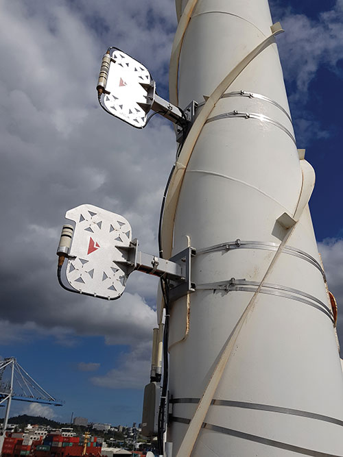
Locata’s multipath mitigation technology has two components: the Locata receiver and the VRay Orb antenna.
Locata receivers. The receivers incorporate a proprietary signal-processing technique, correlator beamforming (CBF), which delivers beam-forming capability comparable to advanced phased-array antennas.CBF allows the Locata receiver to combine signal samples from its multiple antenna elements to form virtual “beams,” and any signal outside of a given virtual beam is ignored.
Unlike traditional phased arrays, however, the Locata CBF system is markedly less complex and orders of magnitude less expensive. CBF uses only one RF front end, yet it can form millions of individually-steered beams per second.
VRay Orbs. The straddle carriers at the Ports of Auckland are the first commercial operating deployment of Locata’s VRay Orb antennas, with two orbs atop every A-STRAD as well as the manual straddles (Opening Photo).
A row of Locata VRay Orb60 antennas atop Konecranes A-STRAD machines stretch into the distance toward Auckland’s business district. (Photo: David Small/Locata)
Bespoke Positioning
The placement of LocataLite positioning transmitters on any site is entirely within the control of the LocataNet designer. “Our partners can place them where they want, in as high a density as they want, and as accurately as they need to get their job done,” Gambale said. “The LocataNet delivers rock-solid, super-reliable positioning in environments where that wasn’t possible before.”
With GNSS, users have no control over the geometry of the satellites in view. “That’s a huge problem in many of these high-accuracy applications because it can greatly affect your DOP [dilution of precision] geometry,” he added. “Engineers trying to rely on GNSS can see huge variability — or complete failure — in a machine’s position. Unreliable positioning is not acceptable when an enterprise is relying on 50-ton autonomous machines, doing critical work that you cannot afford to stop.”
According to Clarke, “Locata is well-suited to our requirements as it offers high precision, high resistance to interference, and high reliability.”
Breakthroughs at the Port
Locata’s enabling technology has brought multiple breakthrough advantages to terminal automation. Critical among them is the ability to automate a terminal while in full operation.
“Because our container terminal is working at high utilization, with no spare space to operate, we are deploying the automation in two phases,” Clarke said. “The first phase started commercial operations in August 2020, and we have now handled more than 35 ships using the automated system. The next phase, with the entire terminal running fully operational automation, is scheduled to enter service in early April 2021.”
Flexibility. The new system also provides extreme flexibility to alter the layout of operations in real time, something never possible with transponders embedded in the ground. A-STRADs drive around using a digital map. With Locata, this map can be changed as often as needed without having to change anything in the infrastructure.
Reduced Wear and Tear. Before automation, line markings on the pavement guided operators on paths and in storage areas. While this kept operations orderly, following the marked lines caused ruts in the pavement that eventually require costly and time-consuming repairs.
“With A-STRAD positioning being so precise and repeatable, this accuracy could have caused serious ruts and also become a problem,” Clarke said. “With Locata and the ‘invisible’ digital pavement markings, we came up with a cool solution to this that we call ‘stack shuffling.’ We shift the digital drive paths and storage plots over time so that wear and tear on the pavement is spread more evenly, requiring fewer repairs to the tarmac.”
The shuffling is imperceptible to a human, but the A-STRADs are spreading the wear across the entire tarmac and greatly extending the service life of the terminal surface, according to Clarke.
Less Fuel. The automation also brings significant environmental benefits. “A-STRADs use approximately 10% less fuel, which means they are indeed cheaper to run,” Clarke said.
Locata-enabled manned straddles near STS cranes unload a ship at dusk. (Photo: Photo: David Small/Locata)
Autonomous and Manned
Ensuring the safety of workers, machinery and cargo is a critical requirement at any port. All parts of the Ports of Auckland’s new system were tested for two years, including system software from both Konecranes and Locata.
The software was tested in pieces as it was developed. Then, full system functionality was delivered and tested. Both automated and manual straddles are centrally monitored and coordinated by this terminal operating system.
Working Together. Auckland’s port is the first in the world to use autonomous and manned machines together without a physical separation. This allows skilled operators to manually handle operations in specific areas, while the autonomous A-STRADs are tasked with monotonous and time-consuming jobs with no practical limitation on the machine’s repeatability.
Within the access-controlled premises in Auckland, all work areas are constantly monitored by the centralized system. The Locata system tracks the location of all straddle carriers at all times.
Training. All manual straddle drivers go through virtual and hands-on training with specific attention paid to safety protocols.
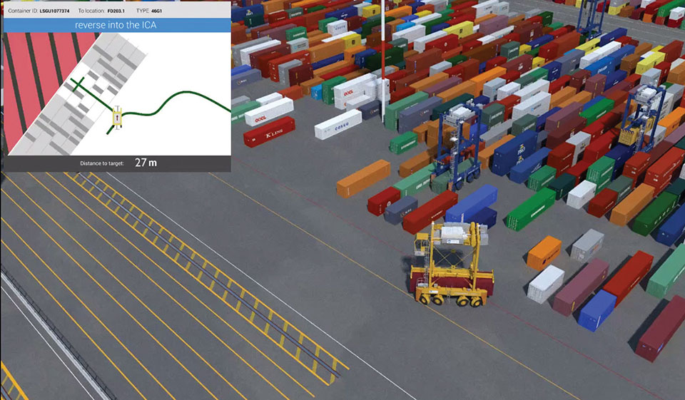
“Once they’ve first learned what to do in a simulator,” Clarke said, “they then carry out the same tasks with an instructor in a real straddle carrier. We also train our control room staff in a virtual training environment that’s a bit like a container terminal version of a flight simulator.” Figure 2 shows the screen of the operator training simulator.
Figure 2. The straddle carrier simulator used for manual straddle operator training shows (top left) the container drop-off location, designated path, and open and restricted zones. (Photo: Ross Clark/Ports of Auckland)
Laser Scanners. As a last line of defense, autonomous A-STRADs are equipped with laser scanners that detect obstacles and automatically engage collision prevention measures, if required.
More Locata Applications
Port machinery automation is the most recent industrial sector to reveal the adoption of Locata technology. However, Locata is already used by large industry partners for deep-pit mining where mine pit walls act like deep urban canyons and severely limit the sky view. (See GPS World, March 2017.)
Locata also is being used as the core truth reference positioning system at the U.S. Air Force (USAF) White Sands Missile Range. There, it is independently providing high-accuracy non-GPS-based positioning when GPS signals are heavily jammed; this is practically the Holy Grail for alternative PNT, and the USAF has been using the system operationally at White Sands since 2016. (See GPS World, January 2020.)
NASA is another Locata user, working with the Federal Aviation Administration on research for next-generation air traffic control. Numerous other applications are currently in stealth development.
Gambale said the company’s technology is not representative of a solution just for ports, mines, aviation, military or any other specific application. “Our ground-based technology has myriad advantages in the many environments where satellite-based positioning was never designed to work. We can change the game for many modern applications because Locata allows users to have total control over where transmitters are placed, the power they transmit, the design of their network structure, and much more.”
For more than 10 years, the company worked to develop technology to reduce multipath — the bane of high-accuracy GNSS positioning in urban, industrial, indoor and occluded areas.
“Those are all real-world environments where satellite-based signals cannot be tracked reliably enough for next-gen, extremely demanding applications like fully-autonomous operations,” Gambale said. “Our business is the direct result of GPS changing the world, and the industry then fueling a largely unqualified public expectation that centimeter-level positioning would be available everywhere. Clearly, that is not correct.
“The growing roster of huge, globally significant companies adopting our technology for applications that go beyond GPS limitations shows our developments deliver real benefits to many markets. Auckland is living proof that Locata is a true, terrestrial, centimeter-accurate alternative-PNT system.”
For the past decade, widespread deployment of autonomous vehicles (AV) has been just over the horizon — that imaginary line that recedes as you approach it.
It has been delayed mainly by technical issues, which will eventually be followed by legal and regulatory ones, mainly regarding liability, and by a struggle to gain public acceptance. When they finally reach the mass market, however, AVs will reduce traffic fatalities by at least an order of magnitude because they do not get distracted, drunk, drowsy or enraged and are much better able than humans to gauge distances and speeds.
Additionally, they will be able to communicate with each other and with the infrastructure, which will not only further improve safety but also reduce congestion and fuel consumption via the adoption of techniques such as convoying.
Logically, even if AVs only somewhat reduced traffic fatalities (about 38,000 per year in the United States), the public should welcome them with open arms. In reality, though, the reaction to even a single death caused by an AV — like the one in Tempe, Arizona, in March 2018 — can set AV deployment back years.
Therefore, car manufacturers are challenged to develop AVs that can navigate extremely safely in a wide range of traffic, road and weather conditions. For more than a century, human drivers have routinely managed sudden obstructions, poor visibility and dangerous behavior by other drivers that still bedevil their new robotic counterparts, despite the sensors, microprocessors and algorithms at their disposal.
The primary technological obstacle to widespread deployment of AVs on roads is “the complexity of the system and the amount of time that it takes to develop a functionally safe autonomous vehicle,” said Steve Ruff, general manager of Trimble’s On-Road Autonomy Division, which develops positioning solutions for autonomous vehicles that operate on public roadways. He cites the time required to develop “a comprehensive, safe, autonomous vehicle technology stack” and points out that “we are on the verge of going from level two to level three, which requires the driver to stay engaged in the driving experience in case the autonomous system has a problem.”
Multiple sensors
While AV developers are exploring different ways of obtaining reliable sub-centimeter positioning accuracy, all generally rely on collecting data from multiple sensors on the vehicle and applying an algorithm to synthesize the data in real time and generate a continuous, accurate position. Computer vision, radar and lidar play important roles in an AV by perceiving its surroundings and localizing it to an a priori map. This functions well in feature-rich urban environments, but can degrade in sparse highway settings.
Radar has good ranging accuracy, but is unable to detect and recognize traffic signs and road markings. Lidar has even greater ranging accuracy but is challenged in featureless areas, such as straight highways and country roads. Digital cameras are good for detecting objects and navigating in tunnels and urban canyons, but, like lidar, are less effective on featureless roads and in low visibility conditions (rain, fog, darkness, snow, sun glare).
Plus, they are challenged by the absence of road markings or the presence of construction. Inertial navigation systems (INS), while excellent at compensating for brief GNSS outages, can only guide vehicles for short stretches due to their inherent drift. (INS are essential on aircraft and vessels, whose attitude is constantly changing, but that is not relevant for vehicles, which travel essentially flat relative to, and at a constant distance from, the road surface.)
GNSS and Corrections
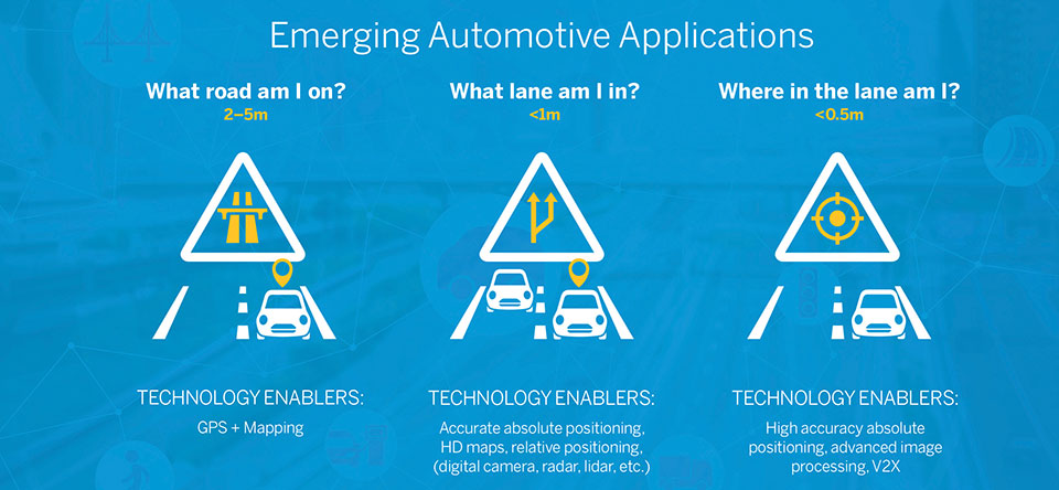
Satellite navigation plays a central role in an AV. At a minimum, it guides it from a trip’s origin to its destination, including stops or waypoints in between, the same way it would advise a human driver. It also continuously alerts the vehicle to upcoming stops, slowdowns, turns, congestion and other challenges that are already mapped—whether long in advance by map makers or moments earlier via crowdsourced updates. Finally, if sufficiently accurate, it can steer the vehicle to keep it in the center of its lane and to make smooth lane changes and turns. Determining on which road a vehicle is requires an accuracy of less than 5 meters; determining in which lane it is requires an accuracy of less than 1 meter; and determining where in the lane it is requires an accuracy of less than 0.5 meters.
Two kinds of GNSS corrections are commonly used for AVs: real-time kinematic (RTK) and precise point positioning (PPP). RTK, which is generally accurate to the centimeter level, relies on ground-based reference stations at fixed, surveyed locations that process and transmit error-corrected signals to receivers within a 10- to 20-kilometer range, typically in real-time via a cellular link. PPP, which is accurate to the tens of centimeters, uses a global network of ground stations to generate an accurate signal, and transmits it to subscribers via the internet or geostationary satellites. However, the receiver in the vehicle needs 20 to 60 minutes to align with the PPP signal before it can rely on it.
Both RTK and PPP are established in industries such as mining, construction and precision agriculture, where vehicles operate in controlled environments with little or no traffic. AVs on public roads present a far greater challenge. A car’s typical range far exceeds that of any RTK base station, and base stations can also have down time, while in-vehicle systems must use multi-frequency receivers to reduce the convergence time of the PPP signal. In case of outage of either the GNSS signal or the correction signal, the vehicle’s system must rely on data from its other sensors and recover swiftly from the error state.
Trimble’s RTX is road ready
The first PPP service in commercial use for passenger vehicles is Trimble’s RTX, which provides real-time, centimeter-level positions via IP/cellular connection or satellite broadcast worldwide. It delivers positioning via satellite to GM’s Super Cruise, a hands-free driver assistance feature for use on limited access freeways.
“We’re GNSS receiver-agnostic,” said Steve Ruff of Trimble’s On-Road Autonomy Division. “We’ll use any receiver that’s preferred by the OEM building the AV.”
Image: Trimble
Trimble, he recalled, became GNSS agnostic with regard to automotive navigation nearly 15 years ago, when it decided to get out of the commercial-grade or consumer-grade GNSS business. “It has worked out quite well, because not only can we meet the quality costs and performance targets of our OEM customers, it also allows us to do what we’re good at. We can take our positioning solution, adapt it to work with any measurement engine, and put together a solution that fits the OEM’s requirements just right.”
Automotive companies, Ruff explained, generally have certain requirements for the GNSS receiver, including certain standards for application-specific integrated circuits (ASIC) and automotive safety integrity level (ASIL), as well as meeting their accuracy requirements. “So, if the receiver has suitable code and carrier phase measurements that can support their accuracy level, then that will be the third requirement for the receiver for the automotive segment.”
For off-road vehicles for agriculture, construction and mining, Trimble only uses its own receivers, said Thomas Utzmeier, general manager of the company’s Off-Road Autonomy Division. Their requirements center on precision, position availability in challenging environments, and integrity of the position. “In the use cases on which we are working,” Utzmeier said, “we certainly see sub-decimeter accuracy. We are targeting probably three, four, sometimes five centimeters.” In more challenging use cases, GNSS plus sensor fusion — including INS and optical data — maximizes position availability and accuracy, he explained.
For the on-road segment, Ruff’s division offers a “positioning stack” that includes corrections, the GNSS position algorithm and inertial fusion. “Then we provide services to help the OEMs take our software and integrate it on the platform of their choice.”