Category: Applications

  • Indoor location could mitigate COVID-19

    Indoor location could mitigate COVID-19

    To prevent the further spread of COVID-19, the world is shifting to a “new normal” in which social distancing is practiced and contact between people is avoided. Due to early evidence suggesting the spread of COVID-19 is much more aggressive indoors than outdoors, many companies have begun efforts to monitor workers’ movements and trace contacts to keep offices and factories from becoming new epicenters of infection.

    The Need to Monitor

    Keeping a safe distance from others and avoiding contact is essential to prevent getting infected with COVID-19. However, there are many situations where avoiding contact with others at indoor locations such as offices and factories is difficult. Hence, there is a growing need for technologies that monitor contact between workers and their movement histories in real time.

    Indoor location information can be obtained using various wireless communication technologies including Wi-Fi, Bluetooth and ultra-wideband (UWB). For example, Bluetooth beacons have been deployed at commercial facilities to enable services that provide location-relevant information to customers with smartphones. The positioning accuracy of Bluetooth, however, is only around 3 to 10 meters and is dependent on infrastructure installation.

    To be useful for contact tracing of infectious diseases, the number of beacons must be increased to achieve an adequate level of accuracy. UWB technology features high positioning accuracy, but deployment in a wide area would require installation of a large number of radio transceivers and repeaters, putting it at a cost disadvantage.

    Solution Based on Geomagnetism

    Given this background, a solution using geomagnetism is attracting attention. TDK has developed VENUE, which displays the real-time locations of people by utilizing geomagnetic sensors found in today’s smartphones. Each indoor location has a geomagnetic signature that can be used to ascertain the position of the phone.

    There are several approaches to indoor positioning, but geomagnetism, tightly coupled with inertial navigation, optimally balances accuracy, reliability and cost of deployment and maintenance.

    “The beauty of geomagnetic positioning is that it works in all large venues whose structures interfere with Earth’s magnetic field, making this an infrastructure-free approach to indoor positioning that is accurate to better than 2 meters,” said Chris Goodall, founder and managing director of Trusted Positioning Inc., a TDK Group Company based in Calgary, Alberta, Canada.


    VENUE provides a position display with even higher accuracy by combining geomagnetic information with information from accelerometers and gyroscopic sensors inside smartphones.


    VENUE requires only the creation of a geomagnetic map that combines an indoor layout map with the geomagnetic data of that particular location acquired through a survey, with no need to install new devices and terminals. This leads to low installation cost. The accuracy of positioning using geomagnetism is better than two meters (6 feet) — sufficient for tracing contact with infected persons. In addition, VENUE provides a position display with even higher accuracy by combining geomagnetic information with information from accelerometers and gyroscopic sensors inside smartphones.

    “People may hold their smartphones while walking or put them in their pockets or bags,” Goodall said. “Since the orientation to the user changes constantly, the movements and pedestrian use cases need to be corrected using inertial sensors. Solving these issues was the greatest challenge for practical applications such as tracking, and took our team many years to create, perfect and protect.”
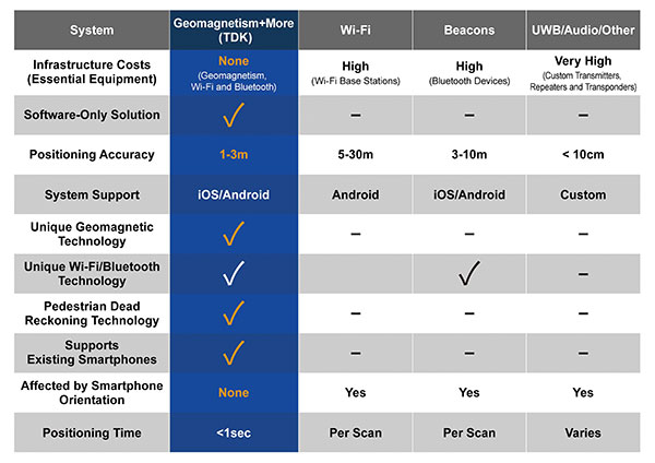
    Comparison of indoor location information technologies. (Chart: Trusted Positioning)
    Comparison of indoor location information technologies. (Chart: Trusted Positioning)

    Real-World Trial Under Way

    Beginning in August, a contact tracing trial among workers is being conducted at TDK’s headquarters in Nihonbashi, Tokyo, using VENUE. Employees carry smartphones with a special app installed, and their positions and movement histories on the floor are combined with anonymous identification information. If an employee is found to be infected, the data will be analyzed to identify people who had contact with that employee within the preceding two weeks, and measures such as stay-at-home instruction will be taken.

    This solution not only can identify those who were in close contact with the infected person as primary contacts, but also trace those who stayed in areas where the infected person had been shortly before as potential “area contacts.” Analysis that combines location and elapsed time enables more effective contact tracing by improving primary contact tracing indoors and enabling area-based contact tracing over time.
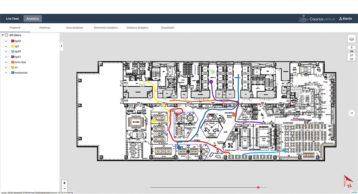
    Ongoing Trial at TDK Headquarters: VENUE displays an individual worker’s tracking data on the dashboard. (Conceptual illustration: Trusted Positioning)
    Ongoing Trial at TDK Headquarters: VENUE displays an individual worker’s tracking data on the dashboard. (Conceptual illustration: Trusted Positioning)
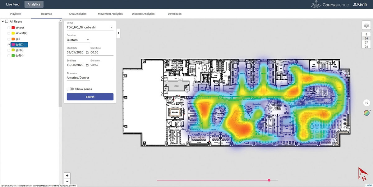
    Ongoing Trial at TDK Headquarters: A worker’s durations of stay and positions can be visualized in the form of a heat map. (Conceptual illustration: Trusted Positioning)
    Ongoing Trial at TDK Headquarters: A worker’s durations of stay and positions can be visualized in the form of a heat map. (Conceptual illustration: Trusted Positioning)

    New Possibilities Opened

    Because VENUE can display the positions and histories of people and objects using not only workers’ smartphones but special tags containing geomagnetic and inertial sensors (under development), it can be deployed for a wide range of applications beyond contact-tracing of infectious diseases. Possible uses include monitoring the flow of employees to improve operational efficiency or tracking positions of equipment to manage their operational statuses. TDK is working with a number of companies on solutions to improve business efficiencies using location information.

    Many offices have introduced open seating, so maintaining a “real-time seating chart” using VENUE is a real advantage so staff can more easily find one another in large office settings, encouraging more collaboration between staff and departments.
    Companies have been using Bluetooth low-energy (BLE) beacons to manage the movement of workers, materials and equipment indoors in warehouses, factories and construction sites. VENUE can reduce the installation and maintenance costs of such systems, especially in large-scale facilities.

    VENUE is also useful for other contact-tracing applications that do not focus on viral transmission, such as human-to-machine, human-to-vehicle and human-to-robot contacts. The future work environment will undoubtedly change with more automation, and the interaction of humans and machines poses safety concerns. VENUE’s designers hope it can improve safety in many types of contact-tracing applications.

    Similar to the expansion of GPS for outdoor positioning applications, indoor positioning technologies will likely grow in our everyday lives. VENUE is one indoor location information solution that enables highly accurate location information to be obtained while keeping infrastructure costs down.


  • Plug-and-play compass selected for survey package

    Plug-and-play compass selected for survey package

    Photo: Advanced Navigation
    Photo: Advanced Navigation

    Advanced Navigation’s plug-and-play GNSS Compass was selected by Nortek for its new survey package. Nortek’s scientific instruments apply the Doppler principle to underwater acoustics to measure water in motion, such as currents and waves. The instruments are used by scientists, researchers and engineers worldwide, employed in demanding environments that require state-of-the-art instrumentation that is reliable and easy to use.

    A vessel-mounted acoustic Doppler current profiler (ADCP) measures the velocity of currents beneath a moving vessel. To correct the measured values for vessel speed and direction, ADCP measurements require accurate velocity and heading information. Besides the use of bottom track within the ADCP itself, such information can be provided externally using a GNSS receiver and a non-magnetic heading source such as a gyro compass.

    Nortek’s ADCP package — Signature VM — offers operational convenience and reduced complexity. As part of the package, Advanced Navigation’s GNSS Compass provides accurate dual-antenna GNSS-based heading that is not subject to magnetic interference. Its inertial navigation system (INS) can maintain accurate heading during GNSS outages of up to 20 minutes. “By making use of today’s modern Ethernet instruments, such as the Signature ADCP and the GNSS Compass, we can guarantee nanosecond time synchronization with Ethernet PTP protocol,” said Herman Huitema, VM product manager at Nortek. “Data from the ADCP can be exactly aligned with the GNSS Compass information.”

  • Water utilities reduce expenses with mobile GIS

    Water utilities reduce expenses with mobile GIS

    GIS Manager Kenny Ratliff, Oldham County Water District, collects utility data. (Photo: Eos Positioning)
    GIS Manager Kenny Ratliff, Oldham County Water District, collects utility data. (Photo: Eos Positioning)

    Across North America, the use of high-accuracy GNSS technology has proliferated among water and wastewater service providers. Water utilities are saving time, cutting operational expenses, and definitively improving the accuracy of their asset management systems by capturing survey-grade location data.

    Oldham County Water District serves more than 8,300 residences with 369 miles of pipeline in rural Kentucky. In 2001, the utility digitized its assets for the first time. In 2016, they decided it was time to improve the assets’ accuracy. GIS Manager Kenny Ratliff deployed ArcGIS Collector, iPad 2 mobile devices, and the Arrow Gold GNSS receiver by Eos Positioning Systems. As a result, OCWD was able to more quickly arrive exactly at the location where meters were to be replaced. With the savings of time, labor and fuel, OCWD cut the cost of installing each water meter by half, from $212 to $111.

    Other water utilities are using GNSS technology to improve the office-to-field workflow, accelerate deployment of new systems, and map buried pipelines.

  • Construction company adopts positioning tech for marine projects

    Construction company adopts positioning tech for marine projects

    Photo: Vladimirovic/E+/Getty Images
    Photo: Vladimirovic/E+/Getty Images

    Offshore construction company Sulmara Subsea has exclusively used Hexagon | VERIPOS solutions since inception to achieve precise, redundant and reliable vessel positioning for a variety of marine construction projects. Projects involving the precise positioning of offshore vessels and subsea assets and vehicles such as ROVs and trenchers are vital to success — even slight errors or loss of connection in surface navigation can lead to problems and down time that can cost millions.

    “Sulmara has set out to be an industry leader in innovation and technology from the start. Key to the success of any project is the ability to achieve accurate and reliable global positioning,” said Cory Goodyear, Sulmara’s Americas business unit director. “The support from Veripos to provide not only a cost-effective but reliable service is vital to our operations.

    “2020 has seen an unprecedented decline in the oil and gas market, and a growing demand for renewable energy,” Goodyear said. “This has created an even larger demand for lower costs and increased reliability in our services. As a new-start survey company with a goal of establishing itself as a serious competitor, positioning services supported by Veripos was the obvious choice.”

    Veripos offers customers several marine receiver options for hydrographic/offshore surveying, dredging, offshore construction, seismic exploration and dynamic positioning. The LD8 ruggedized compact dual-antenna, multi-constellation receiver is best for short-term projects or where space is limited. The larger LD900 can receive Veripos services through a multi-channel L-band demodulator. The multi-constellation receiver is configurable to allow GNSS heading and inertial positioning. It has an intuitive color display for configuration and monitoring. A kit allows the receiver to be installed within vessel equipment racks.

  • UP42 partners with Intermap for high-resolution elevation data

    NEXTMap digital surface model (Image: Intermap Technologies)
    NEXTMap digital surface model (Image: Intermap Technologies)

    The NEXTMap Elevation Data Suite from Intermap Technologies is now offered on the UP42 developer platform for Earth observation data and analytics. UP42 gives users direct access to extensive Earth observation datasets and advanced processing algorithms, and Intermap Technologies, based in Englewood, Colorado, is a provider of geospatial datasets, solutions and software.

    The NEXTMap 3D elevation products are available as digital surface models and digital terrain models at one-, five- and 10-meter resolution. According to Intermap, NEXTMap One offers 1-meter spatial resolution, 1-meter vertical and 3.5-meter horizontal accuracy; NEXTMap 5 offers 5-meter resolution, 1.6-meter vertical and 3.5-meter horizontal accuracy; and NEXTMap 10 offers 10-meter resolution, 8.4-meter vertical and 17.5-meter horizontal accuracy.

    “We are excited to add NEXTMap elevation models to the UP42 platform. Our customers need this data for a range of use cases, including monitoring of vital infrastructure projects such as pipelines, powerlines and railway corridors,” said Sean Wiid, CEO of UP42. “High-quality 3D data is critical in every phase of infrastructure management from construction planning to ongoing monitoring of vegetation encroachment.”

    The addition of NEXTMap datasets to the UP42 marketplace enables users to build even more powerful geospatial solutions in the areas of infrastructure management, construction planning, geologic mapping, land cover classification, forestry, resource conservation and contour generation, UP42 said.

    “Our goal at UP42 is to create a single platform where our users have access to all the geospatial data, analytics and processing infrastructure they need to build solutions that solve critical real world problems,” said Wiid. “Intermap’s NEXTMap elevation models dramatically expand our core data offering and, as a result, expand the range of use cases we can help our customers address.”

    The NEXTMap datasets join a variety of Earth observation information already on the UP42 marketplace, including Pleiades 1A/B, SPOT 6/7, Landsat-8, TerraSar-X, Sentinel-2 and MODIS satellite imagery, Getmapping U.K. aerial data, exactEarth AIS data, and Meteomatics weather and ocean data.

  • Amphibious excavators guided by GNSS in bay cleanup

    Amphibious excavators guided by GNSS in bay cleanup

    Photo: Topcon
    Photo: Topcon

    Over the years, contractors involved in underwater excavation projects — dredging, pond/lake expansions, creation of boat landings, waterfront cleanups, etc. — have become some of the most ardent supporters of GNSS-based solutions. They’ve found that the ability to “see” beneath the surface with their machines has proven invaluable in improving efficiency and minimizing the risk of over/under cutting.

    The Minnesota Department of Natural Resources (DNR) led the effort to remediate a section of the St. Louis River on Duluth’s waterfront. Midwest Amphibious Equipment (MAE) tackled the huge restoration project, equipping two of its amphibious excavators with Topcon HiPer VR, an FC-5000 field controller and an X-53i system.

    MAE began digging out vast amounts of wood waste that had rested at the bottom of the river for more than a century, when sawmills lined the waterfront. By removing the wood waste and building a small island in the Grassy Point area, the DNR hopes to restore the damaged habitat.

    The murky water required a precise method of measuring the cuts as debris was removed. “The Topcon solution lets my guys know exactly where the bucket is in relation to the plan provided by the engineers,” said MAE CEO Steve Gilbertson. “There is no guesswork; it is dead-on every time, with tolerances to 1/10 of a foot — far closer than we need it to be.”

    Topcon’s SiteLink 3D provides a point-to-point communications solution. “With the click of a button I can do everything from verifying a machine’s position to sending the as-built back to the office to looking at their screen to answer a question the operator might have about the project itself,” Gilbertson said. “We’ve only scratched the surface of what can be done with SiteLink, but it’s still proving a really nice addition to our operation.”

    Less than halfway into the project, MAE had removed more than 100,000 cubic yards of material.

  • Launchpad: Government drone, data collectors

    Launchpad: Government drone, data collectors

    A roundup of recent products in the GNSS and inertial positioning industry from the November 2020 issue of GPS World magazine.


    OEM

    GNSS receiver

    Sub-decimeter accuracy without additional service subscription

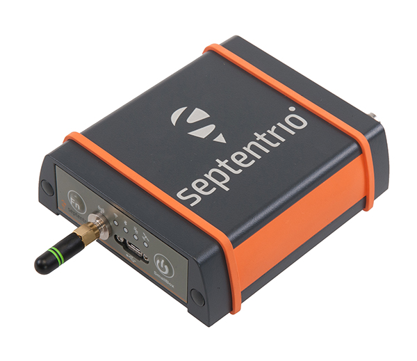
    The AsteRs-m2-Sx. (Photo: Septentrio)
    The AsteRs-m2-Sx. (Photo: Septentrio)

    The SECORX-S product line, which first offered GNSS OEM boards, now also includes a compact mosaic-Sx module and ruggedized receiver in an IP68 chassis, the AsteRx SB Sx. The multi-constellation multi-frequency SECORX-S receivers deliver sub-decimeter positioning without the need for additional correction service subscription or maintenance. The PPP-RTK correction service is integrated directly into Septentrio’s core GNSS technology. The addition of modules and boxed receivers to the SECORX-S line providesz accurate positioning to applications such as precision agriculture, UAVs, robotics and construction.

    Septentrio, septentrio.com

    GNSS splitters

    Improve service reliability

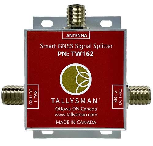
    Photo: Tallysman
    Photo: Tallysman

    Smart Power GNSS signal splitters improve GNSS service reliability and minimize service interruptions. The professional-grade splitters — TW162 (one antenna/two receivers) and TW164 (one antenna/four receivers) — offer system redundancy and fail-over capability. The splitters are designed to improve GNSS service reliability and reduce signal reception failures. Both splitters offer system redundancy and fail-over capability. They support GPS/QZSS-L1/L2/L5, QZSS-L6, GLONASS-G1/G2/G3, Galileo-E1/E5a/E5b/E6, BeiDou-B1/B2/B2a/B3 and L-band correction services.

    Tallysman, tallysman.com

    5G modules

    Ready for 5G platforms

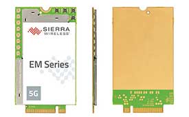
    Photo: Sierra Wireless
    Photo: Sierra Wireless

    The EM919x 5G NR Sub-6 GHz and mmWave embedded modules include an integrated GNSS receiver. Based on the industry-standard M.2 form factor, the modules will enable original equipment manufacturers (OEMs) to securely deploy 5G connectivity worldwide at the highest possible speeds with ultra-low latency for routers and gateways. The modules support mmWave, sub-6 GHz and LTE, as defined by the 3GPP Release 15 standard. Applications include private networks, enterprise networking, edge processing, live streaming, video security, e-gaming, smart factories, robotics, drones, virtual reality, machine learning, and new Industrial IoT applications.

    Sierra Wireless, sierrawireless.com

    GNSS/IMU series

    Tactical-Grade Inertial Positioning

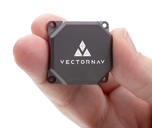
    Tactical Embedded series of GNSS/IMUs. (Photo: VectorNav)
    Tactical Embedded series of GNSS/IMUs. (Photo: VectorNav)

    The Tactical Embedded series of GNSS/IMUs feature a tactical-grade inertial measurement unit (IMU) and a multi-band GNSS receiver. The line delivers milliradian attitude accuracy and centimeter-level positioning capability in a miniature 15-gram package. The small size enables cost reductions for a range of autonomous pointing and geo-referencing applications such as gimballed intelligence, surveillance and reconnaissance (ISR); satellite communication systems; lidar mapping; and photogrammetry. The line supports external SAASM GPS for defense applications in ISR, electronic warfare, munitions and UAV navigation. The line includes the VN-110E IMU/AHRS, the VN-210E GNSS-aided inertial navigation system (INS), and the VN-310E dual-antenna GNSS/INS.

    VectorNav Technologies, vectornav.com

    GNSS/INS Sensor

    Designed for dynamic environments

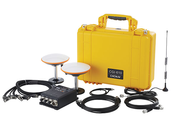
    Photo: CHCNAV
    Photo: CHCNAV

    The CGI-610 GNSS/INS high-precision dual-antenna receiver offers reliable and accurate navigation and positioning for demanding land, marine and aerial applications. The tight fusion of the latest GNSS technology with an industrial-grade MEMS IMU is powered by CHCNAV’s algorithms to deliver accurate hybrid position, attitude and velocity data, even in complex and obstructed environments where GNSS outages can occur. The CGI-610 supports data output up to 100 Hz to meet the requirements of highly dynamic applications such as airplane, train and automobile. An optional external odometer sensor for ground vehicles can provide an additional measurement of displacement and speed, which is fused with the GNSS/INS navigation solution.

    CHC Navigation, chcnav.com


    SURVEYING & MAPPING

    GNSS receiver

    Scalable-accuracy, survey-grade receiver

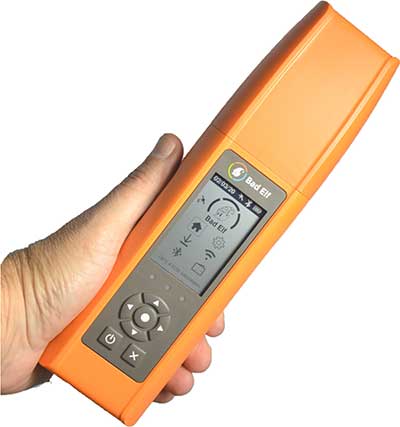
    Photo: Bad Elf
    Photo: Bad Elf

    Bad Elf Flex is a scalable-accuracy GNSS receiver with a daily option to choose between L-band and real-time kinematic (RTK). In standard configuration, it achieves 30-60 cm accuracy in real time for GIS use. Consuming a Bad Elf Flex Token unlocks a full RTK workflow for a 24-hour period to deliver 1-cm horizontal accuracy. Bad Elf Flex stores the tokens directly on the receiver, making them available for use anytime. Customers requiring high accuracy at all times can purchase the Bad Elf Flex Extreme bundle, with RTK capabilities permanently unlocked, for a one-time upgrade fee.

    Bad Elf LLC, bad-elf.com

    Data Collector

    With integrated autofocusing camera

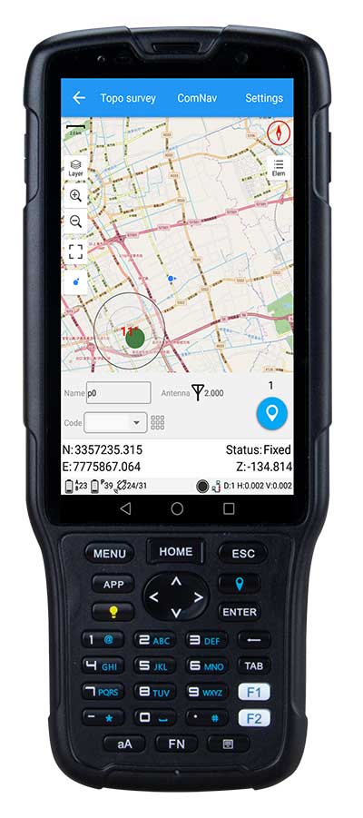
    Photo: ComNav
    Photo: ComNav

    The R550 data collector features an industrial-level design and new hardware platform to ensure efficiency and productivity in the field. The IP67 dust-and-waterproof rating protects the R550 from most harsh environments. Equipping it with a 7,000 mA Li-ion battery allows more than 14 hours of continuous operation, while fast-charging technology means four hours for a full charge. The 5-inch-wide sunlight-readable, high-resolution screen provides a smooth experience for any operation. The integrated autofocusing camera helps enhance job documentation by taking photos on site and sharing job information with colleagues. Survey Master field software available on the R550 controller ensures efficient surveys in the field, including topographic surveys, stakeouts, coordinate geometry (COGO) and more. Powered by the Android 8.1 operating system and designed with 4G RAM, 64GB ROM and 4G/BT/Wi-Fi on board, users can run other third-party apps based on their specific requirements.

    ComNav Technology, www.comnavtech.com


    UAV

    OEM board

    Provides georeferencing of airborne data

    Photo: Applanix
    Photo: Applanix

    The Trimble AP+ Air OEM solution provides direct georeferencing of airborne sensor data and enables users to accurately and efficiently produce maps and 3D models without the use of ground control points. It is designed for manned platforms, yet small enough for use on UAVs. It is also compatible with airborne remote sensors, including photogrammetric cameras, lidar, hyper- and multi-spectral cameras, and synthetic aperture radar. The Trimble AP+ Air features dual embedded survey-grade GNSS chipsets, an onboard inertial measurement unit (IMU), an external IMU, and the new Applanix IN-Fusion+ GNSS-aided inertial firmware. It is configurable to support the direct georeferencing accuracy demands of low-flying UAVs and high-altitude manned platforms. Trimble AP+ Air is supported by Applanix POSPac MMS post-processing software with CenterPoint RTX post-processing for centimeter-level positioning anywhere in the world without the need for base stations.

    Applanix, applanix.com

    Drone for Government

    American-made drone aimed at government agencies and military

    Photo: Teal
    Photo: Teal

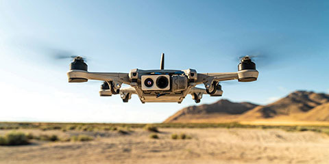
    The Teal Golden Eagle drone is designed for short-range surveillance and reconnaissance missions. It features a FLIR Handron dual-camera sensor on a two-axis stabilizer, giving it color vision at 4K 60 fps and thermal vision for extended operations. The payload is hot-swappable. It has a flight time of up to 50 minutes and can fly at speeds of 50 mph with a range of 2 miles. It is able to fly in wind speeds of up to 30 mph and can operate between –32° and 110° Fahrenheit. Forward-facing obstacle avoidance and rear-facing visual-inertial odometry estimates location without the need for GPS. The platform has received approval from the Department of Defense.

    Teal, tealdrones.com


    TRANSPORTATION

    Antennas

    Aimed at autonomous vehicle market

    Photo: Tallysman
    Photo: Tallysman

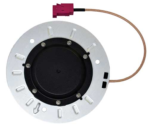
    A new line of AccuAuto triple-band antennas are designed to provide strong clean code and phase signals to enable high-precision real-time kinematic (RTK) and precise point positioning (PPP) navigation. Model TWA928 supports GPS/QZSS-L1/L2/L5, GLONASS-G1/G2/G3, Galileo-E1/E5a/E5b, BeiDou-B1/B2/B2a and NavIC-L5 signals and frequency bands (the TWA928L includes support for L-band correction services). The AccuAuto line features patented Accutenna technology multi-constellation and multi-frequency antenna elements as well as an integrated ground plane, a radome and an underside cover that provides mist and condensation protection. A deep pre-filter minimizes out-of-band noise and maximizes in-band reception. All AccuAuto components are certified and designed to perform under challenging environmental conditions, such as extreme temperatures (–40° C to +125° C), shock and vibration.

    Tallysman Wireless, tallysman.com

    Navigation system

    Defense small-vehicle system designed for export

    Photo: Etion Create
    Photo: Etion Create

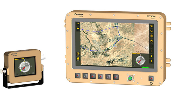
    The CheetahNAV provides situational awareness for harsh environments and battlefield conditions, providing the crew of a light military vehicle with highly accurate position information through an advanced inertial measurement system (IMS) comprising several aids, including a gyro-compensated compass and an advanced Kalman-filter-based algorithm. The system provides dead-reckoning horizontal position accuracy of 0.2% of distance traveled in a GNSS-denied situation — accuracy of 200 meters over 100 kilometers. It can integrate with inertial navigation systems (INS). Combined with GNSS and compass information, the system enables dead-reckoning and accurate positioning of the vehicle in tactical situations. The tactical-grade integral inertial measurement unit (IMU) ensures jam-free operation.

    Etion Create, etion.co.za/create/

  • CGI to develop service to alert UK of GNSS disruption

    CGI to develop service to alert UK of GNSS disruption

    The European Space Agency (ESA) has awarded a contract to London-based CGI to develop a GNSS Event Notification Service (GENS) capable of monitoring the United Kingdom (U.K.) GNSS spectrum to enable effective alerting and reporting of position, navigation and time (PNT) disruption.

    GENS will integrate CGI’s PNT Incident Event Monitoring (PNTIEM) system with existing U.K.-developed sensors from Ordnance Survey’s network (OS NET) of GNSS receivers and GMV NSL’s Detector, GISMO and Strike 3 interface technologies.

    Bringing together existing systems will build on proven technologies, reducing the cost of development of a large-scale monitoring network while providing the ability to introduce new services for detecting GNSS events and disruption, according to a CSI press release.

    Supported by the OS and GMV NSL, CGI will lead the delivery of GENS using an agile software delivery experience, supported by system design and DevSecOps development and integration skills. An open interface will be offered for future providers of GNSS measurements or spectrum event data.

    Alongside the GENS system technical delivery, the National Physical Laboratory (NPL) will develop a GNSS guidance document in partnership with U.K. government departments, agencies, CNI operators, professional institutes, academic institutes and commercial organizations to enable informed requirements development, procurement, deployment and support of HMG GNSS-reliant services.

    Reviewed alongside events identified by GENS, the combined offering will highlight and inform stakeholders on risks posed by the loss of PNT services as identified by the PNT Strategy Group Interim Report in April 2020.

    GENS will also respond to HMG’s “Satellite-derived time and position: a study of critical dependencies” report which identified the need for mitigation to GNSS disruption and estimated the economic impact to the U.K. economy of a five-day disruption to GNSS at £5.2 billion.

    The full GENS system will enable users across both commercial and public sector services to subscribe to be informed of both GNSS quality and interference events for regions of interest. By focusing on these events and the improved understanding of the risk posed by disruption, stakeholders will be better informed to enable them to build system resilience or to respond to the disruption of GNSS within the U.K.

    ‘‘Detecting and monitoring GNSS is core to better understanding the scale and risk posed by PNT disruption in the U.K. and across all ESA member states,” said Rafael Lucas Rodriguez, technical officer for GENS, European Space Agency. “ESA is supporting CGI to develop effective tools enabling a system to be created utilizing previous ESA and UK HMG work. This will bring direct benefits for U.K. public and private stakeholders.”

    “The U.K. is a leading investor in GNSS research,” said Andy Proctor, U.K. lead delegate to the ESA Programme Board for Navigation. “Understanding GNSS spectrum quality is vital for the stability of PNT services in the U.K. This program will help promote and address GNSS disruption affecting PNT services while supporting the U.K.’s thriving space sector and the wider economy.”

    “This is an exciting project that brings together CGI’s navigation and spectrum domain expertise supported by scaled agile and DevSecOps delivery experience,” said John Hanley, vice president of secure and assured space solutions at CGI in the U.K. “After talking to both public and private stakeholders for GNSS, it became clear that one of the initial challenges is understanding the scale of PNT disruption. GNSS services touch every part of society across finance, utilities, transport and defense and need to be protected.”

    CGI has been delivering complex, mission-critical space software systems for clients across Europe, Asia and North America, supporting satellite navigation, communications, operations and space enabled applications for more than 40 years.


    Feature photo: alice-photo/iStock/Getty Images Plus/Getty Images

  • Emcore’s EN-300 FOG IMU in high-rate production

    Emcore’s EN-300 FOG IMU in high-rate production

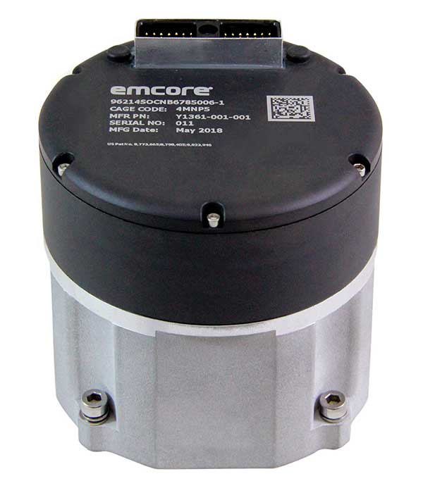
    EN-300 Precision Fiber Optic IMU/INS (Photo: Emcore)
    EN-300 Precision Fiber Optic IMU/INS (Photo: Emcore)

    Emcore Corp.’s EN-300 FOG (fiber optic gyro) inertial measurement unit (IMU) is now in high-rate production and is broadly available for purchase with 12-week lead times. The EN-300 was announced in April.

    Based in Alhambra, California, Emcore providees advanced mixed-signal products that serve the aerospace, defense and broadband communications markets.

    Emcore’s EN-300 offers up to 10 times the bias performance of legacy systems in a form, fit and function compatible package, the company said. This improved performance makes the EN-300 suitable for GPS-denied navigation, precise targeting and line-of-sight stabilization requirements for unmanned aerial vehicles as well as other demanding applications.

    Emcore has successfully completed a comprehensive Design Verification Testing (DVT) regimen over tough environmental conditions and has provided numerous proof-of-technology IMUs globally to defense contractor primes and aerospace customers seeking to upgrade their platforms and systems. Emcore is now expanding production of the EN-300 with strict manufacturing process and quality controls in place to enhance on-time delivery and specification compliance.

    “Given the strong market interest and demand, we are extremely pleased to announce the production ramp-up and broad availability for purchase of the EN-300,” said David Hoyh, Emcore’s director of sales & marketing for navigation products. “Emcore’s vertical integration creates unique capabilities that enable us to deliver the higher level of performance demanded by the market, coupled with greater precision and lower cost to further benefit our customers.”

    According to Emcore, the EN-300 precision FOG IMU is a three-axis, closed-loop design using the Company’s proprietary, solid-state FOG transceiver with advanced integrated optics, offering improved reliability and lower cost than legacy IMUs. It can be ordered with performance options tailored to specific customer requirements.

    The COTS (commercial off-the-shelf) EN-300-3 model achieves bias in-run stability as low as 0.04 degree/hr with ARW (Angle Random Walk) of 0.015 degree/rt-hr. The non-ITAR EN-300 is superior in performance to older generation such as the closed-loop LN-200 IMU or open-loop KVH 1750 series IMU units that have higher bias over temperature drift.

  • Inertial Labs launches Kernel-100 IMU with MEMS sensors

    Inertial Labs launches Kernel-100 IMU with MEMS sensors

    Photo: Inertial Labs
    Photo: Inertial Labs

    Inertial Labs is offering a new industrial-grade inertial measurement unit (IMU) for aerospace and defense applications, among others.

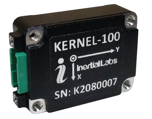
    The Kernel-100 is a compact, self-contained strapdown IMU that measures linear acceleration and angular rates with three-axis MEMS accelerometers and three-axis MEMS gyroscopes.

    The Kernel-100 is fully calibrated, temperature compensated, mathematically aligned to an orthogonal coordinate system. It contains up to 2 deg/hr bias in-run stability gyroscopes and 10 μg bias in-run stability accelerometers with extremely low noise and high repeatability.

    The Kernel-100 is a fully integrated inertial solution that includes the newest MEMS sensor technologies. With seamless integration, the Kernel-100 inertial system is a cost-effective high performance yet compact and low-power IMU, the company said. The Kernel-100 is easy to integrate in a wide range of higher order systems while consuming very little space and power.

    With continuous built-in test (BIT), configurable communications protocols, electromagnetic interference protection, and flexible input power requirements, the Kernel-100 is built to be used in a wide variety of environments and integrated system applications.

    Built for air, marine and land environments, the Kernel-100 can be integrated into motion reference units, attitude and heading reference systems, and GPS-aided inertial navigation systems. As a result, the Kernel-100 is suitable for a wide variety of applications such as autonomous vehicles, antenna and line-of-sight stabilizations systems, and buoy or boat motion monitoring.

    Inertial Labs provides innovative solutions to commerce, industry and government for defense and aerospace.

  • Swift Navigation’s SSR service now available across 2 continents

    Swift Navigation’s SSR service now available across 2 continents

    Image: Swift Navigation
    Image: Swift Navigation

    Swift Navigation has launched its production-grade SSR (state space representation) service across Swift’s coverage areas.

    Swift is a San Francisco-based tech firm offering GNSS and precise positioning technology for mass-market applications in autonomous vehicles, mobile and internet of things (IoT).

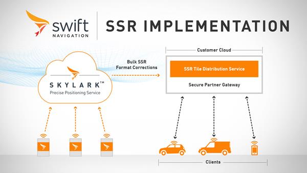
    SSR is a bandwidth-efficient format to deliver GNSS corrections to mass-market applications, such as for automotive and mobile customers. It is offered through Swift’s Skylark precise positioning service.

    As a new option for corrections delivery available as part of Swift’s precise positioning service, SSR delivers seamless and homogeneous accuracy throughout a coverage area. To date, Skylark delivered corrections in OSR (observation state representation) format for compatibility with legacy equipment but with the introduction of SSR, the power of Swift’s cloud error modeling is now available in its native format.

    SSR provides users with fine-grained information about GNSS error sources. SSR divides the coverage region into a series of “tiles” which can be broadcast to all users within that tile, enhancing scalability and minimizing bandwidth while maintaining the utmost security and privacy.

    With the capacity to reach millions of connected devices in markets such as mobile and automotive, it is critical to provide both a scalable and secure solution. Swift’s Skylark can deliver bulk corrections data to enterprise customers’ backend for distribution, putting the customer in control of their own users’ privacy and security.

    Swift’s enterprise-reference architecture code equips customers with the SSR Tile Distribution Server software that provides a seamless integration path to incorporate SSR corrections into their own cloud or on-premise solution.

    Swift’s SSR solution is also based on the open standard from 3GPP. The significance of utilizing the SSR positioning standard from the 3GPP standards body is that it meets the interoperability requirements demanded by mass-market mobile and automotive applications.

    “The team at Swift is excited to bring its production-grade, standards-based SSR service to market,” shares Fergus Noble, CTO at Swift Navigation. “The ability to deploy SSR to users in a scalable way, while maintaining privacy, makes it possible for automotive, cellular and IoT mass-market customers to integrate precise positioning into their service offering.”

    Skylark is available for integration into wide-area, high-precision positioning applications across the continental United States and Europe and is available in the countries of Japan, South Korea and Australia, with plans to expand globally. Skylark is an ever-expanding service and is scalable to service millions of users. All eligible Skylark subscribers begin with a free trial or pilot program.

  • U-blox provides LPWA IoT security to system engineers

    U-blox provides LPWA IoT security to system engineers

    Image: metamorworks/iStock/Getty Images Plus/Getty Images
    Image: metamorworks/iStock/Getty Images Plus/Getty Images

    U‑blox has launched a commercial internet of things (IoT) Security-as-a-Service offering. Available on both the u‑blox SARA-R4 and SARA-R5 series of LTE-M cellular IoT modules, the service protects data from malicious third parties, both on the device and during transmission from the device to the cloud, u-blox said in a press release.

    Both the SARA-R4 and R5 have integrated M8 GNSS receivers.

    The IoT Security-as-a-Service provides an out-of-the box onboarding process to cloud IoT platforms to speed up development, shortening time-to-market.

    The IoT Security-as-a-Service offering, which is managed via the u‑blox Thingstream service delivery platform, is specifically optimized for low-power, wide-area (LPWA) deployments that use resource-constrained IoT devices. By substantially reducing data overhead and keeping the number of handshakes to a minimum, the service improves power consumption and extends the battery life, a critical metric for most IoT devices.

    u-blox acquired Thingstream, an IoT communication-as-a-service provider, in April.

    Central to the effectiveness of the solution is a unique symmetric key management system (KMS). Through it, an infinite number of crypto keys can be generated on the fly for each device, rather than having to rely on the storage and management of pre-shared keys (which can add to overall operational complexity and the power budget).

    Keys are tied to the hardware and can be triggered from either the module or from the server/cloud, completely eliminating the need to create, deliver, and renew certificates, and bringing significant savings in terms of system cost, operational complexity, and power consumption.

    The solution also leverages u‑blox’s Foundation security offering, which comprises fundamental elements that make SARA-R4 and SARA-R5 modules secure by design. These include a unique and immutable device identity that is tied to its root of trust (RoT), which forms the basis for a trusted set of advanced security functionality, including a secure boot mechanism that ensures that the module can only run trusted software. In addition, u‑blox’s proprietary uFOTA feature enables authentication of over-the-air firmware updates.

    Among the relevant use cases that u‑blox IoT Security-as-a-Service can support are:

    • Asset tracking. Data authenticity is essential in such scenarios, as well as secure local storage of collected data and easy secure cloud onboarding. Because tracking devices are usually battery powered, they require extremely energy-efficient secure data transmission.
    • Connected health/eHealth. In this use case, patient confidentiality is paramount, with only authorized medical staff permitted to access sensitive data. This necessitates a high degree of protection against malware and data tampering.
    • Industrial monitoring. These solutions need to guarantee the integrity of real-time operational data to increase productivity, avoid downtime, and assure the safety of the workforce.
    • Building and home automation. Data confidentiality and authenticity need to be maintained, while allowing for data to be shared with trusted stakeholders without compromising customer privacy.
    • Telematics. In this scenario, the main security risks include denial-of-service (DoS) attacks, device cloning, jamming, etc.
    • Smart metering. Here, the authenticity of data logged by remote metering units needs to be confirmed to protect billing, and, once trusted communication is established, data transmission needs to be restricted to authorized servers.

    “We implemented a true end-to-end concept that protects data from the device to the end user without making it visible to intermediate nodes or platforms, or to service providers. The modules’ symmetric KMS offers engineers a streamlined and scalable alternative to conventional public key infrastructure or pre-shared key arrangements,” says Giovanni Solito, senior product manager, Product Center Services at u‑blox. “And with straightforward onboarding to all the popular cloud IoT platforms, efforts are not taken up by security concerns and operational complexities, but can be focused on speeding up time to market and growing business.”