SMC awards multiple rapid prototyping agreements for joint modernized GPS handheld device; four demonstrations to be held
The Defense Advanced GPS Receiver (DAGR) in use in 2011. (Photo: U.S. Army)
On June 26, the United States Space Force’s Space and Missile Systems Center awarded three separate rapid prototyping agreements to Collins Aerospace, Raytheon Intelligence & Space and the Technology Advancement Group for a total of $41.1 million.
The firm-fixed price agreements are for the development of a basic working prototype of the joint modernized GPS handheld device. The contract provides the government with innovative solutions demonstrated via hardware and software prototype development.
The purpose of this rapid prototyping effort is to produce a joint modernized handheld smaller in size with low power consumption, increased military-code capability, and improved anti-jamming and anti-spoofing capabilities compared to the equipment now used by the military.
4 demonstrations coming
This is the second competitive objective under the current Phase I strategy and is the result of a down-select from five to three vendors. It builds off the first objective of Phase I, which focused on mock-ups and drawings.
These agreements provide for four demonstrations to be held with Army and Marine Corps representatives. The demonstrations give the end users an early opportunity to provide feedback and the ability to influence the final design — ultimately making for a more seamless transition to operations.
“This is the first major update to the military’s GPS handheld device in more than 15 years,” said Col. Clifford Sulham, User Products Division chief. “The advanced capabilities of this device will allow our airmen, soldiers, sailors and Marines to conduct operations in GPS-challenged environments.”
Trimble GNSS integrates with PointMan field applications to identify, capture and record the precise geospatial location of utilities
ProStar has joined Trimble’s GIS Business Partner Program. As part of the program, ProStar has implemented the Trimble Precision SDK (software developer kit) to integrate high-accuracy positioning capability in its PointMan mobile application running on smartphones and tablets using Trimble GNSS receivers.
ProStar provides field crews with an easy-to-use mobile data collection solution designed to capture, record and provide real-time visualization of the precise locations of subsurface infrastructure, while utilizing a centralized database to permanently and securely store and share utility location records in the cloud.
By adding the Trimble R Series and Trimble Catalyst receivers to the ProStar workflow, users can confidently access high-quality data and identify potential conflicts to avoid accidents, disruption of services and costly delays to infrastructure projects impacted by not knowing the precise locations of buried utilities.
“Together, Trimble and ProStar are changing the way construction companies, engineering and surveying firms as well as government transportation agencies capture, store and utilize utility infrastructure data. By leveraging the power of geospatial technology, they are able to make more informed decisions in the field,” said Stephanie Michaud, strategic marketing manager, Trimble Survey & Mapping field solutions. “Through this collaboration with ProStar, we are committed to integrating Trimble technology into ProStar’s cloud and mobile solutions to enhance safety protocols on site, reduce project costs and make a safer work environment.”
“We’re excited about this new collaboration and the integration of our PointMan software with Trimble’s high-accuracy GNSS receivers,” said Page Tucker, president & CEO of ProStar. “Creating a seamless integration with Trimble high-accuracy receivers and our PointMan software is a game-changer that will now provide one of the most comprehensive and precise field data collection solutions in the industry.”
About ProStar
ProStar specializes in the development of Precision Mapping Solutions. ProStar’s Solution is natively cloud and mobile and offered as Software as a Service.
ProStar’s Solution is designed to improve the business operations of any industry that requires the precise location of sub-surface infrastructure including utility, oil & gas, construction, engineering & surveying, 811 and contract locating.
ProStar’s Solution enables real-time access to precise location information including in the office and out in the field. Knowing the type, precise location and condition of what lies below the earth’s surface can significantly decrease liabilities and increase productivity during construction and maintenance activities.
Representatives from Fuyao Glass visited Harxon’s Shenzhen, China, headquarters on July 1. (Photo: Harxon)
Fuyao Glass Industry Group Co. Ltd. and Harxon Corporation have established a partnership to develop an advanced smart conformal antenna with automotive glass. Representatives from Fuyao Glass visited Harxon’s Shenzhen, China, headquarters on July 1.
According to the agreement, Harxon will specifically study the pass-through characteristics of high-frequency signals, and develop revolutionary automotive antennas based on the material and manufacturing craftsmanship of Fuyao Group automotive glass.
Both parties will establish a joint innovation team to research and develop a smart, multi-band conformal automotive antenna that integrates radio services with Fuyao’s smart automotive glass technology.
By combining the automotive glass and the antennas into one package, automakers capture immediate benefits of cost reduction, reduced installation complexity, and improved reliability.
Founded in 2008, Harxon Corporation (a BDstar company) is a customer-focused enterprise carrying out innovative research, manufacturing and marketing in high-precision GNSS antennas, ultra-reliable wireless data transmission radio modems, and smart antennas. Applications include surveying, precision agriculture, UAVs and automotive vehicles.
Fuyao Glass was founded in Fuzhou, China, in 1987. It is a multinational company specializing in the manufacture of automobile safety glass and industrial technical glass.
Intergeo 2020, originally slated to take place Oct. 13-15 in Berlin, Germany, will now take place entirely virtually. Organizers announced in early June that the show would take place partially in person and partially virtually.
“Due to international travel restrictions, the protection of risk groups and the limited possibilities of people coming together in enclosed spaces, the Intergeo 2020 in its diversity and size is not feasible under the usual circumstances,” organizers said in an email to registrants.
Berlin recently reduced the number of participants of indoor events to 1,000 people, making the show — which attracted more than 20,000 participants in 2019 — unfeasible.
Now called INTERGEO 2020 Digital, the conference will facilitate the transfer of knowledge and exchange of ideas as well as providing “accessibility and opportunity to drop in at the exhibitors.”
Orolia, through its Orolia Government Systems business, has been selected by Raytheon Missiles & Defense to support the U.S. Lower Tier Air and Missile Defense Sensor (LTAMDS) radar program with its low SWaP (size, weight and power), rugged time and frequency system.
Defeating hypersonic weapons
An artist’s rendering of the Lower Tier Air and Missile Defense Sensor (LTAMDS), a next-generation radar meant to help defeat advanced threats like hypersonic weapons. (Image: Raytheon/Orolia)
The LTAMDS system — an advanced air and missile defense radar — will help the U.S. Army defeat advanced threats, including hypersonic weapons. It is a radar designed to defeat advanced and next-generation threats including hypersonic weapons, or those that fly faster than a mile a second.
LTAMDS has three antenna arrays — a primary array on the front, and two secondary arrays on the back. They work together, detecting and engaging multiple threats from any direction at the same time. This results in a battlefield without blind spots, according to Raytheon.
LTAMDS’ primary array is about the same size as the array for the Patriot Air and Missile Defense System, but it has more than twice the power. It is designed for the U.S. Army’s Integrated Air and Missile Defense system, but it will also preserve existing military customers’ investment in the Patriot system.
Raytheon Missiles & Defense was selected by the United States Army in October 2019 to provide the next-generation LTAMDS.
Timing from Orolia
Orolia was chosen for the LTAMDS program based on its core expertise in resilient timing and configurable ruggedized PNT systems for challenging environments, together with its proven track record of successfully delivering time and frequency platforms for other Raytheon Programs of Record.
Orolia was the first company to receive approval for a time and frequency reference system on the Defense Information Systems Agency (DISA) Department of Defense Information Network (DoDIN) Approved Products List for network interoperability, with its flagship SecureSync system.
“Ultra-precise mission timing and sync technology are fundamental building blocks for the Resilient PNT systems that warfighters rely on for continuous operations in contested environments,” said Hironori Sasaki, president of Orolia Defense & Security. “We are proud to be a Raytheon Missiles & Defense partner on LTAMDS and other programs that utilize GPS signals for timing, frequency and network synchronization across critical military systems.”
From critical timing solutions to GPS/GNSS simulation, interference detection, and mitigation, Orolia is an industry leader in end-to-end NAVWAR and Resilient PNT solutions to protect, augment and strengthen military systems for GPS-denied environments.
Orolia Defense & Security provides resilient PNT solutions and custom engineering services to U.S. government agencies, defense organizations, and their contractors, and is authorized to work on the full spectrum of U.S. government classified and unclassified projects.
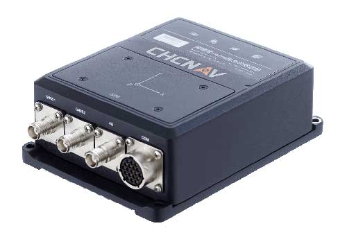
CHC Navigation has released the new CGI-610 GNSS/INS sensor, a high-precision dual-antenna receiver offering reliable and accurate navigation and positioning solutions for demanding land, marine and aerial applications.
The tight fusion of the latest GNSS technology with an industrial-grade MEMS IMU is powered by CHCNAV’s algorithms to deliver accurate hybrid position, attitude and velocity data, even in complex and obstructed environments where GNSS outages can occur.
The CGI-610 is a powerful GNSS/INS system supporting data output up to 100 Hz to meet the requirements of highly dynamic applications (including airplane, train and automobile). The optional external odometer sensor for ground vehicles can provide an additional independent measurement of displacement and speed, which is fused with the GNSS/INS navigation solution.
“The CGI-610 GNSS/INS sensor is the perfect answer to the growing demand of robust positioning and navigation systems for the control of any unmanned vehicle and machine, as well as for highly dynamic applications,” said George Zhao, CEO of CHC Navigation. “Industrial system integrators in need of a reliable GNSS/INS sensor with an exceptional price/performance ratio would definitely consider our CGI-610.”
With its 4G modem, CAN and serial ports, the CGI-610 GNSS/INS sensor offers unparalleled compatibility to enable a wide range of applications including machine control, port automation, advanced trajectography, robotics and unmanned vehicles. The CGI-610’s industrial design ensures reliable and consistent operation in the harshest environments.
Not surprisingly, the primary topic at the July 1 meeting of the National Space-based Positioning, Navigation and Timing Advisory Board was the Federal Communications Commission (FCC) decision on Ligado Networks.
In it Captain Sullenberger cited many of the issues the board’s vice chair, Brad Parkinson, discussed later in the meeting. Sullenberger’s statement is available here.
In his presentation, Parkinson called the FCC decision “a grave error.” He outlined his rationale in 21 information-packed slides.
Parkinson summarized his presentation up front with three points:
Repurposing the Mobile Satellite Services (MSS) radio spectrum is very high risk and brings virtually no near-term benefit to the United States.
The risks affect much more than the Department of Defense: high-value civil applications are also in jeopardy.
Any such repurposing should have been subject to a formal rulemaking process.
At the end of the presentation, the board voted unanimously to adopt the presentation, with slight modifications, as a reference document for posting on the board’s website.
The group had previously made strong recommendations to the Departments of Defense and Transportation to oppose any such action by the FCC. Both departments have done that and are continuing to do.
Hazardous information versus losing lock
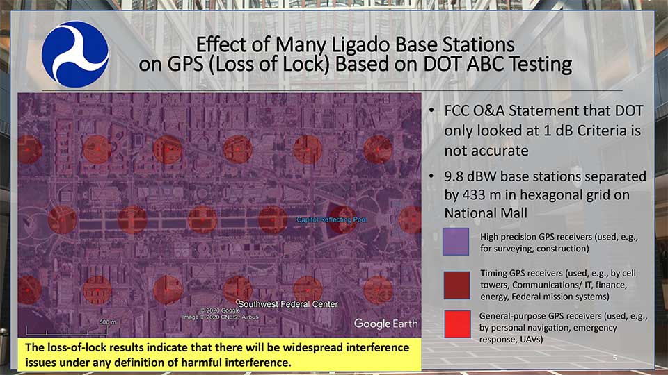
One slide in Parkinson’s presentation included a Department of Transportation (DoT) depiction how of Ligado transmissions would cause several types of receivers to “lose lock.” This graphic was used in a recent DoT presentation to the FCC.
DOT briefing to FCC: “Concerns Over Ligado Order & Authorization,” June 2020. (Slide: DOT)
Heretofore DoT has usually discussed the points at which Ligado transmissions would cause a 25% increase in the noise floor for receivers. This is an important metric as tests have shown that beyond that point many receiver types begin to give hazardously misleading information. DoT officials have used the example that the 1dB limit is like putting a load limit on vehicles crossing a bridge so that the bridge never reaches its breaking point. An important consideration with a safety-of-life application like GPS.
The National Space-Based PNT Advisory Board. (Board photo)
A receiver often gives inaccurate positioning and timing data, possibly hazardously misleading information, before it “loses lock” and stops providing any information at all. It is more difficult for a receiver to “acquire lock” than to track satellites and provide information, so equipment is rarely able to function again until it moves out of the area of interference.
When asked why DoT would bother to show such information to the FCC, one official suggested that loss of lock was more in line with the criteria the Commission used in making the Ligado decision. The hope was that, by showing that even this flawed standard had significant impacts which the FCC perhaps did not fully recognize, further technical discussions and reconsiderations could be realized.
Other Topics
While discussion of the FCC’s decision took the most time in the on-line meeting, several other issues were discussed as well.
Colonel Curtis Hernandez from the National Security Council briefly described development of a new space-based PNT policy to replace NSDP-39 which was put in place by President Bush in 2004.
He was not able to provide any specifics as it is a draft and still under consideration. Answering a question, he did say that the draft policy outlined the responsibilities of various departments, including for interference detection and monitoring.
Adam Balkcum from the Office of Science and Technology Policy discussed his office’s nascent efforts to investigate non-GNSS PNT as directed by the recent Executive Order on Responsible Use of PNT. The question of whether this includes possible PNT services from low earth orbit and geostationary satellites remains an open one.
Other presenters included:
Seth Jonas of the National Security Council staff on the recent Executive Order on Responsible Use of PNT,
Andrew Hansen of the Volpe Transportation Systems Center who spoke about efforts to monitor for GPS interference, especially in the post-FCC Ligado decision environment, and
NASA’s Chris Bonniksen discussed issues with operating and funding the agency’s Global Differential GPS system.
The agenda for the meeting and presentations are available here, as will be the meeting minutes once they have been finalized.
Third Lockheed Martin-Built GPS III satellite climbs to orbit on its own power
GPS III SV03 increases number of secure military code (M-code) enabled satellites in GPS constellation to 22 total.
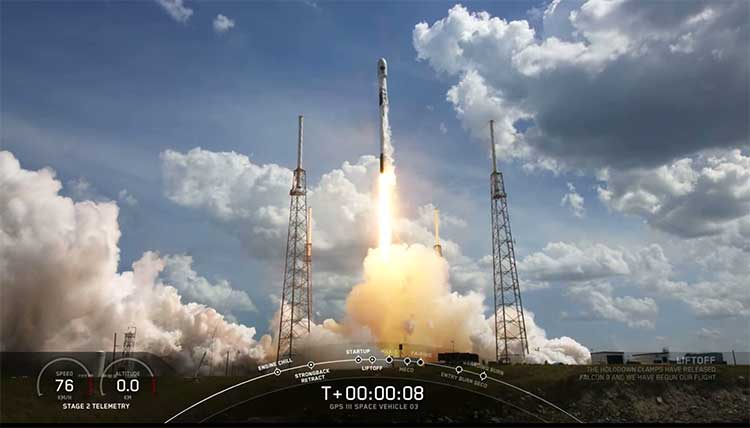
After a successful launch on June 30, the third Lockheed Martin-built GPS III satellite headed to orbit under its own propulsion. The satellite separated from its rocket and used onboard power to climb to its operational orbit, approximately 12,550 miles above the Earth.
GPS III Space Vehicle 03 is responding to commands from U.S. Space Force and Lockheed Martin engineers in the Launch & Checkout Center at the company’s Denver facility. There, they declared rocket booster separation and satellite control about 90 minutes after the satellite’s June 30 launch aboard a SpaceX Falcon 9 rocket from Cape Canaveral Air Force Station, Florida.
“In the coming days, GPS III SV03’s onboard liquid apogee engines will continue to propel the satellite towards its operational orbit,” said Tonya Ladwig, Lockheed Martin’s acting vice president for Navigation Systems. “Once it arrives, we’ll send the satellite commands to deploy its solar arrays and antennas, and prepare the satellite for handover to Space Operations Command.”
After on-orbit testing, GPS III SV03 is expected to join the GPS constellation — including GPS III SV01 and SV02, which were declared operational in January and April — in providing positioning, navigation and timing signals for more than four billion military, civil and commercial users.
Lockheed Martin designed GPS III to help the Space Force modernize the GPS constellation with new technology and capabilities. The new GPS IIIs provide three times better accuracy and up to eight times improved anti-jamming capabilities over any previous GPS satellite. They also offer a new L1C civil signal, which is compatible with other international global navigation satellite systems, like Europe’s Galileo, to improve civilian user connectivity.
GPS III also continues the Space Force’s plan to field M-code, a more-secure, harder-to-jam and spoof GPS signal for our military forces. GPS III SV03 brings the number of M-code enabled satellites to 22 in the 31-satellite GPS constellation.
“As a nation, we use GPS signals every day — they time-stamp all our financial transactions, they make aviation safe, they make precision farming possible, and so much more,” added Ladwig. “GPS has become a critical part of our national infrastructure. In fact, the U.S. economic benefit of GPS is estimated to be over $300 billion per year and $1.4 trillion since its inception. Continued investment in modernizing GPS — updating technology, improving its capabilities — is well worth it.”
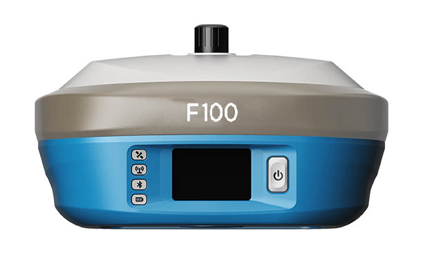
Geneq Inc.’s new F100 GNSS receiver, an upgrade to the F90, is designed to meet surveyors’ demands for high field performance, flexibility and cost-effectiveness.
The F100 tracks multiple constellations (GPS, GLONASS, Galileo, Beidou) and can maximize the acquisition and tracking process with all-in-view GNSS frequencies.
Another important feature from the F100 is the 1.45-inch color LCD display with a multi-touch capacitive screen. It has 32GB of internal memory. Its integrated second-generation web user interface control is compatible with all devices and all browsers.
Photo: Geneq
Providing maximum performance for accuracy and real-time measurements, F100 also supports real-time kinematic (RTK) correction services, including the RTX service that can get centimeter-level accuracy without a base station. The F100, with its advanced technology, ensures high performance even in difficult environments such as under heavy canopy.
The F100 has an excellent combination of GNSS, 4G, Bluetooth and Wi-Fi antenna. The innovative F100 has a built-in 5-watt radio that enables an effective baseline of 10 kilometers.
Its shorter charging time and a battery of 13600-mAh capacity enable long hours in the field. Even with its magnesium alloy casing, F100 weighs only 1.5 kg and measures 154 x 154 x 76 millimeters. Mobile field workers will find in this feature an ally to their surveying productivity.
With its integrated high-sensitive E-bubble and new tilt survey algorithm, the F100 becomes a calibration-free GNSS receiver. Immune to magnetic disturbance and free from limitation of tilt angles, the F100 can be used to measure unreachable points.
Everywhere we look, data is being collected, reviewed, analyzed and stored. It used to be that data was a static piece of information, like a piece of paper in a filing cabinet. Millions of pieces of data being created yet almost all of it never to be used again. The computer and electronic storage began a revolution of how we warehouse this information but that was only the beginning. Technology has turned data into a living, breathing beast few understand yet it controls most of our lives in various ways.
Mapping of the earth has not always been about establishing boundaries and parcels; many of the early maps and plats were created to depict the topography of our world. While there are some indications that Middle East maps depicted parcels, the first examples of topographic maps were created during the Roman Empire era of 300 A.D. It is common knowledge that the Romans utilized primitive yet cunning engineering for roads, buildings, and waterways but it was the initial topography that was mapped that allowed them to design those forward-thinking infrastructure components. Because of the lack of sophistication in the measuring methods and data collection, these topographic maps covered small areas and often crude because of the materials available. Considering what they were working with, it is still incredible what they were able to map, design and build.
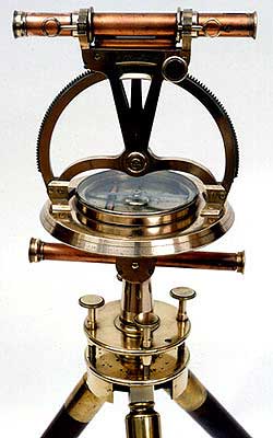
Measuring devices and methods of data collection expanded over the centuries like most occupations and professions. By the 16th and 17th century, mathematics has been introduced at a wider scale through many educational facilities. Another profession, geographers, also advanced with the evolution of measuring devices and mapping techniques. It was during this period that we began to see a crossover with surveyors with geographers to create topographic maps with greater accuracy and precision through triangulation.
In the 18th and 19th century, instruments became more sophisticated to assist in the determination of elevations and more accurate angle measurements. The concept of triangulation flourished during this period and significant mapping was made for most of the civilized world. The early 1800s saw the westward push of expansion in the United States and Thomas Jefferson, U.S. president and former surveyor, led the charge to map the existing states and divide the west into sectional land for sale to settlers.
Besides the establishment of the Public Land Survey System, surveyors also provided topographic information for map of all sizes for future development planning. The late 1800s brought a large amount of topographic mapping information to paper through efforts by the U.S. Geological Society to map the entire United States. This information has been called the first land database; although crude in overall nature compared to today’s standards, it contained an enormous amount of topographic information.
These surveys continued well into the early 20th century until a revolutionary invention coupled with a current technology merged: the use of a mounted camera taking aerial photographs from an airplane. Geographers and photogrammetrists were able to use surveying data to assist with scaling orthometric photographs to create aerial images of thousands of acres of land. These aerial photos became the base layer for determining topographic features and contouring, covering much more land than ever before. Additional innovations included advancements in stereo plotting and photogrammetric techniques to further create high sophisticated topographic maps for the era. This type of mapping was the gold standard for decades depicting existing condition and topographic features for most of the world until the early 1970s and the computerized data revolution.
Computers take over the world (literally)
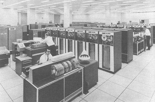
1960s mainframe computer (Photo: NASA)
While mainframe computers became more universally used in the 1960s, their use was contained to governmental agencies and large corporations. As the physical size of the computer reduced, the computing capacity increased, programming became easier to complete, and more applications were created to perform a variety of tasks. One of the biggest advancements for the era was electronic storage and analyzation of data through programming. Relational databases became a hot ticket for large datasets; geographic data was the perfect fit for this type of application. Modern mapping was on its way forward at warp speed.
Topographic mapping was not lost in this shuffle. The survey itself is based upon data points located on the face of the earth so each point is just another chunk of information within the database. Programming continued to advance and soon methods previous completed by manual methods over long periods of time were completed in a fraction of previous efforts without fail.
This effort was also joined with advancements in graphical technology to display this data on a computer video screen instead of lines of green text and numbers. Vector-based graphics, together with enormous point databases, helped create large topographical and geographical maps for many uses. During the same time the US put a man on the moon, mapping and platting of topographic information was also out of this world.
The turn of the century brings big changes
For the next decade, there were small advances in technology for topographic surveys and data points, but most were in presentation of data and increases in computing power. Pen plotters and smaller yet more powerful computers were becoming affordable to smaller companies, but it was still a large investment to get into the computerized data game for a surveyor. By the mid-1980s, electronic data collection with a total station was becoming the norm, but only meant collecting more points in a more efficient timeframe. The computing component did get faster but is still producing the same information of static data points.
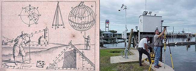
Ancient techniques and new technologies (Image: ngs.noaa.gov)
The mid-1980s also brought us a shiny new object: GPS technology. By the end of the 1990s, we were able to get out of our vehicle, start the receiver and collect geolocated points in minutes rather than hours. The big takeaway from this advancement is the geolocation component of the data point. Now everything can be related to one big dataset of topographical points. By creating a database with all our project data collected in the same georeferenced datums (horizontal & vertical), we can create digital models that replicate existing conditions.
We can also add another big advancement in data collection: remote sensing technology. From laser and lidar scanners, photogrammetry, SLAM technology and ground penetrating radar, the innovations to collect data at locations we can “see” through sensing are now a reality. Another significant improvement with this technology is the amount of data points remote sensing can collect, both in timing and spacing. We are now talking small scanning projects that consist of billions of points within the site point cloud. We are fortunate that our computing power and storage capabilities has increased exponentially along with the remote sensing. (Remember doing a “regen” on your CAD file and having time to get a cup of coffee?)
Lots of data — now what?
Data is powerful, especially when it is harnessed in a robust system that can analyze and model for future use. Yes, this condition also applies to the surveying world, even though you may not be thinking about it now. We can use this data to create a virtual world that mimics the one we live in; the difference is that we exist in ours yet model and manipulate the digital version in our computer system. The technology is now available, and we can make a replica of our current world; however, why would we want to do that? There are lots of reasons to use technology and data to make sophisticated topographic maps (because that is what they are) for recording the world around us.
One of the big differences now is that we have much more information about the data points we collect within our topographic maps. Sure, many surveyors will say that their data has not changed or evolved during their careers, but they would be wrong. Unless they are still manually writing it all down for hand plotting… (Hello! The 1960s called, and they want their field book back!) Every electronically collected point has attributes associated with the data.
These attributes, while they may be simple, contain important information about the datapoint it represents. Horizontal location? Check. Vertical elevation? Check. Assigned point number? Probably. Field code? Most likely. But it also has one other important component: time. We now know exactly when that point was collected. Why is that important?
Because, like a lot of instances, things change. Something collected today might not be there tomorrow. Time is just as important as the physical location and the type of point it represents.
Gather these points together, throw them in one big model and you have yourself a graphical database that can be analyzed, reviewed, and used for planning and design. It may be hard to visualize with just simple survey data using GNSS and/or a total station, but couple it with a scanner or photogrammetry, you have a powerful hunk of data for which to work.
Why is this workflow and modeling procedure important enough to dedicate an entire column about surveying and GNSS to? Because it used to be far in the future, but the need and availability to use it is now here in front of us. Surveying and GNSS are an important part of this effort to create three dimensional models. By using survey-grade data in conjunction with point clouds collected from remote sensing equipment, we can replicate the world around us in real time.
Yes, Virginia, there is a name for the modeling process…
Photo: iStock.com/alexsl
The name for the proposed modeling of this dataset is a digital twin. It represents a digital representation of a physical object or system. NASA famously used the concept for their space program to simulate situations and procedures of many different types of events. The concept has grown with the technology to graphically create almost anything through digitalization and computer modeling. Once the model is created, both actual and proposed data points can be included to represent the existing and future opportunities.
The idea of a digital twin is not new; technology, however, has pumped more life into its existence by leaps and bounds with computing power and data storage capability. I remember, early in my career, going into an architect’s office and seeing the scale model mockup of a new development or building. The streets in the model were perfect, there were no drainage issues, and it was a neat as a pin. Fast forward to the construction of the development and field changes were at every turn. A digital twin will allow for better planning, more thorough design and creating more cost-effective development. Many large cities have started compiling data and building their digital twin, including New York, Singapore, Boston, and Rotterdam. Engineering and planning for new and replacement facilities is very expensive yet analysts predict that having a digital twin to work will save a significant amount of money and time.
As a surveyor, what’s in it for me?
Software capability for the surveyor is already here. Companies, such as Hexagon, Trimble, Topcon and Esri to name a few, have been developing their software to accommodate this concept for many years. Still, lots of surveyors do not know about it. And we should. Many of us live in places where the infrastructure is well past its useful life period and should have been replaced long ago. By starting now with survey-grade data to be put into a real-time model, we can help our governmental agencies and their consultants to move towards a digital twin that will ultimately save money and possibly lives.
What this means for the surveyor is to further embrace technology and include remote sensing into your operation. If you have not started at least looking into UAVs and photogrammetry, you are already behind. Many aerial operations are making the next leap into mounting a LiDAR unit on their UAV to gain even more capability. Early adopters of laser scanners were probably second guessing their decision during the 2008 Depression but if they stayed with it, it will be a big payoff in the long run. The next leap will be into handheld scanning devices, including ones using SLAM (simultaneous localization and mapping) technology for locating interior and close-up improvements. These technologies will cost a significant amount of time and money to implement but municipalities, engineers and architects are going to be clamoring for the data any day now.
When it comes to surveying and mapping of existing facilities, the surveyor and technology makes a great team. Do not let point clouds, remote sensing, or terabytes of data scare you away from providing badly needed information to help assemble your local digital twin. In the long run, it will pay off for all who take on the challenge of building it.
On June 26, the U.S. National Oceanic and Atmospheric Administration (NOAA) released the summary of the results of Commercial Weather Data Pilot (CWDP) Round 2. View the summary here.
In Round 2, NOAA evaluated GNSS radio occultation data from two U.S. commercial space companies: GeoOptics and Spire. NOAA concludes that, based on the results of CWDP Round 2, the commercial sector is able to provide radio occultation data that can support NOAA’s operational products and services.
“As a result, NOAA is proceeding with plans to acquire commercial RO data for operational use,” the summary states.
According to GeoOptics, the report highlights the unique qualities of its commercial GNSS-RO data and its ability to improve weather and space weather forecasts around the world.
“As today’s report demonstrates, commercial satellite data will enable NOAA to make significant improvements in forecasting worldwide within the consistent budget limitations under which it operates,” said GeoOptics CEO Conrad Lautenbacher.
NOAA anticipates release of a request for proposals soon for operational purchase of commercial radio occultation data, continuing an acquisition process that began in April with NOAA’s release of a draft Statement of Work.
NOAA has requested $15 million in FY 2021 to support Commercial Data Purchase. The FY 2021 Budget also requests $8 million for CWDP to investigate new commercial technologies beyond radio occultation.
By moving into this next phase of engagement with U.S. industry, NOAA is leveraging commercial space sector capabilities to support its operational products and services and to continue to improve its weather forecasting capabilities. NOAA plans to implement additional rounds of the CWDP to evaluate commercial capabilities beyond radio occultation data for potential operational use.
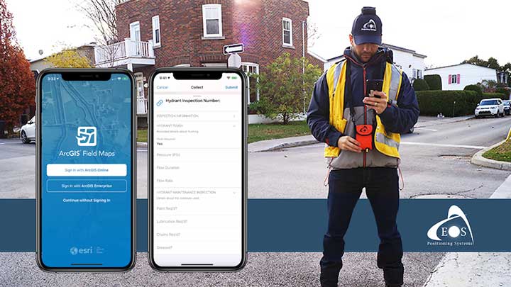
A new Esri mobile app, ArcGIS Field Maps, will be released in its first beta in July, with the final version expected to be released in September.
According to Esri, Field Maps will combine the following capabilities into a single app:
Simple map viewing and markup
High-accuracy field data collection and inspection
Battery-optimized location tracking
Work planning and task management
Turn-by-turn navigation
Field Maps also will include a new web app, integrated with ArcGIS, that can be used to configure and deploy maps optimized for your mobile workforce needs, create and assign tasks to mobile workers, and create and share views of worker locations.
Arrow support included
The inaugural beta includes support for Arrow GNSS receivers’ high-accuracy locations, elevations and metadata, according to Eos Positioning.
ArcGIS Field Maps will provide the combined functionality of five Esri mobile apps: ArcGIS Collector, ArcGIS Explorer, ArcGIS Tracker, ArcGIS Workforce and ArcGIS Navigator.
In the first beta version, users will be able to perform markups, work with read-only maps, and work with MMPKs, including high-accuracy GPS locations and metadata from Arrow GNSS receivers.
Photo: Eos Positioning
Customers who have been wanting to take advantage of high-accuracy GNSS data in apps such as Explorer and Tracker will now be able to with the beta release. Customers who would like to have field crews able to access read-only maps with high-accuracy, for instance (such as during utility locates), this is now a possibility. In addition, crews can take advantage of high-accuracy GPS tracks while tracking.
ArcGIS Field Maps will also support the two formerly Collector-exclusive Eos solutions Eos Locate and Eos Laser Mapping.
Eos Locate. This high-accuracy underground mapping solution will be available in ArcGIS Field Maps right away in the first beta release. A single fieldworker will be able to perform real-time, high-accuracy mapping of underground assets using the same workflow he or she had previously used with Collector and Arrow GNSS.
Eos Laser Mapping. Similarly, laser offsets with Arrow GNSS receivers and LTI laser rangefinders will be available in the first beta of ArcGIS Field Maps. Learn more about laser offsets, including the three workflows for using them, here:
“We are incredibly excited for the new opportunities ArcGIS Field Maps brings to expand our partnership with Esri,” Eos CTO Jean-Yves Lauture said. “Now our joint customers will be able to use the Arrow GNSS receivers with Field Maps to access high-accuracy location when simply viewing and marking up maps and when logging location tracks.”
Eos Positioning told its customers, “We encourage all Eos customers currently using Collector, Tracker and/or Explorer to join the beta. Meanwhile, Collector, Tracker and Explorer are planned to continue working as usual, according to the roadmap Esri has outlined.”