The F-110 frigate being developed for the Spanish Navy. (Artist’s concept: Spanish Ministry of Defense)
The technology multinational GMV has signed a contract with Spanish corporation Navantia to develop and supply its SENDA navigation system for the future F-110 frigates.
The F-110 frigates represent a technological leap forward in platform systems and its combat system, incorporating Industry 4.0 technologies to improve lifecycle-long system management.
The various F-110 systems call for a continuous, precise, and trustworthy positioning, speed and attitude source. With this purpose in mind, SENDA incorporates multi-constellation (GPS and Galileo) satellite navigation technology compatible with both civil and military signals, plus differential GNSS corrections. It combines its GNSS navigation data with data received from external sensors, such as inertial navigation systems (INS) and pitometer logs. It includes state-of-the-art algorithms to provide robust navigation in contested GNSS scenarios.
SENDA also includes a timing server that generates highly precise and stable timing signals, allowing the ship’s systems to synchronize with GPS time. SENDA guarantees timing-reference stability and negligible drift, even during prolonged periods of GPS downtime.
SENDA is a redundant system with two complete functional subsystems working in active-active configuration, together with redundant GNSS signal distribution. Both systems, monitored in real time, exchange information to provide the overall system with the best possible solution.
GMV has experience in aeronautics, land and naval sectors with platforms such as the Atlante tactical long-endurance UAV, the 8×8 Dragon ground vehicle and now the F-110 frigates.
GMV worked with the Spanish Ministry of Defense MoD to develop a system prototype during the F-110 definition phase. The future F-110 frigates will replace the current Santa María class frigates starting in 2026.
The U.S. military selected Orolia Defense and Security to supply multiple BroadSim advanced GPS simulator systems, a contract valued at $1.7 million (USD), in an effort to upgrade testing facilities and field test assets.
The BroadSim Advanced GNSS Simulator (Photo: Orolia)
These new simulator systems will enable better testing of widely deployed military GPS receivers, which are integrated into air and ground-based positioning, navigation and timing (PNT) systems.
BroadSim will be leveraged with Orolia’s Panacea test suite, which the U.S. military uses to conduct automated testing and analysis for PNT system performance and vulnerabilities.
BroadSim will bring versatility to the testing process by supporting diverse test methods and environments such as a laboratory setting, or an over-the-air (OTA) field test event.
BroadSim was selected based on its flexibility to support the ever-changing military tasks at hand, according to Orolia. It can be easily configured to support laboratory testing one day, and field testing the next with its four independent RF outputs, removable drives, and software-defined architecture.
“Equipping our actively deployed warfighters with state-of-the-art technology is of utmost importance and can mean the difference between mission success and failure. To help achieve that goal, Orolia’s GPS testing and simulation solutions ensure that these systems are battlefield ready,” said Tyler Hohman, Orolia Defense and Security’s director of products.
Orolia will host a webinar on this topic on Thursday, July 16, at 2 p.m. EDT, titled “PNT Vulnerability Testing for Critical Infrastructure:Lessons Learned from Defense.”
The federal government considers PNT to be a critical aspect of mission success, as outlined in the C4ISRNET white paper “Protecting the U.S. Military PNT Advantage from GPS Jamming and Spoofing” and defined in the PNT Executive Order. For the 2021 federal fiscal year, the U.S. Army alone budgeted more than $275 million towards Assured PNT Research, Development, Test & Evaluation (RDT&E), as published in the 2021 Defense Budget.
The huge current investment in deploying 5G mobile networks is promoted by setting high expectations for significantly increased throughput and reduced latency.
This can only be realized by deploying the network radios close to the users, especially for the millimeter-wave frequencies with their short propagation distance.
This also means a high density of radios, often imbedded within macro coverage.
To coordinate seamless functioning, network synchronization accuracy must be much higher than with legacy deployments, according to Optical Zonu. The greatly enhanced data throughput with advanced features such as aggregation, massive multiple-input/multiple-output (MIMO) and beam steering require highly accurate network timing and phase coordination.
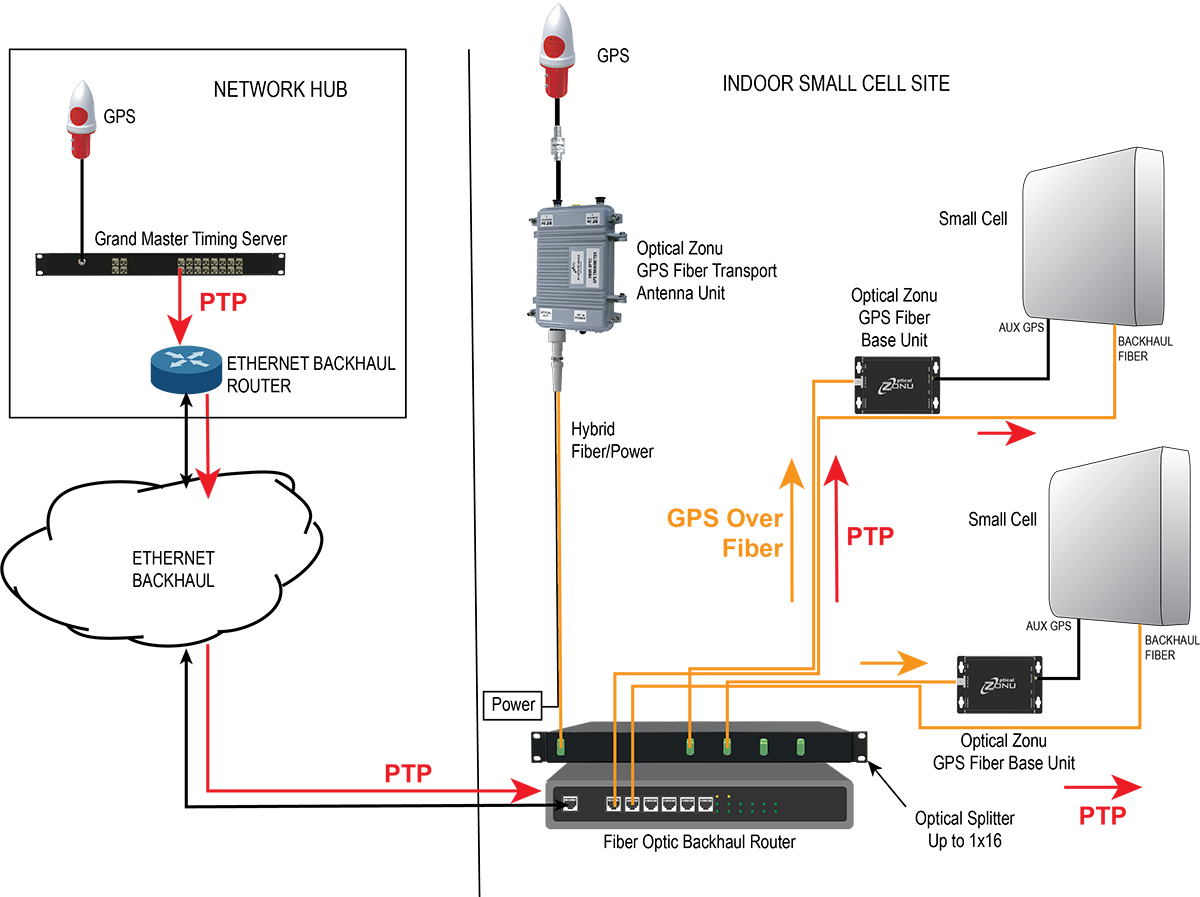
Small cells close to a network’s edge are usually far from the hub where the grandmaster timing server generates the PTP timing signal and sends it to the network edge over the Ethernet backhaul. The long runs require multiple hops through routers and switches. Each of these adds dynamically changing packet delays depending on network loading. Also, there are inevitable asymmetries between the upstream and downstream packet delays. These timing errors can result in a drastically reduced network performance.
One way to correct these timing errors is to connect an edge grandmaster server at the small cell location connected to the local backhaul router. Connecting the GPS directly to each of the small cells is the other way.
The GPS approach is simple in concept, but has been problematic since, with small cells distributed in the facility, many or all the units can be far from a window where a GPS antenna could be mounted.
Optical Zonu, a U.S. carrier-approved supplier of RF-over-fiber transport solutions, has solved this problem with its GPS at the Edge kit. The GPS-over-fiber solution distributes GPS to each small-cell location alongside the backhaul.
A compact GPS fiber antenna unit connects to a GPS antenna on the roof. A single cable connection to this unit provides power to the unit and brings the fiber-optic connection to an optical splitter, which is collocated with the local router for the small-cell backhaul.
The fibers from this splitter are routed along with the backhaul cable to each small-cell location, where they each connect to a small fiber base unit that recovers the GPS signal and connects it to the auxiliary GPS port on each small cell.
Optical Zonu offers two variants.
Small cells with fiber-optic backhaul. Higher power cells typically use a fiber-optic backhaul and require local AC power. In this case, one of the fibers in the cable to each small cell is used for the GPS connection, and each base unit connects to the local AC power with an adapter. In this case, the only additional cable needed is the single run to the rooftop.
Diagram: Optical Zonu
Small cells with a CATx backhaul. This setup is typical for lower power small cells. In this architecture, a single fiber is pulled along with the CAT6 backhaul cable. A single hybrid fiber/CAT6 cable can also be used. The fiber is connected to a small fiber base unit at each small cell to recover the GPS signal, which is connected to the small cell auxiliary GPS port. The CAT6 is also connected to the fiber base unit. The backhaul is passed through from the small cell, and the PoE++ is tapped to power the base unit. Once again, the only additional cable pull is the single run to the rooftop antenna — local power isn’t needed at every small cell location.
Diagram: Optical Zonu
The Optical Zonu GPS at the Edge kit provides an easy-to-install and cost-effective solution that guarantees the highest timing and phase accuracy for a network that is vendor agnostic and, as with the edge grandmaster approach, still has the central PTP as a backup.
“Recognizing the importance of driving engagement on future research, development and deployment of automated vehicles, we are confirming that all of the important content already planned for this year’s program will take place within a fully interactive virtual event platform,” organizers said.
The event will feature live sessions and networking, as well as a customizable schedule. In addition, keynote and plenary sessions will explore how society, technology and policy are preparing for and shaping the future of mobility.
Australia-based Position Partners has launched MiRTK, an open architecture corrections service for GNSS equipment.
Internet-enabled, MiRTK offers an alternative to UHF radio correction services for high-accuracy GNSS. Unlike UHF radios, MiRTK is not limited by range from the GNSS base station and does not require line of sight with the survey rover or machine.
MiRTK uses a small modem that slides onto the accessory slot of the tripod and connects to the base station via a single cable.
A subscription service is available in locations with the Telstra network, mainly continental Australia.
MiRTK is designed for accurate GNSS positioning in the construction, mining and geospatial industries. It is compatible with all brands and models of GNSS from manufacturers including Topcon, Trimble, Leica Geosystems, Sokkia, Hemisphere and more.
“Until now, users that rely on high-precision GNSS for applications such as surveying and machine control had no option but to use UHF radios or a network RTK solution,” said Cameron Waters, geospatial business manager at Position Partners.
“Anyone that’s had to rely on UHF radio frequencies will have experienced problems, including interference, range limitations, costly licensing and severe penalties for breaching licensing laws. MiRTK offers an alternative that is refreshingly simple: no repeaters, no line of sight issues and no complex licensing,” he added.
The Galaxy lithium mine in Ravensthorpe, Western Australia. (Photo: jasonbennee/iStock / Getty Images Plus/Getty Images)
Another benefit, according to Waters, is the ability to utilise a single correction protocol across all GNSS equipment on site. This dramatically reduces complexity and potential connectivity issues. “MiRTK uses NTRIP and a user selectable format such as RTCM3 or CMR, that can be used universally regardless of the brand or model of equipment,” he said. “Users enjoy full speed, full constellation connectivity without the complex radio settings, baud rates, bandwidth or scrambling problems that you get when trying to utilize different GNSS systems with UHF radios.”
To set up the unit, users simply connect the modem to the base station, power the modem on and MiRTK will work for up to 20 hours continuously without charge. Each unit can connect with up to 10 devices such as survey rovers or machine systems as standard, with unlimited potential to scale up connections as required.
“The future of UHF is limited with lower bandwidth, higher density areas, increased governance, rising costs and little flexibility,” Waters said. “MiRTK gives customers a new approach to receive reliable correction data in a simple and hassle-free way, whilst utilizing their existing GNSS hardware.”
Two F-16 Fighting Falcons fly over Edwards AFB during a 2009 air show. (Photo: U.S. Air Force/Chad Bellay)
The U.S. Air Force in September will begin testing on F-16’s an alternative position, navigation and timing (PNT) solution that uses the Earth’s magnetic anomalies.
The navigation technique, dubbed MAGNAV, is being researched at the Air Force Institute of Technology (AFIT), reports Forbes.
Air Force Major Aaron J. Canciani, an Assistant Professor of Electrical Engineering at AFIT, designed algorithms for MAGNAV flight testing on F-16s. Testing has already taken place using private survey aircraft.
MAGNAV sensors and software will be flown on Air Force Test Pilot School (AFTPS) F-16s over a special test range adjacent to Edwards Air Force Base in Nevada.
Magnetic anomaly navigation uses scalar magnetometer sensors that measure differences in the magnitude of magnetic fields when traveling past them. These variations can be compared with known features in magnetic field maps and be interpreted to determine position.
The four pillars of MAGNAV are magnetic maps, sensors, algorithms and calibration. The magnetic maps already exist within industry, the military and government agencies including NOAA, NASA, NGA and more.
NOAA’s EMAG2 (v3) World Digital Magnetic Anomaly Map. (Image: NOAA National Geophysical Data Center)
U.S. Air Force photo by Airman 1st Class Josie Kemp
The Swedish Defence Materiel Administration (FMV) signed a contract with navigation company iXblue for up to 172 FOG-based Quadrans gyrocompasses. The Quadrans navigation systems will be delivered over four years and will equip the Swedish Navy’s fleet of high speed crafts, mainly combat boats CB90.
“The FMV was seeking new maintenance-free and high-performance gyrocompasses for the retrofit of their fleet of high speed crafts,” said David Cunningham, commercial director at iXblue. “The CB90 vessels are indeed very fast boats and need the most reliable and accurate heading and attitude data to navigate safely. With our Marins Series Inertial Navigation Systems being already in service on the Gotland-class submarines and Koster Class MCMV’s, and our Quadrans gyrocompasses equipping other surface boats in the Swedish Navy fleet, the FMV was familiar with the high-performance delivered by our systems and knew the Quadrans met the specific requirements needed for the CB90.”
The Quadrans gyrocompasses are build around iXblue’s Fiber-Optic Gyroscope technology. According to the company, the gyrocompasses provide highly accurate heading and attitude data and are perfectly suited for high performance at high speeds and in challenging environments such as GNSS-denied settings.
In addition, the Quadrans Gyrocompasses are compact, lightweight and with low power consumption. They’re easy to install on small-sized crafts, while their open architecture guarantees seamless interfacing with all major GNSS systems and third-party navigation software, iXblue added.
New GPS-synchronized Ninja Precision Timing Module provides a myriad of time and frequency outputs with high performance in a small, low-power platform.
Photo: EndRun
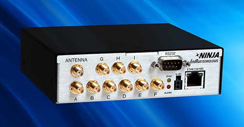
EndRun Technologies, a provider of precision time and frequency solutions, has released the high-performance Ninja Precision Timing Module (PTM). The third-generation Ninja — optimized for size, weight and power (SWaP) — can be easily integrated into 1U host systems or deployed as a cost-effective standalone solution.
The resilient GPS-synchronized Ninja is based on the core of EndRun’s Meridian II Precision TimeBase instrument. Up to nine optional, user configurable, time and frequency outputs are available with accuracy, stability and ultra-low phase noise. Ninja’s network interface includes a robust Network Time Protocol (NTP) server as well as secure management.
Three OCXO reference oscillators are available to meet price-performance requirements. Advanced users can optimize Ninja with EndRun’s innovative Real-Time Ionospheric Corrections (RTIC) to directly measure and compensate for ionospheric delay of received GPS signals in real-time.
“The Ninja Precision Timing Module is another breakthrough solution from EndRun that provides an abundance of outputs in a small form factor without compromising performance,” said Michael Korreng, senior R&D engineer, EndRun Technologies. “The high-level of integration and output versatility readily integrates into many mission critical applications including SATCOM, tactical communications, signal intelligence, security camera synchronization, digital broadcast, network synchronization, range timing, and many more.”
Key Ninja performance specifications with Ultra-Stable OCXO, Real-Time Ionospheric Corrections, and calibration are:
Time accuracy of <10 nanoseconds RMS to UTC(USNO)
Frequency accuracy better than 4×10-14 (100k second average)
GNSS Underground Coverage for Tunnels, Stations, Car Parks, Bus Stations and Airports in the U.K.
Syntony GNSS and Chronos Technology have formed a partnership to deliver underground GNSS positioning, navigation and timing (PNT) solutions for critical infrastructure applications in the United Kingdom.
Syntony GNSS is a leader and expert in the design and manufacture of GNSS systems, and Chronos Technology is a resilient GNSS system integrator.
GNSS coverage has become fundamental to many services from emergency services to asset tracking for example. Yet when entering an underground area such as a metro/subway, tunnel, car park, airport, or bus station for example, the GNSS signal is lost.
Syntony’s SubWAVE solution expands the GNSS coverage to underground areas, enabling the localization of any equipment with a standard GNSS chipset. Examples include standard smartphones and the TETRA Emergency Services Network handset used for security and services. Security and services applications include locating emergency calls, keeping track of staff, locating faults in tunnels, managing assets, locating trains and providing guidance.
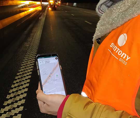
A Syntony team member in a Swedish road tunnel during SubWAVE testing shows the positioning in an underground environment on a smartphone. (Photo: Syntony GNSS)
By emitting a perfect emulation of the “real” GNSS signal, SubWAVE offers underground operators, their staff, emergency services and the general public the benefit of full GNSS coverage in all underground areas for both operational and safety reasons.
One fundamental aspect is the user only needs a standard GNSS receiver (a smartphone or TETRA radio) — no new handsets, receivers or apps are required. The system operates by broadcasting synthetic location specific GNSS signals through existing or new leaky feeder cables in the tunnels.
Accuracy levels vary with leaky feeder and system complexity options; however, 2-meter accuracy is possible with a standard smartphone. The system is widely installed in the Stockholm metro and is in active trials throughout Europe and America.
“We are pleased to form a partnership with GNSS specialists Chronos,” said Joel Korsakissok, president of Syntony GNSS. “Their knowledge and experience, together with their dedicated installation, commissioning and support teams complement our sophisticated solutions.”
“Since its first general availability, one of the well-known shortcomings of the GPS system was lack of indoor or underground coverage,” said Charles Curry, managing director with Chronos. “Many have tried to solve this with various technologies over the years. Syntony’s innovative technology offers underground GNSS coverage for PNT applications. We are very excited by the possibilities and pleased to be partnering with them to offer their solution for critical infrastructure applications in the UK.”
In addition, Chronos will also supply Syntony’s sophisticated GNSS simulators used in the aerospace and defence industries for product testing.
The non-profit 211 LA County and Slingshot Aerospace have unveiled an online mapping tool that allows users to quickly identify and locate more than 2,000 food resources within the county during and after the COVID-19 pandemic.
211 LA County is a non-profit organization providing the official information and referral source for health and human services in LA County. Slingshot Aerospace is a situational intelligence platform company,
The customized tool, called 211 LA FoodFinder, is powered by Slingshot Earth and is the biggest and only food map that allows LA residents to search for resources by location and view services specific to seniors, children and others, enabling individuals to find aid near them faster. Resources within the FoodFinder are free, with the exception of those with suggested donations or delivery service fees.
LA County residents will be able to identify different types of available food resources, such as child nutrition, meal services, groceries/food pantries, senior food needs and government food benefits programs.
The platform also provides location details, hours of operation and contact information for each of the services. 211 LA County is currently experiencing a tenfold increase in website traffic related to food resources compared to pre-COVID timeframes.
The organization anticipates the robust application to service nearly 30,000 LA County constituents over the next quarter, many of which may not have prior experience with food assistance.
“Food resources are the biggest need people are contacting us about since the COVID-19 pandemic hit LA County,” said Maribel Marin, executive director, 211 LA County. “With so many people out of work, the need for food is going to get progressively more intense, but people shouldn’t worry because there are lots of resources and ways to access them. Our custom Slingshot Earth food locator provides our community with a one-stop-shop for food resource information, helping to provide peace of mind to those who need food assistance during this unprecedented time.”
211 LA County’s customized Slingshot Earth mapping tool aggregates food resources and service data from multiple public and private sources so that individuals have the right information, at the right time, all in one place. The data is verified and updated regularly to ensure that Los Angeles County residents have the most up to date information as guidelines and offerings continue to evolve.
“This work to help 211 LA County provide critical food service information in our community is so meaningful to us because we are driven by a vision to create a safer, more sustainable world,” said Mel Stricklan, Co-Founder and Chief Strategy Officer, Slingshot Aerospace. “Our business was founded on the idea that information is power, especially in complex situations. The COVID-19 pandemic is uncharted territory for all of us, and we are happy to do our small part in navigating these tough times by providing essential information to those who need it most.”
The United States Space Force’s GPS III program reached another milestone with the successful core mate of GPS III Space Vehicle 08 at Lockheed Martin’s GPS III Processing Facility in Waterton, Colorado, April 15.
With core mate complete, the space vehicle was named in honor of NASA trailblazer and “hidden figure” Katherine Johnson.
The two-day core mate consisted of using a 10-ton crane to lift and complete a 90-degree rotation of the satellite’s system module, and then slowly lowering the system module onto the satellite’s vertical propulsion core. The two mated major subsystems come together to form an assembled GPS III space vehicle.
Despite the COVID-19 pandemic, the Space and Missile Systems Center (SMC) and its mission partner Lockheed Martin ensured that SV08 core mate took place, in accordance with all Centers for Disease Control and local guidelines to minimize exposure or transmission of COVID-19. The GPS III Processing Facility’s cleanroom high bay was restricted to only key personnel directly supporting the operation.
“Core mate is the most critical of the GPS space vehicle single-line-flow operations,” said Lt. Col. Margaret Sullivan, program manager and materiel lead for the GPS III program. “Despite the restrictions presented by the COVID-19 pandemic, our team adapted and worked tirelessly to achieve this essential milestone.”
Katherine Johnson. (Photo: NASA)
Katherine Johnson. When the core mate operation is successfully completed, a GPS III satellite is said to be “born.” In keeping with the team’s tradition of naming GPS III satellites after famous explorers and pioneers, SV08 was named “Katherine Johnson” in honor of the trailblazing NASA mathematician and “human computer” who designed and computed orbital trajectories for NASA’s Mercury, Apollo and space shuttle missions.
One of four African-American women at the center of the nonfiction book by Margot Lee Shetterly and the movie Hidden Figures, Johnson was awarded the Presidential Medal of Freedom in 2015 for her groundbreaking contributions to the U.S. space program.
Other GPS III satellites have been named in honor of explorers including GPS III SV01 “Vespucci” after Amerigo Vespucci; GPS III SV02 “Magellan” after Ferdinand Magellan; and GPS III SV03 “Columbus” after Christopher Columbus.
Next up, performance tests. The next step for the newly christened “Katherine Johnson” is the post-mate Systems Performance Test (SPT) scheduled to begin in August. SPT electrically tests the performance of the satellite during the early phase of build and provides a baseline test data set to be compared to post-environmental test data.
GPS III SV08 is currently scheduled to launch in 2022.
The Mobile Service Tower rolls back from the ULA Delta IV rocket carrying the GPS III SV02 satellite in preparation for launch. (Photo: ULA)
GPS III is the most powerful GPS satellite ever developed. It is three times more accurate and provides up to eight times improved anti-jamming capability over previous GPS satellites on orbit. GPS III brings new capabilities to users as a fourth civilian signal (L1C), designed to enable interoperability between GPS and international satellite navigation systems, such as Europe’s Galileo system.
GPS III satellites will also bring the full capability of the Military Code (M-code) signal, increasing anti-jam resiliency in support of the warfighter. These continued improvements and advancements to the GPS system makes it the premier space-based provider of positioning, navigation, and timing services for more than four billion worldwide.
GPS III SV03 is scheduled to launch on June 30.. (Photo: Lockheed Martin)
GPS III SV03 to Launch June 30. Launched in December 2018 and August 2019, GPS III SV01 and SV02 became part of today’s operational constellation of 31 satellites, on January 13 and April 1, 2020 respectively. GPS III SV03 is scheduled to launch on June 30.
The SMC, located at the Los Angeles Air Force Base, California, is the center of excellence for acquiring and developing military space systems. Its portfolio includes the GPS, military satellite communications, defense meteorological satellites, space launch and range systems, satellite control networks, space based infrared systems, and space situational awareness capabilities.
Orolia and Seven Solutions have partnered to deliver resilient, accurate, and stable time and frequency for global military, commercial and critical infrastructure applications.
According to the companies, the partnership will address the ultra-precise, resilient timing and frequency requirements of industries such as defense, aerospace, data centers, telecom, financial services, smart grids and other critical infrastructure.
Through the partnership, Orolia will offer a modular approach to resilient PNT, which includes a combination of GNSS signals protected with interference detection and mitigation technology, together with low Earth orbit secure alternative signals. The Orolia-Seven Solutions partnership also will offer terrestrial sub-nanosecond time distribution from distant and potentially redundant locations.
“This partnership is a key example of Orolia’s commitment to combining best-in-class technologies into more robust resilient PNT solutions for our customers,” said Orolia CEO Jean-Yves Courtois. “Those who require the most accurate, extremely precise time and frequency technology will now also benefit from an unprecedented level of resilience to protect critical PNT data sources, for more confidence and peace of mind.”
This new partnership between Seven Solutions and Orolia will facilitate global operations and naturally integrate with reliable time sources. Seven Solutions will focus on bringing the best-in-class time and frequency distribution, the companies said.