Category: Applications

  • The latest on defense/PNT product developments

    The latest on defense/PNT product developments

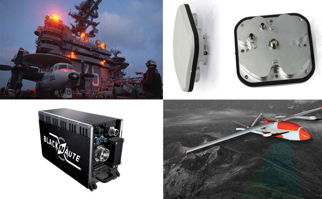
    1. Anti-jamming antenna

    For defense, marine and critical infrastructure 

    Photo: Calian, GNSS
    Photo: Calian, GNSS

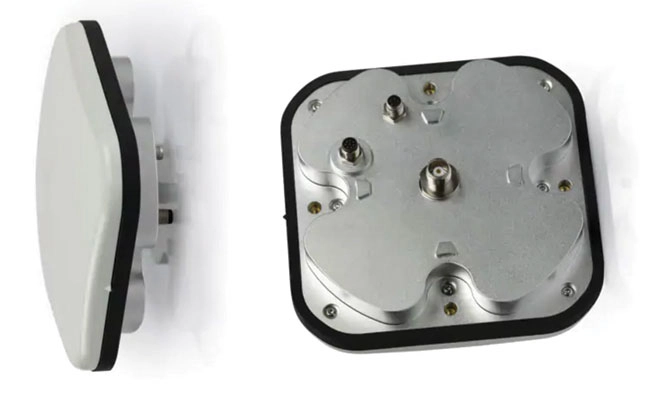
    The CR8894SXF+ is an advanced controlled reception pattern antenna (CRPA) for anti-jamming. It is engineered to provide efficient interference protection and real-time situational awareness across critical infrastructure, marine and defense environments where GNSS continuity is mission critical. It is specifically designed to provide a low-power and lightweight solution in a compact size. It features advanced in-band null forming to protect GPS L1/L2 and Galileo E1/E5b signals, helping ensure resilient positioning, navigation and timing in environments with contested, congested or degraded radio frequency conditions. The antenna incorporates Calian’s eXtended Filtering interference mitigation technology to maintain performance and reliability when RF threats are present. The CRPA supports in-band null-forming of 20 dB to 40 dB and out-of-band rejection up to 80 dB across 700 MHz to 2,500 MHz. It includes two independent low-noise amplifier channels, allowing continued operation if one signal band is compromised. The antenna forms nulls in both upper (L1/E1) and lower (L2/E5b) GNSS bands to actively suppress jamming sources. A serial output interface provides real-time feedback, enabling users to monitor RF conditions and system status. 

    Calian GNSS, calian.com
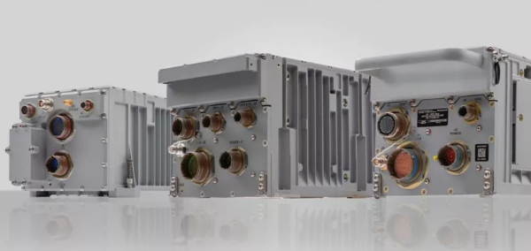
    2. PNT System

    Integrates GNSS receiver, INS, atomic clock 

    Photo:
    Photo: Safran Electronics & Defense

    The BlackNaute autonomous positioning, navigation and timing (PNT) system integrates Safran’s HRG dual-core inertial navigation technology, the Skylight multi-mode GNSS receiver board, and an atomic clock to offer navigation resilience in challenging electronic warfare environments. BlackNaute’s built-in atomic clock is designed to maintain precise timing, which is essential for secure communications and collaborative combat operations. The system features advanced anti-jamming and anti-spoofing algorithms, which have been validated in more than 16,000 operational cases. These capabilities allow BlackNaute to detect compromised signals and automatically switch to autonomous and trusted navigation and timing sources to ensure continuity of operations. Its modular design allows it to be adapted across a variety of platforms. Airbus Helicopters has selected the NH90 to be equipped with this new Embedded GNSS and Time INS (EGTI). 

    Safran Electronics & Defense, safran.com

    3. Interference detection

    Suite enhanced for greater accuracy, coverage and insight 

    Photo:
    Photo: US Navy

    HawkEye 360’s GNSS-I Detection suite includes powerful enhancements to its GNSS interference detection capabilities. The upgrades — designed with defense, intelligence and national security operations in mind — offer unprecedented accuracy, coverage and insight into global GPS jamming and spoofing threats. The update includes a new wider frequency algorithm that better distinguishes individual emitters, incorporates GPS spoofing detection, and is terrain adjusted for better geolocation accuracy, delivering greater situational awareness and more precise geolocation of interference sources worldwide. The enhanced product suite supports strategic decision-making by providing timely, precise insight into potential signal disruptions, enabling stakeholders to better assess risk, respond confidently, and maintain operational continuity in dynamic environments.

    HawkEye 360, he360.com

    4. VTOL UAS

    For complex intelligence, surveillance and reconnaissance missions 

    Photo: ESEN-UAS
    Photo: ESEN-UAS

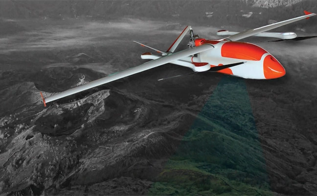
    The GöKHUN unmanned aerial system (UAS) is a tactical vertical take-off and landing (VTOL) drone system developed for versatile missions on land or at sea. GöKHUN combines the compact mobility of a NATO Class I UAV with the performance data of a Class II tactical system. It uses the SP 210 FI GS 2-stroke engine from Sky Power International. With a take-off weight of up to 110 kg and a maximum fuel and payload capacity of 26 kg, the GöKHUN can remain in the air for up to 16 hours with a minimum payload. Even with a demanding sensor load of 12 kg, it can achieve a flight duration of around nine hours, making it suitable for long-endurance reconnaissance and surveillance missions. The GöKHUN’s cruising speed is between 96 and 158 km/h. The maximum range with direct line-of-sight is over 150 km, with the system reaching a service ceiling of approximately 5,500 m.

    ESEN, esensi.com.tr 

  • Launchpad: The latest defense, OEM and surveying & mapping products

    Launchpad: The latest defense, OEM and surveying & mapping products

    Click below to read a roundup of recent products in the GNSS and inertial positioning industry from the October 2025 issue of GPS World magazine.

    Defense

    • Anti-jamming antenna: For defense, marine and critical infrastructure 
    • PNT system: Integrates GNSS receiver, INS and atomic clock 
    • Interference detection: Suite enhanced for greater accuracy, coverage and insight 
    • VTOL UAS: For complex intelligence, surveillance and reconnaissance missions 

    OEM

    • Precision card: High-accuracy positioning with the mosaic-X5 
    • Spoofing mitigation: Can protect GPS, BeiDou and Galileo signals

    Machine Control

    • Autonomous steering package: Allows upgrades of older machinery for small farms 

    Surveying and Mapping

    • Data collection software: Intuitive workflows require minimal training
    • Mobile mapping system: Lidar collects 2 million points per second
  • FAA warns pilots of risks in flying over Venezuela

    FAA warns pilots of risks in flying over Venezuela

    The U.S. Federal Aviation Administration (FAA) has warned all pilots to “exercise caution” when flying in the airspace over Venezuela “due to the worsening security situation and heightened military activity,” reports ABC News. Possible risks include GNSS jamming and spoofing.

    The FAA message said the unspecified threats “could pose a potential risk to aircraft at all altitudes” as well planes taking off and landing in the country and even aircraft on the ground.

    The warning comes as the Trump administration has ramped up pressure on Venezuelan President Nicolás Maduro. The Trump administration also has carried out a series of strikes on small boats in the Caribbean Sea and eastern Pacific Ocean that it accuses of ferrying drugs to the U.S., killing more than 80 people since the campaign began in early September.

    The U.S. military has conducted bomber flights up to the coast of Venezuela, sometimes as part of a training exercise to simulate an attack, and sent the aircraft carrier USS Gerald R. Ford into the region.

    The Ford aircraft carrier and several destroyers were just the latest addition to the largest U.S. force assembled in the Caribbean Sea near Venezuela in generations. The Trump administration does not see Maduro, who faces charges of narcoterrorism in the U.S., as the legitimate leader of the South American country.

  • Tern IDPS selected to accelerate autonomous satellite-free positioning

    Tern IDPS selected to accelerate autonomous satellite-free positioning

    Tern has been named a winner of the U.S. Army’s xTechOverwatch for Unmanned Systems competition. TERN was selected from morethan 600 companies after hands-on Soldier testing at the Bush Combat Development Complex in Bryan, Texas, Oct. 27-29.

    Tern developed an AI-powered Independently Derived Positioning System (IDPS) for position and navigation.

    xTechOverwatch is the Army’s premiere event for accelerating autonomous systems, giving
    soldiers the opportunity to use emerging technologies in real-world training environments and
    provide critical feedback that drives iterative improvement.

    The system has been tested across multiple tactical platforms in both on- and off-road environments, including active conflict zones.

    Tern will now integrate IDPS directly with Army Transformation in Contact formations, where active-duty units will continue to validate the system in operational scenarios in 2026.

    How IDPS works

    IDPS has been proven to deliver uninterrupted, high-accuracy navigation in environments where GPS fails — tunnels, dense urban canyons, remote terrain, and GPS-denied zones. Tested by the U.S. Department of Transportation, it has sustained ±4-meter accuracy over extended distances without any satellite input, completing more than180 continuous miles GPS-free and performing flawlessly under live GPS spoofing in a conflict zone.

    Tern’s IDPS gives the Army the ability to navigate their vehicles without the use of any
    satellites, signals or infrastructure, using only map data and the sensors already on board.
    Designed by former special operators who spent years navigating contested terrain without
    satellite support, and developed with AI experts behind some of the fastest recognition systems
    in the world, IDPS maintains precise, real-time location even when GNSS is jammed or
    spoofed. The system has been tested across multiple tactical platforms in both on- and off-road environments, including active conflict zones.

    Base maps. IDPS has a clear understanding of the roads ahead using preloaded map data — either publicly available or proprietary. This built-in knowledge means it can follow a logical path, even in places where satellites can’t reach, keeping navigation steady from the first turn to the final destination.

    IDPS can stand alone or be configured to power a location manager and integrate with widely used navigation applications such as Google Maps, Waze, OSM, ESRI, ArcGIS and Apple Maps.

    Sensor data. TERN’s IDPS leverages data from sensors already built into modern vehicles, such as wheel speed, steering angle, and  3D motion data , making these existing sensors smarter. Because this information comes directly from the vehicle, it works anywhere the vehicle can operate, making it a reliable foundation for location tracking in any environment, eliminating the need for additional expensive hardware, such as LEO satellites or terrestrial beacons. With a light computing and processing load, IDPS is can be a hardware or software based solution.

    Artificial intelligence. IDPS uses a proprietary AI engine to fuse map data and sensor inputs into a real-time position. TERN’s  advanced adaptive weighting algorithms measure and interpret the data from vehicle sensors and recalibrates those inputs in real-time, applied against the base maps to increase accuracy.  Constantly self-healing, IDPS predicts, confirms, and refines the vehicle’s location, learning from each movement to maintain pinpoint accuracy without satellites.

  • Honeywell authorized for US M-code military navigation solution

    Honeywell authorized for US M-code military navigation solution

    Honeywell has received U.S. government authorization for the remaining variants of its M-code GPS Inertial Navigation System (EGI), which will help enable more secure and precise navigation for military aircraft worldwide.

    Honeywell was awarded the MSO-c145b authorization by the Precise Position Equipment Certification Office (PECO) for its smaller form factor embedded GPS EGI, known as the FALCN. Honeywell received the same authorization for its large form factor system last year.

    With this new qualification, all of Honeywell’s EGI offerings are certified and approved by the U.S. government, and it can now offer solutions on platforms such as the collaborative combat aircraft and fixed-wing advanced fighters.

    Reliable on-board navigation systems, such as the GPS EGI, are critical to ensuring mission success and operational safety for military and civilian operators. These systems are not just tools for determining location, but essential for strategic planning, coordination and effective execution of tasks, especially in complex and high-risk environments. Accurate navigation enables personnel to operate with precision, even in GPS-denied or contested areas, contributing directly to the safety and effectiveness of military operations.

    “Our innovative EGI offerings will enable aircraft platforms to meet the latest M-code mandates and to navigate both in contested environments and off of GPS constellations with military waveforms, all while protecting warfighters with the most advanced technology in the market,” said Matt Picchetti, vice president and general manager, Honeywell Aerospace.

    The advent of GPS M-code receivers is the greatest advance in military positioning, navigation and timing since GPS was originally fielded in the early 1980s. With Honeywell’s FALCN-M now upgraded with M-code capability, aviators will be protected from GPS jamming and spoofing threats, further enabling them to confidently conduct military operations in highly contested environments.

    Honeywell is a leader in EGI technologies for military applications and, since the mid-1990s, has provided more than 60,000 EGI units for fighter, transport, vertical takeoff and landing, and rotary-wing aircraft — spanning more than 70 aircraft types to more than 30 allied countries. Honeywell’s EGI family includes the H-764, in use on most military aircraft, and the FALCN, providing all the features and performance of the H-764 in a smaller package. The H-764 legacy offering uses a larger chassis to maintain commonality with legacy aircraft.

  • Norbit to provide GNSS on-board units for European tolling

    Norbit to provide GNSS on-board units for European tolling

    Norbit’s Connectivity segment has received a new order for deliveries of GNSS on-board units to the European Electronic Toll Service (EETS) provider Toll4Europe. Norbit, based in Trondheim, Norway, is a global provider of tailored technology to selected applications. Its Connectivity segment provides tailored wireless solutions for identification, monitoring and tracking.

    Deliveries of the GNSS units are scheduled for first half of 2026. The total order is estimated at 160 million kroner.

    “We are proud to be given the trust from Europe’s leading tolling service provider,” said Per Jørgen Weisethaunet, CEO of Norbit. “This repeat order demonstrates the strength of our ability to deliver tailored technology and our strategy to act as a technology partner for our client.”

  • VIAVI wins US DOT award to advance complementary PNT for critical infrastructure

    VIAVI wins US DOT award to advance complementary PNT for critical infrastructure

    VIAVI Solutions has received an award from the U.S. Department of Transportation (DOT) through its Complementary Positioning, Navigation and Timing (CPNT) Action Plan Rapid Phase II.

    VIAVI will integrate and test its SecureTime altGNSS GEO-L service and SecurePNT 6200 resilient timing solution at the VIAVI Automated Lab-as-a-Service for Open RAN (VALOR) and the Open RAN Center for Integration and Deployment labs. VALOR and ORCID are funded by the National Telecommunications and Information Administration Public Wireless Supply Chain Innovation Fund.

    Incidents of GNSS signal interference, such as jamming and spoofing, have increased significantly in recent years, emphasizing the need for a resilient PNT ecosystem that can function in denied, degraded and disrupted space operational environments (D3SOE). Complementary to GPS and GNSS, VIAVI’s SecureTime GEO-L service and SecurePNT-6260 switch to a completely GPS-independent, GEO-L satellite-based time service and a precision holdover clock in the event of jamming or spoofing with no interruption perceived by the critical infrastructure system.

    The DOT action plan aims to test systems that augment or replace GPS and GNSS, providing accurate timing services to critical infrastructure ranging from data centers and financial systems to power grids and cellular networks. Data from the VALOR, ORCID and field trials will be used to support widespread adoption of complementary positioning, navigation and timing services to protect the nation’s critical infrastructure.

    “Integration and testing at the VALOR and ORCID labs demonstrate the technology’s readiness in an operational critical infrastructure environment. We look forward to partnering with DOT and NTIA to improve resilience for critical infrastructure and providing vital data to support widespread CPNT adoption,” said Doug Russell, senior vice president and general manager of aerospace and defense at VIAVI.

    In addition to integration and testing at the VALOR and ORCID labs, the VIAVI GEO-L service and user equipment will be tested at an upcoming government field test event that provides live-sky jamming and spoofing of GPS/GNSS.

  • Topcon’s autonomous steering package designed to help farmers

    Topcon’s autonomous steering package designed to help farmers

    1. AUTONOMOUS STEERING PACKAGE

    Allows upgrades of older machinery for smaller farms

    Topcon’s has created a Value Line Steering solution for farmers using mid-range tractors on small- to medium-sized farms. It makes autosteering technology — typically used on larger machinery — accessible to a broader range of farmers. Farmers with older or smaller machinery, or small specialty farms, can boost the value of their machinery with the autosteering technology. The integrated system is designed to work across a wide range of applications, machinery and brands. It includes compliance with ISOBUS-UT  to offer universal compatibility and ease of use. The package includes a GNSS receiver, electric steering wheel controller, touchscreen console and Horizon Lite software, compatible with front-wheel-steer tractors. Farmers can add local, satellite or RTK correction services such as Topcon’s Topnet Live for enhanced precision. 

    Topcon, topconpositioning.com 

  • infiniDome launches GNSS anti-jamming protection tech

    infiniDome launches GNSS anti-jamming protection tech

    infiniDome has introduced Aura, a new GNSS protection system built for platforms that cannot afford to lose their way. According to the company, this development comes at a time when GNSS interference incidents have surged by more than 400% across Europe and the Middle East over the past two years, making uninterrupted navigation a strategic necessity.

    Developed from years of field-proven operational experience, Aura is designed to redefine navigation resilience with smarter algorithms, faster interference response and a compact, rugged design capable of operating in contested environments.

    The system is available in two configurations: Aura, the enclosed version for rapid deployment, and AuraCore, the OEM module for integration. The system brings mission-grade protection to platforms ranging from small UAVs to large autonomous vehicles.

    Among several new capabilities, Aura features enhanced null-depth performance, enabling the system to withstand higher jamming power, and a new saving power mode that dynamically reduces energy consumption when no interference is present.

    “Aura isn’t just an upgrade; it’s a new philosophy,” said Omer Sharar, CEO of infiniDome. “It takes everything we’ve learned from real-world interference events and transforms it into a smarter, faster and more adaptive layer of defense. With Aura, we’re not just protecting GPS; we’re protecting autonomy itself.”

    Engineered for modern battlefields and complex environments, Aura introduces a new level of performance and resilience.

    Its adaptive algorithms ensure reliable navigation under evolving jamming conditions, while the optimized C-SWaP design keeps the system lightweight, low-power and mission-ready.

    Capable of mitigating interference from up to three directions per frequency simultaneously, Aura delivers protection that is powerful and efficient, tested and validated in live high-power jamming environments across multiple regions.

    These results position Aura as one of the most advanced and field-proven GNSS protection systems available.

    With Aura, infiniDome said it continues to advance its vision of navigation resiliency, ensuring that operators stay connected, coordinated and in control, even under severe electronic attack.

    Aura is available for early access evaluation and OEM integration, with full release scheduled for early 2026.

  • SandboxAQ, Defense Innovation Unit advance quantum navigation for GPS-denied operations

    SandboxAQ, Defense Innovation Unit advance quantum navigation for GPS-denied operations

    SandboxAQ has entered an agreement with the Defense Department’s Defense Innovation Unit (DIU) to join its Transition of Quantum Sensing (TQS) program, focusing on developing and testing advanced magnetic anomaly navigation technologies for the U.S. military’s autonomous systems.

    The program, managed under DIU’s Emerging Technologies portfolio, accelerates adoption of commercial quantum sensing technologies to ensure positioning, navigation and timing resilience in environments where Global Navigation Satellite Systems signals are unreliable or denied. SandboxAQ will deploy its dual-use AQNav software to enable robust navigation capabilities without reliance on external signals, demonstrating the technology’s utility in real-world scenarios and generating a comprehensive dataset to benchmark results against relevant Defense Department use cases.

    “AQNav represents a vital, non-GPS-reliant path for PNT and has proven its readiness for expanded military demonstrations and evaluation across mission-critical platforms,” said Luca Ferrara, general manager of AQNav at SandboxAQ. “We’re demonstrating AQNav’s performance capabilities across DIU-relevant use cases to empower the DOD to solve complex PNT challenges with best-in-class technologies at its disposal.”

    About the Transition of Quantum Sensing Program

    The program is a strategic effort to accelerate adoption of advanced quantum sensors from the laboratory into real-world military applications. Its primary goal is to address critical joint force needs, particularly for resilient positioning, navigation and timing in GPS-denied environments and for next-generation anomaly detection.

    More on Magnetic Navigation

    DIU is addressing the DOD’s urgent need for jam-resistant navigation for aerial platforms operating in challenging environments. The effort focuses on prototyping magnetic navigation systems, which use advanced quantum magnetic sensors to navigate using Earth’s natural geomagnetic variations. The technique provides a resilient source of position data even in GPS-denied scenarios, such as over-ocean operations, reduced visibility and electronic jamming.

  • UAE Space Center, Thales Alenia Space partner on LEO-PNT navigation system

    UAE Space Center, Thales Alenia Space partner on LEO-PNT navigation system

    The National Space Science and Technology Center (NSSTC) and Thales Alenia Space, a joint venture between Thales (67%) and Leonardo (33%), are cooperating to explore opportunities in low-Earth orbit (LEO) space navigation systems.

    The growing dependence of economies and daily lives on Global Navigation Satellite Systems is driving innovation and leading to technologies that deliver enhanced resilience and improved performance. At the forefront, low-Earth orbit positioning, navigation and timing (PNT) is emerging as a game-changer.

    The LEO-PNT satellites seek to provide guaranteed and sovereign centimeter location accuracy, robustness, resistance against jamming and spoofing, and low latency. LEO-PNT will serve emerging applications such as high-level autonomy cars, including persistent coverage in dense urban areas, unmanned aerial and maritime vehicles, and 5G/6G ground telecommunication network synchronization.

    Recognizing the strategic importance of LEO-PNT, the NSSTC is working with Thales Alenia Space to explore opportunities in this domain. The partnership was formalized through the signing of a memorandum of understanding at the Paris Air Show 2025, establishing a framework for cooperation. Building on that foundation, both parties signed an agreement marking the start of joint technical studies and engineering activities focused on regulatory protection and system design elements for LEO-PNT.

    The collaboration reflects a vision to explore pathways that can enhance the robustness and sovereignty of future navigation services while deepening international cooperation and knowledge exchange between the United Arab Emirates and Europe in the field of space technology.

    “This collaboration marks an important step toward building the UAE’s next-generation navigation capabilities,” said Ali Al Shehhi, director of NSSTC. “LEO-PNT will bring a new level of precision and resilience, and working with Thales Alenia Space allows us to accelerate our path toward a sovereign system that supports the UAE’s long-term strategic vision.”

    “LEO-PNT is a game changer in satellite navigation in terms of increased precision, resilience and signal penetration, enabling new applications and economic growth,” said Hervé Derrey, CEO of Thales Alenia Space. “We are proud to offer our expertise in satellite navigation to the NSSTC, thereby strengthening our collaboration with the United Arab Emirates in the space domain.”

  • Qatar hosts regional workshop on GNSS interference

    Qatar hosts regional workshop on GNSS interference

    The Qatar Civil Aviation Authority (QCAA) this week is hosting the Joint ICAO Europe and North Atlantic (EUR/NAT) and Middle East (MID) Workshop on GNSS Radio Frequency Interference, reports the Qatar News Agency.

    The workshop is organized jointly by the ICAO EUR/NAT and MID Regional Offices and is being held in Doha, Qatar, Nov.18-20.

    In the opening session, Mohamed bin Faleh Al Hajri, QCAA manager, reaffirmed Qatar’s commitment to enhancing aviation safety and efficiency through close collaboration with ICAO and regional partners.

    The workshop brings together countries and stakeholders from the EUR/NAT and MID regions to address the increasing threat that GNSS radio frequency interference poses to aviation safety and efficiency. Al Hajri emphasized the importance of active participation to exchange experiences, strengthen cooperation, and build sustainable partnerships that support GNSS resilience.

    He highlighted that hosting the workshop reflects joint efforts aimed at strengthening the robustness and reliability of GNSS — a core pillar in ensuring the safety and efficiency of international air navigation.

    Regional dialogue

    The workshop aims to:

    • facilitate regional dialogue on the operational impact of GNSS radio frequency interference
    • share experiences among participating States and stakeholders
    • explore measures to improve reporting mechanisms, enhance mitigation strategies, and strengthen the overall resilience of satellite-based navigation systems.

    It also seeks to reinforce cooperation between the EUR/NAT and MID Regions to safeguard the infrastructure and integrity of GNSS-based navigation systems.