Hoptroff, a precision timing specialist, has partnered with the London Stock Exchange (LSEG) through its Hosting & Connectivity Partner Platform, which enables financial markets customers to access third-party applications and services via LSEG’s global connectivity services.
The move reflects a fundamental shift in how financial services views timing infrastructure. No longer just a technical requirement, time has become a strategic investment in cybersecurity and digital resilience.
Timing precision has long been a regulatory necessity in financial markets. Rules such as MiFID II and FINRA CAT NMS define exactly how accurate trade timestamps must be. What’s changing is the expectation that timing infrastructure itself be resilient and independently verified.
Emerging EU and US guidelines now urge firms to mitigate over-reliance on GNSS/GPS and to implement terrestrial, traceable time sources that are protected against jamming, spoofing and cyberattacks. Time is under threat, and for financial institutions, dependable time is now a core element of regulatory resilience and audit confidence.
“Partnering with LSEG is significant,” said Tim Richards, CEO of Hoptroff. “As one of the world’s most influential financial institutions, their recognition of Hoptroff’s timing solutions demonstrates the strategic importance of resilient time that is easily accessible.”
Hoptroff combines precision timing with the reliability and uptime the sector demands, then pairs it with software that makes compliance straightforward. “Everything is plug-and-play, so firms get instant access without heavy upfront infrastructure costs,” Richards said.
Hoptroff addresses both established and emerging regulatory requirements for time synchronisation. The company holds ISO 27001 and ISO 9001 certifications and exceeds the precision standards financial markets require, offering accuracy across a terrestrial network that connects directly to national timing authorities, including NIST, NPL and RISE. This allows firms to meet global financial services regulations, such as MiFID II, FINRA CAT, and the EU Digital Operational Resilience Act (DORA), without sacrificing trading accuracy or uptime.
MatrixSpace has released the Portable 360 Radar, a rugged, easily transportable radar kit.
The Portable 360 Radar delivers reliable close-airspace awareness with panoramic coverage for rapid-response counter-drone operations, from safe-guarding stadiums and large public gatherings, to border security and battlespaces.
Traditional radar systems are cumbersome, slow to set up and limited in effectiveness for mobile C-UAS deployments, with high-power requirements. Instead, MatrixSpace Portable 360 Radar is low power, portable and affordable.
The MatrixSpace platform unifies threat awareness across multiple networked Portable 360 Radar systems and other sensors, without compromising local operation. By combining AI edge processing with MatrixSpace AiCloud Enterprise software, central command centers get an enhanced common operating picture and deep airspace activity analytics to assure public safety.
Major corporations and government agencies have adopted MatrixSpace Portable 360 Radar, which has excelled in rigorous C-UAS field testing including the U.S. Army’s recent xTechCounter Strike competition where it won best active sensor.
Key Features and Benefits
Low power, small footprint — a portable radar system easily transported by car that assembles in minutes.
Breakthrough affordability, enabling operators to catch hard-to-detect drones in challenging environments like dense cities and variable terrain.
Resilient AI edge-first architecture powered by sophisticated AI edge processing that continuously improves, assuring decisive operations even in congested environments.
Easy extensibility to MatrixSpace AiCloud — users can deploy one system or one hundred, all working together for enterprise command and control.
HERE Technologies has expanded its partnership with Precisely, a data integrity company, to provide accurate and reliable location intelligence for business use cases across industry sectors.
The partnership builds upon location intelligence capabilities within the Precisely Data Integrity Suite, giving companies deeper analysis, validation, and governance of their location data.
Through the partnership, HERE and Precisely use machine learning (ML) and artificial intelligence (AI) to collect and analyze location data, creating real-time updates that guide important business decisions like property management and analysis, among other business operations. The companies are working together to provide complete and accurate datasets to drive AI-powered intelligence for businesses.
The Precisely Data Integrity Suite delivers the trusted location intelligence that organizations need to power critical business decisions. The suite verifies, standardizes, and geocodes address data with high levels of accuracy and enriches it with robust contextual datasets. This combination of accuracy, consistency, and context helps businesses understand where things happen and why, enabling smarter risk assessment, optimized service delivery, and more targeted customer engagement. With governance and transparency built in, the Data Integrity Suite ensures location data is AI-ready and reliable for even the most regulated industries.
HERE’s Privacy Charter reinforces the company’s commitment to promote responsible privacy and security practices, including data minimization and anonymization. The company has a robust portfolio of certifications in security, privacy and cloud governance, including ISO 27001, SOC 2, TISAX, HITRUST r2, CSA STAR and ISO/IEC 42001, the first international standard specifically designed to guide organizations in managing AI systems responsibly.
New solution eliminates positioning errors in logistics, rail, and public safety by providing lane-level accuracy natively on rugged mobile devices.
Swift Navigation, a global leader in precise positioning technology, and RugGear, a manufacturer of rugged mobile devices for professional use, have joined to embed high-accuracy positioning capabilities into RugGear’s enterprise and mission-critical mobile devices.
The partnership integrates Swift Navigation’s Skylark Precise Positioning Service directly into RugGear devices built on the Qualcomm Snapdragon 6 Gen Platform. This native integration delivers reliable lane-level accuracy — an order of magnitude improvement over standard GPS — without requiring any external receiver or configuration. Precise positioning is available out of the box, ensuring seamless performance across rugged mobile form factors.
This integration is a major step in bringing high-accuracy positioning to industrial mobility. All location-based applications benefit automatically, meaning developers do not need to modify their existing apps.
Enhanced Capabilities with the RG940
The first device to integrate Skylark will be the RG940, a high-performance, rugged 10.1-inch tablet designed for demanding industrial uses. The high accuracy improves operational efficiency and accountability across enterprise segments, including:
Logistics and Waste Management. Optimizes routes, reduces fuel costs, and provides indisputable proof of service records for liability claims.
Construction. Provides a value-engineered approach for GIS mapping assets and enhances worker safety through geofenced “no-go” zones.
Rail. Enhances safety and efficiency for trains and prevents freight car loading errors.
Interested customers and partners are invited to contact RugGear directly for availability and technical specifications.
At a recent product launch event, ComNav Technology unveiled a new technological ecosystem for surveying. Under the theme “From Earth to Ocean,” the company presented a suite of next-generation innovations engineered to advance the frontiers of geospatial and hydrographic intelligence.
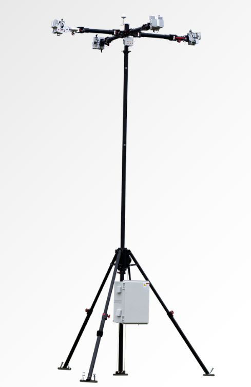
ML300 mobile laser scanning system
Precision surveying in complex environments
The ML300 mobile laser scanning system is designed for large-scale surveying projects and complex environments. It incorporates multi-mode fusion positioning technology, integrating GNSS, IMU, DMI and laser SLAM, providing a new approach to 3D scene reconstruction.
This system is designed for environments where GNSS signals are limited or entirely lost, such as tunnels, urban canyons, and densely built-up areas. In these challenging environments, traditional surveying methods often fail to deliver the required precision, but with ML300’s intelligent multi-mode positioning, we ensure accurate 3D scene reconstruction regardless of the conditions.
The ML300 mobile laser scanning system incorporates multi-mode fusion positioning technology. (Photo: ComNavTech)
The core advantages of the ML300 lie in its high precision and flexibility. By combining Laser SLAM and DMI technologies, it can operate effectively without GNSS signals, eliminating errors and improving modeling accuracy. This breakthrough offers new solutions for large-scale land surveys, urban infrastructure monitoring, and smart city planning, among others.
Designed for operational efficiency, the ML300 boasts a modular and highly flexible design. It can be customized with various sensors, including road cameras, Ladybug 6 panoramic cameras, and wheel encoders, making it adaptable to a wide range of project needs. Additionally, with up to 6 hours of battery life and external power source support, the ML300 ensures stable performance during long working hours.
Whether for highway surveys, urban power line inspections, dynamic forestry management, or smart transportation system development, the ML300 provides precise and efficient data support, facilitating digital transformation across various industries.
The SV3 USV is designed to be portable and usable by a single surveyor. (Photo: ComNavTech)
SV300 unmanned surface vessel
Intelligent underwater surveying
The SV300 unmanned surface vessel was designed specifically for intelligent underwater surveying. This autonomous vessel is optimized for operation in complex aquatic environments, integrating high-precision GNSS positioning, AI technologies, and autonomous navigation capabilities, enhancing both the efficiency and accuracy of hydrographic surveys.
Its design focus on making underwater exploration smarter, safer and more efficient. Its ultra-light design (28 kg) and compact hull (less than 1 meter in length) enable single-person operation. The SV300 can be stored in the trunk of a small vehicle.
Equipped with a high-performance single-beam bathymetric measurement system, the SV300 can measure depths up to 200 meters, ensuring reliable data. Its streamlined hull and powerful motor enable a top speed of 7 meters per second, accelerating survey speeds without compromising accuracy.
The intelligent features of the SV300 enhance measurement efficiency and ensure the safety of personnel. Whether used for river, lake or ocean surveys, or in emergency response and pipeline inspections, the SV300 adapts to complex environments inunderwater exploration.
HYD10 portable echo sounder
Compact and precise
The HYD10 is a lightweight, high-precision echo sounder designed for modern surveying tasks. Weighing 0.3 kg for the main unit and 1.5 kg for the transducer, its portability means a single operator to carry and operate. Its compact design and Bluetooth capability allow it to function seamlessly in tight spaces and complex environments, removing the need for cumbersome cables.
With a measurement depth range of 0.3m to 200 m, the HYD10 provides high-precision readings with accuracy ±1 cm + 0.1% of water depth and 1 cm resolution. The 200 kHz depth module and narrow 6° beam angle ensure precise, clear data, while an adjustable sound speed range (1300-1700 m/s) adapts to different water conditions.
For greater operational flexibility, the HYD10 integrates with Survey Master software, supporting real-time monitoring, data processing and wireless connections through Wi-Fi and Bluetooth. It is compatible with a variety of positioning devices, including the P6H and P8H tablets, as well as a wide range of RTK receivers. The P6H provides centimeter-level positioning accuracy, while the P8H offers flexible antenna adjustments for various field conditions.
The R80 GNSS Data Collector is designed for modern surveying. (Photo: ComNavTech)
R80 GNSS data collector
Precision in surveyors’ hands
The R80 GNSS data collector is designed to improve field technology, engineered for demanding tasks in construction, mining, surveying and GIS. The R80 has an octa-core processor, delivering rapid CAD and map loading to ensure smooth operation and boost productivity. The ergonomic design with an 18-degree grip angle maximizes one-hand comfort, reducing fatigue during long hours of operation.
The R80 features ultra-wide mechanical keys with tactile feedback, offering precise control with a 0.8 mm travel and pressure sensing. It includes custom quick-measure keys for easy access to measurement functions. The 51-key backlit keyboard and a 6-inch 1080P display ensure clear visibility even in direct sunlight. With a 9000 mAh battery, it supports more than 16 hours of continuous operation. It holds an IP67 rating for water and dust resistance and has passed a 1.5-meter drop test.
It supports 4G LTE, Bluetooth, Wi-Fi and NFC, and has a 13MP autofocus camera for high-definition imagery. Survey Master software, integrated with a CADX engine, enables instant opening of large drawings and ensures smooth field operations.
Voyant Photonics is offering new versions of its Carbon lidar platform, adding 32-line and 64-line variants designed to bring the power of frequency modulated continuous wave (FMCW) sensing to more compact, cost-sensitive, and compute-limited systems.
The new models will be on display at the upcoming Consumer Electronics Show (CES 2026) in Las Vegas (LVCC West Hall, Booth #4875). Voyant will demonstrate live FMCW sensing capabilities and provide development kits for qualified partners.
The models complement the existing 128-line configurations, enabling broader choices and customizations from the Voyant portfolio of low-cost, high-performance sensors, and optimized for industrial autonomy, robotics, drones and smart infrastructure applications.
Building on the same efficient semiconductor foundation as Voyant’s flagship Carbon platform, the new versions offer lower data rates and simplified integration without sacrificing core FMCW advantages such as velocity measurement, interference immunity, and high dynamic range.
The Carbon family represents Voyant’s most versatile and scalable lidar product line, designed using Voyant proprietary silicon-photonics architecture that integrates beam steering and coherent detection on a single photonic chip. This integrated technology will unlock mass-production economics, reduced calibration drift, and unmatched consistency from unit to unit, the company said.
The new Carbon variants extend the core Carbon platform’s advantages:
High-precision depth sensing and real time velocity
Exceptional ambient light immunity, ensuring reliability from dim warehouses to direct sunlight
Compact design for demanding industrial and mobile environments
With line resolutions now spanning 32, 64 and 128, OEMs and system integrators can tailor performance, bandwidth and compute load to their specific use cases, from agile robotics and compact AGVs to drones and embedded edge platforms.
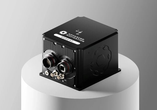
Advanced Navigation has finalized a multi-million deal with Kongsberg Defence & Aerospace to supply more than 50 Boreas D90 fiber-optic gyroscope inertial navigation systems (FOG INS) to strengthen Kongsberg’s Protector RS4 in high-threat, contested environments.
As a strategic-grade INS, the Boreas D90 is engineered for the world’s most extreme environments, maintaining exact targeting and unwavering line-of-sight control for the Protector RS4.
The Boreas D90 was selected not only for its superior precision in GNSS-denied conditions, but also for Advanced Navigation’s proven capacity to meet demanding delivery timelines. This agility is made possible by the company’s state-of-the-art, vertically integrated manufacturing. By controlling the entire production process, from sourcing raw components to assembly and testing in simulated EW environments, Advanced Navigation can rapidly scale output on demand and guarantee schedule certainty, a critical factor for Kongsberg.
The Protector RS4 remote weapon system. Photo: Kongsberg)
The Protector RS4 is the world’s most fielded remote weapon system, deployed across more than 30 nations and multiple domains. The highly flexible, modular system is designed to integrate a diverse range of payloads, including small and medium caliber systems and guided effectors. Its advanced, modular sensor suite (day, night, LRF) provides exceptional and customizable situational awareness.
The fully stabilized 2 + 2 axis (detached line of sight) system allows the operator to maintain focus on a point of interest, independent of platform movement or the delivery solution for the specific system in use. The Protector RS4 is platform-independent and suitable for both land and sea applications.
By integrating Boreas D90, the Protector RS4 achieves a new level of precision and survivability, sustaining locked targeting and georeferenced stability even when GNSS is compromised or denied. This enhancement positions Kongsberg’s Protector RS4 as one of the few systems globally capable of maintaining precision pointing under active electronic warfare attack.
The deal supports the Global Supply Chain (GSC) Program, an initiative by the Australian Department of Defence designed to connect local suppliers with major global defense prime contractors. Advanced Navigation is based in Australia; Kongsberg is based in Norway.
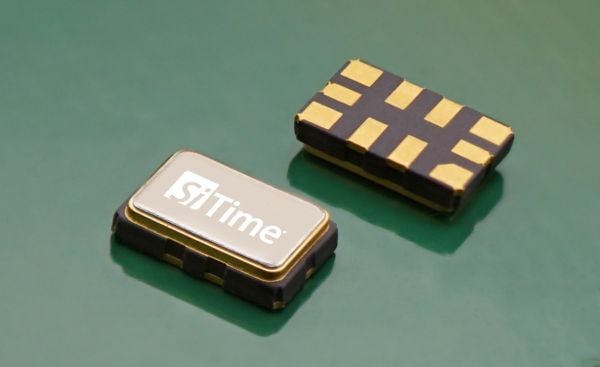
Endura Super-TCXO Delivers Superior Holdover and Ruggedized Performance for Aerospace, Defense and Industrial Applications
SiTime Corporation has launched the Endura temperature-compensated oscillator (Super-TCXO), ENDR-TTT, for position, navigation and timing (PNT) applications. Engineered for superior holdover — uninterrupted operation when GNSS is not available — and resistance to jamming and spoofing, ENDR-TTT is an ultra-stable, low-power product for GNSS receivers in aerospace, defense and industrial markets.
“SiTime’s Endura Super-TCXO, ENDR-TTT, allows us to create a multi-layer anti-spoofing methodology,” said Paul McBurney, GPS World Editorial Advisory Board member, CTO and co-founder at OneNav. “The first layer minimizes the search window, preventing spoofing because signals outside the window are never tracked. The second layer addresses exceptionally large search windows, such as in first acquisition, where spoofers can be tracked. In this case, the spoofer signals can be identified and removed due to SiTime’s ultra-stable reference clock.”
When GNSS signals are dropped because of unavailability or degradation — including signal jamming or extreme environmental conditions — holdover maintains timing stability locally to enable uninterrupted network operation. The ENDR-TTT Endura Super-TCXO provides up to 20x longer holdover and 20x better PNT accuracy, dramatically improving spoofing resistance.
“SiTime’s ENDR-TTT Endura Super-TCXO accelerates GNSS recovery by narrowing the resynchronization window, reducing spoofing and setting a new standard for ruggedized precision timing,” said Piyush Sevalia, executive vice president of marketing at SiTime. “Our latest product delivers a powerful combination of superior performance, low power and small size, that leads the industry for PNT applications.”
Additional features for SiTime ENDR-TTT Endura Super-TCXO include:
±50 ppb stability over temperature (FvT); up to 10x better frequency stability over temperature versus quartz alternatives.
-55ºC to +125ºC operating temperature range.
30,000 g operational shock; up to 20x better resistance to shock.
0.004 ppb/g typical g-sensitivity; up to 50x better than quartz alternatives.
±0.5 ppm 20-year aging—eliminates field recalibration.
Optional I2C/SPI digital pulling capability for system frequency fine-tuning.
SiTime’s ENDR-TTT is sampling now. Mass production is expected in the first quarter of 2026.
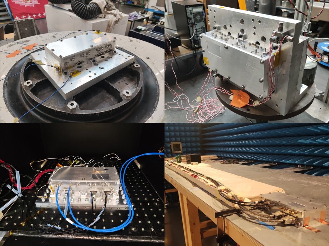
SpacePNT SA, a global provider of high-accuracy, radiation-tolerant spaceborne GNSS receiver equipment for missions ranging from Earth to cislunar orbit, has completed extensive qualification testing of its second-generation product, including vibration, shock, thermal vacuum and electromagnetic compatibility tests.
The multi-frequency, multi-GNSS receiver resulted from two European Space Agency (ESA) ARTES Competitive & Growth (C&G) development projects supported by ESA and the Swiss Space Office.
The first project enabled SpacePNT to develop an industrialized second-generation product for large-scale production targeting low-Earth orbit, LEO position-navigation-timing and geostationary orbit telecommunications constellations. The receiver includes a proprietary Precise Orbit Determination algorithm that provides sub-decimeter real-time positioning and timing aboard spacecraft. The company validated the POD algorithm in a hardware-in-the-loop environment and retrofitted it into two first-generation flight models delivered to a customer for satellite integration.
Under the second project, SpacePNT developed a Radiation Hardiness Assurance approach for long-duration missions in harsh radiation environments. ESA’s GENESIS satellite mission, which will operate in a challenging medium Earth orbit environment, will be the first to use this RHA approach. SpacePNT will supply the mission’s GNSS receiver equipment.
Though the second-generation receiver uses largely the same hardware, software and firmware technology as the company’s flight-proven first-generation product, SpacePNT performed a complete qualification campaign to validate design changes.
After passing all qualification and performance tests, SpacePNT will begin manufacturing first flight models of its second-generation products for several customers. The receivers will fly on demanding Earth observation, in-orbit servicing and space exploration missions at altitudes from LEO through medium Earth orbit, geosynchronous transfer orbit, geostationary orbit and lunar distances.
The views expressed herein do not reflect the official opinion of the European Space Agency.
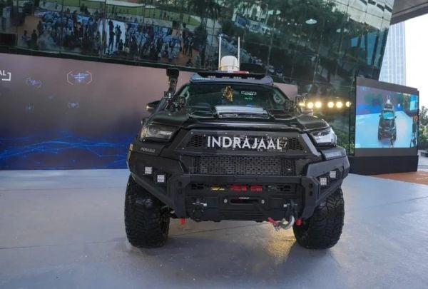
Indrajaal Drone Defence has launched the Anti-Drone Patrol Vehicle (ADPV) — a fully mobile AI-enabled counter-drone system designed to redefine how India responds to drone-led threats.
The Ranger has both soft- and hard-kill options. A GNSS spoofer can hijack drones remotely, while its Zombee interceptor drone provides a kinetic strike capability. Together, the sensors and weapons deliver a 10-kilometer (6.2-mile) detection range and a combat radius exceeding 4 kilometers (2.5 miles).
The urgency to build the ADPV (Indrajaal Ranger) was reinforced when two recent national security incidents demonstrated how drones have become a critical link in breaching India’s border security.
First was a drone-trafficking incident, where weapons were smuggled deep into Indian territory from Pakistan. Second, the Border Security Force neutralized 255 Pakistani drones in 2025, underscoring how drones have become the primary transport channel for drug trafficking.
Breaking away from traditional vehicle-mounted anti-drone solutions that work only when parked, Indrajaal engineered the ADPV ( Indrajaal Ranger) as a purpose-built combat vehicle that delivers:
On-the-move drone detection
Real-time patroling and surveillance
Autonomous threat assessment through AI
Instant interception and neutralization
Seamless coverage across border roads, canals, agricultural belts, critical infrastructure and dense urban pockets.
By intercepting hostile drones, the Indrajaal Ranger prevents narcotics from entering and endangering Indian lives, blocks the inflow of illicit weapons into urban centers, and protects farmers living along sensitive border zones, the company said. Its automated interception framework is designed to reduce the operational load on police units, enabling smarter, data-driven deployment of manpower.
Voyant Photonics has released new versions of its Carbon lidar platform, adding 32-line and 64-line variants designed for compact, cost-sensitive and compute-limited systems.
The new models, which will be displayed at CES 2026 (booth 4875, Las Vegas Convention Center West Hall), complement existing 128-line configurations and are optimized for industrial autonomy, robotics, drones and smart infrastructure applications.
Building on the same semiconductor foundation as Voyant’s flagship Carbon platform, the new versions offer lower data rates and simplified integration while maintaining core FMCW advantages including velocity measurement, interference immunity and high dynamic range.
“With these additions, we’re extending our FMCW lidar to applications where cost and compute budgets are essential and where historically the only available options were over-engineered sensors built for automotive and not designed with industrial needs in mind,” said Clément Kong, vice president of sales at Voyant Photonics. “Carbon 32 and Carbon 64 make it possible for developers to embed true 4D perception in the smallest and most constrained devices, accelerating the shift from autonomous vehicles to autonomous everything.”
Platform capabilities
The Carbon family uses Voyant’s proprietary silicon-photonics architecture that integrates beam steering and coherent detection on a single photonic chip, enabling mass-production economics, reduced calibration drift and unit-to-unit consistency.
The new variants include high-precision depth sensing and real-time velocity measurement, exceptional ambient light immunity and compact design for industrial and mobile environments.
With line resolutions spanning 32, 64 and 128, original equipment manufacturers and system integrators can tailor performance, bandwidth and compute load to specific use cases, from robotics and automated guided vehicles to drones and embedded edge platforms.
According to the company, Voyant’s commercialization strategy focuses on transforming lidar from a niche automotive sensor into a core component of machine perception across industries. Its chip-scale FMCW technology delivers both motion and depth per pixel, enabling spatial reasoning capabilities for industrial automation, robotics, smart infrastructure, logistics and defense.
By partnering with semiconductor foundries and leveraging the global photonics supply chain, Voyant aims to achieve scalability and cost efficiency, opening markets previously closed to traditional time-of-flight lidar solutions.
“We’re entering a new era of physical AI, where devices and machines interpret and interact with the world around them,” said Clément Nouvel, CEO of Voyant Photonics. “Voyant’s vision is to make high-performance 4D sensing as ubiquitous and affordable as any other embedded component, bringing real-world autonomy to every sector.”
Rapid innovation is reshaping GNSS/PNT and positioning, navigation and timing (PNT) landscapes. The same can be said for the channels through which we provide this content to you.
GPS World is making strategic refinements to its magazine publishing schedule and digital solutions portfolio to better serve our subscribers. Our transition from a monthly print and digital edition cadence to a six-times-per-year magazine frequency will better align with buying cycles and industry events.
That’s why the issue you are reading now will be the last of 2025. We will have plenty of new content online daily at GPSWorld.com to keep you informed on trends and new developments in the GPS, GNSS and PNT sectors.
Going forward, GPS World will publish our print issue six times. In 2026, look for issues in February, March, May, June, September and October. We will continue to bring you the same exclusive content, including our Simulator Buyers Guide and our GNSS/PNT Buyers Guide. We’ll have our guest columns, such as Inside the Box. Plus, our popular departments PNT Corner, Evolution, Mapping Marvel, LaunchPad, MarketWatch, System of Systems and Seen & Heard will round out our print editions.
In 2026, our cover stories will tackle transportation, defense, simulators, autonomous systems, precision agriculture and complementary PNT, as well as surveying and mapping. Every GPS World issue will continue to deliver exclusive technical content and market insights — only now, each edition will delve deeper into today’s hottest trends in GNSS/PNT.
In tandem with our magazine content and publishing evolution, GPS World is significantly expanding its digital offerings. New and enhanced digital platforms include:
GPSWorld.com. Watch for more exclusive content focused on the market segments that matter most.
Weekly e-newsletters.Navigate! Weekly, Survey Scene, Defense PNT and Autonomous Arena deliver insightful columns and the latest news straight to your inbox each month.
Custom, sole-sponsored e-newsletters, webinars and digital events. Keep an eye out for turnkey opportunities to showcase thought leadership and new technologies.
These changes reaffirm GPS World’s commitment to being the most authoritative and effective media brand for reaching professionals in the GNSS, PNT and GPS markets. For the past 35 years, GPS World has served readers in print and online, and we have no intention of changing that now. Technology may have evolved over that time, but our dedication to providing you with the latest news and in-depth coverage will continue.