Category: Applications

  • Emcore’s new EN-2000 micro INS ready for defense, UAVs

    Emcore’s new EN-2000 micro INS ready for defense, UAVs

    Photo: Emcore
    Photo: Emcore

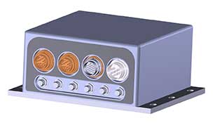
    Emcore Corporation has launched the EN-2000 to the Emcore-Orion series of micro-inertial navigation (MINAV) systems.

    The new EN-2000 will represent the pinnacle of performance in Emcore navigation systems, and realizes the company’s vision of a closed-loop, solid-state design that will deliver higher performance at lower cost than traditional RLG (ring laser gyroscope) navigation systems.

    The EN-2000 expands Emcore’s navigation systems line that also includes the EN-1000 introduced in 2017. The Emcore-Orion series of inertial navigation system (INS) are designed for use in a broad range of defense, aviation and aeronautics applications.

    The unit was introduced at the Paris Air Show, held June 17-20 at the Parc des Expositions Paris-le Bourget in Hall 6, Stand #C65.

    Today, there is an ever-increasing premium being placed on modern navigation systems for improved size, weight and power (SWaP). Traditional RLG navigation systems placed a premium on accuracy and performance, but not SWaP. Typical RLG and FOG systems are large and heavy, ranging in volume from 330 in3 to 540 in3, weighing 13 to 22 pounds with power requirements of 25 to 38 watts.

    Many modern weapon systems are now remotely operated, unmanned or man-portable and may need to operate where GPS is unavailable or denied. The compact EN-2000 is designed for these applications. It puts a premium on accuracy and performance, but also on smaller size, less weight and lower power consumption.

    The new Emcore-Orion EN-2000 MINAV is a three-axis design using the company’s proprietary, next-generation solid-state optical transceiver with advanced integrated optics, combined with all new field programmable gate array (FPGA) electronics to deliver stand-alone aircraft-grade navigator performance at one-third the SWaP of legacy or competing systems.

    The EN-2000 model comes in two standard versions, an IMU version and a standalone INS configuration. The INS version can gyrocompass to less than 0.7 milliradians and maintain near-GPS-level positional accuracy without the use of a GPS receiver. This makes it suitable for use in GPS-denied environments.

    To provide customers with additional flexibility, the unit is also capable of being aided by an external GPS for applications where needed.

    The Emcore-Orion EN-2000 is compact and lightweight, weighing less than 7 pounds, with very low power consumption of 10 watts. It can deliver twice the performance of the EN-1000 with the same form factor.

    The low SWaP of the EN-2000 makes it a suitable inertial navigation system for unmanned aerial vehicles (UAVs), unmanned underwater vehicles (UUVs), unmanned ground vehicles (UGVs), manned aircraft, rotorcraft and dismounted soldier applications.

    “With the introduction of the EN-2000, Emcore can now offer class-leading performance at a fraction of the size, weight and power of competing systems with increased reliability,” said David Faulkner, Emcore vice president and general manager of aerospace and defense. “Emcore’s goal of a true full navigation system that can replace older technology navigation systems in UAVs, UUVs, UGVs, manned aircraft and rotorcraft is fully realized with the introduction of the EN-2000.”

    “Our Emcore-Orion series micro navigators improve dramatically on the size and cost of navigation and azimuth sensing equipment by utilizing affordable lightweight sensors that reduce overall system weight and increase accuracy,” added K.K. Wong, Sr., director of fiber optic gyro products for Emcore. “The digital interface is also fully programmable at Emcore’s factory enabling it to directly replace competing units.”

  • Emcore acquires Systron Donner, increasing defense role

    Emcore acquires Systron Donner, increasing defense role

    Logos: Emcore & Systron Donner

    Emcore Corporation, a provider of advanced mixed-signal optics products that provide the foundation for defense systems, has acquired Systron Donner Inertial, Inc. (SDI) from Resilience Capital Partners for approximately $25.8 million. Consideration will be in the form of $22.8 million in cash plus 810,698 shares of Emcore common stock.

    Highlights of the transaction are as follows:

    • Expected to increase the navigation systems products to over one third of Emcore’s total revenue; making the aerospace and defense market Emcore’s largest revenue source.
    • Expands Emcore’s  navigation systems product portfolio and accelerates growth through the contribution of substantial additional revenue, which in the unaudited books and records of SDI, totaled approximately $28 million for the 12 months ended March 31, 2019.
    • Adds additional Raytheon, Lockheed Martin and Boeing 777X programs to Emcore’s existing navigation systems portfolio.
    • Expected to create material operating synergies in manufacturing, sales and engineering.
    • Expected to be non-GAAP EPS accretive by the end of calendar 2019

    Emcore intends to add SDI’s business to its current navigation product line and support these products from facilities in Concord, California. Through the transaction, Emcore has acquired all of the outstanding assets and liabilities of SDI, including SDI’s 100,000 square foot production facility in Concord.

    “This acquisition delivers immediate scale to our growing navigation systems product line and positions Emcore as one of the largest independent inertial navigation providers in the industry,” said Jeff Rittichier, president and CEO of Emcore. “Merging Emcore’s existing navigation systems product line with SDI’s strong brand, technology and backlog, and program wins, instantly creates a stable, growing, and technically advanced business well-positioned to disrupt market norms.

    “SDI provides Emcore with a scalable, chip-based platform for higher volume gyro applications, while delivering superior performance compared to its competitors. Combining this business into Emcore will allow us to provide customers with a full product suite that serves a broad range of requirements across both the tactical and navigation grade segments of the market,” concluded Rittichier.

    Emcore also announced the appointment of Bruce Grooms to its board of directors. Grooms has extensive senior management and executive experience in both the private sector and the U.S. Navy. From 2015 until June 1, 2019, Grooms served as Raytheon’s vice president of U.S. Business Development, Navy and Marine Corps Programs, where he was responsible for identifying and pursuing U.S. Navy and Marine Corps business growth opportunities for Raytheon and was one of its primary contacts with Navy customers, pursuing opportunities in the evolving cyber area, undersea growth and next-generation strike weapons.

  • Safran and Orolia launch global resilient PNT partnership

    Safran and Orolia launch global resilient PNT partnership

    Logo: Orolia

    Safran and Orolia are partnering to offer the latest resilient positioning, navigation and timing (PNT) solutions for military forces, especially in GNSS-denied environments.

    This partnership will provide mission-critical equipment for air, land, sea and space programs in environments where GNSS signals are not available or degraded. Whether the outage is unintentional or intentional (jamming, meaconing or spoofing), the Safran-Orolia partnership will provide an alternative to GNSS-dependent military systems.

    The Safran-Orolia team will offer military forces an unparalleled convergence of PNT capabilities, including Orolia’s portfolio of precise timing references and PNT sensor-fusion technology, as well as Safran’s proven defense inertial navigation solutions. Initial program priorities include navigation warfare (NAVWAR), along with mobile and fixed PNT solutions.

    “Today’s military operations are increasingly mobile and global, with mission priorities that often bring them into territories where GNSS jamming and spoofing are becoming common threats,” said Orolia CEO Jean-Yves Courtois. “We’re proud to introduce this unique resilient PNT military partnership to better protect and enable mobile operations for NATO and allied countries worldwide.”

    “In a world full of uncertainty, our partnership will provide autonomous and sovereign PNT solutions to Armed Forces facing harsh GNSS denied environments,” said Safran Electronics & Defense Chief Executive Officer Martin Sion.

    Orolia’s PNT solutions improve the reliability, performance and safety of critical, remote or high-risk operations. With locations in more than 100 countries, Orolia provides virtually failsafe GNSS and PNT solutions to support military and commercial applications worldwide.

    Safran is an international high-technology group, operating in the aircraft propulsion and equipment, space and defense markets. Safran has a global presence, with more than 92,000 employees and sales of 21 billion euros in 2018.

  • Raytheon merges with United Technologies aerospace business

    Raytheon merges with United Technologies aerospace business

    logosRaytheon Company and United Technologies Corp. have entered into an agreement to combine in an all-stock merger of equals.

    The transaction will create a systems provider with advanced technologies to address rapidly growing segments within aerospace and defense, the companies said. Raytheon is a defense contractor, while United Technologies is an aerospace company comprised of Collins Aerospace and Pratt & Whitney.

    The combined company, Raytheon Technologies Corporation, will offer a complementary portfolio of platform-agnostic aerospace and defense technologies, expanded technology and R&D capabilities to deliver innovative and cost-effective solutions aligned with customer priorities and the national defense strategies of the U.S. and its allies and friends.

    The merger is expected to close in the first half of 2020, following completion by United Technologies of the previously announced separation of its Otis and Carrier businesses, which are not part of the merger. The timing of the separation of Otis and Carrier is not expected to be affected by the proposed merger and remains on track for completion in the first half of 2020. The merger is intended to qualify as a tax-free reorganization for U.S. federal income tax purposes.

    The combined company will have approximately $74 billion in pro forma 2019 sales.

    Under the terms of the agreement, which was unanimously approved by the boards of directors of both companies, Raytheon shareowners will receive 2.3348 shares in the combined company for each Raytheon share. Upon completion of the merger, United Technologies shareowners will own approximately 57 percent and Raytheon shareowners will own approximately 43 percent of the combined company on a fully diluted basis.

    “Today is an exciting and transformational day for our companies, and one that brings with it tremendous opportunity for our future success. Raytheon Technologies will continue a legacy of innovation with an expanded aerospace and defense portfolio supported by the world’s most dedicated workforce,” said Tom Kennedy, Raytheon chairman and CEO. “With our enhanced capabilities, we will deliver value to our customers by anticipating and addressing their most complex challenges, while delivering significant value to shareowners.”

    “The combination of United Technologies and Raytheon will define the future of aerospace and defense,” said Greg Hayes, United Technologies chairman and CEO. “Our two companies have iconic brands that share a long history of innovation, customer focus and proven execution. By joining forces, we will have unsurpassed technology and expanded R&D capabilities that will allow us to invest through business cycles and address our customers’ highest priorities. Merging our portfolios will also deliver cost and revenue synergies that will create long-term value for our customers and shareowners.”

  • How resilient PNT protects global networks from attack or failure

    How resilient PNT protects global networks from attack or failure

    Time, time, time… See what resiliency brings

    With the smartphone revolution, we are increasingly reliant on today’s global technology networks. The importance of protecting data centers and mobile devices with resilient PNT can’t be overstated. But what is the best way to accomplish this?

    By Rohit Braggs, Orolia

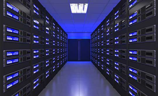
    Connected devices and cloud applications are the primary technology sources for most people today, and an exponentially growing number of those devices are connected to data centers in some way. Across the world, you can drive past countless acres of data centers that are storing, updating and retrieving the world’s data.

    [Editor’s note: A complimentary webinar on Thursday, June 27, “Advanced Simulation Test Systems for Controlled Reception Pattern Antennas,” covers much of this material in greater technical detail. The full webinar is also available for download and viewing after that date.]

    GNSS signals localize and timestamp the data collected from connected devices scattered across the world in diverse time zones and locations. They also provide the critical time synchronization that supports high-efficiency data storage, routing and exchanges across multiple data centers in various locations.

    It is essential to protect data centers and their GNSS signal connections from system failure, jamming, spoofing, interference and denial of service. As the reliance on GNSS signals and the number of connected devices grow, so too does the threat of GNSS failure. False or unavailable positioning, navigation and timing (PNT) information at any point within this network can compromise security and completely disrupt user service.

    This article explores the role of data centers and how their constant connection to devices enables almost every digital technology that we use today. It identifies key reasons why we should protect this interconnected data system from GNSS signal interference and disruption, in addition to providing information on how to ensure continuous signal monitoring and protection with a practical, cost-effective approach.


    See also:

    The latest tech fights for GNSS resilience

    Is internet time good enough for cybersecurity?


    Global Technology Networks

    Data centers and connected devices affect nearly every aspect of our digital lives, from cloud software and applications to mobile phones and laptops. They store our personal documents, photo libraries and other priceless personal data. They also keep track of business documents, software licenses and other essential business information. In critical infrastructure, they support the daily operations of society’s most important services such as public utilities, banking and financial transactions, telecom, security, medical and defense systems, among others.

    Data centers use timestamps as a key mechanism to store, organize and retrieve data. In addition to categorizing data by authorized users and other relevant identification information, the timestamp enables data centers to monitor revisions and retrieve the most recent version of the data.

    A good example of timestamped data use is in cloud-based applications, accessed simultaneously by hundreds of thousands of users. In such environments, data is dynamic and changing frequently, which can lead to data conflicts. With accurate, reliable timestamps, a cloud-based application can resolve such conflicts to determine the order in which the data was received.

    Why do we need to protect data centers and connected devices from GNSS signal interference?

    GNSS signals are the quiet facilitators of many of our day-to-day tasks. In discussing why it is important to protect these signals, it is often easier to imagine what would happen without the accurate, reliable PNT information that these signals provide.

    We need to understand two key pieces of information to operate systems: location and time. We need to know exactly where data or assets are located, and we need reliable, consistent time references to synchronize the movement of data and assets for system operations.

    There are many documented examples of GNSS signal jamming, spoofing and denial of service attacks worldwide, and these are easy to find with a simple internet search. Here are a few examples of what can happen when the signal is compromised at a mobile or fixed location, but not taken offline. The user might still see that the signal is working, with no indication that the two critical pieces of information, location and time, are being disrupted:

    • Imagine that the timestamp on a security camera system was spoofed to show a different time than the actual time. Incorrect or missing timestamps on video from surveillance systems is the most common reason for video evidence being deemed as inadmissible in a court of law. A bad timestamp corrodes the credibility of the video as irrefutable evidence and makes it easy to dispute.
    • Imagine that a bad actor spoofed the time used by financial trading systems. Since these critical systems rely on GNSS-based time and synchronization, an attack on their underlying timing infrastructure could significantly impact the market and cause billions of dollars in damage.
    • What if the GPS guidance system on your phone or vehicle gave you wrong directions? You could get lost in a wilderness or encounter dangerous driving conditions by trusting the route shown on your device.
    • What if more people started using commercially available jammers? Some truck drivers have already been caught using unauthorized GPS jammers in their vehicles to avoid monitoring by their employers. In many cases, these deevices have affected nearby critical systems such as air traffic control, financial data centers, and other critical operations simply by being driven past with active jammers. The incidence of these disruptions is on the rise.
    • Imagine a secure facility using an access control system that is set to automatically lock and unlock doors at a specific time. If someone spoofed the time used by that system, they could trick the doors into unlocking and gain entry.

    We are also seeing an uptick in unintentional or environmental signal interference, which can occur in high-density development areas where various wireless transmitting systems can interfere with GNSS reception.

    Which technology solutions are best suited to protect data centers and GNSS signals?

    The first step toward protecting a GNSS-reliant system is to test the system for vulnerabilities. GNSS simulators and testing protocols can simulate a spoofing, jamming or denial of service attack to evaluate how the system responds to each situation. Knowing the system’s unique challenges and weaknesses can help resilient PNT experts design the best solution for that system.

    One of the most common configurations for a fixed site location includes a highly reliable network time server to ensure that accurate timestamps are applied to each data point. A time server that can identify erroneous or spoofed GNSS signals is recommended for any critical application. In addition, a time series database could be installed to categorize and organize the time-stamped data, while identifying any irregularities in the data.

    Once you have reliable timestamps and time server management systems, you also need to continuously monitor the signal to detect interference and raise an alarm. A GNSS signal monitoring system can let you know the minute your system is under attack. A GNSS threat classification system can identify the type of threat and mitigate it, depending on the nature of the threat, by filtering the signal to neutralize the interference.

    The best way to prevent GNSS jamming is to deny interfering signals access to the receiver in the first place. Smart antenna technology focuses antenna beams to track the good signals from the satellites and reject the bad signals from interferers. Less sophisticated solutions such as blocking antennas can be employed to reject terrestrial-based interference, which is where most GNSS interference sources exist, and they provide a good first-level protection.

    Continuous PNT access can also be achieved by using an alternative signal that operates separately from GPS/GNSS and is less vulnerable to the signal attacks that plague GNSS signals.

    Emerging PNT Technologies

    Over the next few years, new applications of mobile PNT data will further emphasize the need to maintain system integrity against threats. Here are a few examples of emerging technologies.

    5G is here for mobile Internet and telecom service, yet with the specific need for microsecond-level synchronization, the challenge to protect the fidelity of the time used in these systems will become more important.

    With rising awareness of the need to protect GNSS signals against threats, individuals will need to determine how they can protect their own GNSS-reliant systems as they navigate the Internet of Things and GIS enabled e-commerce. Personal PNT protection is an emerging technology area that could help protect people and their mobile devices on an individual basis, to ensure GNSS is there when it matters. Whether you are embarking on a remote hiking or sea expedition, sharing your coordinates with an emergency dispatcher after an accident, or simply trekking your way through a new city late at night, having resilient GNSS signal support is becoming a necessity.

    Alternative signals are now available, and these new signal options, such as STL (Satellite Time and Location), could play an important role in providing better privacy and security functionality. This signal diversity will help protect against threats and interference by adding resilience to the device’s ability to receive reliable PNT data.

    Another exciting technology development is the concept of smart cities, where technology has the opportunity to increase efficiency, reduce waste and provide many conveniences for the public. As we automate more city systems, it is essential to protect these systems from both accidental and malicious GNSS-based interference to ensure that these systems can make decisions based on reliable, precise PNT data.

    Intelligent Transportation Systems (ITS) have the capacity to transform how people and freight travel today, saving lives and bringing goods to market more efficiently than ever. The need to know exactly where a driverless vehicle is in relation to other vehicles at any moment in time is just one of the resilient PNT technology requirements that will rely on GNSS signals.

    Finally, authenticated time and location information can help increase cybersecurity for many applications, by limiting data access to a very specific window of time and only in a precise location. This is an area of cybersecurity which has the potential to add new layers of authentication to protect users and their data. With connected devices at the forefront of our access to the world, secure and reliable PNT technologies are more critical than ever.

    These are just a few examples among many of the new technology innovations that are in the works to provide us with new benefits in leaps and bounds.

    Protecting Our Virtual Brain

    Data centers are the technology hubs of today, and their constant connection to devices fuels our ability to access critical information instantly. This networked system serves as a virtual brain that holds our personal memories, charts our progress, enables us to share results and helps us deliver new technology advancements faster than we could ever do before.

    As we prepare to embrace our new technology, we should first address the PNT technology challenges of today and ensure that our GNSS signals are resilient and reliable. With this strong foundation in place, we can better protect our current systems and keep pace with evolving threats that would otherwise jeopardize the functionality, safety and security of these new capabilities.


    Rohit Braggs is the chief operating officer at Orolia. Based in Rochester, New York, he is responsible for the development and execution of the company’s global business strategy and corporate initiatives. He also serves on the board of directors for Satelles Inc., which provides time and location solutions over the Iridium constellation of low-Earth-orbiting satellites.


  • The latest tech fights for GNSS resilience

    The latest tech fights for GNSS resilience

    Image: Harxon
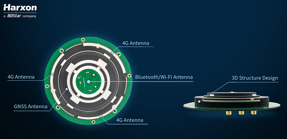
    Architecture of the X-Survey antenna. (Image: Harxon)

    Blocking interference

    Interference can be blocked at the data-collection stage, using an advanced antenna.

    Harxon’s X-Survey is a compact high-precision GNSS antenna. It provides superior navigation and communication performance in surveying applications. A frontal band-pass filter setting effectively rejects out-of-band signals before they enter the low-noise amplifier of the antenna for signal augmentation.

    Meanwhile, the filter itself has insertion loss, making a low insertion loss filter a prerequisite for optimal system noise reduction. To avoid this situation, X-Survey employs ceramic filter with low signal loss and in-band flatness to significantly improve system anti-interference capability and ensure reliable signal receiving.

    The mosaic module provides AIM+ mitigation technology. (Image: Septentrio)
    The mosaic module provides AIM+ mitigation technology. (Image: Septentrio)

    See also:

    How resilient PNT protects global networks from attack or failure

    Is internet time good enough for cybersecurity?


    Resilient receivers

    Septentrio began to tackle the interference problem more than 20 years go, designing and manufacturing high-precision GNSS receiver technology with emphasis on reliability and robustness. The result is Advanced Interference Monitoring and Mitigation (AIM+) technology which secures the company’s GNSS receivers against jamming and spoofing interference. AIM+ has recently been upgraded with an extended anti-spoofing functionality.

    Building on its existing spoofing detection, Septentrio has developed a new anti-spoofing algorithm for its commercial receivers. The algorithm leverages Galileo Open Service Navigation Message Authentication (OSNMA) for spoofing resistance. It was developed in the framework of the GSA FANTASTIC project with the goal of improving the security of timing in critical infrastructure.

    Mobile devices and cloud applications increasingly rely on GNSS technology used by telecom companies. Having secure and robust GNSS receivers in telecom infrastructure is key to reliable mobile and positioning services.

    Alternative signals

    Prototype design of the PNT-5500. (Image: Jackson Labs)
    Prototype design of the PNT-5500. (Image: Jackson Labs)

    A new reference receiver, Jackson Labs PNT-5500, includes a custom Satelles/Iridium (STL) and GPS receiver, and an optional Edge Grandmaster/PTP1588 capability.

    Using STL signals received directly through a small antenna mounted on the device, the PNT-5500 provides nanosecond timing synchronization in GPS-challenged environments, including deep indoors (no rooftop antenna required). It provides secure timing during GPS jamming and spoofing events. The unit is designed for high-volume, low-cost telecom small-cell synchronization, and is optionally available with holdover oscillators such as DOCXO and CSAC atomic clocks.

    While GPS is vulnerable to jamming and spoofing, the PNT-5500 uses the Iridium infrastructure to provide assured timing that is impervious to spoofing and provides 1,000X higher signal strength compared to GPS, producing jamming resilience and deep-indoor reception. The system is designed to be fully interoperable with legacy equipment, for a low-cost, fully-deployed Assured PNT capability alternative to GNSS today.

    Assessing vulnerability

    Image: Qascom
    Image: Qascom

    Qascom offers several robust PNT services and products, including vulnerability assessment, robust navigation and interference localization.

    Vulnerability assessment is the key proactive measure, using cutting-edge signal generators to design and test tomorrow’s receivers. For example, Qascom’s QA707 GNSS simulator tests receivers against emerging jamming and spoofing threats, allowing OEMs to discover in advance any potential vulnerability that may affect the availability and the integrity of the signal.

    Robust navigation is supported by advanced mitigation algorithms, equipped with pre and post-correlation algorithms, as well as the inclusion of sensor fusion and dead-reckoning features.

    Qascom’s attack detection products include external monitoring networks that support GNSS receivers. These networks provide an accurate perception of the operational environment, allowing threat characterization, classification and forecast. For instance, Qascom’s QB100 enables the simultaneous threat detection and localization by means of a monitoring cluster that delivers 24/7 situational awareness to a set of target receivers within the protection area.

    Reliable timing

    Meinberg provides GNSS timing solutions for nearly every application type. Its reliable systems are based on firmware built from the ground up by an in-house team of expert engineers. All Meinberg firmware is constantly checked and updated to ensure it adapts to evolving industry standards.

    The company’s synchronization systems use a built-in Meinberg GPS receiver or combined GPS/GLONASS clock. They also support a broad range of reference time sources, including 1 PPS, 10 MHz, inter-range instrumentation group time codes (both direct current level shift and amplitude modulated), or network time protocol (NTP) servers. This redundancy in synchronization sources means Meinberg’s systems are protected against a loss of signal. Furthermore, to ensure the correctness of the reference time and date, an intuitive Secure Hybrid System (SHS) feature includes an independent secondary clock for enhanced plausibility checks.

    For superior holdover performance, the Meinberg XHERB (with one or two Rubidium modules from Stanford Research) can be added to the Meinberg Intelligent Modular Synchronization (IMS) time and frequency systems. If the reference clock loses its sync source, the XHE chassis will provide the sync reference for the IMS chassis based on its holdover performance.

  • Is internet time good enough for cybersecurity?

    Is internet time good enough for cybersecurity?

    By Jeremy Onyan, Director, TIme Sensitive Networks, Orolia

    Cybersecurity is critical to all facets of the internet. Companies spend millions on cybersecurity every year. Still, often-overlooked areas degrade security. A key example of this is time.

    Time plays an essential role in synchronizing core business and network systems. It supports authentication protocols as well as accurate log files critical for an audit trail — necessary for any cyber forensics program. As such, synchronization is often a requirement for network security standards.

    A deployment of network time protocol (NTP) synchronizes a local system to a time server. The time source can come from within the network or outside of it.


    See also:

    How resilient PNT protects global networks from attack or failure

    The latest tech fights for GNSS resilience


    NTP over the internet. NTP time servers are widely available on the internet. National authorities operate internet time servers based on extremely accurate atomic clocks, such as the National Institute of Standards and Technology (NIST) or the U.S. Naval Observatory.

    But even with these sources, many factors impact traceability. According to ntp.org, “If business, organization or human life depends on having correct time or can be harmed by it being wrong, you shouldn’t ‘just get it off the internet’.”

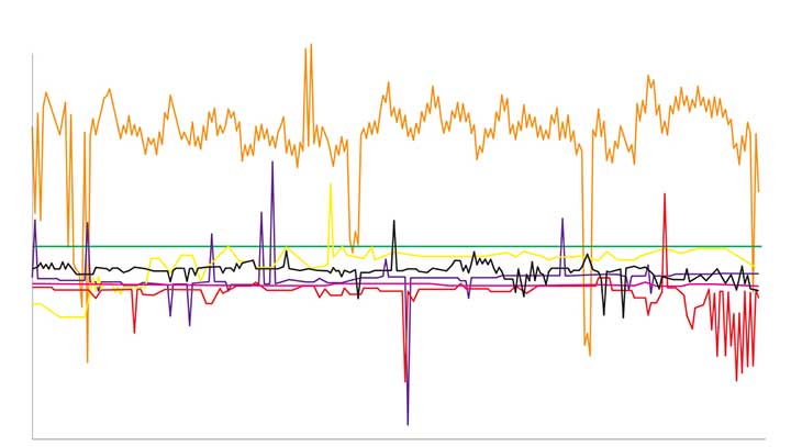
    One problem with time synchronization is the variability of network conditions. Network load, variable path delays and firewall settings can impact time quality on the local system. To illustrate this effect, we can use the time-quality monitoring feature of a time server with a built-in GPS receiver as its reference that is accurate to tens of nanoseconds. NTP can be used to compare it to another GPS time server on a local area network. The offset is around 15-20 microseconds (Figure 1).

    Figure 1. The comparison between two GPS time servers on the same LAN using NTP results in 15–20 microseconds offset. (Chart: Orolia)
    Figure 1. The comparison between two GPS time servers on the same LAN using NTP results in 15–20 microseconds offset. (Chart: Orolia)

    We connected the SecureSync time server to some of the most popular internet time servers. The variation result, shown in Figure 2, is as high as tens of milliseconds — 1,000 times worse than NTP across a local area network. If we assume all the time servers are accurate, then the difference is solely due to greater path delay and other dynamic conditions. This variation is enough to question the traceability of time from the internet.

    Figure 2. The comparison of internet time servers as measured by NTP on a local GPS time server. The scale is 1,000 times greater than in Figure 1. (Chart: Orolia)
    Figure 2. The comparison of internet time servers as measured by NTP on a local GPS time server. The scale is 1,000 times greater than in Figure 1. (Chart: Orolia)

    The internet obscures time traceability. Perhaps more important for a security-critical network is the validity of the source used by the time server that distributes time to your network. Time from GPS/GNSS signals is recognized as the most accurate, available and traceable time source.

    GPS/GNSS-based time servers are easy and simple appliances to add to the local network. Even when different GPS/GNSS time servers are deployed in different locations, they will provide the same time regardless of geography. What’s more, GPS/GNSS as a local time source can be monitored, so its logs can become part of the audit trail.

    Of the seven internet time servers monitored over a 24-hour period, 20 different time sources were identified. Less than half of the sources could be identified as coming directly from GPS/GNSS. In one case, GPS/GNSS time was distributed through three different time servers.

    The best practice of using NTP server pools is one reason why there are more sources than time servers. Server pools rotate among various internet time servers, each with their own source of time, to reduce the chance of one bad or unavailable time server catastrophically affecting the synchronization. But this is a problem for traceability. The source of time is not known, nor can it even be determined.

    Indeterminate source identification, indeterminate accuracy variation and the inability to log the resulting time synchronization calls into question the efficacy of getting time from the internet. Internet time servers are also subject to being spoofed (bad NTP data sent from a faked IP address) and to direct attacks, including NTP poisoning, replay and denial of service.

    When there is a business-critical need to trace time to an accurate source, a GPS/GNSS-based time server should be deployed on the local network.

  • Editorial Advisory Board PNT Q&A: Keeping data safe

    Editorial Advisory Board PNT Q&A: Keeping data safe

    What is the best way to protect data centers and mobile devices from spoofing and jamming?

    Ellen Hall
    Ellen Hall

    “After speaking to our head of engineering, Roger Hart, he explained this as something akin to ‘What’s the best way to achieve world peace?’ As the strengths and vulnerabilities of static and mobile devices vary considerably, the best solution will be achieved through a tailored application of algorithms, antenna siting and design, multi-constellation, multi-frequency and non-GNSS inputs.”
    Ellen Hall
    Spirent Federal Systems


    Allison Brown
    Allison Brown

    “Spoofing and jamming presents a very credible threat today to users of GPS for navigation and perhaps the greatest threat is vulnerability within our national infrastructure to spoofing of GPS timing. Congress, recognizing this threat, has tasked the Department of Transportation (DOT) in the National Timing Resilience and Security Act of 2017 to provide a backup for the timing component of the GPS. Specifically this backup is to ‘ensure the availability of uncorrupted and non-degraded timing signals for military and civilian users if GPS timing signals are corrupted or otherwise unavailable.’ Although the act directed the DOT that this system should be operational in two years (2019), little progress appears to have yet been made in deploying a backup timing system. This system not only would reduce vulnerability to spoofing for timing users, but could also be used by mobile users for detection of spoofing, allowing for national alerting when jamming or spoofing is detected. These alerts, tied with a quick response mechanism for law enforcement to take action, would provide an effective method for protecting all GPS users nationwide from jamming or spoofing.”
    Alison Brown
    NAVSYS Corporation


    Jean-Marie Sleewaegen
    Jean-Marie Sleewaegen

    “Take full benefit of multi-frequency multi-constellation redundancy.  Perform signal monitoring and authentication using advanced receiver architectures and signal-based protection (e.g., Galileo’s Open Service Navigation Message Authentication). Foresee non-GNSS redundancy to bridge gaps, such as precise clocks for data centers or IMUs for mobile devices.”
    Jean-Marie Sleewaegen
    Septentrio


    Members of the EAB

    Tony Agresta
    Nearmap

    Miguel Amor
    Hexagon Positioning Intelligence

    Thibault Bonnevie
    SBG Systems

    Alison Brown
    NAVSYS Corporation

    Ismael Colomina
    GeoNumerics

    Clem Driscoll
    C.J. Driscoll & Associates

    John Fischer
    Orolia

    Ellen Hall
    Spirent Federal Systems

    Jules McNeff
    Overlook Systems Technologies, Inc.

    Terry Moore
    University of Nottingham

    Bradford W. Parkinson
    Stanford Center for Position, Navigation and Time

    Jean-Marie Sleewaegen
    Septentrio

    Michael Swiek
    GPS Alliance

    Julian Thomas
    Racelogic Ltd.

    Greg Turetzky
    Consultant

  • GPS monitoring and crimes that shouldn’t have happened

    GPS monitoring and crimes that shouldn’t have happened

    Headshot: Tracy Cozzens
    Tracy Cozzens

    Law enforcement agencies have been quick to adopt GPS monitoring of offenders on parole or awaiting trial. An estimated 300,000 people in the U.S. are wearing ankle bracelets. Proponents say the systems enhance public safety, reduce prison costs and provide social benefits.

    However, technology is only as good as the people who use it, as a tragic case from Ohio illustrates. In February 2017, 21-year-old Reagan Tokes was kidnapped and murdered after leaving work in Columbus. The man convicted of killing her had been recently released from prison. Yes, he was wearing a GPS monitor, but no one was tracking his movements until after he robbed six people and killed Tokes.

    In response, Ohio lawmakers introduced a bill to improve real-time monitoring of parolees by shrinking the workload for parole officers, who now are responsible for 90 to 100 offenders at one time.

    In cases in Florida and New York, the system worked as intended and alerts were sent, but authorities took no action. In the Florida case, no one was on duty, despite the suspect having triggered more than 100 alarms.

    An offender in Syracuse, New York, was able to remove and reassemble his ankle bracelet in less than a minute, using techniques he learned when he watched the officers put the bracelet on him. Because of numerous false alarms, the monitoring company had set a five-minute limit before officers were notified, at the police department’s request. Having beat the monitoring system, the offender committed a murder.

    A nationwide investigation by ABC’s “20/20” news magazine program found at least 50 murders allegedly committed since 2012 by people ordered to wear monitored ankle bracelets.

    “Public safety is only as good as the supervising entity we provide our products to,” Jennifer White of monitoring company BI Analytics commented on “20/20.” Criminal justice experts say the monitoring system should not be used for anyone who is a risk to the public.

    While policymakers and law-enforcement authorities determine the most effective use of such systems —and how to address issues of monitoring response, overtaxed officers and tight budgets — the monitoring industry continues to improve the “tamper-resistant” devices as well as the services offered.

    After all, no one wants to live with a false sense of security.

  • Tersus launches dual-antenna GNSS receiver with heading

    Tersus GNSS Inc. has launched the David Plus — a dual-antenna GNSS receiver that offers centimeter-accurate positioning and heading. It is designed for intelligent transportation, construction, machine control, precision agriculture and navigation applications.

    David Plus is designed for efficient and rapid integration. The compact, lightweight receiver tracks GPS, GLONASS and BeiDou signals: GPS L1/L2, GLONASS L1/L2, BeiDou B1/B2 from the primary antenna, and GPS L1/GLONASS L1 or GPS L1/BeiDou B1 from the secondary antenna.

    The modular and flexible design can provide robust positioning and heading accuracy in a compact footprint for UAVs and other smaller autonomous projects.

    The David Plus GNSS receiver is built for outdoor environments with IP67-rated enclosure. Its compact palm-sized design makes it easy to integrate with various application systems.

    Four gigabytes of in-built memory are available to record data for post-processing.

    The David Plus GNSS receiver supports RTK positioning mode or RTK positioning + heading mode. It supports 384 channels. It’s easy to connect an external powerful radio for long range communication.

  • K2 will drive GLONASS under 1M

    K2 will drive GLONASS under 1M

    New GLONASS-K2 satellites will improve the accuracy of Russia’s satellite navigation system from 3-5 meters to less than 1 meter, said Chief Designer Mikhail Korablyov of the Joint Stock Company GLONASS, operator of the ERA-GLONASS traffic accident emergency response system, at a transport conference in Moscow in late May.

    Russia plans to launch the first K2 satellite in late 2019 or early 2020. By 2030 the GLONASS constellation will consist wholly of K2 space vehicles, 24 of them.

    The improved accuracy will better determine vehicle location in analyzing a traffic accident, according to Korablyov. It will not, however, be sufficient for lane-keeping and other advanced driver assistance systems, nor for more stringent autonomous driving requirements, at least according to emerging Western standards.

    “There are also tasks linked with the country’s defense, there are special precision weapons, the requirements for which already make up less than a meter,” Korablyov added.

    Yury Urlichich, First Deputy Director General, Roscosmos. (Photo: Roscosmos)
    Yury Urlichich, First Deputy Director General, Roscosmos. (Photo: Roscosmos)

    Numbers. Writing in the December 2018 issue of GPS World, Yury Urlichich, First Deputy Director General, Roscosmos State Space Corporation, gave a somewhat more precise figure for the new accuracy to be achieved via the K2 generation. “The new signals will allow lowering the hardware-dependent SC-user ranging error by an order of magnitude, reducing the influence of signal reflections from buildings, constructions and landscape (multipath effect), thus enabling their effective use for high-precision navigation with real-time errors below 0.1 m.

    “This SC will enable navigation not only using legacy FDMA signals available for users for more than 35 years, but simultaneously with a full row of CDMA signals in all GLONASS frequency bands: L1, L2 and L3.”

    Later in the same piece, Urlichich wrote “Mission Definition Requirements for Glonass-K2 define user range error to be 0.3 m, qualitatively improving GLONASS user performance.”

    The new K2 satellite will transmit nine navigation signals and will weigh about 1,800 kg, twice as much the latest GLONASS-K generation, known as K1. Of the 24 currently orbiting operational satellites, only two are K1 space vehicles. The other 22 are older GLONASS-M satellites.

    A Shock to the System. A bolt of lightning struck the rocket launcher for the latest GLONASS-M satellite to rise, on May 27. It did not adversely affect the bird’s journey to space, and all systems were found to be functioning properly once the satellite was released into preliminary orbit, Russian space officials said.

  • Landviewer’s new change detection tool runs in a browser

    Landviewer’s new change detection tool runs in a browser

    A major use of remote sensing data is to compare images of an area taken at different times and identify the changes it underwent. With a wealth of long-term satellite imagery in open use, detecting such changes manually would be time-consuming and most likely inaccurate.

    To address this, EOS Data Analytics has introduced an automated Change Detection tool to its flagship product LandViewer, a cloud tool for satellite imagery search and analysis in today’s market.

    Unlike the methods involving neural networks that identify changes in the previously extracted features, the change detection algorithm implemented by EOS is using a pixel-based strategy, meaning that changes between two raster multi-band images are mathematically calculated by subtracting the pixel values for one date from the pixel values of the same coordinates for another date.

    This new signature feature is designed to automate a change detection task and deliver accurate results in fewer steps and in a fraction of the time needed for change detection in most image-processing software.

    Change detection interface: Images of Beirut city coastline selected for tracing the developments of the past years. (Image: LandViewer)
    Change detection interface: Images of Beirut city coastline selected for tracing the developments of the past years. (Image: LandViewer)
    Change detection interface: Images of Beirut city coastline selected for tracing the developments of the past years. (Image: LandViewer)
    Change detection interface: Images of Beirut city coastline selected for tracing the developments of the past years. (Image: LandViewer)

    Applications from farming to environmental monitoring

    One of the main goals set by EOS team was to make the complex process of change detection in remote sensing data equally accessible and easy for non-expert users coming from non-GIS industries.

    With LandViewer’s change detection tool, farmers can quickly identify the areas on their fields that were damaged by hail, storm or flooding. In forest management, satellite image detection of changes will come in handy for estimation of the burned areas following the wildfire and spotting the illegal logging or encroachment on forest lands.

    Observing the rate and extent of climate changes occurring to the planet (such as polar ice melt, air and water pollution, natural habitat loss due to urban expansion) is an ongoing task of environmental scientists, who may now have it done online in a matter of minutes. By studying the differences between the past and present using the change detection tool and years of satellite data in LandViewer, all these industries can also forecast future changes.

    Top change detection use cases: Flood damage and deforestation

    A picture is worth a thousand words, and the capabilities of satellite image change detection in LandViewer can be best demonstrated on real-life examples.

    Forests that still cover around a third of the world’s area are disappearing at an alarming rate, mostly due to human activities such as farming, mining, grazing of livestock, logging, and also the natural factors like wildfires. Instead of massive ground surveying of thousands of forest acres, a forestry technician can regularly monitor the forest safety with a pair of satellite images and the automated change detection based on NDVI (Normalized Difference Vegetation Index).

    How does it work? NDVI is a known means of determining vegetation health. By comparing the satellite image of the intact forest with the recent one acquired after the trees were cut down, LandViewer will detect the changes and generate a difference image highlighting the deforestation spots, which can further be downloaded by users in JPG, PNG or TIFF format. The surviving forest cover will have positive values, while the cleared areas will have negative ones and be shown in red hues indicating there’s no vegetation present.

    A difference image showing the extent of deforestation in Madagascar between 2016 and 2018; generated from two Sentinel-2 satellite images. (Image: LandViewer)
    A difference image showing the extent of deforestation in Madagascar between 2016 and 2018; generated from two Sentinel-2 satellite images. (Image: LandViewer)

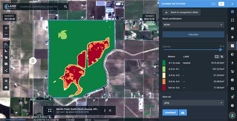
    Another widespread use case for change detection would be agricultural flood damage assessment, which is of most interest to crop growers and insurance companies. Whenever flooding has taken a heavy toll on your harvest, the damage can be quickly mapped and measured with the help of NDWI-based change detection algorithms.

    Results of Sentinel-2 scene change detection: The red and orange areas represent the flooded part of the field,; the surrounding fields are green, meaning they avoided the damage. California flooding, February 2017. (Image: LandViewer)
    Results of Sentinel-2 scene change detection: The red and orange areas represent the flooded part of the field,; the surrounding fields are green, meaning they avoided the damage. California flooding, February 2017. (Image: LandViewer)

    How to run change detection in LandViewer

    There are two ways you can launch the tool and start finding differences on multi-temporal satellite images: by clicking the right menu icon “Analysis tools” or from the Comparison slider ‒ whichever is more convenient. Currently, change detection is performed on optical (passive) satellite data only; addition of the algorithms for active remote sensing data is scheduled for future updates.

    A guide to LandViewer is available here.