Image-based positioning has not yet been certified in aviation applications. To cover numerous environmental conditions, the authors installed various optical sensors. They present an approach for fusing image data of two complementary cameras with different spectral ranges.
The use of two image sensors working in the visible light spectrum and infrared spectrum increases availability and accuracy, meeting requirements to be used as an augmentation for state-of-the art GNSS-based landing systems.
This investigation presents real flight data processed by means of the proposed method. This work constitutes a new approach for robust runway detection, since position calculation was only carried out once in one time epoch on a single blended image.
The proposed method was applied to data from two flight campaigns in post-process. A determined set of parameters lead to a sufficient level of availability and a valid runway detection throughout the final approach.
Citation
M. Angermann, S. Wolkow, A. Dekiert, U. Bestmann, P. Hecker (2018), “Linear blend: Data fusion in the image domain for image-based aircraft positioning during landing.” Pacific PNT Conference,www.ion.org/publications/browse.cfm
Aircraft navigation during landing approach is mostly supported by ground-based landing systems in commercial aviation, which cause high installation and maintenance costs.
Nevertheless, the final sequence of the flight before touchdown is mostly performed by the pilot manually, because of the high requirements for accuracy and integrity. Only a few landing systems can fulfill these requirements during the last 200 feet above ground.
The current work presents a further development of an optical positioning system to be deployed below 200 feet and on ground after touchdown in order to be used as an additional source for positioning information. The system is capable of visual 3D positioning of the aircraft relative to the runway.
Algorithms for threshold marking (see image below) and centerline detection, as well as lateral position calculation during rollout are presented. The system is evaluated during flight trials performed with the research aircraft Dornier Do 128-6.
Citation
S. Wolkow, M. Angermann, A. Dekiert, U. Bestmann (2018), “Model-based threshold and centerline detection for aircraft positioning during landing approach.” Pacific PNT Conference,www.ion.org/publications/browse.cfm
I was inspired by the 50th anniversary of the Moon landing on July 16 and our focus on mapping this month to look into imagery of the Moon.
Only recently have we learned that the lunar orbiters that photographed the Moon in the 1960s sent back images that were stunningly high resolution (HR), even by today’s standards. The actual resolution was presumably kept secret because the imaging technology was also used in our Cold War spy satellites.
Under the Lunar Orbiter Program, satellites took photographs of the Moon’s surface to identify suitable landing sites for the Apollo Program. Managed by the Langley Research Center, five Lunar Orbiters were successfully flown in 1966 and 1967, mapping 99% of the Moon’s surface with a resolution of 60 meters or better.
The first three missions were dedicated to imaging 20 potential landing sites, and were flown at low-inclination orbits.
The fourth and fifth missions were devoted to broader scientific objectives and were flown in high-altitude polar orbits. Lunar Orbiter 4 photographed the entire nearside and 95% of the farside, and Lunar Orbiter 5 completed the farside coverage and acquired medium (20-meter) and high (2-meter) resolution images of 36 pre-selected areas.
In that pre-digital era, the Lunar Orbiters had an ingenious imaging system, which consisted of a dual-lens camera, a film processing unit, a readout scanner and film-handling apparatus. Both lenses, a 610-mm narrow angle HR lens and an 80-mm wide-angle medium resolution (MR) lens, placed their frame exposures on a single roll of 70-mm film.
The axes of the two cameras were coincident so the area imaged in the HR frames were centered within the MR frame areas.
The film was moved during exposure to compensate for spacecraft velocity, which was estimated by an electric-optical sensor. The film was then processed, scanned, and the images transmitted back to Earth. Based on these images, the NASA Apollo Site Selection Board would name five candidate landing sites in February 1968.
Terra Drone Brazil, a group company of Japan-based Terra Drone Corp., has successfully completed Brazil’s first drone inspection of an offshore FPSO tank. The unmanned FPSO tank inspection was undertaken for Brazil’s state-owned oil company Petrobras.
The ballast tank inspection using drones was conducted aboard P-66, a floating production, storage and offloading (FPSO) unit from Petrobras that is operating in the Pre Salt Area at Santos Basin. An FPSO is a floating vessel used by the offshore oil and gas industry for the production and processing of hydrocarbons, and for the storage of oil.
Petrobras needs its cargo and ballast tanks inspected regularly for maintenance. Any kind of corrosion, cracks, fractures or welding anomalies must be identified quickly before they can damage the structural integrity of the ship.
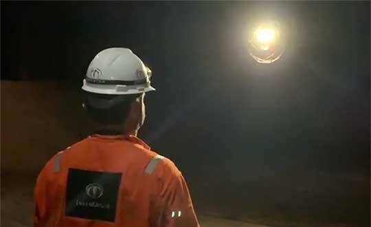
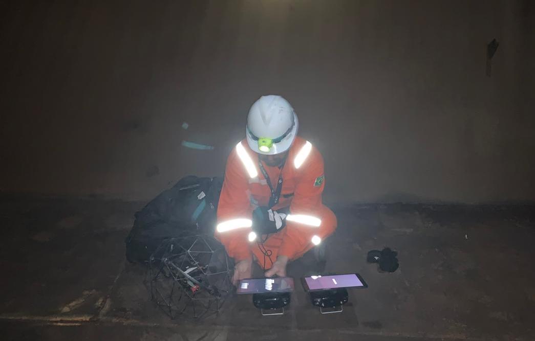
The drones are prepped for the tank inspection. The UAV inspection just over an hour. (Photo: Terra Drone)
Traditionally, this inspection is done by sending a team of up to four men inside the confined tank space using scaffolds or rope access. This kind of close-up visual inspection of one tank alone can take from half a day to a full day, and pose a safety threat to the workers inside the tank.
Using drones reduces the need for workers to enter the tank. “Not only is unmanned FPSO tank inspection safer, but it is also much quicker and more precise than manual inspection,” said Marcelo Belleti, executive director at Terra Drone Brazil. “Further, drone inspections for cargo tanks can lead to potential cost-savings as well.”
Terra Drone Brazil completed the inspection of a ballast tank for Petrobras in little over an hour with a team of only two men. The high-definition pictures and videos captured by the drone ensured a quality deliverable report for all 40 points pre-defined for the close-up inspection.
Terra Drone Brazil is certified by ABS (American Bureau of Shipping), DNV GL (Det Norske Veritas and Germanisher Lloyds) and Loyd’s Register as a service supplier approved for surveying using Remote Inspection Techniques (drones) as an alternative means for a close-up survey of the structure of ships and mobile offshore units. The Petrobras P-66 is ABS-certified.
Data from Earth Monitor reveals the number of cars and trucks in an area of Amsterdam. (Image: Airbus)
The new Earth Monitor tool draws from the Airbus imagery archive and satellite tasking capabilities to provide advanced geospatial analysis, trends and detection maps.
Available as part of Airbus’s OneAtlas suite of geospatial tools, Earth Monitor enables customers to draw precise, timely and meaningful conclusions. It uses Orbital Insight’s machine learning and computer vision expertise through algorithms that detect changes in infrastructure and land use in near-real time. It can identify and count objects such as cars, trucks, roads, homes, buildings and construction sites and, soon, aircraft.
Earth Monitor can identify trends, spot patterns and track economic activity, delivering advanced geospatial analysis and change-detection maps on customized areas of interest to users in defense, intelligence and law enforcement.
Earth Monitor comes from a collaboration between Airbus Defense and Space, a French aerospace company, and Orbital Insight, a Silicon Valley startup. The OneAtlas platform combines Airbus’ constellation and tasking services with Orbital Insights’ analytic capabilities.
Orbital Insight’s algorithms draw on petabytes of data from multiple sources, such as satellite and synthetic aperture radar imagery, geolocation intelligence and vessel traffic data.
The tool’s interface enables users to create and manage projects, customize analyses and define period and measurement frequencies.
Arvento’s imt.x1 has a six-axis gyro sensor that can sense three-dimensional movement caused by emergency acceleration, panic braking and directional yaw and drift.
With connectivity options including dual CANBus and Bluetooth, the system is also eCall compatible and captures and provides data for accident analysis and other vehicle tracking functions. The system also uses the next-generation powerful Arm-based microcontroller.
This latest launch is yet another product of a successful, eight-year strategic partnership between Arvento and u-blox. “U-blox is more than a supplier,” said Özer Hıncal, Arvento’s general manager. “As a global leader in the IoT [internet of things] industry providing high-performance IoT modules, platforms and support services, u-blox is our trusted solutions partner, working closely with us to address customer demands and issues.”
As for previous Arvento products, collaboration with u-blox was a key factor in the imt.x1 product development process. The system’s high position sensitivity and accuracy are based on integration of u-blox’s 2G, 4G and 5G-ready cellular modules as well as GNSS modules.
The development of the imt.x1 aligns with Arvento’s vision and mission as a developer of advanced fleet telematics and vehicle tracking devices and will be available from August 2019.
News from the U.S. Army Space and Missile Defense Command/Army Forces Strategic Command
The secretary of the United States Army has designated the U.S. Army Space and Missile Defense Command/Army Forces Strategic Command as the Army’s representative to identify and advocate for positioning, navigation and timing (PNT) information as well as establish and formalize joint navigation warfare, or NAVWAR, requirements.
“Navigation warfare is really about taking a look at different position, navigation, and timing signals and figuring out how the signals flow; the potential for adversaries to disrupt our ability to use them in the future; and how can we not only protect ourselves from the enemy denying us with those abilities, but also how can we do the same to our enemies and affect them and disrupt them in a multi-domain operational environment,” said Col. Timothy G. Dalton, USASMDC/ARSTRAT U.S. Army Training and Doctrine Command, or TRADOC, Capabilities Manager for Space and High Altitude, or TCM SHA.
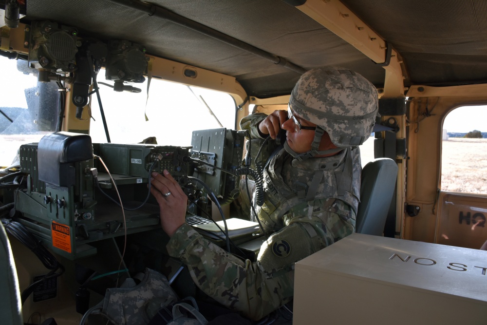
Soldiers in the field learn how to operate in a NAVWAR environment. (Photo: U.S. Army)
What NAVWAR Does. NAVWAR allows the Army to take deliberate defensive and offensive actions to assure U.S. forces PNT information through coordinated employment of space, cyberspace and electronic warfare operations. PNT data enables the Army to precisely move, shoot and communicate; extend its operational reach; control the tempo of operations; and perform mission command, all without adversarial interruption.
NAVWAR capabilities include electronic protection which includes systems and capabilities required to defend platforms and systems against electronic acts in the GNSS electromagnetic spectrum.
The Army has more than 250,000 GPS-dependent systems.
Additionally NAVWAR provides electronic support to sensors and software used to search for, intercept, identify, locate or localize, and report sources of intentional and unintentional radiated GNSS electromagnetic interference for mitigation and planning future operations.
NAVWAR can also provide electronic attack with capabilities to seize and sustain the initiative by actively degrading or denying the GNSS electromagnetic spectrum to adversaries in multi-domain operations.
The Army is dependent on the use of this data with a typical brigade combat team depending on more than 28 different systems and 600 total systems that leverage PNT. The Army has more than 250,000 GPS-dependent systems.
“As the Army goes forward in multi-domain operations, what we see the battlefield becoming is a contested environment,” Dalton said. “What that means is there are adversaries that will look to challenge the United States across all operational phases and domains. These enemies will have the capability to disrupt signals, like GPS, that can impact a wide range of military and civilian activities.
New NAVWAR Concept. SMDC is developing a TRADOC-sponsored Army NAVWAR concept that will be used to establish a baseline for how the Army will execute the NAVWAR fight.
The Army is highly dependent on the use of GPS-delivered PNT data. NAVWAR prevents the use of GPS by hostile forces while ensuring unimpeded use for U.S. forces and allies.
“In the command’s advocacy role we work with the joint and Army communities to examine what the Army needs to be able to accomplish the mission through navigational warfare,” Dalton said. “We work with a community of interest to determine the requirements that will build capability and reduce shortfalls in this mission area.
“This includes activities like updating doctrine, our organizational structure, ability to train the force, and ultimately determine if we need additional equipment, or holistic solutions to protect capabilities and disrupt the enemy on the navigation warfare side,” he added.
Training and Research. SMDC, in conjunction with U.S. Forces Command and the Joint Navigation Warfare Center, supports training events under degraded GPS conditions. The goal is to enable tactical formations to develop and train tactics, techniques and procedures that enable Army formations to work.
“We help develop and focus the capability requirements for the Army,” Dalton said. “But we are integrating with a larger community, led by the Assured Positioning, Navigation and Timing Cross-Functional Team that is focused on modernizing the Army in this mission area.”
SMDC is the Army lead for institutional unity of effort on NAVWAR with several research, development, test and evaluation and capability integration efforts working on the issue independent of one another.
“It is definitely an exciting time for NAVWAR,” Dalton said. “The Army, services and Department of Defense, as a whole, have started to embrace the importance of this mission area and understand the competitive advantage the U.S. and our partners can gain while denying the adversary the ability to conduct operations with respect to navigational warfare.”
The U.S. Air Force will load a new signal feature, designed to make spoofing detectable, aboard a satellite that will broadcast it from space as a security overlay for the GPS L1C signal, but not until 2022 at the earliest.
The Chips Message Robust Authentication (Chimera) is now in testing under the auspices of the Air Force Research Laboratory (AFRL), getting ready to fly on the Navigation Technology Satellite 3 (NTS-3), which will trial a number of new PNT techniques and technologies.
Chimera inserts encrypted digital signatures and watermarks within the L1C signal. A GPS receiver with the requisite additional capability for this purpose can then detect whether the signal is real or fake and also authenticate the location of a GPS receiver that is remotely located.
This key feature could provide a defense against hacking by blocking access from anyone unable to prove they are at an anticipated or licensed site. Hacking, of course, is a growing threat to all sorts of infrastructure: financial, security, utility grid and more.
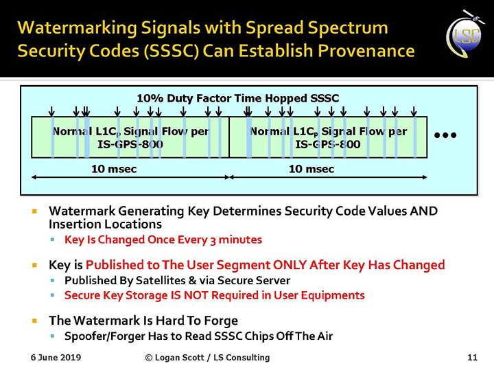
Presentation slide from PNT Advisory Board briefing by Logan Scott.
Consultant Logan Scott first proposed the Chimera technology in 2003, when he affirmed that “Some of the spoofing detection measures in wide use offer a false sense of security. Authenticatable signal architectures are needed.” In June, he made a presentation to the PNT Advisory Board: “The Role of Civil Signal Authentication in Trustable Systems.” The two slides accompanying this article appeared in that presentation.
“Chimera represents a fundamental paradigm shift in PVT security paradigms,” Scott related in a subsequent conversation. “Trust takes time and memory on a personal level and, in this case, in GNSS signals, too.
“You don’t trust somebody as soon as you meet them. Over a period of time, you get to know them. If you can’t remember anything, you can’t develop trust either.”
“In the GNSS world, there are a lot of applications where you don’t need output in real time,” Scott said. “For example, to align an inertial. The inertial provides the real-time aspect. You don’t want to send anything to the IMU that is factually incorrect. When building to aid inertial, I can afford to have a delay from real time as long as I tell it where it was 10 seconds ago. The power of that is, if I don’t have to give real-time output, I can ponder and think about things.
“If a spoofer attacks, there’s an evolution that happens there. If I, as the receiver, can see the developing scenario, and how it starts to look at little screwy, I can stop and not send anything to the IMU that might corrupt it.”
How It Works. The core concept of Chimera involves the satellites sending encrypted watermarks, encoded into the signal by the satellite. After a slight delay, the satellite sends the key used to generate those encrypted watermarks. Once a key is sent, the system changes the key.
Since the receiver has already recorded the signal with its watermarks before the key is sent, spoofers cannot know the correct key ahead of time, in time to insert correct watermarks of their own. This means that any spoofed signals can be easily spotted: either the subsequent key won’t match up with the spoofed watermarks, or there will be no watermarks at all.
“Another reason it’s hard for someone to generate these watermarks on their own is because the signal is buried below the noise,” added Scott. “The watermarks are hidden.”
A number of different time delays between signal and key are possible within this concept and within the general set-up of GPS. Scott and the AFRL have, for various practical reasons, provisionally settled on a 6-second delay on the fast watermark channel and a 3-minute delay for the slow watermark channel.
The signal enhancement could be incorporated into the Wide Area Augmentation System (WAAS). This has yet to be fully determined, but this route would lead to a faster implementation of Chimera. Scott thinks that going the WAAS route could bring Chimera capability into action within two years.
The AFRL, however, is looking at a much longer timeline. The NTS-3 satellite, where it first intends to test Chimera, will not launch until 2022 — three years hence. And that’s only a test, not an enactment or a system-wide implementation.
Slide: Logan Scott
Verification. One key benefit for commercial entities, particularly those in financial infrastructure and other systems that increasingly fall victim to hacking, is that Chimera gives them the ability to verify customers’ or partners’ locations before granting any kind of access. The customer’s or other erstwhile user’s GPS receiver would record the full signal, including the watermarks, and transmit that data to the company, entity or data center needing location verification, before the keys are published. Each combination of watermarks and signals is unique to the place where it was recorded, thus it is possible to tell whether the user is actually where they say they are, or in an authorized or pre-identified location before granting access or accepting further input (such as commands).
Scott claims that Chimera affords a 99.9% probability of detecting spoofers. “I have a 99.9% chance of detecting that the watermark is not there, because they don’t know how to generate it. This is based on how you’re processing the signal. It’s designed to be very flexible in how the receiver uses the signal.”
Just One Problem. Receiver manufacturers will have to develop new Chimera-capable receivers, and customers will have to buy them. An additional cost for the added processing, above and beyond that required for normal GPS operation, is unavoidable.
And a Hiccup. Chimera, while an acronym, is as a name perhaps not a totally felicitous choice. In Greek mythology, the chimera is a fire-breathing female monster with a lion’s head, a goat’s body, and a serpent’s tail. These historic ancestors have evolved into the word’s more current use: a thing that is hoped or wished for but that is in fact illusory or impossible to achieve.
AFRL Wants Your Opinion. The Air Force Research Laboratory seeks feedback from the PNT community on the Chimera enhancement for the L1C signal. The specification is here. And, you can download a comment form
SiTime Corp. has unveiled its Endura micro-electro-mechanical system (MEMS) timing solutions for aerospace and defense applications including precision GNSS, as well as field and satellite communications, avionics and space.
The Endura products are engineered to provide high performance in harsh conditions — severe shock, vibration and extreme temperature — that are routinely experienced in these applications.
SiTime offers customers 5 million possible part numbers that can be created from 17 programmable products.
“When exposed to high levels of shock, vibration, and extreme temperatures, legacy timing components have been prone to failure, degrading system performance and reliability,” said Piyush Sevalia, executive vice president of marketing. “To solve these problems, SiTime created an oscillator system of silicon MEMS, analog circuits, compensation algorithms, and advanced packaging, which is designed to outperform any other available timing solution in harsh environments.
“For example, Endura precision TCXOs deliver 4 parts per trillion per g (ppt/g) of acceleration sensitivity, which is 50 times better than legacy quartz-based solutions. With such performance, we believe that Endura will transform the oscillator landscape in aerospace and defense.”
Highlights of the company’s solutions include:
4 parts per trillion per g force of acceleration (50 times better than quartz)
Supports –55 degreesCelsius and +125 degrees Celsius operation
Key timing specifications conform to MIL-PRF-55310
Five million possible part numbers
Endura Super-TCXOs (temperature compensated oscillators) for use in high-speed communications and GNSS applications include:
SiT5146/SiT5147 – 1 to 220 MHz, ±0.5 to ±2.5 ppm, -40 degrees Celsius to +105 degrees Celsius
SiT5346/SiT5347 – 1 to 220 MHz, precision ±0.1 to ±0.25 ppm, -40 degrees Celsius to +105 degrees Celsius
SiT5348/SiT5349 – 1 to 220 MHz, ultra-precision ±0.05 ppm
SiTime’s portfolio of commercial off-the-shelf (COTS) Endura products spans six oscillator types and 17 products. All devices offer programmable options such as frequency, operating voltage and stability.
In addition, some devices offer specialized programmable features such as spread spectrum, pull-range, and differential output type.
Endura products are available with up to two grades of acceleration sensitivity, as low as 4 ppt/g (typical). This breadth of products provides customers with a large selection and the ability to configure each device for their application requirements.
Endura products are also designed for continuity of supply for long-life programs.
What is the biggest safety challenge for autonomous vehicles?
John Fisher. (Photo: Orolia)
“Sharing the road with human drivers. Optimized safe driving algorithms are compromised to mesh with the human’s natural level of risk taking. But this reduces safety, delaying acceptance — a real conundrum. Now, if we could just eliminate the humans…” John Fischer
Orolia
Julian Thomas
“When AI systems can deal with 99.9% of situations, the challenge will be keeping the passenger engaged to take over quickly when the 0.1% happens. Imagine a truck in front with a load coming loose. Which one would you trust?” Julian Thomas
Racelogic
Members of the EAB
Tony Agresta Nearmap
Miguel Amor Hexagon Positioning Intelligence
Thibault Bonnevie SBG Systems
Alison Brown NAVSYS Corporation
Ismael Colomina GeoNumerics
Clem Driscoll C.J. Driscoll & Associates
John Fischer Orolia
Ellen Hall Spirent Federal Systems
Jules McNeff Overlook Systems Technologies, Inc.
Terry Moore University of Nottingham
Bradford W. Parkinson Stanford Center for Position, Navigation and Time
Our cover story this issue is all about autonomous vehicles. Retirees — not usually considered early adopters of technology — are trusting autonomous vehicles to ferry them from point to point using the technology our industry can offer.
We have also used a lot of magazine space to discuss unmanned aerial vehicles, or drones, and shown how they are taking on a lot of tasks formerly done by manned pilots or workers, such as aerial mapping or factory inspections.
So is the idea of an autonomous plane such a stretch?
At June’s Paris Air Show, Christian Scherer, chief commercial officer for Airbus, told the Associated Press that his company already has the technology to fly passenger planes without pilots.
Scherer also said in the AP interview that Airbus hopes to be selling hybrid or electric passenger jets by around 2035.
Airbus already has “the technology for autonomous flying.”
But having the tech is one thing. Winning over regulators and potential travelers is quite another.
“When can we introduce it in large commercial aircraft? That is a matter we are discussing with regulators and customers, but technology-wise, we don’t see a hurdle,” Scherer said.
In fact, in a new study, seven out of 10 people say they would be willing to travel in an unpiloted plane at some point in their lifetime. The survey was conducted by U.S. software firm Ansys, which is working to provide digital replicas of how planes and cars react in different situations.
Passengers would be more willing to embrace automation if firms could show that a computer would react in the best and quickest way if anything unexpected happens.
But are we there yet? Michael Wiggins, the chairman of the aeronautical science department at Embry-Riddle Aeronautical University in Florida, addressed the autonomous-flight adoption question for the New York Times.
“From what I see, could it happen in the distant future? I think it probably could. Will it happen in the near future? I don’t think so,” Wiggins said. “Right now, any progress toward that area should be done very slowly, very measured and only after a bunch of research with results that suggest we should do that.”
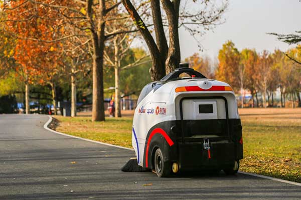
The sweeper Woxiaobai has been in service for a year. (Photo: Unicore)
Fall is a beautiful time of year. But when the leaves drop, it means a lot of sweeping for most of us. Not so for the 200 campuses and parks in China using IdriverPlus’ WO series of unmanned sweepers.
High-precision GNSS positioning plays an important role in making the autonomous units possible, providing real-time high-precision position, speed and time information.
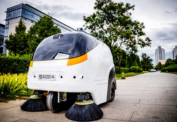
The sweeper in Beijing’s Haidian Park. (Photo: Unicore)
Unicore’s high-precision GNSS technology and their products’ high reliability have enabled IdriverPlus’ unmanned sweepers and logistics vehicles — China’s first mass-produced products in intelligent driving. In January, IdriverPlus received the green light to test self-driving cars in Beijing.
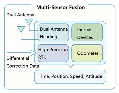
Diagram: Unicore
Sweepers and logistics vehicles are not only used in open-sky areas, but also in complex environments shadowed by buildings or trees or experience multipath. These areas include school campuses, factory and science parks, and community squares.
Complex environments result in different GNSS availability, reliability and convergence. In autonomous driving, the inputs the vehicle receives from GNSS and other sensors must be accurate and reliable.
A customer removes her express package from the Wobida logistics vehicle. (Photo: Unicore)
The UM482 module used by the IdriverPlus is characterized by dual antennas, compact dimensions, high performance and low cost, providing anti-jamming performance.
Integrated with on-board MEMS and Unicore’s U-Fusion combination technology, the UM482 can effectively solve the disruption of positioning results caused by the loss of satellite signal, and further optimize the continuity and reliability of positioning and heading outputs in complex environments such as city canyons, buildings and tunnels.
Two companies have integrated GPS/PNT tech into a growing autonomous vehicle market: driverless shuttles for retirement communities. Powering the service, a cloud-based GNSS corrections system delivers centimeter-level accuracy without deploying and maintaining a GNSS network. This leading-edge application targets autonomy at scale and enables high-precision positioning for mass-market automotive and autonomous vehicle applications.
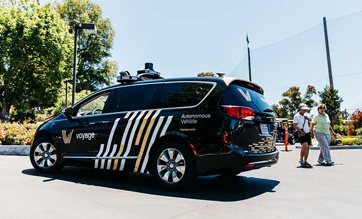
Photo: Voyage
For many seniors, retirement communities offer the best of both worlds: the freedom to live in their own homes and access to immediate assistance when they need it.
Driverless cars are an option several retirement communities have embraced to better serve residents who no longer have the ability or desire to drive, but want to retain the ability to come and go as they please.
“Autonomous vehicles are a great fit for any community where the environment is well-understood, less complex than dense urban areas, and the transportation demand is high,” said Justin Erlich, vice president of strategy, policy and legal for Palo Alto, California-based Voyage, a company that employs existing technology to develop fleets of autonomous vehicles. “Retirement communities satisfy all of these characteristics.”
Serving Seniors
Voyage deployed driverless shuttles to serve 130,000 retirees at The Villages, a massive retirement community encompassing more than 50 square miles in Sumter County, Florida.
“The community’s residents enjoy an extremely active lifestyle, but often face challenges getting around,” Erlich said. “Autonomous vehicles are perfectly suited to meet this demand.”
The six vehicles in the fleet stay within the confines of the retirement community, where all roads have been precisely mapped, speed limits are lower and traffic patterns are more clearly defined than in a typical city. The vehicles travel over a network of roads that span 750 miles.
THE VILLAGES
Location: Sumter County, Florida Area: 50 square miles Road span: 750 miles Number of retiree residents: More than 130,000 Number of Voyage autonomous vehicles: 6
To request one of Voyage’s autonomous vehicles, a resident can summon the shuttle on-demand with a smartphone. Voyage is working with residents on the possibility of using other shuttle-request options, including text messages, phone calls and well-marked pickup zones in crowded downtown areas, Erlich said.
All passengers ride with Voyage safety drivers in the front seat. The drivers take note of any “events” during rides so Voyage can investigate how to improve the riding experience.
Photo: Voyage
Eventually, residents will be the only passengers in the vehicles. If they need assistance during a ride, they will be able to communicate with remotely located Voyage employees, Erlich said.
Testing and rolling out fleets of driverless vehicles in private communities like The Villages allows Voyage to develop and perfect the autonomous vehicle technology it uses. As a result, the company can deliver the service to new clients in mere months.
Voyage, which has been working on its autonomous technology for more than two years, uses daily customer feedback to constantly adjust to its technologies to better serve riders.
“Feedback collected during test drives is one of the biggest factors in shaping our technology roadmap,” Erlich said. “Driving data — collected across all sensors and traffic scenarios — is automatically processed each night, highlighting interesting ‘events’ for our engineering team to analyze and review.”
During Voyage’s beta test process at The Villages, residents applied to be part of the company’s Pioneer Program for early access to the autonomous vehicles and the ability to offer feedback early on. Riders who test the service complete scorecards after each trip to help improve the experience for all riders.
Europe Takes the Lead
(Tire photo: iStock.com / TANAPHONG)
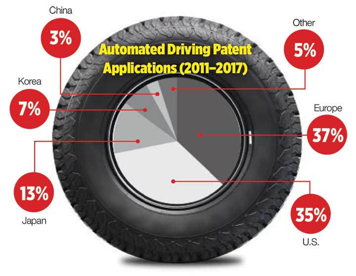
Autonomous vehicle technology is taking off in Europe, shows a study published by the European Patent Office and conducted with the European Council for Automotive Research & Development. From 2011 to 2017, European patent applications related to automated driving increased 20 times faster than other technologies in recent years. The “Patents and self-driving vehicles” study reveals automated driving patent applications at the European Patent Office rose 330%, compared with 16% for all technologies during the same time.
“As one of the only self-driving car companies that are picking up actual passengers as a part of our Pioneer Program, we believe we can learn a lot from the feedback we hear from our initial Pioneer riders as we try to make this the best service for The Villages,” said Oliver Cameron, co-founder and CEO of Voyage. “We are excited to see so much interest from other residents to become a part of this program.”
When developing autonomous technology, safety is Voyage’s top priority, Erlich said. Every change to the hardware and software used undergoes a multi-stage validation process. Company engineers perform “on-desk” tests of every change using unit tests, functional tests and a driving simulation environment. Then, an operations team runs suites of real-world traffic and validation tests in a completely controlled environment at a closed-course testing facility in San Jose, California
“Voyage makes extensive use of simulation testing and closed-course validation before any of our vehicles are driven in our partner communities,” Erlich said. “All changes must pass these closed-course tests before making their way onto the roads of our partner communities.”
Vehicle design also ensures riders stay safe. “Our fleet vehicles have been designed with multiple levels of safety redundancies for braking, steering and power, and leverage an advanced diagnostics system to automatically detect anomalies and safely stop the vehicle,” he explained. “In addition, we have developed a remote teleoperations solution that allows the vehicle to request additional help when a driver is not physically in the vehicle.”
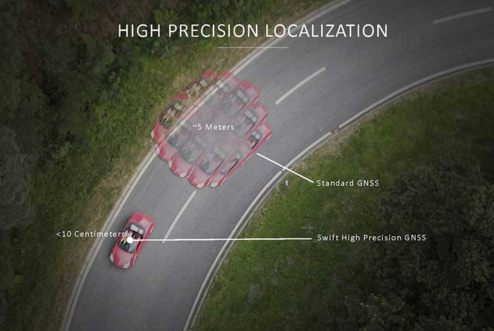
Skylark provides high-precision localization. (Image: Swift Navigation)
Making Autonomous Work
When building an autonomous system, localization — knowing exactly where you are in the world — is critical. Erlich said it’s often difficult to estimate your position within an accuracy of several feet when using more traditional GPS solutions.
“For autonomous driving, you need to be able to estimate within several centimeters,” he added.
Voyage uses Swift Navigation’s GNSS receivers and Skylark network as one of the primary inputs into its localization solution.
Swift Navigation is a San Francisco-based tech firm that develops GPS technology to power autonomous vehicles. It is working to extend the Skylark network across the contiguous United States, and then plans to expand globally.
“Coupled with high-definition maps, odometry sensors and other inputs, we’ve been able to use Swift Navigation’s differential GPS solution to achieve the localization results we needed to deliver a true autonomous driving service,” Erlich said.
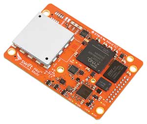
Voyage’s autonomous vehicles are equipped with a suite of sensors on their roof racks that includes the Swift Navigation Piksi Multi GNSS receiver, lidar devices, cameras, radar and an inertial measurement unit. They create and constantly update a 3D map of the vehicle’s surroundings.
Swift Navigation’s Duro is one of two GNSS receivers Voyage uses for its autonomous vehicles. (Photo: Swift Navigation)
A computer in the trunk integrates all sensor signals and uses the vehicle’s Controller Area Network (CAN) bus to operate steering, braking and other functions.
Skylark, Swift Navigation’s cloud-based GNSS corrections service, provides Voyage’s autonomous vehicles with precise positioning to eliminate the complexity of deploying and maintaining GNSS networks.
Skylark offers a plug-and-play experience that delivers convergence times measured in seconds. Its positioning algorithms provide a continuous data stream to individual devices from the cloud. This data stream allows for quick positioning and high reliability and availability.
The correction service enables receivers to connect to a constantly adapting, cloud-based model to obtain GNSS observations. Dependence on base stations in each area of deployment is eliminated, increasing the geographic area in which they can travel. Skylark works seamlessly with both of Swift Navigation’s GNSS receivers — Piksi Multi and Duro.
In addition to Piksi Multi and Duro, Voyage uses third-party receivers and microprocessors that benefit from the lane-level positioning Skylark delivers.
Equipment Specs
Photo: Swift Navigation
GNSS receiver one. Swift Navigation — Piksi Multi
• Dual-frequency and multi-constellation
• Up to 20-Hz solution rates
• Raw data outputs from on-board MEMS IMU GNSS receiver two. Swift Navigation — Duro
• IP67 rated
• Centimeter-level positioning
• Raw data outputs from on-board MEMS IMU Lidar devices. Velodyne — VLS-128
• 128 channels
• Up to 300-meter range
• Up to 360-degree surround view Cameras. iDS — Global-Shutter units Proximity sensors. Chrysler OEM Inertial measurement unit. Xsens — MTi-300
• 375-Hz bandwith for accelerometers
• 415-Hz bandwith for gyroscopes Antenna. Swift Navigation — Mini-survey for the Duro RTK unit
• 1 L1/L2 GPS/GLONASS/BeiDou mini-survey
The Swift product suite delivers centimeter-level localization —important to riders who may have mobility issues that require vehicles with smooth starts and stops.
Skylark was built specifically to deliver the speed, security, precision and reliability demanded by automotive manufacturers with autonomous and safety applications architected to support ASIL-rated (Automotive Safety Integrity Level) systems.
Because Skylark is a network, it is fault tolerant. In the unlikely event an individual cloud reference station goes offline, Skylark’s positioning algorithms will continue to provide a continuous stream of corrections.
Once connected, Skylark creates a precise and constantly adapting model of the atmosphere and related errors affecting GNSS. Connected users simply turn on their devices to get the precise positioning data they need.
Safety Drivers
As drivers get older, their mental and physical health can affect their ability to operate vehicles safely. Vision and hearing loss keep many older drivers off the road. Fear of driving at night or in the rain also can be a problem for older drivers. According to the Centers for Disease Control and Prevention (CDC), about 7,400 adults over the age of 65 died as a result of car accidents in 2016. That same year, more than 290,000 of adults over the age of 65 were treated in emergency departments for injuries sustained in motor vehicle accidents.
Residents at The Villages who have used the autonomous vehicles report positive feedback, Erlich said. They consider the service a major improvement to their day-to-day activities because it’s convenient. Plus, they prefer the ability to be more carefree during happy hour, fewer hassles with traffic and parking, and lack of interactions with poor drivers.
Being on the cutting-edge of a generational technology also is a positive for many residents, Erlich said. “Autonomous vehicles create a clear path to safer, more accessible, and reliable transportation for everyone. From a safety perspective, autonomous vehicles have the potential to significantly reduce the more than 37,000 deaths attributed each year to driving. From a lifestyle perspective, there are also huge opportunities: from reclaiming daily commute time, to providing a reliable means of transportation to people with mobility challenges.”
Positioning Intelligence Key to Autonomous
Hexagon’s Positioning Intelligence (PI) division is an integral partner in many autonomous vehicle development projects, providing technologies such as SPAN (GNSS+INS technology), TerraStar-X corrections, and Automated Research and Development Platforms from its brands including NovAtel, VERIPOS and AutonomouStuff.
NovAtel hardware and software products, along with engineering support, address the need for accurate, reliable and robust GNSS positioning. TerraStar-X correction services deliver worldwide coverage and assured positioning with continuous availability, and provide the accuracy and rapid convergence needed to achieve lane-level precision for safe autonomous operation.
For developers of autonomous consumer transportation, integrated research and development automotive platforms from AutonomouStuff accelerate time to market.
Making It Safe. For large-scale automotive production, safety is the main focus. The Hexagon PI software positioning engine and TerraStar-X technology are being developed to ASIL-B (Automotive Safety Integrity Level B) standards to provide precise positioning for lane-level performance in autonomous applications.
Image: Trimble
Road Corrections
Incorporating precise and consistent absolute location information is an essential component of enabling advanced driver assistance (ADAS) and autonomous driving (AD) technology for vehicles.
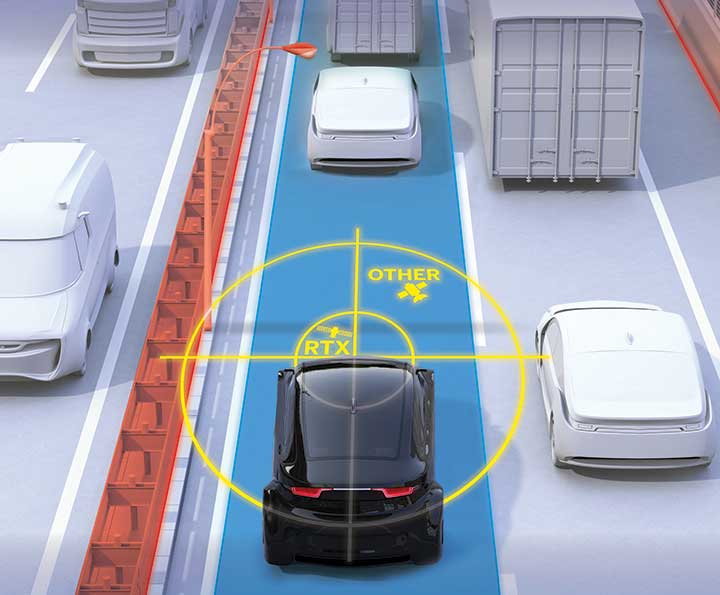
To help meet this need, Trimble recently released Trimble RTX Auto. The Trimble RTX Auto correction service provides a precise point position (PPP) solution that can be used to correct the position of any auto grade GNSS chipset. RTX Auto works in parallel with other on-vehicle sensors to deliver a positioning solution that satisfies ADAS and AD requirements.
Absolute position contributes to many features:
Lane centering. Systems designed to keep a car centered in a lane, relieving the driver of the task of steering, is often achieved with cameras and absolute position data. Absolute position can be used when lines disappear, or weather prevents them from being seen.
Map aiding. a combination of precise map and location data helps to navigate junctions, lane changes, roundabouts or intersections where lane information is essential to safe driving.
Prediction of future road structure. Both allow a vehicle to begin slowing in advance of a bend in the road and to avoid harsh braking that would happen if the system only relied on short range sensors.
Adhering to the speed limit. This helps drivers anticipate changes in speed limits when a downpour prevents cameras from seeing the speed limit signs or when they might be obscured by natural surroundings or another vehicle.
RTX Auto is both Automotive Safety Integrity Level (ASIL) and Automotive Software Process Improvement and Capability Determination (ASPICE) certified. These certifications validate that Trimble RTX Auto meets functional safety requirements for ADAS and autonomous applications in the auto industry.
Super Cruising. Trimble is on the road today providing RTX-based absolute positioning within General Motors’ Super Cruise driver assistance feature, a hands-free driving system for the freeway. For more information on Super Cruise, visit www.cadillac.com/world-of-cadillac/innovation/super-cruise.