TDK’s booth at the Consumer Electronics Show (CES) is in South Hall 3, Booth #30306, and offers a look at sensors, passive components and more from TDK and its group companies. (Photo: TDK)
TDK Corporation has launched its InvenSense Coursa Drive software, an inertial-aided positioning solution for autonomous vehicle platform developers.
A high-performance extension of the InvenSense Positioning Library (IPL) that has provided sensor-aided positioning to more than 50 million devices worldwide, Coursa Drive enhances inertial-only vehicle positioning to <0.2 percent of distance traveled. These precise levels of accuracy are critical to maintaining decimeter lane-level vehicle positioning in challenging GNSS/perception system environments.
Coursa Drive’s inertial navigation system (INS) calibrates using absolute position inputs from either high-accuracy GNSS receivers or from perception-based systems (camera, radar, lidar) with high-definition (HD) maps.
In real time, Coursa Drive provides high-rate, 100 Hz delta positions and orientation to the autonomous vehicle (AV) system, complementing the lower-rate position references from GNSS and perception systems.
For improved system fault-tolerance, Coursa Drive can provide decimeter position precision for short periods when the GNSS or perception systems are uncertain or unavailable.
For non-real-time applications such as HD map creation and maintenance, Coursa Drive’s offline mode reprocesses INS data at two to three times higher accuracy than real-time mode, providing HD map companies alternative position references to verify HD map accuracy, even without GNSS, for up to 60 seconds.
“Coursa Drive delivers vehicle dead reckoning accuracy equivalent to high-end systems costing thousands of dollars,” said Mike Housholder, senior director of the TDK InvenSense Location Software and Services Business. “Our cost-effective software solution will help AV platform and Tier 1 vehicle manufacturers scale beyond prototype vehicles to high-volume mass production.”
Coursa Drive provides autonomous vehicle platform developers with maximum flexibility for system integration. The solution is platform agnostic and can operate on Cortex-M4F-class microcontrollers, or higher, and supports most dual-frequency GNSS receivers. The Coursa Drive API specifications are available upon request.
Coursa Drive is thoroughly tested and characterized using the InvenSense line of automotive-grade IMUs, including the IAM-20680 and IAM-20680HP, as well as several industrial grade IMUs. Coursa Drive is available now for select early partners and customers.
TDK and its group companies offering a comprehensive portfolio of sensors, electronic components and solutions for mobile, wearables, AR/VR, automotive, IoT and industrial applications will be at CES 2019, showcasing the Coursa Drive solution, along with additional innovative sensor solutions, in Booth #30306, Las Vegas Convention Center, South Hall 3, Jan. 8-11, Las Vegas.
Main applications
Level 2 to Level 5 advanced driver-assistance systems (ADAS)
Robotaxis
Trucking
Precision agriculture
Key features
World’s first high-precision inertial-aided positioning software for AVs
Inertial-only decimeter precise positions provided during short GNSS or perception system outages/uncertainties
High-rate, 100 Hz position and orientation updates supplied to the AV system
GNSS-agnostic software solution offers flexible integration for full-stack AV solution providers
Unique offline mode further enhances accuracy by two to three times for HD map building and maintenance applications.
Due to the extended impasse between U.S. Congressional leaders and the White House that has created a partial U.S. government shutdown, the Institute of Navigation (ION) has decided to postpone the Cognizant Autonomous Systems for Safety Critical Applications (CASSCA) Conference, originally scheduled to take place Jan. 28-29 at the Hyatt Regency Reston in Reston, Virginia.
The government shutdown has impacted CASSCA speakers and attendees and brought uncertainty about the number of government officials working in autonomous systems who are currently furloughed, making this decision inevitable.
The CASSCA Conference has been rescheduled for Sept. 16-17 in Miami, in parallel with ION GNSS+.
“The ION is committed to this strong and dynamic technical program and is confident this venue will provide maximum exposure and networking opportunities for the highly esteemed invited speakers and conference attendees,” the institute said in a press release. A revised program is available.
The ION’s International Technical Meeting (ITM) and Precise Time and Time Interval (PTTI) Systems and Applications meeting will proceed as scheduled, Jan.28-31, at the Hyatt Regency Reston, Reston, Virginia. ITM/PTTI 2019 is heavily supported by academia, industry and the U.S. Department of Defense; ITM/PTTI pre-registration levels are currently trending ahead of 2018 and the technical program is strong.
Hagai Zyss, CEO of Autotalks. (Photo: Daniel Danilov)
Autotalks’ second-generation chipsets have been selected by Harman International to provide the vehicle-to-everything (V2X) chipset for the Harman telematics platform. The platform will be showcased at the Consumer Electronics Show, taking place Jan. 8-11 in Las Vegas.
With V2X, all vehicles share location, speed and trajectory, giving drivers warnings of on-road dangers. Autotalks’ second-generation chipsets are mass-market ready and support both DSRC and C-V2X direct communications (PC5 protocol).
Harman is a wholly-owned subsidiary of Samsung Electronics Co. Ltd., focused on connected technologies for automotive, consumer and enterprise markets.
Harman will showcase a connectivity display of its telematics platform with C-V2X capabilities. The live demonstration will show a vehicle communicating with a motorcycle using C-V2X direct communications (the Autotalks chipset is used in both).
Harman’s solution consists of a modular telematics control unit (TEC) accommodating a cellular network access device (NAD) beside Autotalks’ second-generation chipset providing C-V2X capabilities. Autotalks C-V2X capabilities consist of a 3GPP compliant PC5 modem, with dual antenna and diversity for both transmission and reception, as well as an optimized closed-loop remote antenna solution for the highest radio performance.
“Autotalks is proud to work with Harman on their TCU with our secure and deployment-ready C-V2X solution,” said Hagai Zyss, CEO of Autotalks. “We are excited to have our chipset inside Harman’s telematics platform and to demonstrate the flexibility and maturity of our global V2X solution which has been chosen for series production by leading automakers.”
“Together with Harman, we will achieve deployment readiness before the mass-commercialization of C-V2X in China and elsewhere,” Zyss said.
“We are pleased to showcase Autotalks’ C-V2X capabilities in our Telematics platform at CES 2019,” said Mike Peters, president, Connected Car Division at Harman. “The Autotalks chipset provides us with the flexibility, security and performance needed in today’s worldwide market for telematics and V2X.”
Autotalks’ V2X chipset is now available for customer and partner demonstrations.
Septentrio, a high-precision GNSS company, and Sapcorda, a specialist in GNSS correction services, will conduct a live demonstration of a safe, high-accuracy positioning and correction solution for automated driving.
“We are running the demonstration during the course of this week just south of Las Vegas city center,” Neil Vacans told GPS World. Vacans is Septentrio’s vice president of global Sales. The demonstration is taking place in Las Vegas during the Consumer Electronics Show, being held Jan. 8-11.
Sapcorda and Septentrio have put together a solution that is ready for demonstration in Europe and North America.
The companies have combined their respective technologies to deliver the benefits of SSR (space state representation) technology seamlessly to OEM automakers and Tier 1 integrators. These benefits include decimeter-accuracy within seconds, anywhere over an entire continent, to support autonomy levels from lane keeping to full autonomy in a totally homogeneous coverage, the companies said.
The GNSS augmentation service is scalable through simple broadcast corrections, and safety-awareness is provided via Sapcorda’s integrity concept and Septentrio’s integrity monitoring engine.
In December 2018, Septentrio announced its mosaic compact multi-constellation GNSS receiver SiP (system-in-package) module, available in 2019. The Septentrio mosaic, a multi-band, multi-constellation receiver in a low-power surface-mount module with a wide array of interfaces, is designed for mass-market applications like robotics and autonomous systems. The mosaic module integrates the latest GNSS and RF ASIC technology, as well as the robust positioning engine from Septentrio.
All Septentrio GNSS receivers and modules feature AIM+ technology, an advanced on-board interference mitigation commercially available. Septentrio GNSS receivers can suppress the widest variety of interferers, from simple continuous narrowband signals to the most complex wideband and pulsed jammers.
“We are excited to be able to provide live demonstrations of Sapcorda’s safe and precise correction service especially designed for autonomous driving,” said Jan Van Hees, business development director at Septentrio. “Sapcorda provides a unique high-precision GNSS correction service designed for fast, homogeneous accuracy at continental coverage, thus ideal for autonomous and mass market applications.”
“Septentrio specializes in high-precision and high reliability GNSS positioning for a variety of industrial and commercial markets,” said Goran Jedrejčić, business development manager at Sapcorda. “They have developed a range of technologies, including unique jamming robustness and integrity positioning to support safety-sensitive applications in various challenging environments. Combining this with our safety-centered correction service, it is a unique solution for developers of autonomous driving systems.”
“With fast and efficient implementation of Sapcorda SSR-based correction service into Septentrio’s GNSS-platform, we were able to demonstrate the efficiency of the technology for automotive use in a robust & highly efficient way,” confirmed Jedrejčić. “Septentrio offers a unique blend of GNSS-based technologies and is an ideal partner for both traditional and new markets, with growing demand for high-precision positioning.”
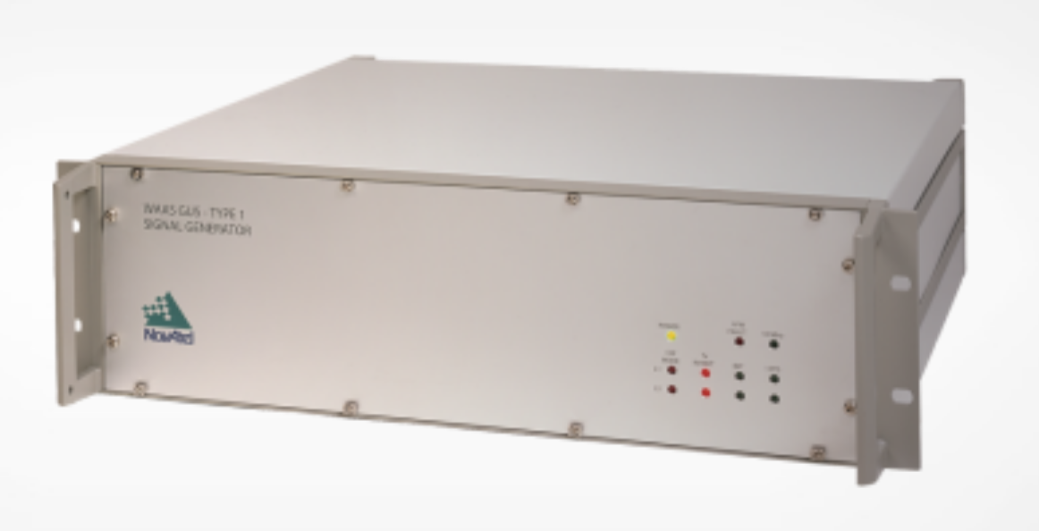
NovAtel has been awarded a contract from the United States Federal Aviation Administration (FAA) to design, produce and deliver 40 next-generation Ground Uplink Station (GUS) Signal Generators to support the FAA’s safety-of-life WAAS navigation service. The service provides safety-critical infrastructure for the North American aviation navigation network.
GUS signal generator. (Photo: NovAtel)
The contract also includes ongoing engineering support services for NovAtel’s complete portfolio of satellite-based augmentation system (SBAS) products deployed by the FAA, including the WAAS G-III reference receiver platform.
The FAA has relied on NovAtel’s safety-critical SBAS technology for more than 20 years, starting with NovAtel’s first-generation WAAS reference receiver that was created in the 1990s.
Developed by the FAA, the WAAS network is a safety-critical navigation aid that allows aircraft to use GPS for all phases of flight. Every time an aircraft takes off or lands within the WAAS coverage area, NovAtel technology is generating and processing data that allows aviators to make precision approaches to any airport.
Since the program’s inception, NovAtel has provided the FAA with technology that delivers high-precision GPS receiver measurements and navigation information from WAAS Reference Stations and the GUS infrastructure.
Under this new contract, NovAtel will help modernize the WAAS network by upgrading and extending support for the network’s GUS infrastructure. The next-generation of GUS signal generators, which are designed specifically for SBAS ground uplink systems, will include independent L1 and L5 signal paths to precisely control the frequency and phase of L1 and L5 code and carrier for dual-frequency SBAS.
A GUS receiver system based on the WAAS G-III receiver platform will also be released along with the signal generator to complete the modernized GUS control loop.
“We have a long history with the FAA and have worked very closely with the WAAS program team to develop multiple-generations of SBAS infrastructure,” said Jonathan Auld, vice president of engineering and safety critical systems at NovAtel. “NovAtel remains committed to supporting the FAA and their safety of life WAAS service and we are excited to deliver this critical next-generation technology for SBAS modernization.”
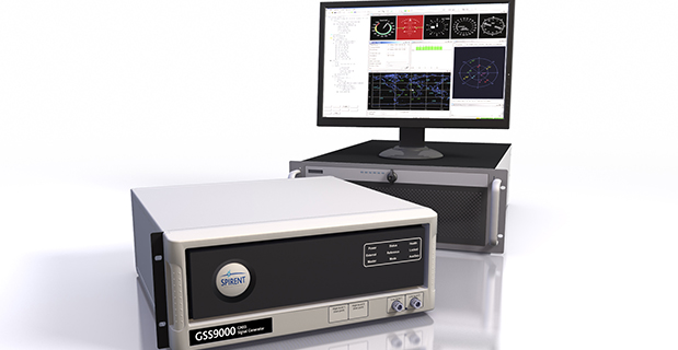
Spirent Federal Systems, provider of GPS/GNSS test equipment, has announced that its new M-code solution, SimMNSA, has been granted security approval by the Global Positioning System Directorate.
Spirent Federal is the first company to provide such a solution for simulating classified GPS signals, and is currently taking orders, the company said.
The GSS9000 simulator. (Photo: Spirent)
In 2017, Spirent Federal Systems partnered with Rockwell Collins to develop new software that will use the Modernized Navstar Security Algorithm (MNSA). This new approach of M-code simulation adds to Spirent Federal’s portfolio of classified signal simulation solutions, and will be available to authorized users of the GSS9000 series simulators.
“With the increased focus on M-code by the GPS Directorate, we are pleased that our team has paved the way in the development of SimMNSA,” said Ellen Hall, CEO of Spirent Federal Systems. “It was a great challenge to get to this point, but we are excited about what we have accomplished.”
The new test solution continues Spirent Federal Systems history of innovation and being first to market with M-code simulation software, the company said. Spirent’s GPS/GNSS solutions have supported numerous government, military and U.S. Department of Defense programs for more than 30 years.
RINEX 3.04 contains updates to support planned GLONASS CDMA signals, as well as new BeiDou III and QZSS II signals.
The International GNSS Service (IGS) and Radio Technical Commission Maritime Service, Special Committee -104 (RTCM SC-104) RINEX Working Group, announced the availability of RINEX 3.04.
RINEX 3.04 supports all publicly available signals from existing GNSS constellations: the U.S. GPS, Russia’s GLONASS, Europe’s Galileo, China’s BeiDou, Japan’s Quasi Zenith Satellite System (QZSS) and the Indian Regional Navigation Satellite System (IRNSS).
In addition to the new signals, the RINEX 3.04 text has been edited to improve the description of messages, fields and overall readability.
The RINEX 3.04 data standard documentation is available here:
Added new signals to the GLONASS (Table 5), QZSS II (Table 8) and BeiDou III (Table 9) signal tables and updated Table A23
Added section 9.12 to describe new signals from the GLONASS, QZSS II and BeiDou III constellations and to describe the differences between QZSS I and QZSS II
Updated Appendix Table A2 SYS/#/OBS TYPES to show new signal codes for: GLONASS, QZSS II and BeiDou III
Modified Appendix Table A5 TIME SYSTEM CORR section to clarify the GNSS time system and UTC difference fields
Added numerous small corrections and text improvements as listed in the RINEX 3.04 Revision History section.
Space Based Augmentation Systems (SBAS) – known in North America as the Federal Aviation Administration’s (FAA’s) Wide Area Augmentation System (WAAS) – have been fully operational in one form or another for several years. The FAA’s incremental improvements to integrity, accuracy and reliability in WAAS have brought the system to a point where we have precision en-route navigation for aircraft, and we can also land aircraft using WAAS signals at thousands of airports in the US and in Canada.
Why not Mexico, which also benefits from the same WAAS coverage? More on that later, as we piece together the many parts of the complex SBAS mosaic.
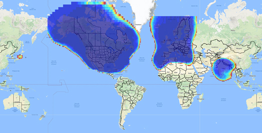
SBAS precision approach coverage, May 2016. Graphic: FAA Tech Center, Lockheed Martin, GMV
Europe benefits from high-accuracy en-route navigation, and there are also hundreds of operational approaches using the European Geostationary Navigation Overlay Service (EGNOS) SBAS.
In India, the GPS Aided Geo-Augmented Navigation (GAGAN) system provides accurate en-route navigation and approach capability. However, ionospheric disturbance may limit some aspects of performance.
Japan established the Multi-functional Satellite Augmentation System (MSAS) SBAS, and has benefited from improved en-route navigation, but it’s possible that the more limited geographic distribution of GPS ground reference stations has restricted improvements to approach capabilities.
But what happened to the International Civil Aviation Organization (ICAO) concept from 2007, supported by all the ‘aviation-going’ countries of the world, that SBAS would evolve and eventually multiple national systems would provide coverage around the rest of the world, maybe even by 2016?
Countries in Asia, South America, Africa and the continent of Australia all appear to have looked closely into establishing their own SBAS, but nothing seems to have come out of these investigations. Technical issues, cost, and political obstacles have all hindered global SBAS progress.
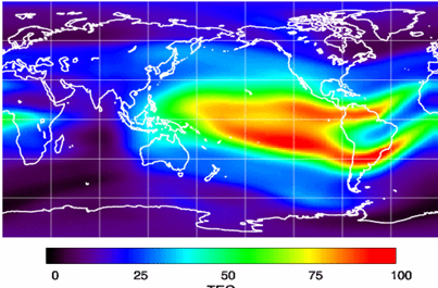
The ionospheric challenge. Graphic: GMV and Lockheed-Martin
Technical Issues. Ionospheric scintillation problems around the Equator seem to be at the root of most technical problems for SBAS. Getting to the required level of probable, bounded system error is hugely difficult. The iono disturbance ‘blob’ follows the sun around the Equator and wipes out any chance of satisfactory system performance when it passes over Equatorial countries.
As total electron count (TEC) increases, the ionospheric grid, which most SBAS use to predict ionospheric variation across their geographic area between fixed reference stations, well, it just doesn’t work anymore.
Cost. The capital cost of building a satellite-based augmentation system and the on-going cost of maintaining a bunch of geographically distributed reference sites, building and launching GEO satellites or renting transponders on someone else’s orbiting asset, establishing, operating and maintaining redundant uplink stations, redundant terrestrial data links, and setting up control systems that collect and create the SBAS uplink message — it all adds up. Millions and maybe even billions of dollars or equivalent, in total, have been spent by those select countries who could afford their own SBAS. Others named above have lesser financial resources upon which to draw.
Political Obstacles. One of the trickiest issues is sovereignty: the need for a country to control its own navigation and landing system. This has likely been the source of most resistance to more SBAS systems being set up and shared by bordering countries around the world.
For a large number of smaller countries, SBAS would only make sense if it was shared across a number of neighboring countries, but that means relinquishing sovereignty to some degree. In several regions of the world a number of geographically adjacent countries don’t particularly like each other, never mind thinking of such sharing/collaboration.
National sovereignty, by the way, isone of the main reasons that existing satellite navigation systems underpinning SBAS, such as Galileo, GLONASS, IRNSS (now NAVIC), QZSS and of course BeiDou have all been put in place.
Another problem with potential SBAS sharing across adjacent countries stems from responsibility for liability. Should something not work and an accident ensues from such a malfunction, who’s liable? Mexico seems to have adopted the view that since the US provides WAAS on what could be called an ‘as-is’ basis, then the potential liability issue seems to trump using the system.
Solutions? Technical issues with the ionosphere may soon be resolved by using dual-frequency L1/L5 airborne receivers that directly calculate their own ionospheric corrections, rather than using the computed SBAS iono grid. If we add in dual-frequency E1/E5a signals from Galileo, things start to get even better. New requirements and prototype equipment are already being developed for dual frequency multi-constellation airborne receivers. Airbus anticipates equipping aircraft with such receivers around 2025. Could this solve the SBAS technical issue for Equatorial countries?
ARINC (now a UTC/Rockwell Collins company) and SITA (in Europe) have been providing commercial aircraft with operational communications services on a pay-for-use basis for a number of years, and this is notarized as an accepted means of compliance within ICAO policy/requirements:
From ICAO Doc. 9161, Sec. 3.99: “A group of states or a regional organization might also undertake to operate the augmentation satellite service required, either by themselves or by contracting a commercial or government organization to do so on their behalf.”
ARINC en-route coverage. Graphic: ARINC
Aireon has partnered with NAV CANADA, the Irish Aviation Authority (IAA), Enav, NATS and Naviair, as well as Iridium Communications and Harris Corporation to provide real time ADS-B data (GPS position output from aircraft) to air-traffic control providers. Aireon’s payloads on the new Iridium NEXT Low-Earth Orbit (LEO) satellite constellation will receive aircraft ADS-B messages and relay them to Air Traffic Controllers in real-time.
There are 66 Iridium NEXT satellites in operation, with significant overlap and redundancy built into the system to enable this safety-of-life service to be provided on a pay-for-use basis to the aviation industry. We could at last know the location of every suitably equipped aircraft in the air, in almost real-time. The ICAO requirement is for an update rate of 15 minutes.
Inmarsat ADS-C is a similar service available to aircraft on a contracted, pay-for-use basis via Inmarsat GEO satellites.
Market Solutions. If a substantial company showed up with a worldwide distributed SBAS solution and offered it on a fee for service basis, why wouldn’t countries that are already accustomed to ARINC and SITA pay-for-use communications? The Aireon international aircraft tracking system, to be provided on the same basis, adds to the credibility of such a pay-for-use service.
So why wouldn’t these accepted services demonstrate to those countries concerned about control and national sovereignty that an SBAS service could be provided on this basis?
The liability for provision of service sits with the providers, so user countries/airlines would have someone to turn to about liability issues, and there presumably could be contract terms to provide system performance guarantees.
No huge capital costs, no system to construct, nor staff to operate or maintain, and yet a level of control similar to that which has been around for commercial aircraft communications for decades.
Would this be of interest to countries that have not yet jumped on the SBAS bandwagon? A definite ‘maybe,’ we could imagine? What’s not to like?
The punch line to all this is that Lockheed Martin and GMV (Spain) have teamed to challenge these non-SBAS countries with a solution which may appeal.
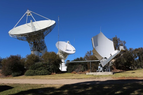
Uralla reference test site. Photo: Lockheed-Martin
To present convincing evidence that it would work, a dual frequency GPS (L1/L2) + Galileo (E1/E5a) reference site has been set up in collaboration with Geoscience Australia and Land Information New Zealand. The reference site is located at Uralla, New South Wales on Australia’s East Coast, where it gathers data demonstrating bounded errors within the operational range which could enable GNSS approach capability.
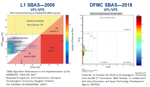
L1 (2006) vs. DFMC (2018) SBAS at Bangkok. Graphic: Lockheed-Martin, GMV
Another test site in Bangkok, Thailand has demonstrated that existing L1-only SBAS in this area cannot manage this performance (all current SBAS are L1 only), but that with dual-frequency multi-constellation (DFMC) GPS L1/L2+Galileo E1/E5a, the required performance limits could be met.
Lockheed Martin has also been using the Uralla uplink site to test the uplink and downlink of dual-frequency SBAS-like test messages.
The Moral of the Story. There are no miracles as yet, but interest in the pay-as-you-go SBAS concept appears to be growing, and the LM/GMV team continues to work to bring their approach to market.
A large number of countries could well benefit from the high accuracy, integrity and continuity of SBAS service if this all comes together.
The scheduled launch of the first GPS III satellite on December 18 was scrubbed, reportedly due to first stage liquid oxygen thermal limit constraints aboard the SpaceX Falcon 9 Block 5 launch vehicle’s first stage reaching safety limits. A second attempt on December 19 was later ruled out due to ongoing evaluations into the sensor issue.
The launch window may open again on Dec. 20.
This was to have been the first GPS launch aboard a SpaceX rocket, as well as the first SpaceX contracted U.S. National Security mission.
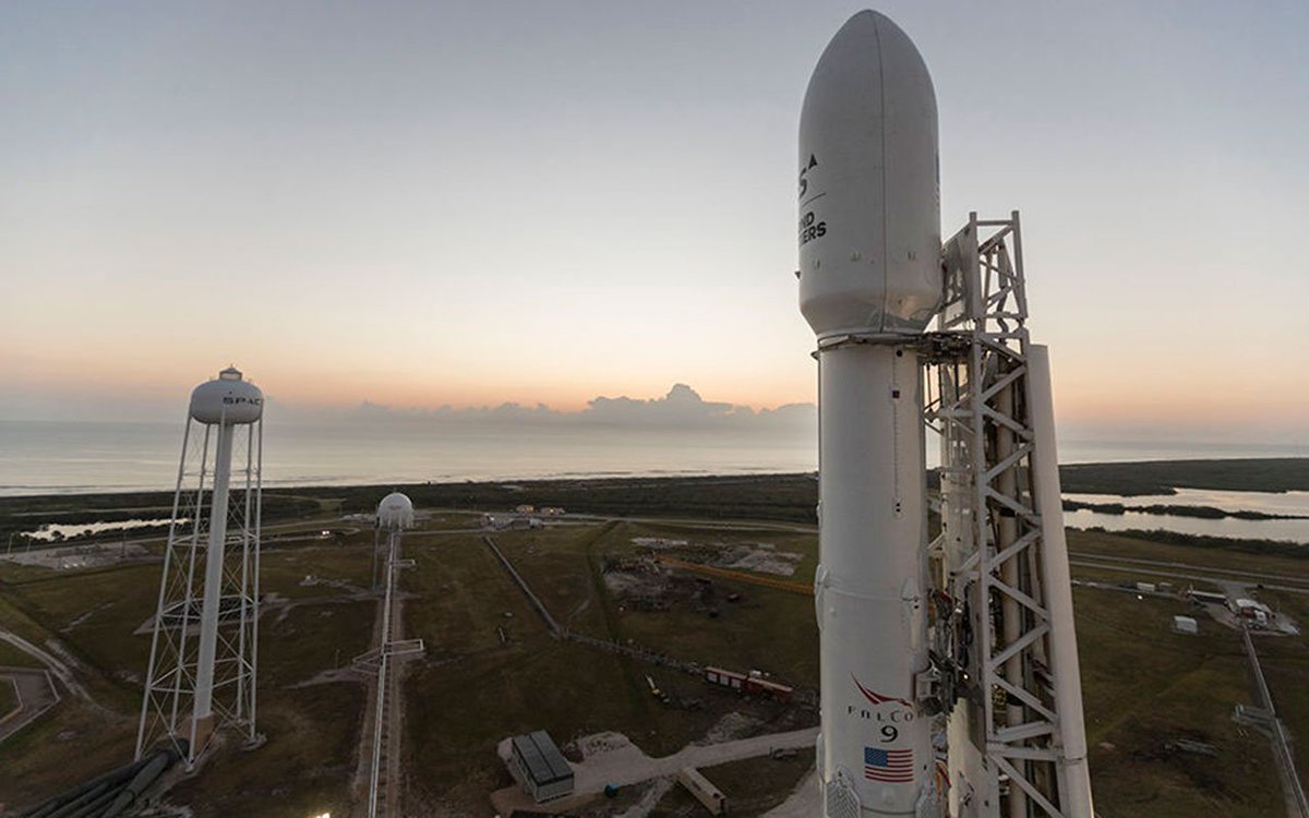
A Falcon 9 rocket awaits launch. (Photo: SpaceX)
The first GPS III satellite was originally scheduled to ride aboard a United Launch Alliance (ULA) Delta IV M+ rocket. ULA and/or its prime partners, Lockheed-Martin and Boeing, have conducted every GPS satellite launch since the start of the program. However, due to an assortment of issues variously involving delayed technology development and lawsuits regarding competitive bidding, the Air Force re-opened bidding for the contract as part of its Evolved Expendable Launch Vehicle (EELV) program — “evolved” signifying that the rocket can be recovered and reused.
Recycling Rockets. ULA did not bid on the re-opened contract, citing concerns over the selection process and potential risks with the anticipated lower launch cost. In 2016, the Air Force selected SpaceX to take over most GPS III launches.
SpaceX’s Falcon 9 for this launch will use a new first stage core, the B1054. Although it has re-use capability, it will fly in an expendable configuration this time, with no landing legs and no grid fins. It will be disposed of into the Atlantic Ocean after separation from the second stage.
In other missions, after the satellite-bearing stage separates from the rest of the rocket, the remaining core launcher fires additional fuel to return intact to land or to sea aboard an Autonomous Spaceport Drone Ship (ASDS), a converted barge awaiting in the Atlantic or Pacific Ocean.
New Generation of GPS. As attentive readers already know, GPS III SV01 is the first of an entirely new design of GPS satellite that will help the Air Force modernize today’s GPS constellation with new technology and advanced capabilities.
GPS III has three times better accuracy and up to eight times improved anti-jamming capabilities. Spacecraft life will extend to 15 years, 25 percent longer than any of the GPS satellites on-orbit today. GPS III’s new L1C civil signal also will make it the first GPS satellite broadcasting a compatible signal with other international global navigation satellite systems, like Galileo, improving connectivity for civilian users.
Lockheed Martin developed GPS III and manufactured GPS III SV01 at its GPS III Processing Facility near Denver. In September 2017, the Air Force declared the satellite “Available for Launch” (AFL) and had the company place it into storage. In 2018, the Air Force called up the satellite for launch and Lockheed Martin delivered it to Florida on Aug. 20. The Air Force nicknamed the satellite “Vespucci” after Italian explorer, navigator and cartographer Amerigo Vespucci.
GPS III SV01 is the first of 10 GPS III satellites originally ordered by the Air Force. GPS III SV03-08 are now in various stages of assembly and test. In August, the Air Force declared the second GPS III AFL and in November called GPS III SV02 up for 2019 launch.
Allystar Technology Co. Ltd., headquartered in Shenzhen, China, has released a multi-band multi-GNSS chipset, the HD9310. The new product is based on the Cynosure III architecture integrating multi-band multi-system GNSS RF and baseband.
A multi-band, multi-system system-on-chip, it supports BeiDou-3 and is capable of tracking all global civil navigation systems (GPS, BeiDou, Galileo, GLONASS, IRNSS, QZSS and SBAS) in all bands (L1, L2, L5, L6), said Simon Sun, Allystar general manager.
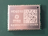
Photo: Allystar Technology
Designed for high-precision applications, the HD9310 measures 5.0mm x 5.0mm. The architecture integrates floating-point arithmetic units based on ARM CortexM4, 160 KB RAM, 32KB backup RAM with VBAT, 386 KB embedded FLASH and peripheral interfaces UART, I2C, SPI, GPIO, CAN.
In terms of the manufacturing processes, it adopts a 40nm process and incorporates a variety of advanced design technologies, endowing it with very power consumption: less than 50mA.
The quad-flat no-leads package allows customers to reduce printed circuit board and bill of materials costs while reducing the number of peripheral devices. This chip supports CAN interface and can be widely used in vehicle management, car navigation, wearable devices, GIS data collection, precision agriculture, smart logistics, driverless, engineering survey and other fields.
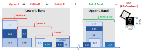
“The HD9310 supports three options of RF setting — A, B, C — for product developers to quickly bring their ideas to the different application and markets,” added Shi Xian Yang, high precision project manager at Allystar.
Three available options for the HD9310 chipset. Graphic: Allystar Technology
Option A, focused on L5 band, L5/E5, maximizes measurement accuracy and improves multipath mitigation based on higher chip rate.
Option B is focused on L2 band, and suitable for relative position applications, for example, real-time kinematic (RTK), because worldwide continuously operating reference stations (CORS) commonly support L1/L2/L1OF/L2OF.
Option C is focused on the L6 band and is designed for PPP applications, receiving state space representation (SSR)-type corrections to be broadcast from satellites in the coming future, and supporting B3I already.
The HD9310 comes with built-in support for standard RTCM Protocol (MSM), supporting multi-band multi-system high-precision raw data output, including pseudo range, phase range, Doppler, SNR for any kind of 3rd party integration and application.
Module. Allystar Technology also has launched a multi-band multi-GNSS module, TAU1302, which integrates the HD9310 chipset and measures 12 × 16 × 2.3 millimeters.
With the features of small size, low power consumption (<50 mA), and ease of integration and mass production, HD9310 is suitable for high-precision applications such as vehicle management, car navigation, wearable devices, GIS data collection, precision agriculture, smart logistics, driverless, engineering survey and other fields.
Customer samples of the HD9310 chipset are available now.
Septentrio has teamed up with Point One Navigation, a provider of precise location as a service, for autonomous vehicle demonstrations during the 2019 International Consumer Electronics Show, which will take place Jan. 8-11 in Las Vegas. During the conference, invitees will be able to ride in a fully autonomous demonstration vehicle that incorporates technology from both companies, as well as meet directly with technical experts, reports GIM International.
During the demonstration, Point One Navigation will showcase its proof-of-concept autonomous vehicle equipped with the the FusionEngine vehicle localization software. According to the company, demonstrations will utilize corrections from Point One’s Polaris Cloud, a new correction network that enables high-precision GPS and computer vision-based localization, while allowing the customer to choose the performance and price point that best fits their application.
According to GIM International, Point One’s solution is powered by Septentrio’s GNSS receivers. For accurate positioning of autonomous vehicles, Septentrio utilizes at least two frequencies broadcast by each GNSS constellation (BeiDou, Galileo, GLONASS, GPS, QZSS), the companies said.
For users operating in open sky scenarios, a Septentrio RTK receiver can be used directly with Polaris Cloud to provide centimeter-level accuracy.
Point One Navigation has chosen to work with Septentrio to power its solutions for both the correction network and our FusionEngine reference design because of the excellent quality, robustness and jamming resistance of their GNSS receiver technology, said Aaron Nathan, CEO and co-founder of Point One Navigation.
United Technologies Corp. (UTC) has completed its acquisition of Rockwell Collins. The two companies will now combine to form Collins Aerospace Systems and be based in Palm Beach City, Florida.
Collins Aerospace Systems will have about 70,000 employees. Rockwell Collins CEO and President Kelly Ortberg will be the CEO of the newly formed company. UTC Aerospace President Dave Gitlin will serve as president.
There are no immediate changes planned as to how many employees will be based in Cedar Rapids, Iowa, or Collins Aerospace’s other locations in Eastern Iowa, said Collins Aerospace spokeswoman Pam Tvrdy-Cleary.
However, the company’s avionics and mission systems will be based in Cedar Rapids. Kent Statler, former Rockwell chief operating officer for commercial systems, will head the avionics unit, and Phil Jasper, former Rockwell chief operating officer for government systems, will be in charge of the mission systems.