InvenSense (TDK Corporation) has introduced a line of automotive high-accuracy devices: the IAM-20680, IAM-20680HP, IAM-20380 and IAM-20381.
According to the company, they are designed to enhance the absolute position of a vehicle in GNSS- and GPS-denied environments.
The IAM-20680 is a 6-axis qualified sensor that features 16-bit accelerometers and 16-bit gyroscopes.
The IAM-20680HP is a high-performance version of the IAM-20680 that features high gyroscope and offset thermal stability.
The IAM-20380 gyroscope is compatible with a 3-axis automotive accelerometer and an automotive-qualified 6-axis device.
The IAM-20381 is a 3-axis accelerometer compatible with a 3-axis automotive gyroscope and an automotive-qualified 6-axis device.
The IAM-20680HP and IAM-20680 can be used to improve estimates of position, direction and speed when GNSS is denied, as well as improve quality of the position estimation when the satellite signal is strong.
Customers can design with the IAM-20680 and can use the IAM-20680HP when navigating in high temperature environments or for systems where cooling is weak or unavailable.
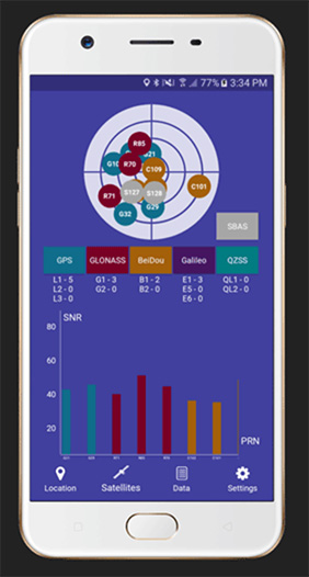
Global GNSS, a subsidiary of Polosoft Technologies, has launched a new mobile application named GNSS Surveyor, which is designed for the geospatial industry.
The application GNSS Surveyor provides location information and quality position data in real-time with sub-meter to centimeter accuracy. It needs to be connected to any external GNSS receiver via Bluetooth.
Features of the application include:
A one-touch configured command to communicate directly with the GNSS Bluetooth device.
Location information and quality of the position data in real-time with centimeter accuracy.
GPS data such as position, height, satellites and velocity.
Constellation information for GPS, GLONASS, Galileo, BeiDou, QZSS and SBAS satellites in the orbit.
Direct IP feature for RTK corrections data.
DMS to DD conversion or vice versa.
Real-time kinematic (RTK) correction data can be forwarded to a high-accuracy external device. The internal NTRIP client loads the RTCM data from the internet.
With GNSS Surveyor, location information is collected as latitude and longitude, altitude, speed or pace, bearing and UTC time.
GNSS precision includes global coverage, centimeter-level accuracy, fast time to first fix, multi-constellation and multi-band, and highest security, the company said.
Navigation uses include ground robotics navigation, lane-level navigation, heavy machine navigation, industrial navigation and tracking and commercial UAV.
WTS Positioning Solutions, a Swedish GPS tracking company, has released its next generation of smart GPS trackers: the Trax G+ series.
At the top of the range is Trax G+ 4G LTE-M, one of the first LTE trackers commercially available on the market, the company said. It supports 4G LTE-M and NB-IoT standards, with both European and U.S. models available.
WTS has also released two new, improved GPS models using 3G and 2G standards, to complete the new Trax G+ range.
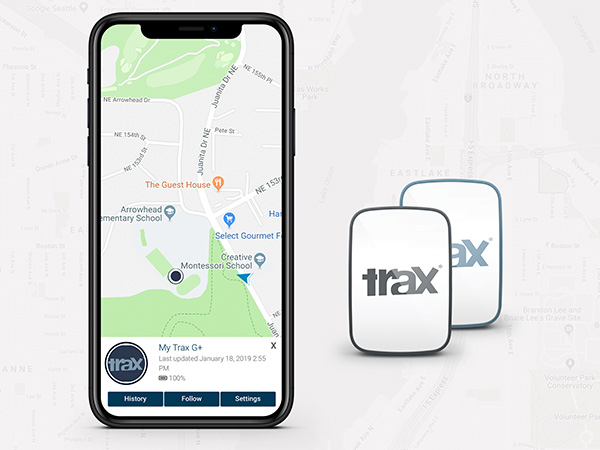
Trax G+ tracker. Trax G+ is a small GPS tracker for personal use. It has real-time tracking capability with update rates of up to every 10 seconds. For customised industrial applications, the new Trax G+ can support up to two updates per second. It also comes with wireless charging and IP68 water resistance.
The Trax G+ App, available in the App Store and Google Play, has a wide range of features including Unlimited Geofences, Augmented Reality Tracking, Speed Alerts, Location History, the possibility to track multiple devices and device sharing.
WTS works closely with brands across several consumer markets, including sports gear, event management, security, search and rescue, homecare and telecommunications.
Photo: WTS Positioning Solutions
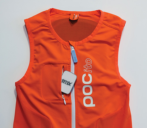
Tracking vest. A special collaboration with POC sports brand, manufacturer of helmets, body armour and sports apparel, resulted in an ISPO Gold Winner award for the POCito VPD Air Vest + TRAX POC edition.
The vest provides a child with back protection for winter sports and is designed to store a TRAX POC Edition device. It is an integrated protection, alert and tracking system that allows parents to monitor and keep children safe on the slopes.
POC will present the vest at ISPO Munich, held Fe.b 3-6, in Hall B6, Booth 414.
Trax G+ data plans are offered in 6-, 12- and 24-month pre-paid packages and offer international coverage and free roaming in all supported countries.
WTS Positioning Solutions are specialists within the GNSS industry, supplying personal GPS trackers, plus customised hardware, software, server and data solutions for high-precision real-time location and tracking information.
Virtual Surveyor drone surveying and mapping software has added new functionality that enables users to process larger projects without buying more powerful computers or cloud services, according to the company. This addition is one of several included in Virtual Surveyor 6.2.
“Our objective with Version 6.2 is to make our users more productive while saving them money by eliminating the need to invest in new hardware or processing services,” said Tom Op ‘t Eyndt, CEO of Virtual Surveyor in Belgium. “We have addressed the fact that drones are capturing more data at higher resolution, resulting in enormous files sizes.”
According to the company, Virtual Surveyor 6.2 solves the problem of large files by offering enhanced clipping and mosaicking functionality. The new version allows users to merge multiple smaller processed pieces of orthophotos and digital surface models into a single project and create smooth edges between these pieces with the new clipping tool. The mosaic can then be exported to a new tiff file or serve as the basis for a full area virtual survey.
In addition, Virtual Surveyor 6.2 offers a 3D Fly Through capability that allows users to select spatial bookmarks and waypoints in their scene and create a movie that allows the viewer to fly through the terrain in three dimensions.
Virtual Surveyor 6.2 also features improved surface handling for volume calculations. This feature was developed primarily for users who measure volumetrics of material piles in drone survey data. This capability makes it easy to represent topographies as triangles, contour lines or outlines without creating three different objects, the company said.
Other enhanced features of Virtual Surveyor 6.2 include a renumbering tool that allows users to select a set of times, features or geometries in the data set and automatically number them sequentially from any chosen starting number; concave hull extraction that allows users to select a section line to create a surface for a curved roadway; and boundary selection that allows users to trace around an unwanted feature and delete that object and all the points within it.
“The advantage of Virtual Surveyor is that it combines the interpretation skill of a professional surveyor with computing power to create standard survey products,” said Op ‘t Eyndt. “Surveyors can now accomplish more in Version 6.2 without expensive upgrades to other aspects of their workflow.”
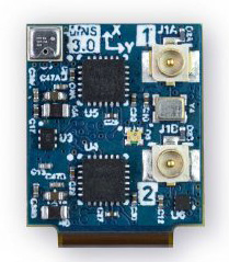
Dime-sized INS with RTK paves the way for high accuracy in mass-market consumer applications.
Photo: Inertial Sense
Inertial Sense has released a new micro-sized inertial navigation system (INS) with precise real-time-kinematic (RTK)-level accuracy. The company says the new solution paves the way for high accuracy in mass-market consumer applications.
The new micro INS with RTK solution offers an accuracy of 2-3 centimeters using GPS positioning in combination with inertial sensors (including on-board sensor fusion).
Inertial Sense designs and manufactures precision INS+RTK GPS sensors that deliver fast, accurate and reliable altitude, velocity and position for a wide range of autonomous vehicle applications, the company said.
The new micro INS with RTK provides a high degree of precision for orientation and GPS in a tiny package. Standard INS/GPS sensors offer accuracy in the range of 1.5 to 2 meters. Inertial Sense’s micro INS with RTK offers accuracy of 2-3 centimeters.
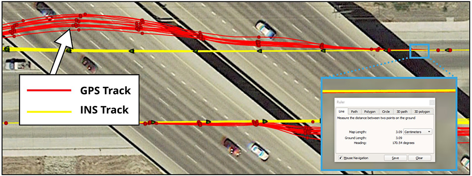
In the image above, a vehicle travels under an overpass. The 3-cm accurate RTK-inertial navigation track holds true to the vehicle’s position while the standard GPS signal is lost. (Image: Inertial Sense)
“The incredibly small size of our new micro INS with RTK sensor, in combination with its extremely affordable price point, will make this type of highly sophisticated technology accessible for general consumer applications for the very first time,” said Walt Johnson, founder and CTO, Inertial Sense. “We are offering RTK at a size, accuracy and price point that the market has never seen before.”
By optimizing the manufacturing processes for high volume applications, the micro INS with RTK sensor is as small and lightweight as a dime, and is available at a low price point.
Sensor fusion. Sensor data from MEMs gyros, accelerometers, magnetometers, barometric pressure and u-blox GPS/GNSS are fused to provide optimal position estimation. Data out includes angular rate, linear acceleration, magnetic field, barometric altitude and GPS time.
The miniature module provides orientation, velocity and position. Base station corrections data can be applied to achieve centimeter-level precision.
Autonomous vehicles. The sensor will enable the navigation of all types of autonomous vehicles with a very high degree of precision, Inertial Sense said.
Inertial Sense patented modules are currently being sold worldwide at volume for a broad variety of applications including:
Aerial surveys: UAV Payloads for 3D mapping, photogrammetry, orthomosaics
Gimbal stabilization and antenna pointing
3D motion capture and personnel tracking
Evaluation kits. Inertial Sense has bundled evaluation kits it says are simple to use and contain everything needed to begin logging RTK-accurate data. The evaluation boards can be utilized in both rover and base station configurations and include 900-mhz radios with onboard logging capabilities.
Centimeter-accurate, multi-constellation, multi-band, dual-antenna, RTK and affordable GNSS/INS solution
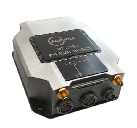
Aceinna is offering the INS1000 high-performance dual-band real-time kinematic inertial navigation system (RTK INS) with built-in inertial sensors for construction, agriculture and automotive applications.
Aceinna has also launched an OpenIMU package for autonomous vehicle guidance and navigation.
INS1o00
Photo: Aceinna
The INS1000 embeds Aceinna’s nine-degree-of-freedom inertial sensor technology to achieve automotive dead-reckoning performance in GNSS-challenged environments like urban canyons, heavily tree-lined roads, tunnels, underpasses and bridges.
The dual-frequency RTK and tight coupling between GNSS and inertial sensors provide centimeter-level accuracy, enhanced reliability, and superior performance during GNSS outages, the company said.
“Without access to satellite delivered guidance and localization information, autonomous vehicles can quickly get off track,” says Mike Horton, CTO of Aceinna. “The INS1000 delivers the essential detailed position and heading accuracy at a price point that is suitable for startups as well as fleet-wide vehicle deployment. As the leading supplier to the precision agriculture autosteer market, Aceinna is focused on driving the cost and complexity out of GNSS/INS solutions to enable widespread adoption in automotive ADAS applications.”
INS1000 is an integrated navigation system consisting of an inertial measurement unit (IMU) and other sensors. It provides the position, velocity and attitude information of the vehicle. A dual-frequency (L1/L2), dual-antenna GNSS receiver is used as the primary aiding sensor. Also supported is a distance measurement indicator (DMI) which can be attached to a wheel of the vehicle/robot to measure the rotation rate of the wheel. Integration of a DMI would give an improved solution in challenging environments: urban canyons, tunnels, warehouses and indoor facilities and campuses.
With horizontal position accuracy of 2cm (RTK), vertical position accuracy of 3cm (RTK), and velocity accuracies of 0.01m/s and 0.02m/s (horizontal and vertical, respectively), the INS1000 provides the precision navigation capabilities required for the automotive autonomous, automotive track testing, precision agriculture, and construction markets.
The INS1000 is compatible with all major global satellite systems (GPS, GLONASS, Beidou, Galileo, SBAS); it supports USB, Ethernet, CAN and RS-232 interfaces; and it supports dual GNSS antennas for accurate heading in static and dynamic scenarios, and difficult magnetic environments.
The easy-to-use embedded software allows extensive configuration and diagnostic capabilities. For optimal flexibility, the tools enable configuration of the output position, initialization of heading, IMU transformation matrix, GNSS antenna lever-arms, and NTRIP client. The control software can log and decode output data from the system or use the web application to plot results on a map.
Open IMU Package
Aceinna also offers an OpenIMU package. Its three key parts are:
a family of IMUs (three high-accuracy accelerometers, three high-accuracy gyros, and a powerful ARM Coretex);
an OpenSource tool chain and reference code for programming the IMU, with everything from basic download and debug to reference implementations of loosely coupled GPS/INS
a full developer site and tools with charting, graphing and algorithm simulation.
The Federal Railroad Administration (FRA) has awarded $46,301,702 in grant funding for 11 projects in 10 states to assist with deploying positive train control (PTC) systems.
This marks the second selection of PTC systems deployment projects under the Fiscal Year (FY) 2018 Consolidated Appropriations Act and via the Consolidated Rail Infrastructure and Safety Improvements (CRISI) Program, collectively totaling $250 million in funding.
Photo: gabriel12/Shutterstock.com
“These $46 million in grants will speed up the deployment of positive train control systems, a key element in strengthening safety for both passenger and freight railroads,” U.S. Transportation Secretary Elaine L. Chao said. “Each recipient will be held accountable for achieving specific, measurable outcomes.”
The CRISI Program was authorized by the Fixing America’s Surface Transportation (FAST) Act to provide funding to improve the safety, efficiency, and reliability of intercity passenger rail and freight rail transportation systems. The FY 2018 Consolidated Appropriations Act provided $592,547,000 for the CRISI Program, with $250,000,000 to be made available for PTC system deployment. On August 24, 2018, FRA announced $203.7 million in grant awards for PTC implementation to 28 projects in 15 states.
“These grants not only help railroads continue to make progress implementing positive train control, but they also show that we’re steadfast in our commitment to make investments in passenger rail and rural communities,” said FRA Administrator Ronald L. Batory.
In this second round of FY 2018 PTC CRISI grants, 100 percent of the funds will benefit passenger rail, with about 31 percent — or $14 million — benefiting rural projects. The CRISI grant program directs much-needed critical investment — at least 25 percent of available funds — to rural America.
The awards will fund many aspects of PTC system implementation for intercity passenger or commuter rail and freight rail transportation, including back office PTC systems; wayside, communications, and onboard PTC system equipment; personnel training; PTC system testing; and interoperability.
In 2008, Congress mandated implementation of PTC systems on the main lines of Class I railroads and entities providing regularly scheduled intercity or commuter rail passenger transportation over which hazardous materials are transported, or over which intercity or commuter rail passenger transportation is regularly provided.
In October 2015, Congress extended the original PTC system implementation deadline from Dec. 31, 2015, to Dec. 31, 2018. In addition, Congress requires FRA to approve a railroad’s request for an “alternative schedule” with a deadline for full implementation beyond Dec. 31, 2018, but not later than Dec. 31, 2020, if the railroad demonstrates it has met the congressionally mandated criteria for an alternative schedule.
FRA awarded grants in the approximate amounts below to the following programs and entities:
AK – GPS Precision Upgrade for PTC (Up to $2,530,618) Alaska Railroad Corporation (ARRC)
For this rural project, ARRC will procure a platform with software to improve the accuracy and functionality of the global positioning system (GPS) in ARRC’s locomotives and on-track equipment, and implement the vital functions for its Interoperable Electronic Train Management System (I-ETMS).
CA – PTC Configuration Management and Office Segment Failover (Up to $3,976,560) Peninsula Corridor Joint Powers Board (Caltrain)
To implement Caltrain’s I-ETMS PTC system, this grant will fund the completion of a Caltrain PTC Configuration Management (CM) Plan and PTC Data Management Procedure; development of a CM tool that generates an audit trail for changes to configuration data and CM training on the configuration control and CM process; completion of the backup central control facility (BCCF) and Central Control Facility Failover Design and Test Plan; and completion of the design, test results, and as-built system for an Emergency Operation Center at the existing BCCF in Menlo Park, Calif.
CA – Leveraging PTC to Increase Capacity and Reduce Headways and Alternative Vendor Analysis (Up to $3,150,000) Southern California Regional Rail Authority (SCRRA or Metrolink)
This project will include a study for leveraging PTC to increase capacity and reduce headways, software development, PTC component upgrades, and/or corridor infrastructure upgrades to support the future implementation of Higher Reliability and Capacity Train Control (HRCTC) along Metrolink’s congested Orange County Line from Los Angeles Union Station to Oceanside, Calif.
CO – PTC Installation for the Amtrak Southwest Chief on BNSF Railway Through Colorado and Kansas (Up to $9,157,600) Colorado Department of Transportation (CDOT)
This rural project from CDOT, in collaboration with the Kansas Department of Transportation (KDOT) and BNSF, includes the design, installation, and testing of I-ETMS PTC wayside technology on approximately 179 miles of a predominantly single-track route between Dodge City, Kan., and Las Animas, Colo.
IL – PTC Kits and Spare Parts for 24 Additional Locomotives at Metra (Up to $2,058,163) Commuter Rail Division of the Regional Transportation Authority (Metra)
The project includes purchasing and installing onboard I-ETMS PTC equipment on Metra’s 24 recently purchased locomotives.
MA – MBTA PTC Implementation (Up to $7,548,335) Massachusetts Bay Transportation Authority (MBTA)
This project on the Needham Branch, Franklin Branch, and Worcester Line, includes two components: 1) Testing of Automatic Train Control (ATC), where the previously installed PTC/ATC equipment on each line is already wired, and the software is loaded, connected to the signal system, and activated. The testing is intended to confirm the equipment functions as designed and is ready for testing with a test train. 2) “Completion of Commissioning for the ATC Lines,” where final acceptance testing is performed, including interoperability and ATC system testing.
NC – NCDOT Rolling Stock PTC Commissioning (Up to $584,080) North Carolina Department of Transportation (NCDOT)
The project includes installing, testing, commissioning, and certifying I-ETMS PTC onboard technology on three NCDOT locomotives for operation in the Piedmont intercity passenger rail service, which operates between Raleigh and Charlotte, N.C.
NJ – PTC Installation on Multi-level Cab Cars (Up to $6,542,353) New Jersey Transit Corporation (NJT)
This project will install and test Advanced Speed Enforcement System II (ASES II) PTC onboard equipment on 33 new NJT multilevel cab cars for deployment along the Northeast Corridor, Montclair-Boonton, and Morris & Essex Lines in New Jersey.
NM – New Mexico Rail Runner Express PTC/Wi-Fi Integration Project (Up to $2,496,842) Rio Metro Regional Transit District (Rio Metro)
This rural project will restore the New Mexico Rail Runner Express (NMRX) system’s Wi-Fi network from an end-of-life, proprietary WiMAX system to a cross-compatible Long-Term Evolution (LTE) system, providing a redundant path of communication for its I-ETMS PTC system. The project will install 26 towers along the 96 miles of the NMRX system between Belen, N.M. and Santa Fe, N.M., including approximately 74 miles of the Albuquerque Subdivision and 22 miles of the Santa Fe Subdivision. Nine NMRX cab cars, 13 coach cars, and 15 NMRX stations will be equipped with the Wi-Fi technology necessary for its PTC system.
NY – MTA Metro-North Railroad PTC Communications Testing (Up to $2,300,000) NY Metropolitan Transportation Authority (MTA)
This project will involve PTC system testing to measure communications system performance to predict, identify, and replicate communications issues affecting MTA’s Metro-North Railroad’s operations, as well as develop and validate mitigation approaches to address communications challenges along the Northeast Corridor.
TX – Capital Metro E-ATC PTC Wayside Installation Project (Up to $5,957,151) Capital Metropolitan Transportation Authority (Capital Metro)
This project includes the design, installation, and verification of the Enhanced Automatic Train Control PTC wayside system on the new tracks along Capital Metro’s Red Line in the cities of Austin, Cedar Park, Leander, and the surrounding Texas communities. The new project spans a 21-mile section along the Red Line on Capital Metro’s commuter rail corridor.
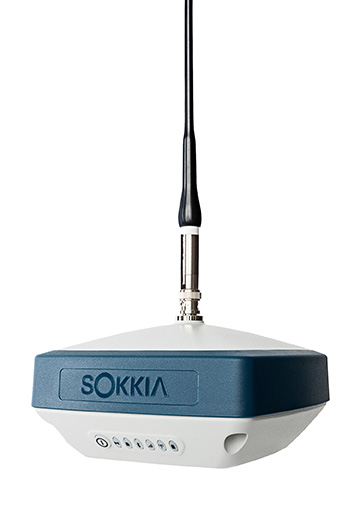
Sokkia introduced the latest addition to its GNSS integrated receiver line — the GRX3. According to the company, the GRX3 is designed to provide a smaller, lighter and fully integrated GNSS solution.
Photo: Sokkia
“The multi-constellation GRX3 receiver is built to offer a complete and versatile solution to provide best-in-class positioning performance for a wide variety of precision applications,” said Alok Srivastava, director of product management.
“Whether using the receiver for GNSS post-processed surveying, or RTK using wireless technologies including network RTK option with a cellular-equipped field computer, a SiteComm RTK rover, or paired with a Sokkia total station for fusion positioning, the GRX3 provides the most advanced and powerful GNSS technology available in a more compact and lightweight housing that can withstand the harshest of environmental conditions. Combine it with one of Sokkia’s data collectors and field software for maximum versatility and convenience, increasing fieldwork efficiency from start to finish.”
The receiver features Sokkia Tilt technology, which includes a 9-axis inertial measurement unit and ultra-compact eCompass designed to compensate for mis-leveled field measurements by as much as 15 degrees.
“The GRX3 is designed as a ‘future-proof’ solution with an advanced GNSS chipset with Universal Tracking Channels technology that automatically tracks signals from all available and planned constellations — including GPS, GLONASS, Galileo, Beidou, IRNSS, QZSS, SBAS,” Srivastava said.
The receiver has been tested to meet IP67 certification for protection against harsh environmental weather conditions.
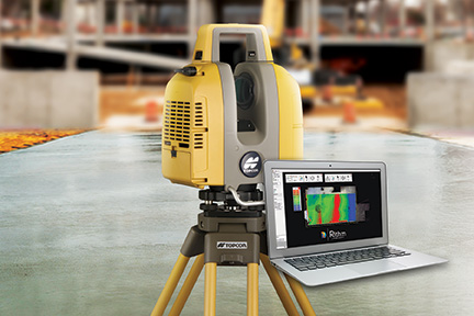
Topcon Positioning Group released a new workflow bundle designed to modernize concrete FFL (floor flatness and levelness) applications.
A new ClearEdge3D development and sales partnership with a leader and pioneer in 3D laser scanning software for construction QA/QC, Rithm, is prominently advancing the Topcon concrete application offering with a new hardware and software bundle option.
It is part of the Topcon comprehensive approach to modernize core concrete applications such as layout, quality control and concrete screed with the latest capabilities in precise positioning technology.
Implementing Rithm on projects for wet, or dry concrete scanning is designed to allow the opportunity to perform FFL analysis directly from scan data loaded into the Autodesk Navisworks software. Operators can find floor flatness and levelness mistakes in near real time from scan-to-finish. The data Rithm provides allows project teams to easily visualize high and low areas with elevation and deviation heat-maps and contour maps.
“By bundling this software with Topcon’s GLS-2000 scanner, contractors can improve their QA workflows to reduce floor profiling costs by performing FFL analysis in-house in near real time,” said Alok Srivastava, Topcon director of product management. “Through the integration with Navisworks, Rithm provides contractors fast, and detailed ASTM E1155 compliant FFL reports with streamlined floor flatness and levelness analysis, thereby cutting down time on waiting for scanning analysis, increasing productivity.
“The integrated workflow including the GLS-2000, post-processing with MAGNET Collage and QA analysis with Rithm software achieves an optimized end-to-end workflow — from the hardware to software end deliverables,” said Srivastava.
The new real-time FFL application is part of an overarching Topcon approach to modernize concrete applications with precise positioning technology.
Topcon GT series robotic total stations combined with integrated MAGNET software incorporate a BIM-integrated workflow to layout and verify construction quality in the field.
Additionally, Topcon offers machine control systems for robotic concrete screed applications. After importing an easily created 3D model, concrete can be poured and placed more efficiently with advanced screed technology designed to dramatically speed up the screed process and increase quality with precision-guided machine control.
“With our real-time position information constantly updating, you efficiently manage material as it’s placed — delivering the highest quality in a fraction of the time,” Srivastava said.
The European GNSS Agency (GSA) is organizing a public consultation on the Integrity & Reliability of Digital Maps for Connected and Automated Driving, in connection with the recently published Commission Communication on Connected and Automated Mobility.
This communication addresses the need to investigate the integrity and reliability of digital maps in order to facilitate the deployment of fully automated and connected vehicles.
Image: GSA
Digital maps are an essential building block to ensure a safe driving experience for highly automated driving and autonomous vehicles. Purpose-built maps will be produced that will be much more reliable and accurate than those used for traditional applications.
These digital maps will be enriched with information from public databases and sensor data from connected vehicles. Traffic information, such as speed limits or the real-time dynamics of traffic flow, will help the vehicle’s navigation system to anticipate upcoming road conditions and take decisions beyond what is enabled by the vehicle’s on-board sensors.
Key role for GNSS
Satellite navigation (GNSS), and in particular Galileo, plays a key role in providing precise and secure positioning in vehicle navigation technologies for driverless mobility. Moreover, GNSS is the primary sensor for building digital maps to provide very accurate positioning together with other sensors, such as LiDAR, for example.
Dynamic data pose specific problems, particularly given their real-time nature: they must be generated, validated and made available to the user equipment without delay. This makes their integrity validation more challenging, and their transmission can be subject to errors or disruptions affecting the overall reliability.
Addressing the issue
Currently, it is the navigation and map provider’s responsibility to ensure the integrity of its products and the reliability of the information provided by third-party suppliers. However, until now the maps have been mainly used to support navigation, giving information to the driver, rather than to support safety-related functions.
Some industry standards exist or are being developed for data exchange and map content, but there are currently no specific standards or certification procedures to assess map data quality characteristics, such as reliability, integrity, and traceability. This public consultation is a starting point in addressing this issue.
Have your say
The public consultation can be accessed here. It will be open until Jan. 27.
Fugro has completed a landmark data acquisition campaign over the Turks and Caicos Islands, marking the first commercial success of its new Rapid Airborne Multibeam Mapping System (RAMMS).
Working under contract to the United Kingdom Hydrographic Office (UKHO), the company acquired more than 7,400 square kilometers of integrated, high-resolution bathymetric, topographic and image data. The resulting deliverables will support updated nautical charts and coastal zone management activities in the region.
Launched in August 2018, RAMMS is a highly efficient, next-generation airborne bathymetric mapping system that uses multibeam laser technology to deliver depth penetration and point densities, the company said. The compact sensor is deployed from small aircraft and can be integrated with other remote sensing technologies for simultaneous collection of multiple complementary datasets.
For the Turks and Caicos project, this approach made it possible to acquire near-shore (bathymetry) and coastal (topography and imagery) data in a single deployment, producing a cost-effective solution and advancing Fugro’s sustainability goals by significantly reducing fuel consumption.
“After years of development, it’s extremely gratifying to operate RAMMS commercially and to demonstrate to clients the value that this cutting-edge technology can bring,” said Mark MacDonald, Fugro Americas Marine Division hydrographic service line director.
He pointed to the massive Turks and Caicos project as an example. “The system’s multibeam lidar capability allowed us to achieve point densities that otherwise would have required vessel-based surveys. With RAMMS, we were able to avoid that additional time and expense, and significantly reduce health and safety exposure.”
Fugro is working on three additional RAMMS projects in the Americas region, one for UKHO in Belize, and two for the Canadian Hydrographic Society, in Quebec and Atlantic Canada. These projects are similar in scope to that of the Turks and Caicos project, combining bathymetry, topography and imagery for maximum value to clients, serving both navigation and coastal applications.
Based on steady interest in RAMMS, Fugro and technology partner Areté Associates are building an additional system to meet anticipated contracting volumes in 2019.
Fugro is also finalizing a cloud-processing capability, which will further improve client delivery by streamlining data review and approvals, and ultimately making data available for download-on-demand.
Additionally, Fugro aims to operate the unmanned aerial vehicle-proven system autonomously in 2019, providing further operational efficiency gains and increasing access to remote project areas.
Orthometric height support (survey-grade elevations) enables Arrow GNSS receivers to collect high-accuracy, survey-grade vertical data with any data-collection software.
Eos Positioning Systems Inc. has added support for GEOID height models within its Arrow Series GNSS receivers. Eos manufactures high-accuracy GNSS receivers for any app running on iOS/Android/Windows devices and using the Eos Arrow Series.
“You can use Arrow Series receivers with any data-collection software in the world, and benefit from accurate orthometric heights,” Eos CTO Jean-Yves Lauture said. “Our Arrow receivers will output accurate GNSS elevations no matter which data-collection software you use to capture it.”
Image: Eos Positioning
With support for GEOID models, Arrow receivers automatically output survey-grade elevations to all iOS and Android data collection software. Support will also soon be available for Windows devices.
The Arrow receivers now support the entire United States to provide survey-grade elevation in NAVD88 orthometric heights through the GEOID12B (US) model. The Arrow receivers also support the Canadian CGG2013a and HTv2.0 GEOID models for the CGVD2013 and CGVD28 vertical datums, respectively. Additional GEOID models for other countries are planned.
“Eos is intensely focused on supporting high-accuracy GIS, engineering, surveying and construction users by supporting the latest GEOID elevation models within our GNSS monitoring software,” Lauture said. “Our roadmap remains focused on high-accuracy BYOD users by supporting all iOS, Android and Windows users with this capability.”
The problem is that typical Bluetooth GNSS receivers usually provide inaccurate, built-in elevation models. This inaccuracy is reflected in the Mean Sea Level elevation output by those receivers. By outputting orthometric height, the Arrow now solves this problem and turns any smartphone or tablet into a 3D, survey-grade accurate data collection device, the company said.
Eos has designed this new feature so that users will easily be able to update to new GEOID models as they become available.
Field technicians in pipeline, construction, engineering, architecture, water and any other industry are finally able to enjoy GNSS location with survey-grade vertical accuracy on their iOS and Android devices, with the data-collection app of their choice and their Eos Arrow receivers.