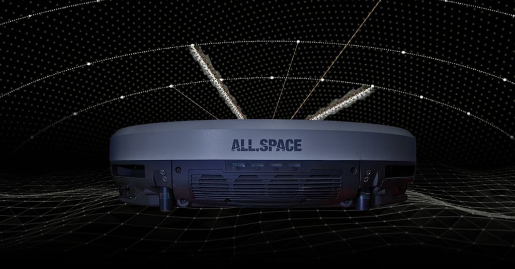
All.Space, a provider of multi-orbit, multi-link satcom omplatforms, has been awarded €950,000 by the European Space Agency’s Navigation Innovation and Support Programme (NAVISP). The award is to develop an alternative position, navigation and timing (PNT) capability designed to operate in GNSS-denied environments.
The project will build a proof of concept for alternative PNT, harnessing All.Space’s multi-orbit terminal technology to generate and analyze signals of opportunity that can deliver position and orientation data independently from traditional GNSS sources.
The technology is designed to counter rising threats from GNSS jamming and spoofing – scenarios of increasing concern for both defence and commercial operators. Delivered in partnership with UK-based GNSS experts GMV NSL, the project is aimed at embedding a resilient PNT capability directly within the All.Space terminal, forming part of its growing software as a service (SaaS) portfolio.
“GNSS denial is no longer a hypothetical scenario,” said Paul McCarter, CEO at All.Space. “It’s a growing reality. With this project we’re developing a sovereign alternative that can restore confidence, capability and control in even the most contested environments.”
Once proven, the technology will be matured and commercialized as an integrated service offering, helping customers achieve operational independence and secure navigation in any domain.
ESA’s NAVISP programme is designed to spur innovation in navigation technologies and services across its Member States.
Adtran‘s Oscilloquartz synchronization platforms now support Galileo’s Open Service Navigation Message Authentication (OSNMA). OSNMA is a GNSS authentication service designed for civilian use.
By verifying that timing data originates from genuine Galileo satellites, OSNMA ensures authenticity and integrity at the point of reception. The new feature, available via firmware update for supported multi-band GNSS receivers, adds an extra layer of protection against spoofing and manipulation, empowering existing deployments to strengthen security without hardware changes or service disruption.
OSNMA support from Adtran brings a new level of GNSS security to critical infrastructure. Available for multi-band GNSS receivers in the OSA 5412, OSA 5422, OSA 5430 and OSA 5440 product lines, the feature integrates with Galileo’s Open Service, using digital signatures and TESLA chain keys to authenticate navigation data. This ensures that timing and positioning information is verified as authentic and protected against spoofing or manipulation.
Adtran’s Oscilloquartz Syncjack probing adds a second layer of defense, detecting record-and-replay attacks – also known as meaconing – by comparing GNSS signals against trusted PTP sources. This dual-layer approach helps identify subtle timing manipulations and delay attacks that traditional receivers may miss.
“From 5G and smart power grids to financial networks and data centers, bringing authentication to GNSS is a game changer for critical infrastructure,” said Gil Biran, GM of Oscilloquartz, Adtran. “By enabling our customers to defend against sophisticated threats, including meaconing, we’re helping them achieve greater timing integrity for their networks. Existing customers can access this new GNSS security feature with a simple firmware update, helping them stay protected as threats continue to evolve.”
Net Insight has launched TN3100E, a TimeNode in the Zyntai family built for markets that demand enhanced timing resilience in challenging environments. The TN3100E delivers multiband GNSS for superior accuracy, supports India’s GNSS IRNSS/NavIC, and adds advanced anti-jamming and anti-spoofing features.
The TN3100E is the latest TimeNode hardware unit in the Zyntai product family. It provides enhanced GNSS functionalities designed for markets that depend on GNSS as time source in challenging environments where robust protection against interference is essential.
The TN3100E introduces new capabilities for Improved anti-jamming and anti-spoofing. TN3100E fully supports the Open Service Navigation Message Authentication (OSNMA) used by Galileo to verify signal authenticity. This, together with Net Insight’s time-based anti-spoofing techniques, enables the TN3100E to deliver a high level of anti-spoofing protection.
TN3100E is commercially available now. Visit Net Insight’s booth 24 at ITSF 2025 Oct. 27–30 in Prague.
Microchip Technology has released the TimeProvider 4500 v3 grandmaster clock (TP4500) designed to deliver sub-nanosecond accuracy for time distribution across 800 km long-haul optical transmission.
Most current deployments require GNSS at grandmaster sites, but the TP4500 enables highly resilient synchronization without relying on GNSS, providing critical infrastructure operators with complementary positioning, navigation and timing (PNT). The TP4500 is a resilient, terrestrial solution for the absence of GNSS in precise timing, alleviating physical obstruction, security and signal interference costs associated with GNSS-dependent deployments.
The TP4500 supports time reference provided by UTC(k) UTC time provided by national labs. It offers a premium capability that delivers High Accuracy Time Transfer (HA-TT) as defined by ITU-T G.8271.1/Y.1366.1 (01/2024) to meet 5 nanoseconds (ns) time delay over 800 km (equating to 500 picoseconds (ps) average per node, assuming 10 nodes), setting a new industry benchmark for accuracy.
The TP4500 system can be configured with multiple operation modes to form an end-to-end architecture known as virtual PRTC (vPRTC), capable of delivering PRTC accuracy over a long-distance optical network. vPRTC is a carrier-grade architecture for terrestrial distribution of HA-TT, which has been widely deployed in operator networks throughout the world.
TimeProvider 4500 v3 is a key steppingstone towards support of the ITU-T G.8272.2 standard, which defines a coherent network reference time clock (cnPRTC) in amendment 2 (2024). An cnPRTC architecture ensures highly accurate, resilient, and robust timekeeping throughout a telecom network. This allows stable, network-wide ePRTC time accuracy, even during periods of regional or network-wide GNSS unavailability or other failures and interruptions.
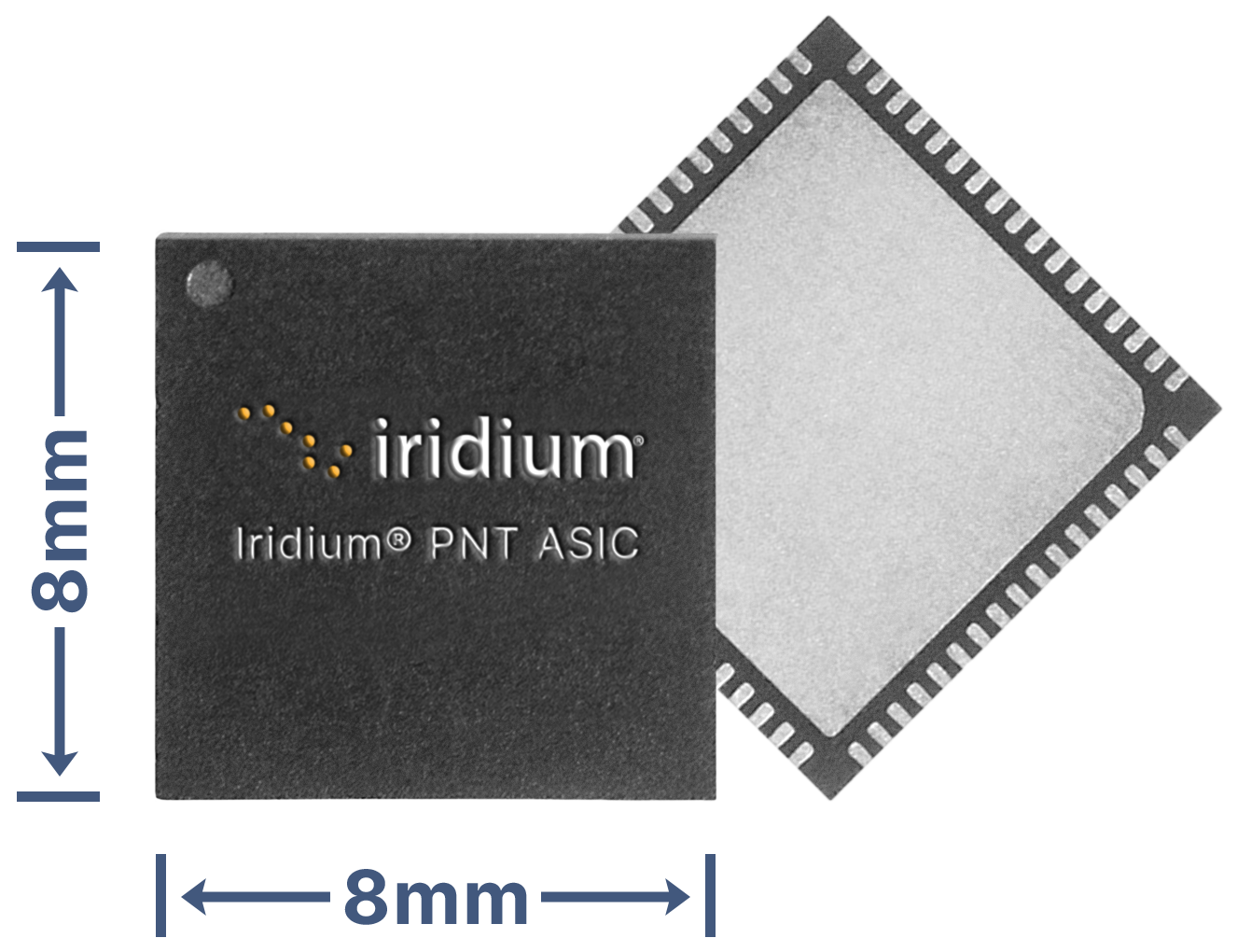
Iridium Communications Inc. has unveiled a dedicated, miniature application-specific integrated circuit (ASIC), the Iridium PNT ASIC. Engineered for seamless integration into a wide range of electronic devices, the Iridium PNT ASIC will deliver authenticated, pole-to-pole positioning, navigation and timing (PNT) data. It will provide a resilient alternative to traditional GNSS, offering protection against spoofing and jamming for consumer, industrial and government applications.
The Iridium PNT ASIC measures 8 x 8 mm and can be fit into devices ranging in size from consumer products to major infrastructure systems like power grids, transportation systems and telecom networks. When embedded in a device, the Iridium PNT ASIC receives a cryptographically secure time and location data signal from the Iridium satellite network that is 1,000 times more powerful than GPS and capable of working inside buildings. This can help GNSS-dependent applications to not only detect a problem but also maintain operations until it is resolved. The Iridium PNT ASIC will also continuously verify signal integrity, making it a suiitable alternative or primary source of PNT data.
Iridium showcased the ASIC’s capabilities during September’s Jammertest, an annual event that evaluates the resilience of GNSS and alternative PNT technologies under jamming and spoofing attacks. The Iridium PNT ASIC maintained both timing accuracy and reliable navigation during controlled exercises.
Iridium is inviting organizations to apply to participate in beta trials, and, if selected, they will receive Iridium PNT ASIC evaluation kits, enabling early integration and testing. The Iridium PNT ASIC is planned for commercial availability in mid-2026.
Safran Electronics & Defense had unveiled Skydel NAVWAR, a software solution designed to protect against hostile UAVs by disrupting their navigation systems.
As the core of Safran’s counter-UAV (C-UAV) systems, Skydel NAVWAR disrupts UAV navigation by simulating authentic GNSS signals, providing nations and organizations with advanced protection for their most critical assets.
Skydel NAVWAR can be deployed on tactical platforms and integrated with sensors and command-and-control systems, allowing operators to conduct remote spoofing operations without being physically present at the target location.
“Protecting national sovereignty requires more than just technology — it demands trusted systems that empower countries to take control of their own security,” said Maxime Gorlier, director of positioning, navigation and timing at Safran Electronics & Defense. “With Skydel NAVWAR, we are giving our partners the capability to safeguard their airspace, defend critical infrastructure and ensure resilience in the face of evolving threats.”
The system features a secure application programming interface, hardened operating system and field-tested durability designed for demanding operational conditions. It supports all major global navigation satellite systems, including GPS, Galileo, GLONASS, BeiDou, NavIC, QZSS and space-based augmentation systems, as well as emerging low-Earth orbit (LEO) signals.
The software can simulate thousands of satellites in real time using commercial off-the-shelf hardware and operates at a 1,000 Hz iteration rate.
Safran designed the system to enable defense integrators to build sovereign anti-drone capabilities, enhancing national autonomy in countering UAV threats.
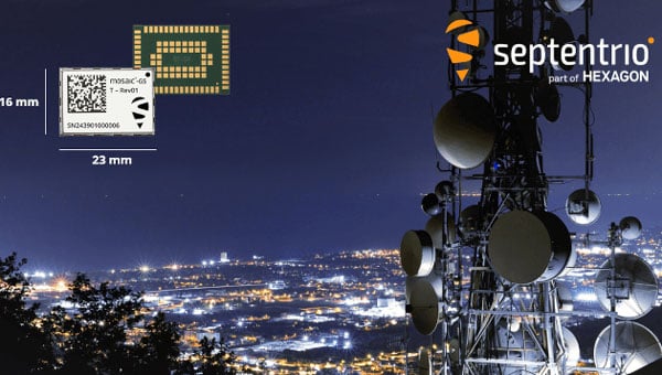
Septentrio, part of Hexagon, launched a miniaturized timing module designed to bring nanosecond-precision timing to high-volume applications requiring strict size and weight (SWaP) constraints.
The mosaic-G5 T measures 23 mm x 16 mm and weighs 2.2 g, making it suitable for data centers, telecommunications networks, satellite communications, financial institutions and other critical infrastructure requiring precise time synchronization.
The module receives signals from multiple GNSS satellite constellations and includes anti-jamming and anti-spoofing technology to maintain service continuity. It features built-in cybersecurity capabilities and dual pulse-per-second outputs for high-resolution timing.
“For over 25 years, we have been producing world-recognized timing receivers, serving critical applications and major industry players,” said Yasmine Hunter, product manager at Septentrio. “With our next-generation technology, we are now bringing precise and resilient time in an ultra-compact form factor to high-volume applications.”
The receiver operates across multiple frequencies, enabling high precision even in areas with radio interference. It supports clock and frequency input for synchronization and is ready to support Galileo High Accuracy Service. The module remains compatible with other correction services that enhance timing accuracy.
Artec 3D, a global 3D scanning lprovider, introduced its latest data capture and processing software, Artec Studio 20.
The all-in-one platform for 3D scanning, photogrammetry, reverse engineering and quality inspection now includes workflows that enable faster, fully automated data processing pipelines for digitization, design iteration and bulk product analysis.
The update includes enhancements across Artec’s scanner range. The Artec Spider II now features Live Scan Decimation, which produces high-detail, lightweight models for rapid prototyping and 3D modeling. The Artec Micro II adds support for HD Mode and 3-axis scanning, achieving higher resolution and more complete scans of small objects.
Refined masking in AI Photogrammetry produces ultra-realistic, artifact-free 3D models requiring minimal editing for computer-generated imagery, visual effects, forensics and other applications.
“Our last release turned Artec Studio into a complete package, with practically anything a user could need to capture a 3D model,” said Art Yukhin, CEO of Artec 3D. “Artec Studio 20 raises the bar in every way possible.”
Workflow automation
Users can customize workflows to their specific needs by queuing algorithms and processing captured data into 3D models with one click. The automation makes data processing up to 70% faster while allowing users to complete other tasks simultaneously.
Parameters can be adapted to different datasets within Artec Studio, but settings no longer need reconfiguration each time. Annual subscription holders can use scripting to set up workflows that import, process and export data to third-party software, enabling batch processing and fully autonomous file transfer.
Scanner upgrades
Artec Spider II now offers Real-time Fusion, previously exclusive to Artec Leo, which provides detailed live previews for reliable data capture. The newly integrated Autopilot streamlines the scanning process, particularly for new users. Improved reconstruction delivers more complete datasets for realistic, watertight models used in heritage preservation, education and medical applications.
The Artec Micro II desktop scanner now includes HD Mode, capturing four times more data points per scan. Three-axis integration provides greater surface coverage, allowing the scanner to capture complex, obscured areas and recreate complete objects.
The Artec Point industrial laser scanner features better visualization for twice-faster data capture. The wireless Artec Leo and long-range Artec Ray II benefit from a redesigned Fusion setting and workflow automation. Ray II users can now access Street View and panoramas through the updated app.
AI-powered photogrammetry
Refined masking in Artec Studio 20 produces realistic, artifact-free 3D models, while masking for texturing prevents objects from blurring with backgrounds.
Multi-camera support accelerates photogrammetry data capture and opens the software to various hardware combinations, including drones, smartphones, handycams and DSLR cameras. Sharp image prioritization ensures only the best frames from uploaded photos or videos are selected. GPU Memory Optimization customizes settings to individual hardware for peak efficiency.
Enhanced integration
New integration features make Artec Studio 20 more effective across applications. A new interface simplifies access to ZEISS Inspect advanced analysis tools and allows for scripting automation. Enhanced USD file support improves functionality for CGI and visual effects users. RCP file support adds compatibility with building information modeling platforms like Autodesk Revit.
Distance and intensity export filters optimize data for downstream processing. The software includes UI improvements with enhanced tools and scanning panels for more intuitive navigation and control.
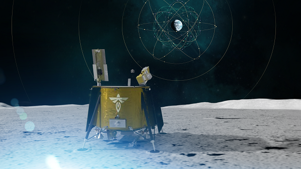
During a public workshop at the Italian Space Agency on Oct. 14-15, the Lunar GNSS Receiver Experiment (LuGRE) project team celebrated the closure of the project and released the data collected to the scientific community.
LuGRE, developed in partnership by NASA and the Italian Space Agency (ASI), flew to the Moon a GNSS receiver manufactured by the Italian company Qascom. The receiver was hosted aboard the Firefly BGM1 mission.
LuGRE demonstrated that signals from GNSS satellite constellations can also be used for positioning, navigation and timing (PNT) on the Moon.
The Navigation Signal Analysis and Simulation of the Dept. of Electroncis and Telecommunications of Polytechnic University of Turin processed the data received during the mission and contributed to all the science team activities, including the validation of the data and the processing of the initial set of scientific results.
An artist’s concept of the LuGRE payload on Blue Ghost and its three main records in transit to the Moon, in lunar orbit and on the Moon’s surface. (Image: NASA/Dave Ryan)
Launched on Firefly Aerospace’s Blue Ghost lander in January, LuGRE became the first payload to use Earth’s GNSS to calculate a navigation fix on the lunar surface and in lunar orbit. The experiment set a series of distance records on its journey to the Moon, demonstrating that GNSS technology can complement other navigation tools as far as 247,520 miles (398,350 km) from Earth.
These results point to a future where lunar astronauts, rovers and spacecraft can rely on the same satellite-based navigation systems we use every day to augment their navigation capabilities.
“It is a very important milestone for the satellite navigation community,” said Fabio Dovis, Politecnico di Torino, Italian Space Agency, of the project. “For the first time we have the recording of signal of the GPS and Galileo constellation collected in space and on the Moon surface. Already during the LuGRE mission we proved the feasibility of using satellite systems originally designed to be used on Earth up to lunar distances. Now the entire scientific community can use them to ‘re-play’ the space environment as well as analyze them in depth, for example, to retrieve information about the Earth atmosphere crossed by the signal themselves.”
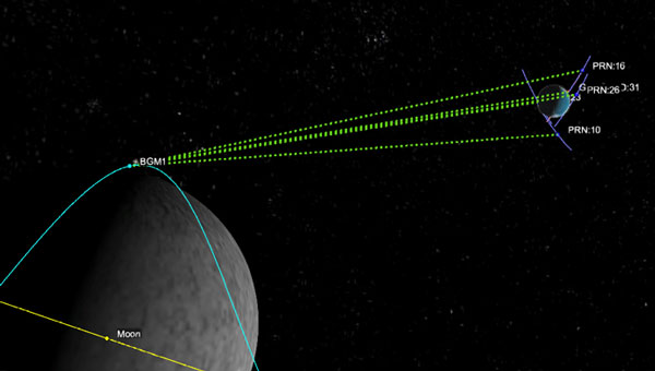
Artistic rendering of LuGRE and the GNSS constellations. In reality, the Earth-based GNSS constellations take up less than 10 degrees in the sky, as seen from the Moon. (Image: NASA/Dave Ryan)
The data release includes the actual GPS and Galileo radio signals LuGRE captured during its journey and on the lunar surface. The raw recordings — called in-phase and quadrature (I/Q) samples — allow researchers to analyze GNSS signal strength, noise and interference under lunar conditions for the first time. Engineers and scientists will use these results to model and refine the next generation of GNSS-based signal receivers and improve our understanding of how navigation signals operate at the Moon.
Graphic representation of the relative geometry of Earth-Moon-acquired GNSS satellites. (Image: Agenzia Sapaziale Italiana)
Iridium Communications is working with T-Mobile to on a broad network deployment of positioning, navigation and timing (PNT) services, starting with live-site activations across the United States. The deployments will deliver 5G network complementary timing synchronization to strengthen the cellular network’s resilience and help ensure reliability for customers.
The U.S. Department of Transportation CPNT Action Plan is designed to evaluate mature and commercially available CPNT technologies to strengthen PNT resilience and enhance the safety of critical infrastructure, like 5G networks. DOT is the U.S. government’s civil lead for PNT.
Under the contract, T-Mobile will expand its installation of Iridium PNT receivers to 90 additional live 5G network sites in geographically diverse locations. Iridium PNT will help protect against GPS disruptions that cause downtime and compromise the data integrity and performance of 5G networks, which rely on coordinated, precise timing to deliver the necessary speed, capacity and reliability of service to end-users.
T-Mobile will also perform nominal and adverse user equipment exercises at its indoor testing range. It has the necessary wireless infrastructure for DOT, Iridium, and T-Mobile to observe and record results.
Capable of sub-100-nanosecond accuracy — better than a millionth of a second — and secured using cryptographic techniques, Iridium PNT signals are 1,000 times stronger than GNSS systems like GPS and work inside buildings with no need for an outdoor antenna. The service is delivered by Iridium’s low-Earth orbit (LEO) satellite constellation, which provides global weather-resilient L-band connectivity.
MediaTek, China Telecom and Xiaomi have announced an upgrade to its real-time kinematic (RTK) high-precision positioning technology. The joint development integrates 5G connectivity, advanced chip design and Xiaomi’s smart technology.
RTK technology is usually found in professional surveying tools, but will now be available for location and positioning in smartphones, cars and city networks, according to the companies.
The newly upgraded RTK system enables outdoor positioning with sub-meter accuracy and fast response times. Leveraging 5G network infrastructure, smart data transmission, and close chipset-mobile software coordination, the system could be widely implemented on smart city infrastructure, autonomous driving, and smart transportation.
This partnership is part of Xiaomi’s growth beyond smartphones into urban development and smart mobility technologies under the Xiaomi HyperConnect banner.
The improved collaboration between MediaTek’s cutting-edge chipsets, China Telecom’s network, and Xiaomi’s hardware-software ecosystem enables an optimized RTK performance model that can potentially redefine how smart devices interact in real-world environments.
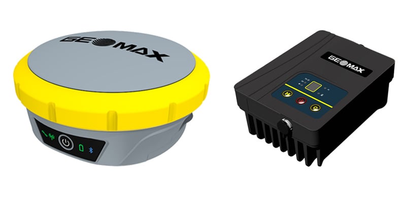
GeoMax has released its Zenith55 GNSS smart antenna and TRU35 high-power UHF radio for construction and surveying professionals.
The Zenith55 offers advanced features, efficient workflows that generate a strong return on investment, and warranty support.
Integrated into the GeoMax ecosystem, the Zenith55 works seamlessly with GeoMax robotic total stations, field controllers and the X-PAD field software for a comprehensive solution that ensures dependable precision and boosts productivity.
Zenith55 key features • Multi-frequency – Resilient to high solar activity • Multi-constellation – GPS, Glonass, Galileo, BeiDou, QZSS, NavIC • Calibration-free tilt compensation • GNSS board with 600+ channels • Integrated LTE phone modem and UHF radio modem • IP68 protection against dust and water • Withstands 2 m pole topple-over • Internal memory and microSD card storage • GeoMax X-PAD field software
The TRU35 is an IP67-rated 30W UHF radio modem with 410-470 MHz tuning range and 12.5/25 kHz channel spacing. Buttons and LCD display allow users to select predefined configurations created with the Zenith Manager tool for Android.
The TRU radio extends the UHF RTK range up to 14 km (in favorable conditions) and is compatible with GeoMax Zenith smart antennas with base station support.
TRU35 key features • 410 – 470 MHz frequency range • 10 / 30 W output power • 12.5 / 25 kHz channel spacing • Up to 19200 bps data rate • Protocols: Satel, TrimTalk • Modulation: GMSK, 4FSK • -30°C to +60°C operating temperature • IP67 dust and waterproof • Up to 14 km range (in favourable conditions)
The Zenith55 and the TRU35 are both available and ready for delivery.