TomTom and what3words will collaborate to bring what3words addressing to TomTom’s customers globally.
what3words addressing will roll out to TomTom consumer and automotive customers in the second half of 2018. TomTom made the announcement at TU Automotive Detroit.
what3words is a simple way to talk about location. The world is divided into a grid of 3 x 3-meter squares, and each square is assigned a unique three-word address. As such, what3words will complement TomTom’s existing maps, allowing people to accurately find any location and share it more quickly, easily and with less ambiguity than any other system.
The three-word address for TomTom’s head office, for example, can be found at ///pancake.climbing.beaker. The easy-to-use addressing system works well in areas where traditional maps and addressing don’t, including off-road locations and countries without standardized addressing systems such as India and the Middle East, the company said.
GPS World’s sister site, Geospatial Solutions, first discussed the innovation of what3words in 2015. It has since seen adoption by countries (such as Mongolia, Djibouti and Sint Maarten), and national mapping agencies of countries such as Norway and Switzerland. Sygic also adopted it for its fleet solutions.
“Whether you’re trying to find an address in the center of Turin, or on the streets of Tuvalu, TomTom wants to get you there quickly and efficiently,” said Antoine Saucier, managing director of TomTom Automotive. “Our collaboration with what3words demonstrates our commitment to embracing new addressing technology that is easy-to-use and integrates simply into our navigation offering.”
“We are delighted to partner with TomTom, and bring the benefits of more accurate addressing to their customers,” said Chris Sheldrick, CEO and co-founder of what3words. “By using what3words, drivers are able to navigate to any precise location — as specific as a side door, gate or parking spot. Equally, destinations that previously have been unaddressed now have a simple, reliable and easy-to-remember three-word address.”
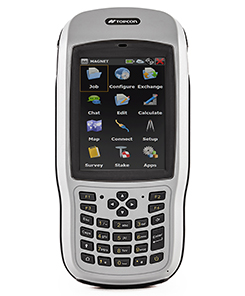
Topcon Positioning Group has introduced the T-18 handheld controller, which is designed to drive geopositioning, construction, mapping and vertical construction applications.
The controller includes a 3.7-inch sunlight-readable display with a 1-GHz processor, 1 GB of internal storage and up to 10 hours of battery life, the company said.
For data collection using Topcon’s MAGNET Field software, the T-18 controller offers a durable ergonomic solution with fast processing, a large screen, excellent connectivity and a long battery life.
Topcon MAGNET Field software offers a complete field solution for geopositioning professionals, enabling users to collect survey mapping data and perform construction and road layout using total stations, levels and GNSS receivers.
The T-18 features a 3.5G cellular modem for connectivity with Topcon MAGNET solutions for sending and receiving data to the cloud company account.
“The cellular option makes it easy to communicate with field crews when projects need to be changed or if important data is required back in the office. Additionally, the modem can be used for RTK (real-time kinematic) correction services,” Kerwin said.
Other key features include standard Bluetooth and Wi-Fi connectivity, as well as an IP65 rating for dust and water protection in demanding job site conditions.
The JNC, sponsored by the Military Division of the Institute of Navigation, will be held July 9-11 in a U.S. only, For Official Use Only (FOUO) environment at the Hyatt Regency Long Beach in Long Beach, California. The U.S.-only classified sessions will be held July 12 at The Aerospace Corporation.
According to ION, early registration can save $200 on conference registration fees by entering a reservation confirmation number from the Hyatt Regency Long Beach at the start of the registration process. Attendees will need a valid hotel confirmation number to claim the discount during registration.
Conference attendance for both FOUO U.S. only (July 9-11) and U.S.-only classified sessions (July 12) will be screened by the Joint Navigation Warfare Center and will be restricted to U.S. only.
Admission to the classified session will be limited to the capacity of the room and will be allocated on a first-come, first-served basis, to those who submitted visit requests in advance. Attendees requiring onsite security validation will be processed on a space-available basis. You are encouraged to submit your visit request early.
My last column described the National Geodetic Survey’s (NGS) GPS on Bench Marks (BM) 2018 interactive web map, and provided an update and status report on stations observed in support of the 2018 GPS on BMs Program. It mentioned that all new data received by the cut-off date of Aug. 31 will be analyzed by NGS and, if appropriate, the results will be included in the next hybrid geoid model. This is a great opportunity to provide data that will help to improve the hybrid geoid model in your region. This column will provide an update and status report on stations observed in support of the 2018 GPS on BMs program and provide an example of how OPUS-shared results identified a station that may have moved since it was last leveled.
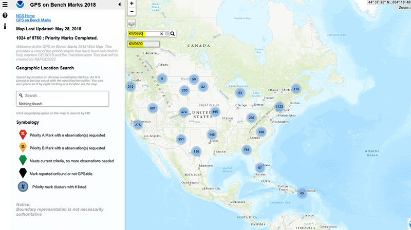
As mentioned in the last column, the GPS on BMs 2018 web page contains a link to a web map where users can determine which bench marks NGS would like users to occupy before the August 31, 2018, deadline. The web map also provides a list of the stations observed to date to ensure users are not wasting their time observing stations that already have enough repeat observations. NGS is updating the map weekly to reduce users occupying stations that already have enough redundant observations. The box titled “2018 Web Map” depicts the map update of May 25, 2018. The web map has a search feature so if the user knew a station’s PID, they could locate the station on the map. The box titled “An Example of Using the Web Map Search Feature” depicts the search feature using PID AW0690 (see highlighted section in the box).
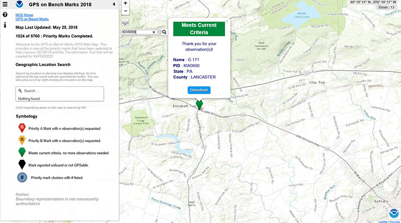
The box titled “Map After Searching for PID KW0690” depicts the map after searching for PID KW0690. As indicated by the symbol, the station meets the current criteria. That is, it has two GNSS-derived ellipsoid heights that agree within NGS’ criteria for use in evaluating and generating the next hybrid geoid model.
Map After Searching for PID KW0690
Click to enlarge.
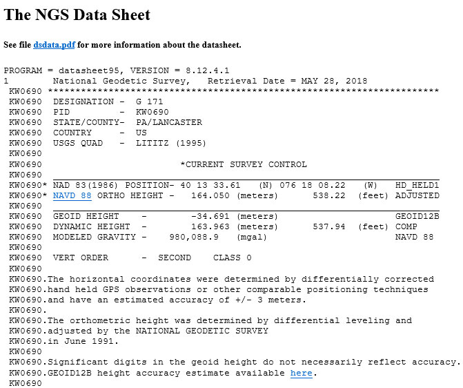
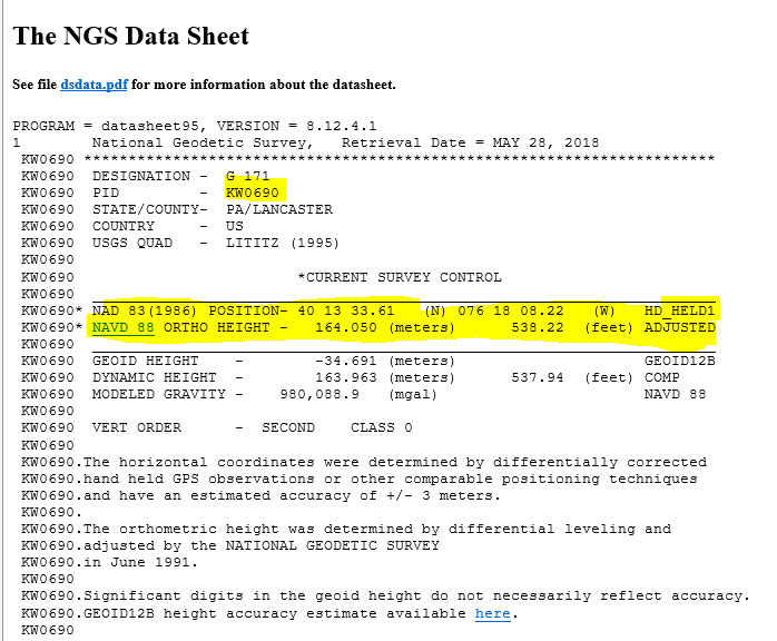
The user can continue to check on the link labeled “Datasheet” to obtain the latest data sheet for the station (see the box titled “NGS Data Sheet for KW0690”).
NGS Data Sheet for KW0690
Click to enlarge.
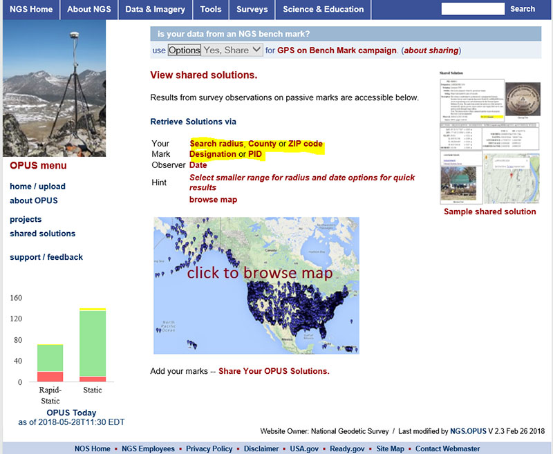
Next, let’s look at the OPUS shared results for the station (KW0690 – G 171). OPUS shared solutions can be found at this website. (see box tilted “OPUS Shared Solutions Web Page”).
OPUS Shared Solutions Web Page
Click to enlarge.
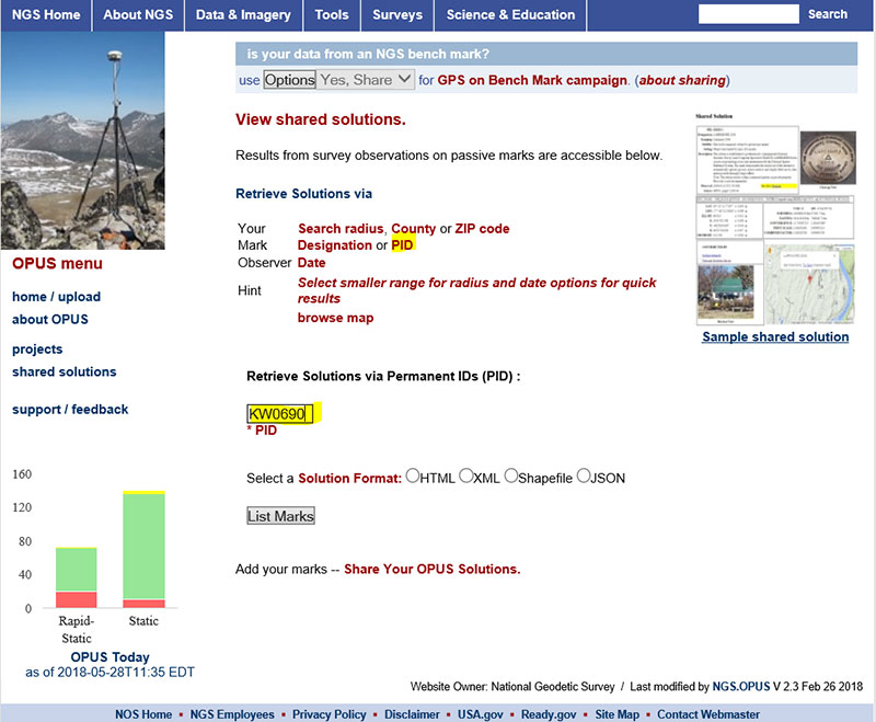
The user can search for a particular OPUS shared solution by checking on the PID option (see highlighted section on the box titled “Web Page After Clicking on PID Option.”
Web Page After Clicking on PID Option
Click to enlarge.
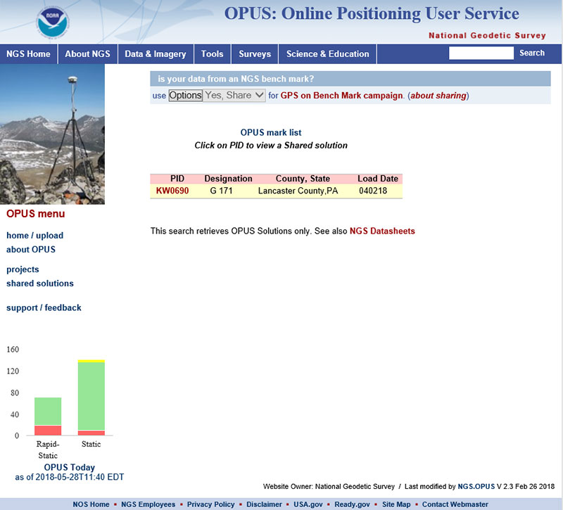
The box titled “An Example of Selecting an OPUS Shared Solution for a PID” depicts the output after clicking on the button labeled “List Marks.”
An Example of Selecting an OPUS Shared Solution for a PID
Click to enlarge.
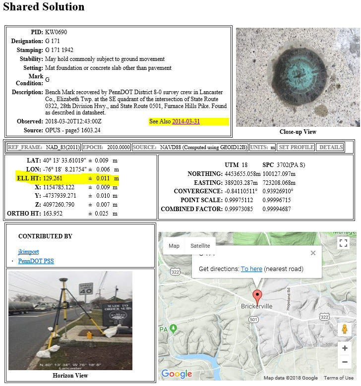
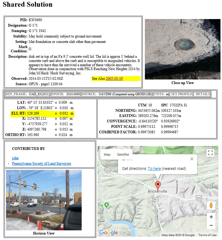
The box titled “The OPUS Shared Solution for KW0690 (2018-03-20)” provides the OPUS Shared solution for station KW0690 performed on March 20, 2018. The output provides the NAD 83 (2011) 2010.0 coordinates with error estimates.
The OPUS Shared Solution for KW0690 (2018-03-20)
Click to enlarge.
When there is more than one observation, the output file provides a link to the other observations. In this case, there was another shared solution on March 31, 2014 (see box titled “The OPUS Shared Solution for KW0690 (2014-03-31).”) The two solutions indicate the ellipsoid heights agree to 8 mm (129.269 m – 129.261 m). This is an indication that the station is a valid candidate to be considered for the development of the hybrid geoid model.
The OPUS Shared Solution for KW0690 (2014-03-31)
Click to enlarge.
The second OPUS Shared solution also indicates that there is a third observation (2005-03-19). Clicking on that link provides the NGS data sheet (see box titled “Excerpt from NGS Data Sheet for KW0690”).
Excerpt from NGS Data Sheet for KW0690
Click to enlarge.
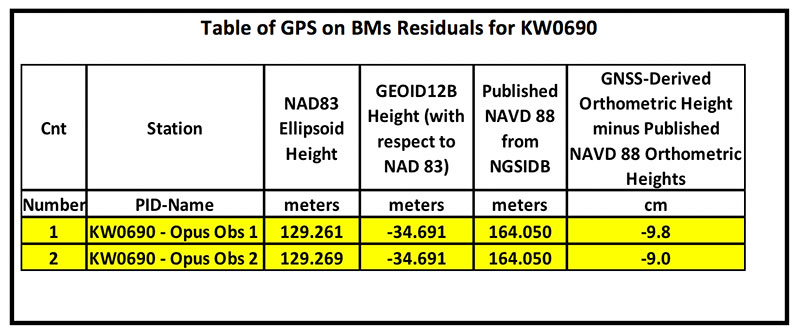
It should be noted that this station doesn’t have a published NAD 83 (2011) coordinate. The OPUS shared solutions provide the NAD 83 (2011) ellipsoid height and the NGS data sheet provides the published NAVD 88 orthometric height. Comparing the GNSS-derived orthometric height using the OPUS shared ellipsoid heights and GEOID12B indicate the station is inconsistent with published NAVD 88 orthometric height. The box titled “Table of GPS on BMs Residuals for KW0690” provides the GPS on BMs residuals based on using the latest hybrid geoid model GEOID12B. It was noted that the two ellipsoid heights agree to within 8 mm but the GNSS-derived orthometric heights using GEOID12B indicate that the two stations disagree with the published NAVD 88 height by almost 10 cm. This may be an indication that the station may have moved since the last time it was leveled. The question that needs to be addressed is should this station be used in the development of the next hybrid geoid model. In my mind, there are basically two school of thought on this topic. One, users that have used this individual station as control would like the hybrid geoid model to provide a GNSS-derived orthometric heights consistent with the published height of this station. If a surveyor followed the appropriate precise leveling procedures to check the validity of the station, that is, performed at least a two-mark leveling tie to ensure that the monument did not move, then they would want the model to be consistent with the published value. Two, if the station moved since it was last leveled, the hybrid geoid model would not provide the most accurate NAVD 88 height.
Table of GPS on BMs Residuals for KW0690
Click to enlarge.
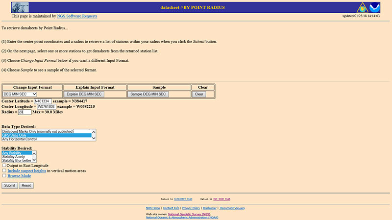
The next step is to analyze the GNSS-derived orthometric height using the latest experimental geoid model. Evaluating GPS on BMs stations nearby station KW0690 will help in determining if the station KW0690 has moved since the last time it was leveled. One way that users can determine stations nearby is to use NGS data sheet retrieval program using the option to retrieve stations by point radius. See box titled “Using NGS Data Sheet Point Radius Retrieval Option for KW0690.” The user enters a latitude and longitude value and a radius search in miles.
Using NGS Data Sheet Point Radius Retrieval Option for KW0690
Click to enlarge.
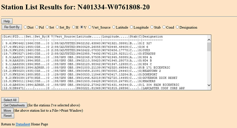
In this case, I entered the latitude and longitude of station KW0690, a radius of 20 miles (approximately 30 kilometers) and selected the option “GPS Stations Only.” The box titled “Output of NGS Data Sheet Point Radius Retrieval Option for KW0690” provides the output of the search. I sorted the stations by vertical control (“V”)
Output of NGS Data Sheet Point Radius Retrieval Option for KW0690
Click to enlarge.
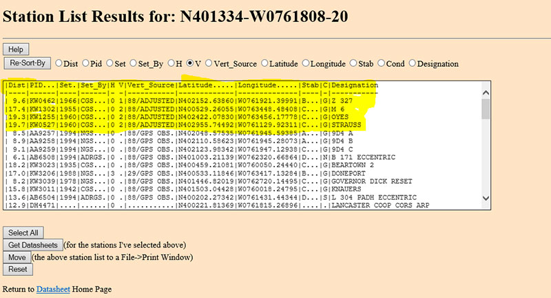
The four bench marks that also have GNSS-derived heights are highlighted in yellow in the box titled “Select the Bench Marks Based on NGS Data Sheet Point Radius Retrieval.” They are all within 20 miles (approximately 30 km) of the station KW0690. By analyzing the GPS on BMs residuals of these nearby stations we can determine if station KW0690 is consistent with its neighbors.
Select the Bench Marks Based on NGS Data Sheet Point Radius Retrieval
Click to enlarge.
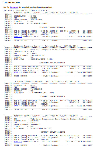
I retrieved the data sheets so I could get their published coordinates for the xGeoid17 web tool. See box titled “Excerpts from Data Sheets Based on NGS Data Sheet Point Radius Retrieval” for the data sheets.
Excerpts from Data Sheets Based on NGS Data Sheet Point Radius Retrieval
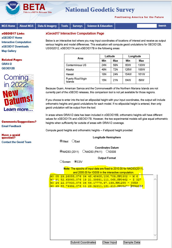
Once you have the stations that are located near the station you’re interested in you can proceed to the xGeoid17 website to obtain the latest information based on the scientific geoid model. I described this procedure in a previous column. See box titled “Using the xGeoid17 Web tool for Stations Nearby KW0690” for an example of the input to the tool.
Using the xGeoid17 Web tool for Stations Nearby KW0690
Click to enlarge.
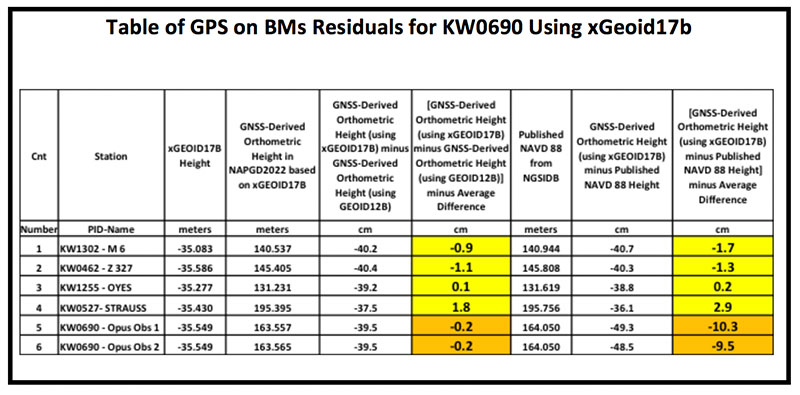
The table titled “Table of GPS on BMs Residuals for KW0690 Using xGeoid17b” provides a summary of the results from the xGeoid17 web page. The procedure used to compute the GPS on BMs residuals has been described in a previous column.
Table of GPS on BMs Residuals for KW0690 Using xGeoid17b
Click to enlarge.
Looking at the column labeled “[GNSS-Derived Orthometric Height (using xGEOID17B) minus Published NAVD 88 Height] minus Average Difference” indicate that the large difference that we noticed using GEOID12B at station KW0690 is also seen using the latest experimental geoid model xGeoid17b. Once again, this is an indication that the station may have moved since it was last leveled.
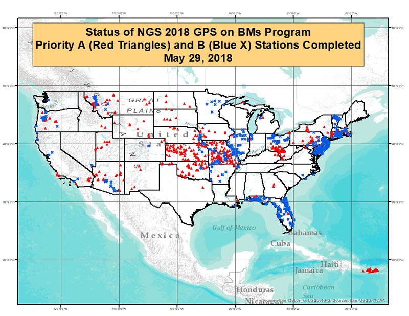
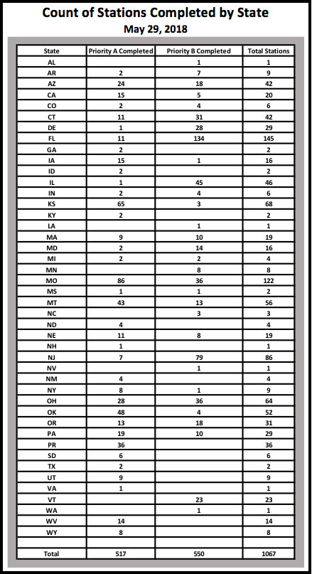
As of May 29, 2018, 1067 of the 5760 priority marks were completed. The box title “Status of NGS 2018 GPS on BMs Program as of May 29, 2018“ is a plot the stations that are labeled as completed and the box titled “Count of Stations Completed by State “ provides the number of stations completed by state. The red triangles are priority A stations completed and the blue “X” are priority B stations labeled as completed.
Status of NGS 2018 GPS on BMs Program as of May 29, 2018
Click to enlarge.
Count of Stations Completed by State May 29, 2018
The number of stations completed as of May 29, 2018, represents about 18.5 percent of the total number of stations that need to be observed. August 31, 2018, is only two months away. According to my latest search of the NGS website (June 3, 2018), 1098 stations are considered done. Hopefully, the number of completed stations will significantly increase during the next last two months. As I have explained in previous columns, there are many invalid GPS on BMs stations that may be used in the next hybrid geoid model unless more bench marks with valid NAVD 88 heights are observed with GNSS. This column provided an update and status report on stations observed in support of the 2018 GPS on BMs program and provided an example of how the OPUS Shared results as identified a station that may have moved since it was last leveled. This is your opportunity to help develop a current, valid hybrid geoid model in your area, and identify NAVD 88 bench marks that have moved since they were last leveled.
Victoria, Australia, is seeking to upgrade its digital cadastre, and is seeking industry interest. The Department of Environment, Land, Water and Planning (DELWP) has issued a market notification for industry on Digital Cadastre Modernisation (DCM).
DELWP has two related procurement processes in May and July 2018.
Request for Tender (RFT) 338298 for cadastral data back capture services was issued by DELWP on May 28, 2018.
A related Expression of Interest (EOI) will be released for the remaining stages of the DCM, (adjustment, integration and automation phases) on or about July 31. Potential suppliers will be asked to register their interest and outline their capability to deliver and innovate across one or multiple stages. Further procurement steps are anticipated in 2019.
Four inter-related stages of the DCM are expected to go to market. The tender notice described here relates to the first stage – back capture (RFT process 338298).
DELWP is upgrading the spatial accuracy of the state’s digital representation of property boundaries (the authoritative digital cadastre) for the state’s 3.3 million properties. An upgraded digital cadastre will deliver significant quality and efficiency improvements for sectors including land development, surveying, planning, utilities, emergency services and infrastructure development. The DCM will deliver spatial accuracy of up to 0.1 metre for urban and 0.5 metres for rural land.
STAGE 1 – Back capture: This stage will accurately capture specified data from PDF copies of registered plans and cadastral surveys into digital format LandXML files. This stage will also include the capture of particular features from aerial imagery.
The tender will seek proposals to deliver back-capture services for the entire state. Key information relating to the tender includes:
The scope should be broken into a minimum of three packages (a maximum of 1.3m parcels in any package), and the initial contract will be for only the first package.
Bidders should scope these packages in a manner which they believe will best meet DELWP’s objectives (around the most accurate and efficient delivery of the upgraded digital cadastre).
Subject to satisfactory delivery of the first contract, the successful bidder may be contracted to deliver the remaining packages.
Alternate proposals are encouraged, should bidders identify an opportunity to deliver better outcomes or innovation by combining the back capture stage with another DCM stage (outlined below).
Future procurement / future DCM stages (June EOI)
Three future stages of the DCM which will be outlined in the July EOI are briefly described below.
STAGE 2 – Adjustment: Initially, the analysis and validation of the back captured data obtained from stage 1 will be required. This will be followed by calculation and validation of the coordinates and uncertainties for all land parcel corners from back captured files and Victoria’s Survey Control Network. DELWP has bespoke software that may assist with the adjustment process, which can be licensed free of charge to the service provider.
STAGE 3 – Integration: Integrating the upgraded digital cadastre from STAGE 2 into the state’s authoritative map base (Vicmap). Note that the DCM upgrade coincides with the next re-tender of the ongoing maintenance contract for Vicmap, and it is possible there will be an opportunity for vendors to bid for both the integration stage and ongoing maintenance.
STAGE 4 – Automation: Enhancing DELWP’s existing corporate systems to fully automate the process of updating Victoria’s digital cadastre with new data (such as new sub-divisions) lodged in a digital format through SPEAR.
A fifth and essential aspect of the project relates to change management; this will run throughout delivery.
For more information contact [email protected], DCM program manager.
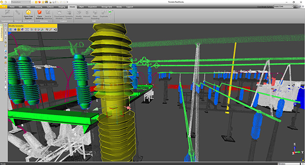
Trimble will release a new version of Trimble RealWorks, its all-in-one point-cloud software platform. The new version of Trimble RealWorks — featuring performance and user interface (UI) improvements — will be available for download June 19.
Changes include the following:
Batch processing workflows are now available to automate data processing for large datasets saving users time on projects.
New visualization and productivity tools include enhanced shading, improved registration automation and geometry editing. According to Trimble, the new tools enable customers to better understand project data and more easily create customer deliverables.
Enhanced multi-core processing for modern CPUs and added support for AMD Ryzen-based computers significantly reduces the processing time for registering and extracting scans.
Esri’s ArcGIS software is being integrated into SAP’s latest cloud-based offering, SAP HANA spatial services, to help customers create location-aware business applications faster, according to spatial analytics company Esri.
Based on SAP Cloud Platform, the new offering enables businesses to process location data such as complex imagery, as well as visualize and analyze their authoritative data in a geospatial context.
The new geo-enabled solution from SAP will allow users to deliver their data through consumer-friendly maps and integrate the results into custom business applications, the company said. Customers using SAP software will also be able to create custom models that efficiently process streams of Earth observation data such as water content or soil temperatures and see this data on high-quality basemaps provided by Esri’s ArcGIS Online.
Most business objectives — such as increasing revenue growth, reducing operational costs or improving customer service — rely on some sort of location data. Unfortunately, many executives lack an accurate and up-to-date understanding of where performance is going well and where improvements need to be made.
This new offering from SAP, which leverages Esri technology, lets organizations extract high-value business information from satellite, drone and open data sources and then easily discover and share location-based insights.
“As an SAP global technology partner, we are very excited about this offering, as it demonstrates that SAP and Esri products work better together,” said Chris Cappelli, director of strategic business development at Esri. “Users of SAP HANA spatial services can now achieve native integration of spatial and enterprise data across all business processes. By putting the power of location information into the hands of key stakeholders, businesses can make better-informed decisions with their own data.”
The integration follows SAP’s announcement on Jan. 24 that Esri supports SAP HANA as an enterprise geodatabase with the release of ArcGIS 10.6 and ArcGIS Pro 2.1.
Esri and SAP customers can benefit from enhanced performance and scalability as well as full integration of both enterprise and spatial data. Both Esri and SAP continue to deliver new innovations that help lower total cost of ownership and administration costs brought on by the tight integration of IT and geospatial landscapes, Esri said.
Esri will showcase its new integration of location intelligence technology with SAP HANA spatial services at SAPPHIRE NOW and ASUG Annual Conference in booth #1239.
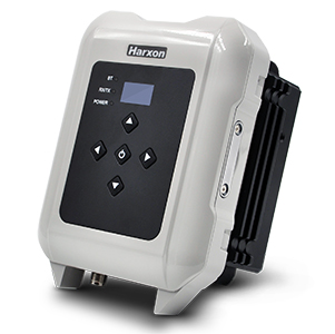
Harxon has introduced the smart eRadio, a member of its radio modem series. The eRadio is a long-range and power-efficient solution designed to support high-precision GNSS real-time kinematic (RTK) applications in surveying and precision agriculture.
Harxon eRadio is enabled with intelligent serial baud rate identification for different RTK devices. It can automatically identify RTK serial baud rate with a radio data cable and provide a plug-and-play form for easy connection between the eRadio and RTK, the company said.
Photo: Harxon
Due to its high transmitting power (5-35 Watts), transmission data can be up to 19200 bps/s over a connection distance of 50-80 kilometers, depending on the environment.
The eRadio offers surveyors an easy-to-use radio modem that provides dependable performance as either a base or repeater working with other Harxon radio modems in challenging environments. In the store and forward operating mode, eRadio receives messages, buffers the received data and transmits further to another substation.
The user programmable eRadio also supports the Bluetooth of APP to configure data and update radio status. Its diagnostic reporting software can realize the built-in reliability monitoring, such as internal temperature, environment status and battery level and channel inspection. According to the company, these features allow users to both anticipate and deal with potential issues efficiently.
In addition to compatibility with radio protocols by Trimble and Satel, eRadio is equipped with its unique ETALK communication protocol, which uses Harxon’s exclusive algorithms and advanced processors. Under the same conditions, ETALK protocol can significantly reduce the bit error rate of weak signals and the communication distance can be increased by 20 percent.
The compact, rugged eRadio is particularly well suited for heavy-duty outdoor use. It is designed for easy mobile use with an organic light-emitting diode display screen for demanding field conditions. The IP67 full metal cover provides dust and water resistance that keeps surveyors working with confidence and efficiency.
SXblue, also known as Geneq, has introduced its SXblue ToolBox, an Android application for SXblue GNSS receivers.
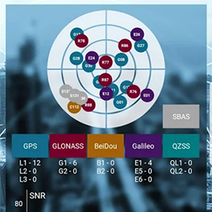
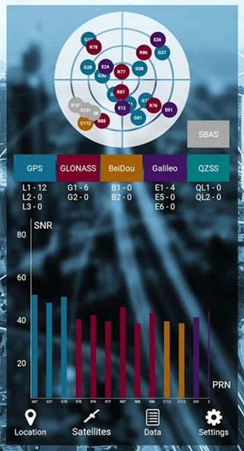
Using the SXblue ToolBox, receiver users can view and analyze the position data provided by the SXblue receiver and metadata related to its location. The user can send commands that enable or disable some features, including systems in use, mask angle or differential angle, and constellation in use, including GPS, GLONASS, Galileo, BeiDou and SBAS.
The SXblue ToolBox is also an NTRIP client capable of connecting to a NTRIP server for real-time kinematic (RTK) corrections and thus allow the receiver to issue very accurate location information. The application is able to record, save and transfer the raw data from the GNSS receiver, allowing post-processing activities on computers for surveying and geomatics professionals.
The application has been developed with special consideration for modern mobile device development and attention to user and dealer feedback, the company said.
The application includes a series of audible and visual alarms configurable by the user to determine the thresholds of the information provided by the SXblue GNSS receiver.
Main features of the SXblue ToolBox include:
Display of location information and quality of the position data
Skyplot of all-in-view constellations: GPS, GLONASS, Galileo, BeiDou, QZSS, SBAS
Log raw data
NTRIP/DIP client for receiving RTK corrections
Terminal to send commands and view the output data of the SXblue device
Audible and visual alarms
Activation of options and licenses via the application.
Founded in 2010, U.S.-based AutonomouStuff is developing turnkey platforms for autonomous vehicle development, robotics and data intelligence innovation. Its turnkey platforms are deployed in pilot programs worldwide representing more than 2,500 customers in the automotive and technology sectors across Silicon Valley, America, Europe and Asia.
“The acquisition of AutonomouStuff accelerates Hexagon’s ability to move our customers beyond the data impasse of IoT [internet of things],” said Ola Rollén, Hexagon President and CEO. “We’re particularly interested in technologies that are the most disruptive — those capable of leveraging the vast potential of data being generated by connected things, integrating AI [artificial intelligence], edge-cloud orchestration, mobility and data visualization into autonomous connected ecosystems. When combined with our positioning intelligence, mapping and sensing technology leadership, this acquisition creates a nexus of domain expertise that will lead the autonomous mobility industry for years to come.”
AutonomouStuff began when CEO Bobby Hambrick realized that robotics company representatives were having difficulty gaining access to the technology needed to solve their applications, according to the company. He envisioned a place where they could find the products needed to get their projects up and running. It is headquartered in Morton, Illinois, with offices in San Francisco, Detroit, Germany and China.
AutonomouStuff has been closely involved in Project Apollo, an autonomous driving ecosystem helmed by Baidu, the so-called “Google of China.”
Project Apollo seeks to provide an open, comprehensive and reliable software platform for Baidu’s partners in the automotive and autonomous driving industries. Partners can use the Apollo open software platform together with the reference hardware platform to accelerate development of their customized autonomous vehicle solutions.
AutonomouStuff provides the Apollo Kit to project partners: the hardware, software and services required to begin developing their own autonomous vehicle. NovAtel SPAN GNSS/INS products provide position, orientation and time as a critical component of this kit. A detailed description of the NovAtel (another Hexagon company in the Positioning Intelligence Group) and AutonomouStuff partnership is given in the August 2017 cover story of GPS World, “Autonomy assembled: Driverless kits to hit the road in 2020.”
At a Baidu conference in Beijing, April 2017, AutonomouStuff kitted out two standard Lincoln MKZ sedans for demonstration drives, with one technician completing each vehicle in about three hours — a task that would normally take a team of workers up to six weeks. The two Lincolns then drove simultaneously, driverless, around a test track.
The technology has been developed to be transferrable to other vehicles. Each car is modified by adding lasers, camera, radar sensors, GPS and inertial measurement unit (IMU), a drive-by-wire computer interface and computer engine.
As of August 2017, the kit incorporated a choice, depending on user needs, of a selection of NovAtel GNSS receivers, including the ProPak6 GNSS receiver and the SPAN-IGM-A1 GNSS+IMU combined system, IMUs such as the IMU-ISA-100C incorporating Northrop-Grumman Litef GMBH’s inertial measurement technology, and antennas such as the GNSS-703-GGG-HV high vibration triple-frequency GPS, GLONASS, BeiDou and Galileo antenna. A 64-beam Velodyne lidar sensor and 16-beam HDL-16E provide laser data. Some units may have changed since then.
Terry Lamprecht, director of products at AutonomouStuff, gave a presentation on verifying proper installation, and creating a baseline data set to benchmark against data collected on autonomous vehicles in real-time, as part of a November 2017 GPS World webinar, “High Accuracy for Autonomous Driving.” Download the free webinar here.
Completion of the transaction is subject to regulatory approvals, including a voluntary filing to the Committee on Foreign Investment in the United States, and other customary conditions that are expected to be satisfied within the next 90 days.
A: Satellite-based and local beacon-based positioning technologies offer the best opportunity for reliable and precise location determination of an autonomous vehicle. Alternate solutions like SLAM and lane keeping are decent augmentations, but suffer from the imprecision that comes from sensing in a large dynamic environment. As satellite and local beacon-based positioning technologies become increasingly more pervasive and accurate, this will continue to yield the most reliable and deterministic solution for safe localization of autonomous vehicles.
A: No matter how good it gets, positioning technology can never ensure the safety of autonomous car passengers and pedestrians. Knowing the position of each car is insufficient; you need to know where everything else is, including children, animals and temporary construction barriers. It is simply not practical to fit everyone and everything with a positioning device that transmits to every nearby vehicle. Collision avoidance therefore needs sensors such as radar and lidar.
A: Realization of safe autonomy requires the establishment of layers of protection using safety mechanisms without dependent faults. Absolute position provided by precise GNSS and inertial technology provides an independent reference for truth test of positioning solutions obtained with vision-based technologies. Vision-based solutions may incorporate common cause faults like sight obstruction, processing algorithms or similar. Absolute positioning can also contribute to realize near-real-time updated maps.
The University of Nottingham is working with Brazilian and European Union (EU) partners to solve atmospheric interference problems that hamper satellite-based positioning in equatorial countries like Brazil.
The research network will support the advancement of precision agriculture, which aims to make crop farming practices cheaper, greener and more efficient using satellite positioning and remote sensing.
These technologies rely on GNSS (such as GPS and Galileo) to obtain centimeter-accurate coordinates on Earth. Farmers then use this real-time precise data to optimize fertilizer use, to steer driverless machinery and for soil mapping to maximize crop production in a bid to feed a rising world population.
Despite its revolutionary potential, precision agriculture adoption rates in countries on equatorial regions such as Brazil are hindered by ionospheric scintillation in the Earth’s upper atmosphere.
Ionospheric scintillation affects the integrity, availability and accuracy of satellite positioning. Specifically, it causes interference with the propagation of satellite signals as they pass through the ionosphere, making it difficult for GNSS receivers to lock onto satellites and track their signals. This results in not only large errors but sometimes to service outages.
“The strong signal fluctuations that characterize ionospheric scintillation are caused by the irregular behavior of the ionosphere that is typical of the equatorial latitudes, affecting most of the Brazilian territory, hence the importance of the bilateral collaboration in the PEARL network,” said project leader Marcio Aquino from the Nottingham Geospatial Institute at the University.
The PEARL network, which is funded by the European Commission’s INCOBRA project, aims to tackle this problem head on to ensure high-accuracy positioning by satellite is robust and achievable in real time in Brazil.
“Solutions arising from the research will have a positive impact not only in Brazil but in the whole of Latin America, due to its geographical location near the equator and corresponding disruptive ionospheric effects,” Aquino said. “It could play a pivotal role in promoting the uptake of satellite-based positioning and the broad acceptance of the new EU system Galileo, paving the way for service implementation in other similarly affected parts of the world, such as southern China, India, Indonesia and Malaysia.”
Research and industrial partners from both Europe and Brazil will come together on the seven-month initiative to develop strategies to map the causes of ionospheric scintillation and specialized algorithms to model and mitigate their effects on satellite-based positioning.
These strategies will be part of a large Brazil-EU collaborative proposal to be submitted to the forthcoming H2020 SPACE-EGNSS call due out in October 2018.
Network members include small to medium enterprises in Europe and Brazil that are keen to incorporate new solutions that will improve their satellite-based services.
The PEARL network encompasses:
University of Nottingham, UK; Sao Paulo State University and Universidade do Estado de Mato Grosso, Brazil.
National Institute of Geophysics and Volcanology and SpacEarth Technology (an SME), Italy.
Space Research Centre of Polish Academy of Sciences, Poland.
Three small and medium-sized enterprises (SMEs): Geo++, Germany, and Alezi Teodolini and MC Engenharia Ltd, Brazil.
The European Commission funds the INCOBRA project to increase and enhance Research and Innovation cooperation activities between Brazil and the European Union. PEARL is one of INCOBRA’s bilateral R&I cooperation networks, led by the University of Nottingham, addressing one of INCOBRA’s priority areas, namely bio-economy, food security and sustainable agriculture.
According to the latest issue of the GSA GNSS market report (issue 5, 2017), revenue for GNSS device sales in precision agriculture will grow to nearly €3 billion by 2025, quadrupling from €750 million in 2013 (based on GNSS receiver sales to just this market segment).