Category: Applications

  • Esri releases Sentinel-2 Image Services through Living Atlas

    Esri is releasing Sentinel-2 Image Services to all Esri users for no additional cost.

    According to the company, Sentinel-2 is an Earth Observation Satellite that provides multi-spectral imagery for any location in the world at 10-meter resolution. Currently in beta, the service is updated daily with new imagery for all ground locations every five to seven days.

    The Sentinel-2 Image Services provide temporal, multi-spectral imagery of the entire globe for improved monitoring of agricultural and forest conditions, monitoring of land cover changes, and to assist with natural disaster management.

    Sentinel-2 is part of Copernicus, the world’s largest single Earth observation program directed by the European Commission in partnership with the European Space Agency.

    Esri makes the multi-spectral data quickly accessible using ArcGIS Image Server and publishes an image service through the ArcGIS Living Atlas of the World, hosted on the Amazon Web Services Infrastructure.

    The service includes all Sentinel-2 imagery going back 14 months, enabling change to be easily reviewed. Image analysis can be run directly on the service to create indexes displaying properties such as vegetation health or soil moisture as well as quantifying the changes over time, for better understanding of the environment.

    “We are committed to helping our users discover, explore, and better understand our changing planet,” said Jack Dangermond, Esri founder and president. “Pairing Sentinel-2 imagery with our ArcGIS Image Server provides a powerful platform for in-depth analysis which can inform meaningful action.”

    Sentinel-2 multi-spectral imagery can provide better visualization and understanding of catastrophic events such as Hawaii’s Kilauea volcano, the company said. The ability to use imagery of the volcano along with other spatial data, such as digital elevation models, provides an unprecedented opportunity to help predict lava flow direction and provide advanced notice to those who may be in danger.

    Sentinel-2 can also help provide understanding of the conditions that lead to fires such as this past winter’s Thomas Fire, which is California’s largest wildfire on record. The Thomas Fire burned more than 280,000 acres and triggered massive mudslides. Visualizing factors, such as periods of increased moisture contributing to more lush vegetation followed by hot and dry weather, can help predict future wildfires and mitigate their effects in the future.

    The Sentinel-2 imagery is available through the Living Atlas, the foremost collection of geographic information from around the globe. The Living Atlas is included with all ArcGIS online subscriptions. It is comprised of maps, apps, and data layers that support the work of thousands of Esri users around the world. Full service access, including a rolling 14-month archive of the Sentinel-2 data, is now available to all Esri ArcGIS users.

  • TerraGo launches reconnaissance app in NGA GEOINT store

    TerraGo launches reconnaissance app in NGA GEOINT store

    Image: TerraGo
    Image: TerraGo

    TerraGo, a provider of dissemination and collaboration software for defense and intelligence agencies, has announced the availability of R3 for immediate download in the National Geospatial-Intelligence Agency’s (NGA) GEOINT App Store.

    R3 is a mobile data collection and collaboration app customized for the missions of reconnaissance, response and recovery. Designed for the most challenging missions and environments, R3 lets users keep working offline and off the grid with customizable workflows for security, humanitarian and disaster relief programs, the company said.

    “R3 enhances situational awareness, search and rescue, damage assessments and recovery efforts,” said Scott Lee, director of federal programs at TerraGo. “It really gives users the best of both worlds with mobile technology that can go anywhere, and will also work even when the network doesn’t.”

    Image: TerraGo
    Image: TerraGo

    Designed with a simplified user interface, R3 provides a robust standalone capability for a variety of field-based collection activities. Users can access custom basemaps from numerous GIS, map and imagery sources including GeoPDF, ArcGIS, USGS and GXP, while collecting and exchanging location-tagged notes using smart forms, photos, videos and audio files.

    Pre-loaded forms are available for structured assessments, and users can connect to a secure server to create unique mission packages and enable synchronous collaboration. R3 supports important standards like OGC GeoPackage interoperability and sharing geospatial assets among mission partners.

    Registered GEOINT App Store users can download TerraGo R3 for iOS here. The Android version is complete and coming soon, the company added.

  • Hexagon’s new PIM7500 GNSS receiver chosen for autonomous buses

    The Hexagon PIM7500 GNSS receiver.

    Hexagon’s Positioning Intelligence division has released the PIM7500 GNSS receiver explicitly designed for autonomous automotive platform development and solutions.

    The single-sided receiver features a compact form factor that solders down directly for easy integration with electronic control modules and artificial intelligence (AI) development platforms, the company said.

    The new receiver features dual-frequency GNSS reception from all available constellations including GPS, GLONASS, Galileo, BeiDou, NavIC, QZSS and SBAS. It offers sub-meter and centimeter-level positioning using Hexagon Correction Services to deliver the high-accuracy positioning required for the autonomous industry.

    The PIM7500 is available in low to mid-volume quantities, making it a suitable GNSS receiver for mileage accumulation fleets.

    “Hexagon Positioning Intelligence has a strong commitment to the automotive market and will utilize its leadership in GNSS-based technology to provide high precision and safe positioning systems to the automotive market — now and in the future,” said Andreas Niemann, business development manager at Hexagon Positioning Intelligence.

    PIM7500 chosen for autonomous buses

    Autonomous commuter buses are being developed by Bertrandt, with the PIM7600 GNSS receiver. The test system will be installed on a bus in Regensburg, Germany. (Photo: Patrick Reinig)

    Bertrandt, a European company that specializes in automotive controls technology development, has selected the PIM7500 receiver as the precise positioning component on its innovation platform.

    Bertrandt’s innovation platform uses the PIM7500 receiver and inertial measurement unit (IMU) from Hexagon Positioning Intelligence, combined with lidar sensors, to perform image processing for object detection, collect precise route data and generate highly accurate maps.

    The innovation platform will be implemented on one of the public transportation electric busses in Regensburg, Germany.

    “We are pleased to have Hexagon Positioning Intelligence onboard our innovation platform for this project,” said Ulrich Haboeck, team leader of electronics and software development at Bertrandt. “Hexagon Positioning Intelligence is the perfect fit to provide the GNSS sensor components for the platform because their technology will ensure the success of the project.”

    Bertrandt announced the innovation platform on May 16. Hexagon Positioning Intelligence will be participating in Bertrandt’s TechDays Sept. 27-28 to demonstrate automotive and safety-critical GNSS and inertial solutions.

    “Bertrandt is an ideal technology partner for us, and we are excited to be invited to have the PIM7500 as a component on their innovation platform,” Niemann said.

  • Hexagon Positioning Intelligence attains milestone for safe autonomous driving

    Hexagon’s Positioning Intelligence division has achieved a milestone toward its goal of safe autonomy on the road. The division is developing functionally safe positioning technologies for fully autonomous vehicles and other applications.

    A third-party audit has been completed that confirms process compliance with key automotive specifications ISO/TS 16949 and ISO 26262 Functional Safety Design Assurance. This is an important step toward the development of functionally safe new technology that meets the exceptional safety standards set by the automotive industry, Hexagon said.

    “We’re thrilled to have our core engineering processes updated to meet the requirements of automotive applications,” said Jonathan Auld, vice president of Safety Critical Systems, Hexagon’s Positioning Intelligence division. “We are building on a 25+ year history in safety of life solutions for the marine and aviation industries, and we expect this leadership to serve us well in automotive.”

  • Driver safety highlighted in new GPS tracking solution for fleets

    Teletrac Navman, a global software-as-a-service provider that leverages location-based technology for GPS tracking solutions, has launched its fully integrated Driver Safety Analytics Solution.

    Part of the Teletrac Navman Director platform, the safety analytics solution combines GPS tracking data and event replays, dashboard camera technology, driver scorecards and analytics on a single platform so fleet managers have all the information needed to reduce risks and implement safe driving practices across their fleets, the company said.

    “I have a full view into safety and the solution makes everything fact-based. Before I had perceptions of how my drivers behave on the road, but now I have proof,” said customer Bonnie Lantz, director at P&B Transportation. “I can see training needs and, of equal importance, our drivers’ incredible defensive driving when cars around them behave erratically. Our insurance company and drivers both wanted the cameras, and I expect it will save us money and give our whole fleet a better grasp on safety.”

    The Director Safety Analytics module provides insight into driver-specific and fleet-wide behavior to create a safety-focused culture, recognize and retain great drivers, and improve the insurance claims process. Features include:

    • The Integrated Event Viewer lets fleets simultaneously view driving event replays and unsafe behaviors on Google Maps, using GPS tracking data, and second-by-second Dashboard Camera video footage for quick response to and resolution of incidents.
    • Front-Facing Dashboard Cameras continuously record HD quality video footage, with recordings of all events stored in the cloud. In addition to getting a complete picture of events, footage can be used as supporting material in the event of an insurance claim and to protect against driver fault in accidents.
    • Driver Scorecards track and rank driver improvements over time for personalized training, in combination with event replay and live footage, and to recognize positive driver behaviors.
    • Reporting & Alerts measures speeding, harsh breaking, erratic cornering and other dangerous behaviors through GPS tracking and proactively alerts fleet managers. It lets fleet managers build dashboards around safety KPIs and do in-depth evaluation on fleet-wide and individual driver safety performance to easily communicate performance trends, create targeted improvement plans and build incentive programs that encourage safe driving.

    “We built this solution to give fleets absolutely everything they need to build a culture of safety,” said Daren Lauda, general manager of North America, Teletrac Navman. “The high-level fleet benchmarking is easy to drill down into to understand how individual drivers are performing. Add in the integrated telematics and corresponding video footage and fleet managers have a complete, real-life picture of safety to fuel individualized training, track progress and protect their drivers in incidents.”

  • Auto-scanning total stations working on China’s expressways

    Spectra Precision‘s Focus 35 robotic total stations are helping build the world’s largest expressway network. For instance, the Focus 35, with its time-saving automatic scan template, is checking the cross-section quality of the twin Nan Kunshan tunnels for the new six-lane Shazhan S14 regional highway.

    Excavation under Nankun Mountain for the twin tunnels, each 4.1 kilometers (km) long and each capable of carrying three lanes of vehicular traffic, began in September 2016.

    In the current second phase of construction, the Focus 35 is being used to gather data that will be used to compare the as-built tunnels to the design specifications to determine what adjustments to the tunnel surfaces may need to be made.

    The Focus 35 was selected for the scanning work because it offers a streamlined and efficient workflow that yields significant time-savings, the company said. The workflow of a conventional total station requires time-consuming manual scanning followed by export to a separate post-processing function after which a DXF file is generated.

    The Focus 35, with its Trimble Access Tunnel software, saves significant time because it automatically scans and directly generates DXF reports for submission to the contractor to check over-break and under-break values, the company said.

    When completed, the new six-lane 800-km Shazhan highway will connect Shantou and Zhanjiang, two important coastal cities in southern Guangdong province. The contractor for the Nan Kunshan tunnels is ChangDa Highway Engineering Co. Ltd.

  • Eos and CartoPac partner to turn mobile devices into high-accuracy GNSS tools

    Eos and CartoPac partner to turn mobile devices into high-accuracy GNSS tools

    Eos Positioning Systems Inc. is partnering with enterprise mobile solutions provider CartoPac International to enable consumer smartphones and tablets to become professional-grade GNSS data collection and management devices for staking, inspections and more.

    Eos manufactures the Arrow receivers for any smartphone or tablet. CartoPac develops enterprise utility software, including a mobile solution for asset management and data collection.

    As utility and energy companies have begun to adapt smartphones as their primary data-collection devices, they have struggled to find integrated solutions that can tie the high-accuracy GNSS locations to their new and legacy assets. Their options were usually limited to onerous workflows of all-in-one handheld GPS devices or the hiring of specialized surveyors.

    Eos and CartoPac partnered to integrate the Arrow Series with CartoPac‘s mobile software. This allows CartoPac users to bring submeter and centimeter location into their asset-management solution on either iOS, Windows or Windows Mobile devices.

    One real-world example is the installation of an underground pipeline. A field user with CartoPac software and a high-accuracy Arrow receiver paired with an iPad was able to capture submeter asset data, scan the asset’s barcode, take photographs and populate the utility’s enterprise geodatabase in real time, the companies said.

    With the right mobile solution, field crews can also be dispatched in no time to the same asset location to respond to emergencies or perform routine work orders and inspections.

    “We saw our users struggling to get a good high-accuracy GPS solution within the iOS environment,” said Glenn Vlass, CartoPac co-founder and senior sales executive. “When you can say where an asset is spatially with such a degree of high confidence, that lowers your risk and improves your safety. Lower risk and improved safety are things every utility worker takes seriously.”

    Eos and CartoPac plan to expand their deployment of high-accuracy mobile asset management to more utilities facing similar needs.

  • The evolution of remote sensing platforms

    Drones and robots complement traditional platforms, delivering insights in unique use cases.

    Guest column by Mike Fuller

    Geographic surveys have changed in the last 150 years. What started with early film cameras strapped to hot air balloons, kites and homing pigeons has advanced — both in terms of sensors and the platforms on which they’re deployed. These innovations — which include drones and robots — are changing the way we can collect data, enabling us to gather greater detail and providing richer insights about the world around us.

    These nascent platforms are set to explode in popularity. The global market for remote sensing platforms will more than double in the next four years. It’s projected to reach more than $21 billion by 2022, driven in large part by use of drones, according to an October 2017 report from MarketsandMarkets.

    Despite the anticipated growth in drone and robot usage, they will not replace traditional remote sensing platforms such as airplanes, satellites and vehicles. The new technologies bring with them some limitations with regard to the number, size and weight of sensors they can carry, capture rates, area covered and and line-of-site restrictions.

    As a result, drones and robots will offer new capabilities that complement the traditional platforms and provide greater geographic detail, as well as the ability to be quickly deployed and constantly monitor areas where humans cannot routinely go.

    How far we’ve come

    To understand how far geographic information system (GIS) mapping and remote sensing technology has come, it’s important to consider how it started. Inventors in the 1800s relied on early film cameras and somewhat unreliable, imprecise airborne platforms — such as hot air balloons, pigeons and kites — to conduct land surveys and do surveillance.

    The introduction of a new kind of “bird” — the airplane — opened up new opportunities in the 1900s, supporting the use of more accurate aerial photography for reconnaissance and mapping.

    Satellite technology launched remote sensing into space in the 1970s, supporting the collection of detailed multispectral data that led to improved understanding of minerals, soils, urban growth, agriculture and other geographic features.

    Even though the technology has become more sophisticated, GIS professionals still leverage data from many of these historical platforms:

    • Manned aircraft – planes and helicopters
    • Satellites – high-resolution satellites and cubesats
    • Terrestrial – survey vehicles and handheld devices

    But — much like the impact of airplanes and satellites — we’re on the precipice of another significant milestone for remote sensing. Marked by use of burgeoning drone and robotic technology, this new technology will complement traditional platforms and deliver more insights than ever before possible.

    Rise of drones and robots

    Drones and robots are the newest remote sensing platforms catching the eye of the GIS community. Not only are they cool and cutting-edge, they open up a new class of use cases that were previously not possible with traditional aerial survey methods. They offer new opportunities to monitor remote areas, and their form factors and cost enables a higher frequency of data collection compared to aerial survey.

    Because of their unique features, users are envisioning how these platforms can be implemented for remote sensing in many fields, such as energy, oil and gas, aviation, forestry, transportation, emergency management, and natural resource preservation and restoration.

    When the frequency of data from these platforms is coupled with analytics and cloud infrastructure, it is possible to acquire, analyze and act in ways that were not possible before.

    Keep in mind, though, that each technology comes with trade-offs. Users should assess their goals, and weigh these factors, to determine if drones or robots will deliver the results they wish to achieve. Let’s take a closer look:

    Drones

    QuantumSpatial_sensor-uav-WDrones are capable of delivering ultra-high-resolution data, with ground sample distances (GSD) of 1 cm and accuracy of under 5 cm. However, accuracy is highly variable; it can vary based on the drone model, terrain and software used to process the collected data.

    The form factor of many drones also limits the ability to do multi-sensor flights. A drone typically can cover no more than a few square miles per day with a visible or multispectral camera, compared to manned aircraft that span hundred of thousands of acres a day carrying hyperspectral, lidar and orthophotography devices simultaneously.

    Because they can be deployed quickly, and on a daily basis, drones offer a cost-effective, practical approach for covering small areas compared to other aerial survey methods. But drone usage currently faces a significant impediment.

    Current regulations require operators to maintain sight of the devices during all flights. These line-of-site restrictions limit the distance a drone can go on each flight, and require operators to change locations multiple times for a single survey. As a result, frequent revisits can be labor intensive.

    Battery life also plays a role in the usability of drones. Most commercial drones can fly for only about 45 minutes, despite continued improvements in battery technology. Combined with the line-of-site restrictions, battery life impacts the amount of territory drones can cover. Most can handle only a few square or linear miles during each flight, making helicopters or airplanes better suited for projects that span hundred of miles or more.

    Despite some of the drawbacks, drones are proving ideal in many use cases — from damage assessment and power restoration after hurricanes to data collection for hydraulic modeling, stream restoration design and aquatic habitat assessment.

    For example, drones equipped with bathymetric and terrestrial laser scanning sensors are ideal for supporting riverine mapping applications. In these cases, drones offer an effective alternative when the waterway cannot be accessed, or it is too dangerous to use ground- or water-based survey methods for collecting channel geometry.

    Robots

    QuantumSpatial_sensor-lidar-robot-WRobotic platforms are flexible, enabling users to attach a variety of sensors, including thermal cameras, lidar and sniffers for natural gas or other hazardous material. They are rarely hampered by payload restrictions, like drones.

    And, with programming, robots can return to their chargers when their batteries dip below a certain threshold.

    Like drones, there are many potential applications for terrestrial remote sensing robots. One use is for precision agriculture to test soil, water and plant health.

    Many utilities are expressing serious interest, too, for robots. These robots can include onboard spectral, thermal and lidar sensors, precision navigation and hazard cameras to perform fine-scale spatial mapping and can acquire a wide array of data from electrical substations.

    In this scenario, the robotic platform could detect physical and spectral changes, identify objects, monitor corrosion, detect liquid and gas leaks, and conduct thermal monitoring. Using this model, utilities could track substation environments remotely, saving time associated with physical inspections and enabling earlier detection of potential problems.

    Systemwide approach required

    Traditional remote sensing platforms — airplanes, satellites and vehicles — will continue to play an important role in GIS mapping. Drones and robots give us new tools that will have a dramatic impact on the amount of detailed geographic information collected.

    For these new platforms to be used effectively as complements to traditional platforms, the industry must adopt a systems approach that takes into consideration a number of factors:

    • The end application
    • The sensors and acquisition protocol that will collect data at the precision required by the end application
    • The actionable analytics that need to be extracted from the data
    • How the data and insights integrate with the business processes used for decision making.

    By taking this approach, those who work in a variety of fields can gather the insights they need to do their jobs more effectively and efficiently, while leveraging the unique strengths offered by these emerging platforms.
  • Honeywell offers modular, scalable smart airport technology

    Honeywell offers modular, scalable smart airport technology

    Honeywell has released new smart airport technology that is designed to enhance the safety and efficiency of airside operations.

    The Honeywell NAVITAS software suite intelligently integrates air and ground traffic control with maintenance operations so airports can more easily accommodate growing air traffic while promoting safety and on-time performance, the company said.

    NAVITAS was developed to comply with the latest industry standards, including those from the International Civil Aviation Organization (ICAO), European Aviation Safety Agency (EASA), International Electrotechnical Commission (IEC), Federal Aviation Administration (FAA) and European Organisation for Civil Aviation Equipment (EUROCAE).

    NAVITAS includes modular and scalable software components, combined with an intuitive user-friendly interface, providing real-time insights for air traffic controllers and maintenance operators.

    The components assist personnel in visualizing and routing aircraft movements despite the increasing complexity and stress associated with today’s airport operations. NAVITAS can enhance situational awareness about traffic conditions, more safely expedite aircraft turnaround times, and automate fault diagnostics for airside equipment, among other features.

    NAVITAS modules include Tower Manager, Engineering Manager, Surface Manager and Performance Manager.

    Tower Manager helps improve the productivity of air traffic controllers by enhancing situational awareness of airport surface operations. It gives controllers access to rich, real-time information on ground, air traffic and meteorological conditions, presenting the information in a single easy-to-use interface, and providing visibility into a multitude of traffic events while reducing the chance for error.

    The system helps manage the air traffic controller’s responsibilities, while making it easier to issue and track aircraft clearance information to keep landings and takeoffs safer and on time.

    Surface Manager helps airports get more out of their existing infrastructure by enhancing ground traffic safety, fluency and throughput in a wide range of weather conditions, while helping to reduce their fuel burn and carbon footprint.

    The module also provides the software necessary for airports to use all four levels of an Advanced-Surface Movement Guidance and Control System (A-SMGCS), including surveillance, routing, guidance and airport safety support, along with enhanced movement conflict detection and resolution, which can include “follow-the greens”-based guidance that automatically illuminates lighting on the tarmac to guide aircraft to clear taxiways.

    Engineering Manager helps engineers and technicians manage maintenance by enabling them to more effectively monitor system health, more easily perform fault diagnostics and to streamline workflows, which also often helps reduce operational costs.

    It features a mobile interface and automates the diagnostics and failure reporting, while simplifying manual tasks and reducing paperwork, giving personnel better visibility into the availability, reliability and performance of airside systems. Personnel can easily create, manage and issue work orders to expeditiously resolve issues and keep equipment up and running.

    Performance Manager features dashboards that allow airport staff to collaborate and analyze operations in line with key performance indicators. The module — accessible both on premise and remotely — provides access to a common base of holistic information and allows for the application of big-data analytics for real-time and predictive insights, often enabling more efficient and informed decision-making.

    “Airports around the globe are seeing dramatic increases in traffic, and while that makes the world more connected, it increases complexity to ensure safe and reliable operations,” said Sonja Strand, vice president and general manager for Honeywell’s Global Airports Business. “NAVITAS helps orchestrate these complex environments like never before through mobile applications, dashboards and heads-up displays that are intuitive. By harnessing the power of the internet of things, we’re making data user friendly, and making airports smarter in the process.”

  • 5G, internet of things highlighted in webinar

    Testing autonomous driving support. (Photo: Volvo).
    Testing autonomous driving support. (Photo: Volvo).

    Location, principally provided by GPS/GNSS, plays a key role alongside deployment of 5G cellular networks, in the realization of the internet of things (IoT).

    A free webinar hosted by GPS World on May 17 will cover how location plays a role in the internet of things. The webinar will include presentations by Fergus Noble, co-founder and CTO of Swift Navigation; Oliver Cameron, co-founder and CEO of Voyage; and Steve Thompson, senior director and office of the CTO of Acorn Technologies.

    During his presentation, Noble will highlight the benefits of integrating a cloud corrections service with high-precision GNSS receivers. He also will provide an understanding for users of GPS about how high-precision GNSS receivers benefit from a cloud corrections service, including high-precision results in seconds and increased geographic range.

    Cameron will cover why private cities make for the perfect first deployments of self-driving cars and Thompson will offer an overview on cellular positioning technology for ultra-low-cost, ultra-long-battery-life IoT applications.

    Register and learn more about the webinar, which takes place at 1 p.m., here.

  • UK’s Westfield and Ordnance Survey work on autonomous vehicles

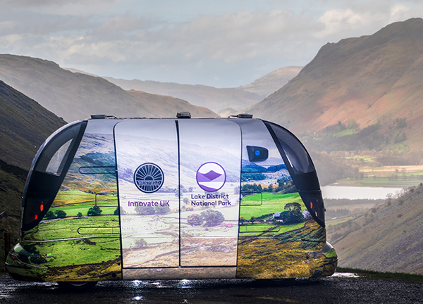
    Westfield Technology Group, a British vehicle manufacturer, and Ordnance Survey have signed a Memorandum of Understanding (MoU) to support autonomous vehicle development.

    The MoU will support a wider range of autonomous vehicle operations by improving access to detailed and accurate mapping.

    Project LAVIS is investigating how autonomous vehicles, particularly shared PODs, could offer residents and visitors sustainable and shared transport around the Lake District National Park area.

    Previous collaborations between Westfield Technology Group and Ordnance Survey include jointly collaborating with Emirates Airlines in Dubai and mapping potential autonomous vehicle routes in the Lake District for the Innovate U.K.-funded Project LAVIS.

    Recognizing the mutual benefits of collaborating on domestic and international activities, the organizations will continue developing and advancing autonomous vehicle capability. By utilizing 3D high-definition mapping capability, this partnership will add significant value the autonomous vehicle industry, the companies said.

    “We’re very excited about strengthening our working relationship with Ordnance Survey,” said Julian Turner, CEO at Westfield Technology Group. “This MoU will allow us to further advance and improve our autonomous vehicle operations, particularly in areas which desperately need access to sustainable, reliable and flexible transport.”

    “This MoU further cements our relationship with Westfield Technology Group,” said Andy Wilson, region director for Europe and Africa at Ordnance Survey. “We’re excited about collaborating on this important project, which is another example of how accurate, up-to-date geospatial data and mapping is key to the success of new and emerging technologies.”

  • Qianxun SI, u-blox plan to bring mass-market high-precision positioning to China

    Qianxun Spatial Intelligence Inc., a high-precision positioning service provider, and u-blox are joining forces to deliver high-precision positioning solutions to the Chinese market.

    By coordinating their product offerings, they seek to meet growing demand for increased positioning accuracy for mass-market applications. Some of the areas driving up demand for high-precision positioning services in China are internet of things (IoT) tracking devices such as those used on shared bikes, as well as automotive, UAV and robotic vehicle applications.

    u‑blox is bringing to the partnership its high-precision GNSS receivers. Its u‑blox F9 multi-band positioning platform uses integrated real-time kinematic (RTK) technology to process the high-precision positioning correction data provided by Qianxun SI, delivering down to centimeter-level positioning accuracy for wide-ranging applications. It enables even faster and more robust performance by leveraging a greater variety of GNSS signals.

    Two major advancements have enabled sub-meter-level positioning accuracy for mass-market applications. The first is modern GNSS correction services that constantly monitor GNSS signals to determine positioning errors caused, for example, by atmospheric distortions, and wirelessly transmit correction data to compensate for these errors to millions of GNSS devices. The second is a new generation of small, power-efficient, and affordable GNSS receivers that are able to use the correction data to achieve such high levels of accuracy.

    Qianxun SI, a high-precision positioning service provider, has already laid the groundwork for the large-scale expansion of high-precision positioning in the IoT era, the company said. Based on BeiDou, which is compatible with GPS, GLONASS and Galileo, Qianxun SI’s high-precision positioning service is built on the nationwide ONE Network, composed of more than 2,000 Continuously Operating Reference Stations (CORS) and using proprietary algorithms. It offers vehicles and other applications a range of 24/7 high-precision positioning services in most regions of the country.

    By the end of 2018, Qianxun SI’s dynamic centimeter-level service will cover the entire mainland of China, the company said.

    “We are delighted to cooperate with u-blox to provide users with high-precision positioning solutions that are user friendly and affordable,” said Jinpei Chen, CEO of Qianxun SI. “I believe our high-precision positioning technology is a key enabler of IoT development, and the cooperation with u‑blox will accelerate the go-to-market process of the technology in an extensive range of industrial and automotive market applications.”.

    “This collaboration is a genuine win-win for all involved in that it allows us to develop high-precision solutions that will foster innovation across markets,” said Thomas Seiler, CEO of u-blox. “Partnering with China’s leading GNSS correction service provider allows u-blox customers to bring cutting edge applications to the China market in the shortest possible time.”