Category: Applications

  • Sierra Wireless offers LPWA module with GNSS

    Sierra Wireless offers LPWA module with GNSS

    Sierra Wireless, a provider of fully integrated device-to-cloud solutions for the Internet of Things (IoT), is offering global, dual-mode low-power wide-area (LPWA) cellular modules. The AirPrime WP77 smart wireless modules simplify LPWA deployments for customers developing products that need to connect to multiple networks where different LPWA technologies are supported.
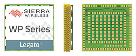
    The Sierra Wireless AirPrime WP Series.

    The WP series simplifies development for secure telematics and gateway applications, providing a dedicated application CPU core running the Linux-based open source Legato application framework.

    With integrated GNSS for tracking and location-based services, low-power modes and a comprehensive set of interfaces for connecting sensors and companion chips, including Wi-Fi and Bluetooth, customers can develop multi-service platforms for the transportation market, and use the WP77 for applications requiring low throughput and optimized power performance.

    The WP77 supports both LTE-M (Cat-M1) and NB-IoT (Cat-NB1) with optional 2G fallback, allowing customers to deploy the same device with multiple network operators worldwide. For those deploying in regions where 4G LTE coverage is not as widely available, 2G fallback ensures their devices stay connected to the network.

    ABI Research forecasts that cellular LPWA network technologies will begin to see rapid growth from 2018 onward as carriers upgrade their networks in 2017, however, carriers have varying plans and timelines for LTE-M and NB-IoT.

    “A module with dual-mode, global coverage will be very attractive for global equipment manufacturers, especially for applications such as telematics, metering, and location tracking, which we expect will lead the way for LPWA volume deployments,” said Dan Shey, managing director and vice president at ABI Research.

    With the commercialization of LTE-M and NB-IoT LPWA technologies, cellular is now a superior option for many IoT applications that were previously restricted to short-range technologies due to cost and battery life. LPWA technologies combine lower cost, broader coverage and better battery life with globally available and secure cellular networks and will connect millions more things to the Internet.

    “With the AirPrime WP77 modules, IoT developers have everything they need in a single module to quickly build low-power connected products that can be deployed anywhere in the world,” said Dan Schieler, senior vice president and general manager, Embedded Solutions, Sierra Wireless. “The integrated open source Legato platform and AirVantage cloud provide our customers with a proven device-to-cloud architecture to design innovative LPWA solutions that extend the IoT into new applications.”

  • Spirent Federal developing MNSA-capable simulators

    Spirent Federal Systems, a provider of GPS and GNSS simulators, has begun developing MNSA-capable GNSS simulators for the Modernized Navstar Security Algorithm.

    Spirent Federal is developing software that will support M-code using MNSA. M-code is an updated GPS military signal that is being rolled out as part of the modernization of the current GPS constellation.

    GPS modernization began in 2000 when the GPS Selective Availability feature was set to zero. Since that time, the U.S. Air Force has been working on newer generation satellites that will transmit new civilian and military signals.

    Until now, AES and SDS have been the only methods authorized to be used within a GNSS simulator to produce M-code.

    Spirent Federal Systems has been a provider of AES M-code and SDS M-code capable simulators for many years, but as the long awaited MNSA M-code signals become available, Spirent Federal Systems will be making this option available to authorized users on the GSS9000 series simulator.

  • Second set of Iridium NEXT satellites in orbit

    Second set of Iridium NEXT satellites in orbit

    The second set of 10 Iridium NEXT satellites, launched June 25 by SpaceX, are functioning nominally and have begun the testing and validation process.

    The batch of 10 satellites was launched from Vandenberg Air Force Base in California, increasing the total number of Iridium NEXT satellites in space to 20.

    “We are thrilled with yesterday’s success,” said Scott Smith, chief operating officer at Iridium. “These new satellites are functioning well, and we are pressing forward with the testing process.”

    “Since the last launch, the team at our Satellite Network Operations Center has been anxiously awaiting this new batch of satellites. There is a lot of work to do, and we are up for the challenge,” he said.

    Now, and for approximately the next 45 days, the newly launched satellites will undergo a series of testing and validation procedures, ensuring they are ready for integration with the operational constellation.

    Once testing is completed, Iridium will also hand over control of Aireon’s Automatic Dependent Surveillance-Broadcast hosted payload, to the team at Aireon’s Hosted Payload Operations Center, in Leesburg, Virginia.

  • Trimble launches VRS Now correction service in France

    The Trimble VRS Now GNSS correction service is now available in France. The service is designed for a variety of geospatial and construction applications including surveying, cadastral, land administration, and urban and rural construction that would benefit from easy access to high-accuracy, centimeter-level positioning.

    Trimble also now provides Galileo support for VRS Now. Powered by the Trimble Pivot Platform, VRS Now in Europe fully supports GPS, GLONASS, BeiDou, QZSS and the Galileo satellite system.

    Galileo support improves network performance and reliability with access to additional satellites, particularly in urban canyons or other harsh environments. The increased number of visible satellites provides additional data observations that enhance positioning integrity to better mitigate errors.

    “Trimble continues to aggressively expand its VRS Now footprint in Europe,” said Patricia Boothe, general manager of Trimble’s Advanced Positioning Division. “With the addition of correction services in France, Trimble VRS Now covers over 179 million square kilometers (732 million square miles) across 10 countries.”

    VRS Now coverage is available throughout the majority of France as well as Belgium, The Czech Republic, Estonia, Germany, Great Britain, Ireland, Luxembourg, the Netherlands and Sweden using a compatible GNSS receiver or display.

    Subscriptions are available through Trimble’s Authorized Business Partners or Trimble’s online store.

  • GPS tracking device market expected to grow 2017 to 2023

    The GPS tracking device market is expected to exhibit significant growth potential between 2017 and 2023, according to a new report by Research and Markets.

    The key driving factors for the growth of the GPS tracking device market include the increase in sales of commercial vehicles, smaller size, affordable price and high return on investment. Moreover, the advent of cellular technology reduced the service cost, while the decline in GNSS/GPS IC makes inroads in cellphone that provide the scale of economies to GNSS/GPS module supplier.

    The report is titled GPS Tracking Device Market by Type, Deployment Type, Industry & Geography – Global Forecast to 2023.

    Other findings:

    • Transportation and logistics to hold the largest share of the overall GPS tracking device market.
    • APAC will be the fastest-growing market for GPS tracking device during the forecast period.

    Learn more here.

  • Telit introduces Bluetooth module with integrated MEMS

    Telit has launched BlueMod+S42M, a Bluetooth low-energy (BLE) 4.2, standalone, single-mode module with embedded 3-axis accelerometer, temperature and humidity sensors.

    The cost-effective component is optimized for efficiency and simplicity in end-device design and manufacturing, delivering reliable BLE functionality with robust endpoint security, motion and environmental sensors and essential features that reduce development costs, bill of materials, and time to market.

    Designed for large-scale projects, the BlueMod+S42M expedites device design across a wide range of industrial and consumer applications areas, the company said. The embedded sensors are for high-value, fragile asset tracking, and time- or temperature-sensitive applications such as cold chain monitoring in the pharmaceutical and agriculture industries.

    The release of the certified BlueMod+S42M complements the Telit portfolio of Bluetooth and BLE modules and directly addresses the demand in the rapidly growing BLE-dependent market. A report released by IndustryARC Analysis, forecasts Bluetooth Low Energy enabled devices shipments to increase to 8.4 billion units by 2020 at a CAGR of 29 percent.

    “Cost, power, and reliability are critical to the success of IoT applications that demand efficient BLE solutions,” said Ronen Ben-Hamou, Telit EVP of products and solutions. “Our new qualified Bluetooth module caters to designers of all levels with tight development, materials and manufacturing cost constraints and even tighter timelines. The beauty of the +S42M is it’s simplicity: single-chip SoC (system on chip), feature packed, sensibly priced, exceptional power savings and extensive interoperability.”

    Full applications can be embedded in the BlueMod+S42M, which is a self-contained SoC requiring no additional external supporting components. It is equipped with an on-board micro controller, integrated chip antenna, passive components, T°/Humidity sensor, and an accelerometer.

    Leveraging a rich subset of features from Telit’s diverse family of BlueMod+Sx modules, including a GATT interface and terminal I/O profile combination, the new BlueMod+S42M greatly simplifies and accelerates the development of applications, Telit said.

    In addition to efficient performance and low power consumption, BlueMod+S42M includes value-added features that further streamline development:

    • Bluetooth v4.2 Qualified Module
    • RED, SRCC Certified
    • Generic GATT Client and Server
    • LE Secure Connections
    • Configurable DIS (Device Information Service)
    • LE Data Length Extension
    • Terminal I/O for Easy Transparent Data Transfer (BLE- SPP like)
    • Embedded Sensors
    • Over-the-Air Updates
    • Sample Code for iOS and Android
    • WeChat Air Sync Protocol

    Designers using the BlueMod+S42M have access to comprehensive development and integration tools including evaluation and development kits.

    Visit Telit at the Sensors Expo in San Jose, California, June 27-29, booth 1244.

  • Location and context advances in Android

    Location and context advances in Android

    Plus access to raw GNSS measurements for all

    By Steve Malkos
    Technical program manager, Google

    Google’s annual developers conference in May, Google I/O, featured many announcements, accomplishments and 2017 plans. Of particular interest, the Android Location and Context Team’s talk “Android Sensors & Location: What’s New and Best Practices,” is available online.

    This followed a keynote by CEO Sundar Pichai on solving problems at scale with deep neural networks, machine learning algorithms and artificial intelligence (AI). He also spoke about a shift from a mobile-first model to AI-first. Google is doing this across every product area, applying AI and machine learning. Other keynotes updated Assistant, Photos, YouTube, Superchat, Android and VR (virtual reality).

    The Android Location and Context team — Marc Stogaitis, Wei Wang, Souvik Sen and myself — spoke about background location, location accuracy, activity recognition, Android sensor hub, Android sensors, and the future of location and context.

    Discussing why battery life is so important, we showed detailed graphs on the costs of accessing different parts of the phone subsystems like WiFi, GNSS and making data connections.

    Then we introduced Background Location Limitations (at the 4:30 point in the posted video) coming with Android’s latest operating system in Android O. These limits will prevent applications from misusing Android’s APIs in the background, thus saving its user’s battery. There were examples on how to make your app background ready for these upcoming changes.

    We showed plans for location accuracy improvements (12:50) coming later this year and comparisons of existing vs. upcoming solutions for the positioning algorithm.

    We covered the tools to help analyze GNSS measurements. How strong are the individual measurements? How accurate are the range measurements? With these tools, developers now have direct insight into the lowest layers of a GNSS receiver. Then came activity recognition algorithms (15:40) and how deep neural networks will improve the precision of these algorithms and help advance the field in activity recognition.

    I spoke spoke about the Android Sensor Hub (20:27), how Google is leveraging the capabilities of an always-on low-power processor in Android phones. The sensor hub allows Google to port algorithms such as Activity Recognition, Geofencing and Gestures from the main application processor into the low-power sensor hub. We then went into detail around the new sensor features (25;55) and improvements around the compass (28:34).

    Finally, we looked into the future (33:28). I covered Project Elevation, Accurate Indoor Location, and dual-frequency GNSS. Closing thoughts were around how more signals are going to be added into the low-power always-on compute domains so that the phone is more aware and intelligent, simplifying users’ interactions, augmenting human memory and knowledge, and assisting users understanding of themselves and the world around them.

    Access to Raw GNSS Measurements

    In related news, our new web page is up and operational!  This site provides all the details around GNSS Raw measurements in Android along with our analysis tools for anyone to download. Our previous site was accessible to people who signed up as a partner with Google, but now we have opened up this site to everyone.

    Android GNSS Analysis Tool: Shows how you can select and run the analysis on a per satellite basis. This tool now supports multi-constellation and dual frequency (L1+L5) by default

    Android apps typically access GNSS chipsets through a filter, which improves the GNSS location output for the majority of use cases. Filters use additional sensors, such as motion sensors, to improve the end user experience. However, filtering is not appropriate for some applications used by professionals such as researchers and original equipment manufacturer (OEM) developers. The Android Framework provides access to raw GNSS measurements on some Android devices. The page lists Android devices that support raw GNSS measurements as well as tools that help you log and analyze GNSS data.

    For more on Android and raw GPS measurements, see the GPS World Innovation article Precise positioning using raw GPS measurements from Android smartphones.

  • Hexagon launches HxGN AgrOn Logistics harvest solution for sugarcane, forestry

    Hexagon launches HxGN AgrOn Logistics harvest solution for sugarcane, forestry

    Hexagon, a global provider of information technology solutions, has launched HxGN AgrOn Logistics, an end-to-end solution enabling sugarcane and forestry producers to manage and optimize the complex logistics processes essential to harvest.

    HxGN AgrOn Logistics will be officially unveiled today at Agrishow, one of the world´s largest agricultural technology trade shows, in Ribeiro Preto, Brazil.

    “In agriculture and forestry operations, success is defined by productivity,” said Hexagon President and CEO Ola Rollén. “Efficiently moving product from field to processing is one of the most critical phases of production, and one filled with logistical risks. HxGN AgrOn Logistics is streamlining and optimizing this entire process,”

    AgrOn Logistics simplifies harvest with communications, insights and operations that are continuously optimized — from planning to field to processing. Real-time communications between machines enable easy coordination, while advanced software handles monitoring, capacity planning, scheduling, dispatching, resource management and more intensive data analysis.

    The benefit to sugarcane and forestry harvest operators is complete connectivity, with workflow synchronization that optimizes every step of the process – from planning to dispatching to real-time execution and full machine automation.

    Field-tested by more than 70 producers, AgrOn Logistics users are experiencing steep productivity gains and sharp decreases in raw materials loss, Hexagon said,

    HxGN AgrOn Logistics will put data to work for a more intelligent approach to harvest: connecting, synchronizing and optimizing workflows, people and information while reducing operating expenses.

  • Septentrio bestows Ecochallenge Award on Leuven University team

    Septentrio bestows Ecochallenge Award on Leuven University team

    Septentrio, a designer and manufacturer of GNSS solutions, has awarded the Katholieke Universiteit Leuven (KU Leuven) Ecochallenge team — the winners of the Galileo Masters (Flanders Challenge) of the European Satellite Navigation Competition (ESNC) — with an AsteRx-m UAS receiver for its proposal to use high-precision high-reliability Galileo receivers to modernize inland waterway transport by introducing autonomous technology for the vessels.

    The judging panel were impressed with the proposal from the KU Leuven Ecochallenge team to use high-quality Galileo receivers to improve the safety and efficiency on autonomous and existing vessels, which can be retrofitted with the solution.

    The ambitious proposal offers a pragmatic step towards rejuvenating inland waterways as a viable ecological alternative for freight transportation, Septentrio said in a news release.

    The KU Leuven team also participated in Ecorace Challenge organized by the Flemish Waterways Agency and was both the overall winner in the cargo category as well as being voted the most innovative vessel in 2016.

    The AsteRx-m receiver board won by KU Leuven Ecochallenge team is a GNSS solution for applications in autonomous and unmanned vehicles, such as drones. The AsteRx-m UAS offers centimeter-level accuracy at 700 mW using L1/L2 GPS and GLONASS RTK.

    The AsteRx-m OEM Board by Septentrio.

    “As traffic continues to increase, exploiting inland waterways has been identified as a critical development for easing the pressure on road networks,”  said Jan van Hees, director of business development at Septentrio. “High-precision high-reliability positioning technology using GNSS is an essential element of the development. The KU Leuven team have demonstrated an innovative autonomous small vessel prototype already to move cargo safely and efficiently on the Flemish waterways, and we look forward to continued collaboration as they further develop this technology for bigger ships.”

    “The team is very pleased with their performance winning the Septentrio Prize and the Ecorace Challenge together in the same year,” said Geert Waeyenbergh of KU Leuven, who mentored the KU Leuven Ecochallenge team. “The received AsteRx-m will further help research and development of better ships going into the future.”

  • Cobham launches next-generation GPS anti-jam system at Paris Air Show

    Cobham launches next-generation GPS anti-jam system at Paris Air Show

    Cobham Antenna Systems has launched its next-generation anti-jam GPS system.

    The system provides significant immunity to jamming compared with a conventional GPS antenna, allowing the platform to operate over 100 times closer to the jammer whilst maintaining its GPS reception, the company said.

    The system will be available to view on Cobham’s stand, hall 2b, stand E156, at the International Paris Air Show, which is taking place June 19-25.

    The compact size and modularity of the DACU and CRPA, as well as being receiver independent, means that the system can be installed in land and marine applications. (Photo: Cobham)

    “Cobham has been a global leader in development of anti-jam technology for over 20 years, and we are delighted to be launching launch our next generation anti-jam GPS system at Paris Air Show,” said David Bulley, vice president of Cobham Antenna Systems. “The system provides significant immunity to intentional or unintentional jamming compared with a conventional GPS antenna, thereby protecting mission critical systems that require assured position, navigation and timing information from GPS.”

    The system consists of a 7-6005 anti-jam GPS digital antenna control unit (DACU) and a four-channel 20-7009 anti-jam GPS controlled reception pattern array (CRPA) antenna. Both units meet stringent airborne requirements making them ideal for new installations and retrofitting to fixed-wing, rotary-wing and UAV platforms.

    The compact size and modularity of the DACU and CRPA, as well as being receiver independent, means that the system can also be installed in land and marine applications so offering a single solution for all platforms.

    The high-performance, four-channel antenna and electronic system, offers the optimum balance between size, weight, power and cost. Intelligent, dual-band protection is provided with processing optimized to combat the threat environment.

  • Research Online: Tight integration algorithms designed for cars

    Research Online: Tight integration algorithms designed for cars

    Image: Authors
    Image: Authors

    By Gianluca Falco, Gianluca Marucco, Mario Nicola and Marco Pini, Istituto Superiore Mario Boella (ISMB) / Presented at ION ITM, January 2017

    The authors of this paper deal with the development of a Robust Position Unit (RPU) based on the real-time implementation of an advanced positioning algorithm. The RPU uses a tightly coupled technique between a mass-market single-frequency GNSS chipset with a low-cost inertial measurement unit (IMU) based on micro-electro-mechanical systems (MEMS) and an odometer.

    The tight integration algorithm has been obtained through the design of a complex extended Kalman filter (EKF). Its performance has been verified running the designed real-time algorithm in different challenging environments. One is an urban scenario characterized by narrow streets, few satellites in view and tree-lined avenues. A second harsh environment is represented by a mountain area where the vehicle has driven through long tunnels, overpasses and sharp road bends.

    The tests showed how a tight integration algorithm, designed by using raw data from only low-cost sensors, can provide real advantages at a price of careful customizations and adaptations that take into account the particular use and environment.

    In the designed tight algorithm, additional features and constraints were added with respect to a common tight strategy in order to provide a navigation solution targeted for land applications. Results show a significant decrement of the positioning errors compared to those obtained with other commercial devices. In particular, the tightly-coupled algorithm provides better estimates of the vehicle position and attitude in case of an urban scenario. The improvement was measured following a standardized testing method, considering the horizontal position error and the yaw angle, as the main performance metrics.

    Moreover, the advantages of the embedded system based on an ad-hoc tightly-coupled strategy become even more evident in case of a mountain road that is characterized by frequent tunnels and steep slopes. The experimental results demonstrate the possibility to employ tightly-coupled architectures in low-cost mass-market devices. In the future, the improvement of MEMS technology and the evolution of GNSS, with enhanced signal formats, different frequency bands and more satellites in view, are expected to further increase the positioning performance of mass-marked devices, enabling a variety of new services for road users.

  • Leica Geosystems offers complete imaging solution

    Leica Geosystems offers complete imaging solution

    Leica Geosystems’ BLK360 is a miniaturized black 3D imaging laser scanner. The BLK360 captures the world with full-color panoramic images overlaid on a high-accuracy point cloud.

    The one-button Leica BLK360 is easy to use, Leica said. Anyone who can operate an iPad can now capture the world around them with high-resolution 3D panoramic images.

    The Leica BLK360 imaging laser scanner is so small and light that it fits in a typical messenger bag. It features a 60-meter measurement range for full dome scans. A complete full-dome laser scan, 3D panoramic image capture and transfer to the iPad Pro takes only 3 minutes.

    Using the ReCap Pro 360 mobile app, the BLK360 streams image and point cloud data to iPad. The app filters and registers scan data in real time. After capture, ReCap 360 Pro enables for point cloud data transfer to a number of computer-aided design, building information modeling, virtual reality and augmented reality applications. The integration of BLK360 and Autodesk software streamlines the reality-capture process, opening the technology to non-surveying individuals.