Category: Applications

  • Beacons by Waze counter tunnel blackout

    Beacons by Waze counter tunnel blackout

    fort-pit-tunnel

    To assist drivers losing their navigation assistance in tunnels such as those in New York, Baltimore, Boston and Pittsburgh, app maker Waze has begun pilot projects installing electronic beacons. Each about the size of an E-ZPass, the beacons are installed within tunnels to guide the way via Bluetooth. No GPS signal in the tunnel means no directions upon emerging into daylight. That can cause a missed exit — or worse.

    Waze spokesperson Meghan Kelleher said one beacon is placed every 40 feet or so to provide seamless smartphone navigation throughout the tube and to allow people to note traffic troubles on the crowdsourcing app. But even non-Waze users can benefit.

    “It’s actually an open technology,” Kelleher says. “We’re making it available free of charge to other navigation services.”

    Each mile of beacons costs about $300 per year. The hardware is made by Bluvision with batteries are designed to last about six years.

    Waze has just switched them on in the Fort Pitt and Liberty tunnels in Pittsburgh with an eye on getting governments and other agencies to foot the bill in the rest of the world’s tunnels.

    Photo: the justified sinner via Foter.com / CC BY-NC-SA

  • GPS III 9 and 10 procured, targeting 2022 launch

    GPS III 9 and 10 procured, targeting 2022 launch

    The first eight GPS III satellites are under contract and in production at Lockheed Martin’s GPS III Processing Facility outside of Denver.
    The first eight GPS III satellites are under contract and in production at Lockheed Martin’s GPS III Processing Facility outside of Denver.

    The U.S. Air Force Space and Missile Systems Center awarded a contract option to Lockheed Martin Space Systems Company to procure two additional GPS III satellites, space vehicles nine and 10 of the next generation. The contract option procures long lead and production hardware.

    “The GPS III SV 9 and 10 satellites are expected to be ready for launch in 2022, thus sustaining the GPS constellation and the global utility the world has come to expect,” said Lt. Gen. Samuel Greaves, the Space and Missile Systems Center’s commander and Air Force program executive officer for space.

    The Lockheed Martin team is finishing up final testing and integration activities on the first GPS III satellite, GPS III SV01, and is preparing to deliver it to the Air Force later this year. The second satellite, GPS III SV02, is poised to have its major functional systems fully integrated into one space vehicle prior to starting its own environmental testing. GPS III SV03 also is beginning to take form in the company’s production clean room as its major subcomponents are being assembled.   \All eight of the first set of GPS III satellites are in various stages of production at Lockheed Martin’s GPS III Processing Facility outside of Denver.

    190921-f-zz999-108The government expects to compete future purchases of GPS III satellites, beginning with GPS III SV 11. This competition will maintain the current technical baseline of GPS III and will add additional hosted payloads to increase system accuracy, search and rescue capability, and universal S-band compatibility.

  • High-accuracy, intelligent performance with sensor fusion

    High-accuracy, intelligent performance with sensor fusion

    Inertial navigation

    geo_fog_single-3d-wThe GEO-FOG 3D inertial navigation system (INS) uses sensor fusion to deliver reliable, high-accuracy navigation and control to a wide variety of unmanned, autonomous and manned aerial, ground, marine and subsurface marine applications and platforms. Other applications include navigation and control, positioning and imaging, georeferencing, land surveying, robotics, underground navigation, stabilization and orientation.

    Designed for demanding navigation and control applications, the GEO-FOG 3D has performance monitoring and instability protections to ensure stable and reliable data. Using an innovative artificial intelligence algorithm, its intelligent high-performance filter is capable of extracting significantly more information from the 1750 IMU core processor than a typical Kalman filter.

    The GEO-FOG 3D is built upon the high-performance fiber-optic gyro (FOG)-based 1750 inertial measurement unit (IMU). It contains three DSP-1750 fiber optic gyros integrated with three very low noise micro-electro-mechanical systems (MEMS) accelerometers as well as a pressure sensor, a three-axis magnetometer, and a triple-frequency GNSS receiver.

    The triple frequency receiver provides 8 millimeters of positioning accuracy and supports all GNSS systems. It also offers data rates up to 1000 Hz; data can be output over a high-speed RS-422 interface or optional RS-232 interface. The rugged GEO-FOG 3D INS is protected from reverse polarity, overvoltage, surges, static and short circuits on all external surfaces.

    Key Features

    • Core processor: KVH 1750 IMU
    • 6 degrees of freedom (DoF) IMU consisting of integrated FOGs and accelerometers
    • Triple-frequency Trimble GNSS receiver
    • Sensor fusion algorithm delivers accurate, reliable data for navigation, orientation, and control
    • North-seeking gyrocompass
    • Attitude and Heading Reference System (AHRS)

    KVH, www.kvh.com/unmanned

  • Harris delivers first OCX receiver

    Harris delivers first OCX receiver

    Photo: Harris
    Photo: Harris

    Harris Corporation delivered the first of 34 modernized receivers to support the GPS Next-Generation Operational Control System (OCX). They will receive the signals sent by the current GPS satellite constellation plus the new signals sent by the next generation GPS III — 13 military and civilian signals in all.

    The receiver was shipped to the prime contractor, Raytheon Company, in Aurora, Colorado, after it passed a critical electromagnetic interference test, the first of many stringent qualification requirements. Though the receivers will be placed throughout the world, this first production unit will be installed in Aurora as OCX software development and integration continues.

    OCX will replace the existing ground control system that receives signals from the 31 operational GPS satellites already orbiting Earth. Only OCX will be able to receive and decrypt all GPS III military and civil signals, however.

    In addition to receivers, Harris has delivered 14 ground encryptors that will help protect the GPS signal. Harris also is providing critical software elements, which provide the fundamental navigation data to the GPS satellites and enable U.S. Air Force operators to better know and monitor the exact position and timing of the GPS constellation.

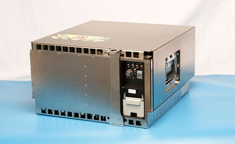
    Pictured here is the advanced MDU on navigation payloads being delivered for GPS III Space Vehicles 1-10. (Photo: Harris)
    Pictured here is the advanced MDU on navigation payloads being delivered for GPS III Space Vehicles 1-10. (Photo: Harris)


  • Launchpad: TraceME TM-178 is upgraded with LoRa technology

    Tracking with options

    The TraceME module TM-178, targeted for tracing and controlling vehicles and other powered equipment, is now upgraded with optional LoRa, Wi-Fi, Bluetooth Smart (BLE), ANT/ANT+ and proprietary RF. The upgrades enable integration with existing wireless networks and specific custom mobile apps on smartphones and tablets.

    productheader-r9hc-kcsbv-wThe KCS BV LoRa technology offers a communication range up to 60 kilometers, line of sight. The module offers an advanced indoor and outdoor location-based positioning solution, which covers a variety of Internet of Things (IoT) applications and enables stolen object or vehicle recovery.

    The TM-178 is equipped with external power and battery backup connection, basic I/O-connectivity and multiple on-board sensors. The unit contains multiple integrated antennas for GPS/GLONASS, GSM (2G/3G) and RF functionality. The functionality of the module can be remotely programmed to fit any job. From basic/general functionality to advanced/low-level application specific detailed functionality.

    With a compact size of 91 x 40 millimeters and weighing 30 grams, along with a battery lifespan of more than 10 years, the module offers endless OEM integration possibilities. Optionally, the module can be ordered in a robust IP67 housing.

    TM-178 Features

    • GPS
    • GSM/GPRS/EDGE coverage
    • Basic I/O-connectivity
    • Long-range RF coverage

    Optional Features

    • GPS + GLONASS
    • UMTS/HSPA+
    • LoRa
    • Bluetooth Smart (BLE), ANT/ANT+, iBeacon
    • Wi-Fi
    • Robust IP67 housing
    • External RF antennas
    • Internal battery, no need for external power supply

    KCS BV, www.trace.me

  • DARPA floats aerial surveillance Dragnet by UAV

    DARPA floats aerial surveillance Dragnet by UAV

    As off-the-shelf unmanned autonomous systems (UAS) become less expensive, easier to fly, and more adaptable for terrorist or military purposes, U.S. forces will increasingly be challenged by the need to quickly detect and identify such craft, especially in urban areas, where sight lines are limited and many objects may be moving at similar speeds.

    To map small UAS in urban terrain, the U.S. Defense Advanced Research Projects Agency (DARPA) seeks innovative technologies to provide persistent, wide-area surveillance of all UAS operating below 1,000 feet in a large city. While the newAerial Dragnet program focuses on protecting military troops operating in urban settings overseas, the system could ultimately find civilian application to help protect U.S. metropolitan areas from UAS-enabled terrorist threats.

    “Commercial websites currently exist that display in real time the tracks of relatively high and fast aircraft—from small general aviation planes to large airliners—all overlaid on geographical maps as they fly around the country and the world,” said Jeff Krolik, DARPA program manager. “We want a similar capability for identifying and tracking slower, low-flying unmanned aerial systems, particularly in urban environments.”

    Although several systems are being developed for tracking small UAS by extending surveillance methods used in open areas where large line-of-sight buffers mitigate the threat, these systems are impractical for operation in urban terrain. Aerial Dragnet seeks to leapfrog these approaches by developing systems adapted to the fundamental physics of small UAS in urban environments that could enable non-line-of-sight (NLOS) tracking and identification of a wide range of slow, low-flying threats.

    The program envisions a network of surveillance nodes, each providing coverage of a neighborhood-sized urban area, perhaps mounted on tethered or long-endurance UAS. Using sensor technologies that can look over and between buildings, the surveillance nodes would maintain UAS tracks even when the craft disappear from sight around corners or behind objects.

    Low Cost Sensors, SDR. The output of the Aerial Dragnet would be a continually updated common operational picture of the airspace at altitudes below where current aircraft surveillance systems can monitor, disseminated electronically to authorized users via secure data links. Because of the large market for inexpensive small UAS, the program will focus on combining low-cost sensor hardware with software-defined signal processing hosted on existing UAS platforms. The resulting surveillance systems would thus be cost-effectively scalable for larger coverage areas and rapidly upgradeable as new, more capable and economical versions of component technologies become available.

    The Aerial Dragnet program seeks teams with expertise in sensors, signal processing, and networked autonomy to achieve its goal. A solicitation detailing the goals and technical details of the program was posted here. A Proposers Day took place in late September.


    Inertial, Gyroscope Take to Space


    The concept image above shows the NEA Scout CubeSat with its solar sail deployed as it characterizes a near-Earth asteroid. (NASA)

    Sensonor AS of Norway has partnered with the U.S. National Aeronautics and Space Administration (NASA) to supply current and future low- and near-Earth orbit space missions with inertial and gyroscope modules.

    The Norway-based company first began supplying its standard inertial measurement unit (IMU) and gyroscope modules for low Earth orbit (LEO) space applications in 2012, Sensonor’s STIM300 and STIM210 inertial products now fly aboard several NASA spacecraft. Current projects using STIM inertial systems include the Raven technology demonstration and Near Earth Asteroid (NEA) Scout.

    Raven, which launched to the International Space Station in September, will test key elements of an autonomous relative navigation system. Its technologies may one day help future robotic spacecraft autonomously and seamlessly rendezvous with other objects in motion, such as a satellite in need of fuel or a tumbling asteroid.

    The NEA Scout is a robotic reconnaissance mission that will be deployed to fly by and return data from an asteroid representative of NEAs.

    The STIM gyroscope modules are often used in combination with GPS or a Star Tracker and Kalman filter to orient and stabilize the satellite, as well as to provide feedback on satellite motion induced by its reaction wheels. In some applications, the gyroscopes are used to stabilize satellite-to-satellite communications.


    Lighting Up Indoors for Retail Position

    A new indoor positioning system uses LED lighting to pinpoint location for use in the retail industry. Researchers from the University of South Australia have developed an indoor positioning system that tracks movement with greater accuracy than contemporary RFID and Wi-Fi based systems.

    Developer Siu Wai Ho said other methods of indoor positioning such as Wi-Fi were only accurate to within 1–2 metres and were easily hampered by radio frequencies from nearby devices, power sources or other wireless electronics. “Our system is more accurate with an error margin of 10cm and unlike some positioning systems our algorithm can calculate the orientation at the same time.”

    LiPo uses LED lights as transmitters and photodetectors as receivers because they are both common items in modern societies. Photodetectors are a key component for capturing light and are also commonly found in smart phone cameras. The system uses a specially designed receiver to measure light intensity that is able to calculate position and orientation. Although it currently requires a unique receiver, developers hope to integrate the technology with the photodectors in mobile phones. This would reportedly enable supermarkets to provide customers with relevant information about items nearby.

    “If you are in a supermarket you want to see some information for a product in front of you. One or two metres of error is still too big because it maybe gives you a product you are not in front of.”
    Other applications could include the identification of objects or machinery in factories, movement aid tools for the elderly and trackers for museums to provide relevant information to tourists as they passed by exhibits.

    Munich SatNav Summit Stresses GNSS Back-Up

    “Is it Time for GNSS Back-Up?” has been announced as the the theme of the 2017 Munich Satellite Navigation Summit, to take place March 14–16.International experts gather to discuss recent position, navigation and timing develeopment and the necessity for GNSS backup solutions.

    Among the topics, in addition to system updates on all major GNSS, we find listed: From Iridium to e-Loran — GNSS in need for a Backup; Galileo after the Brexit; Civil use of the Galileo Public Regulated Service (PRS); and Network-based solutions for GNSS Backup. Go to to www.munich-satellite-navigation-summit.org for registration information.


    Xsens Offers Knowledge BASEd Inertial Motion Tracking

    Xsens has launched BASE, an online technology platform with a community forum and a knowledge base on 3D motion tracking technology and products. BASE.xsens.com, contains inside information about micro-electro-mechanical system (MEMS) sensors, inertial measurement units (IMU), sensor fusion algorithms, body-motion tracking and motion capture.

    It also provides best practices, tips and tricks for the use of Xsens’ MTi series, the MTw and the MVN wearable motion capture solutions. A second section of BASE is the community forum with direct access to Xsens’ engineers and other Xsens users.

    There is no need to register for BASE to access the community forum and the knowledge base. To ask questions or comment on articles, registration is possible via SSO or email.

  • New GPS study finds 200 gigatons of ice missing

    A new study based on GPS measurements of the Earth’s crust suggests the Greenland ice sheet is melting 7 percent faster than previously believed and may contribute more to future sea level rise than predicted, reports the Canadian Broadcasting Corporation.

    “We’ve underestimated the rate of ice loss by about 7.6 percent,” says Michael Bevis of The Ohio State University, one of the study’s co-authors.

    The research found that Greenland lost close to 2,700 gigatons of ice from 2003–2013, rather than the 2,500 gigatons figure that scientists previously believed. The study, published in the journal Science Advances, is an international effort that started in 2007, with contributions from the U.S., Denmark and Luxembourg.

    Over the past two decades the Greenland ice sheet has been shrinking — partly due to accelerated glacier flow and partly because of surface melt. However, scientists have not been able to pinpoint exactly how much the melting ice sheet is contributing to global sea level rise — information key to making predictions about future sea rise levels.  Part of the challenge has been a lack of on-site data.

    For this study teams of scientists spent years installing GPS devices around the  perimeter of the Greenland ice sheet to collect new data. The team discovered that the hotspot in the Earth’s mantle that feeds Iceland’s active volcanoes has been distorting data.

  • HellaPHY wireless positioning better than 50 meters for IoT

    Acorn Technologies Inc., a semiconductor and wireless technology company focused on the Internet of Things (IoT), has developed and  demonstrated new wireless long-term evolution (LTE) positioning technology for the location of things. The LTE location-based technology meets the new Enhanced 911 (E911) mandate performance requirements and performs well in very low bandwidth conditions. HellaPHY technology provides better than 50-meter accuracy for next generation location of things in the machine-type communications (MTC) and IoT markets.

    Location of devices acts as an organizing principle for anything connected to the internet, helping organize the billions of internet-connected devices based on the sensors and other location-centric elements in them. The installed base of IoT endpoints will grow to more than 25 billion in 2019, hitting 30 billion in 2020, according to a recent IoT forecast.

    “We are achieving accuracy in low bandwidth scenarios,” says Steven Caliguri, VP of wireless products at Acorn Technologies. “We believe that our advanced LTE positioning solution is the lowest complexity, lowest cost and lowest power solution available today for LTE based applications from high-end smartphones to loT.”

    Acorn has demonstrated better than 50-meter accuracy in live network testing of their user equipment (UE)-based positioning algorithms for low bandwidth CAT-M devices. (Cat-M refers to Category M, the second generation of LTE chipsets meant for IoT applications.) The network tests were conducted on a network that has not been fully optimized for LTE-based positioning.  Further gains are expected when optimizations begin to rollout.

    Acorn’s network testing has demonstrated the ability to exceed the 2021 E911 mandated performance requirements even in low-bandwidth scenarios.

    The technology has been developed from the core hellaPHY Channel Estimation algorithm that employs machine-learning techniques. The positioning algorithms are  suited for IoT applications due to their extremely low complexity, and require less then 10 kilobytes of memory and only a fraction of a low-end DSP during the maximum processing interval. It has further proven to exceed the performance of super resolution algorithms at a fraction of the complexity.

    HellaPHY RSTD is an advanced signal processing algorithm that was developed to improve LTE wireless network indoor and outdoor location accuracy. It is designed to be a drop-in replacement for existing Reference Signal Time Difference (RSTD) algorithms in UE chipsets and can be customized for any unique DSP or interface requirements. The hellaPHY RSTD IP core is designed to support advanced LTE features contemplated by operators as well as for LTE Release 14 including Positioning Reference Signals (PRS) muting, Cell-Specific Reference Signal (CRS) plus PRS transmit diversity, and fractional Ts reporting. The hellaPHY RSTD IP core is scalable and can support CAT-M through CAT-15.

    (” … the ubiquitous parameter Ts. This nameless parameter is the most basic unit of time in the LTE air interface and pretty much everything in the LTE frame structure is based on multiples of this basic time unit, capital “T”, sub small “s”. Ts is defined exactly as: Ts = 1/(15000 x 2048) seconds, a little more than 32 nano-seconds.”

    — from LTEuniversity.com)

    Acorn Technologies is a provider of performance scaling semiconductor and wireless intellectual property for the Internet of Things. With nearly 200 patents issued and pending, Acorn’s IP addresses the fundamental building blocks with algorithms for wireless and IoT. The company’s semiconductor IP portfolio includes buried silicon stressors and metal insulator silicon  technologies to significantly boost semiconductor transistor performance.

  • Galileo Initial Services looming

    With Galileo Initial Services at last on the horizon and a quadruple satellite launch scheduled for November, here’s hoping that Europe’s GNSS constellation will be delivering limited, but reliable, global PNT services before the year is out.

    The four Galileo satellites for Arianespace’s first Ariane 5 mission for the constellation are being prepared at ESA’s launch facility in French Guiana. The flight is scheduled for 17 November. However neither these four new satellites, nor the two orbited in May, are required to deliver Galileo Initial Services, which should be launched officially some time in November. Fingers crossed.

    The European GNSS Agency (GSA) is gearing up to assume its operational role for Galileo in early 2017. During the summer the GSA formally accepted their Loyola de Palacio facility in Madrid, Spain that houses the European GNSS Service Centre (GSC). This is a significant milestone in the development of the programme and its service provision as Galileo’s “door to the GNSS world” as GSA Executive Director Carlo des Dorides described the facility at the handover ceremony.

    GSA already oversees the operation and service provision for the European Geostationary Navigation Overlay Service (EGNOS) (since 2015) along with managing the security accreditation and general security provision for both programmes.

    The GSC offers over 1,100 square metres of space and currently employs over 40 people. Since 2013, the core team at GSC has been providing limited services and working as a precursor to GSC v1. Its key work includes supporting the lead up to Galileo Initial Services provision, along with operating the GSC Helpdesk, disseminating orbital products to the Search and Rescue (SAR) community, supporting GNSS-related research and industrial activity and monitoring user satisfaction. Once operational, GSC v1 will be connected to the Galileo core system, thus enabling the long anticipated Commercial Service. This service is expected to enter operations by mid-2017.

    Once the Galileo Operations Contract is awarded and Initial Services officially declared, the GSC is expected to see a significant increase in staff.

    Also in the summer CNES President and France’s inter-ministerial coordinator for European satellite navigation programmes Jean-Yves Le Gall was elected as the new chair of the GSA Administrative Board with Mark Bacon, representing the United Kingdom, elected as deputy chair.

    “I am honoured to have been elected chair of the GSA Administrative Board, with Galileo now poised to enter its operational phase,” said Le Gall. “This election confirms the desire of Member States to join forces on the cusp of a prolific period for European space as we move Galileo towards full operational capability.”

    Brexit blues?

    Mark Bacon added “I am very pleased to have been elected to work with the Board and I look forward to helping the GSA deliver on the Galileo and EGNOS programmes over the coming years.”  However the UK’s decision to leave the EU (Brexit) must make his position rather uncomfortable – and temporary – to say the least.

    The GSA Administrative Board is composed of representatives from each EU Member State, the European Commission, and the EU parliament. The Board meets three times per year to ensure that the Agency performs its tasks correctly. As things stand if the UK is no longer an EU Member State it must lose its representative(s) on the advisory board.

    However, the relationship between the UK and EU space programmes is, of course, subject to the Brexit negotiations. The UK will almost certainly remain a member of the European Space Agency (ESA) as this is a pan-European body not an EU agency, however when it leaves the EU the country will have to renegotiate terms if it wants to continue to participate in the key EU programmes such as Galileo GNSS and Copernicus Earth Observation system.

    The ESA is autonomous from the EU and should not be directly affected by Brexit confirmed Jean Bruston, head of ESA’s EU policy office at a media briefing in mid-September. But “As soon as it [Britain] is leaving the EU it is not participating in these programmes [Galileo / Copernicus] any longer,” he observed.

    In addition, UK-based companies hold contracts worth tens of millions of euros from ESA to supply hardware for the Copernicus and Galileo GNSS. “If nothing changes [and Brexit goes ahead], we would have to stop these contracts,” said Bruston bluntly.

    Of course, Britain could still contribute to Galileo and Copernicus if it negotiated a third-party agreement with the EU, as Norway and Switzerland (both non EU members) have done. The down side is that this may take some time to initiate, let alone complete, and if Britain sticks to its guns on issues such as free movement of people then the likelihood of a successful outcome for the UK is not high.

    In an interview with French media ESA director-general Jan Woerner reinforced Bruston’s views saying that “the UK will remain a member state of ESA, this is very clear” but also continuing “As we are also dealing with European programmes like Copernicus and Galileo, and also the question of UK citizens working on the continent and all these legal issues, we have to take this into account.”

    EU opportunity

    Many in ‘continental Europe’, as we Brits so often condescend to describe our fellow Europeans, will be more than happy to see the U.K. no longer participating in deciding key aspects of EU space and other policy areas.

    It is no coincidence that the European Commission has become much more vocal on plans for a European defence force since the Brits announced their departure. The U.K. has long been opposed to the concept of an ‘EU Army.’ However planning and military cooperation between Member States outside normal NATO channels has been increasing over many years. The small and discreet (so discreet that I didn’t realise the exact location of its HQ in Brussels until the recent terrorist incidents meant burly Belgian paratroopers were stationed outside and I asked them what they were guarding. Has to be said they were not discreet!) has seen its budget frozen for the last five years, but this may now change.

    The interface of EU space and defence policy – in particular ‘dual use’ issues – will also become simpler without the U.K.’s protests. A leaked draft of the upcoming EU Space Policy communication talked directly of dual-use synergies to reinforce security from space, in particular to reduce costs and improve efficiency, and that the next generation of EU GNSS and Copernicus programmes should be designed from the start to be more relevant for security purposes. Defence-related research is also slated for future Horizon 2020 calls.

    The draft policy document also underlines that with EU space programmes becoming fully operational, building stability, trust and confidence in users is a key objective. Current services must be fully deployed and their long-term continuity and evolution assured. This continuity should be driven by user needs and take into consideration the mid-term (hardly mid-term for Galileo!) evaluation of the programmes that should happen in 2017. For Galileo and EGNOS, the document looks to improvements in the current services, including greater robustness and performance, and provision of additional services, such as regional or timing services.

    California dreaming

    So with Brexit what is the U.K.’s GNSS – and space-related – industry and research community to do? Of course many of the UK industrial players are multi-national companies and internal transfer of people and/ or projects will overcome many issues. And bi-lateral collaborative agreements on exchange of talent and ideas between partners can also achieve the same results for smaller companies and research groups. However not having a seat in the policy process and the development of programmes will put ‘UK plc’ at a distinct disadvantage in my opinion.

    But U.K. leaders say that Brexit is an opportunity to be seized and that the U.K. should be looking to sell  goods and services in other global markets than the EU. Which is something most U.K. industry has been doing since trade/ time began. And in my experience U.K. business leaders have always been much more eager to go jump on a plane to the States or Australia than go visit their European neighbours – something to do with our renowned national language skills perhaps?

    Space is no exception – and one that has been shown to be a success in recent times. A helping hand is provided by InnovateUK, the U.K.’s government innovation agency, that is organising its third ‘Space Mission UK’ to the US in November. These are trade and investment missions specifically designed to support U.K. start-up companies to build world-leading space and satellite application businesses.

    Space Mission 1 visited Utah, LA and Silicon Valley in August 2015 and Space Mission 2 landed in Houston in November 2015. Space Mission 3 will visit San Francisco and LA from 5-11 November this year.

    Mission programmes are varied but typically include visits to companies working at the forefront of the sector, networking opportunities with investors and corporate venture people interested in space, visits to incubators, accelerators and technology hubs, and masterclasses on pitch development, business culture and market entry.

    The previous two Space Missions have had immediate impact for the companies involved, including securing over £1 million in investment, and initiating collaborations with major organisations such as NASA and (ironically) ESA, and winning contracts with the UK Ministry of Defence at home.

    GNSS-related companies in previous missions include Arralis who build high-end semiconductor chips but have also been funded to develop novel GNSS antennas, and an exciting data fusion start-up – Gyana – that takes complex inputs from multiple data sources, including satellite, to build simple to understand 3D situational images. The founder of the business, engineering graduate Joyeeta Das, has raised US $1.1m since the mission.

    You can find a complete list of companies who have participated on the previous missions here.

    The selection for Space Mission 3 has closed and I am told there is at least one GNSS applications company that has been chosen to be on the plane in November. Good luck to them all!

    Google emergency LBS upgrade

    E112 is a location-based version of the 112 universal European emergency number, where the telecommunication operator transmits location information to the emergency centre in parallel to the call itself. With more than 70 percent of calls to emergency services coming from mobile phones, getting help fast and efficiently to the caller can be challenging if they don’t know where they are. Now, in a major step forward for implementation, Google has created and rolled out in two European countries (U.K. and Estonia) its Emergency Location Service on Android, with other regions to follow. The feature, when supported by the caller’s network, sends the phone’s location to emergency services when the 112 (or equivalent) emergency number is dialed.

    Emergency Location Service is supported by more than 99 percent of existing Android devices (version 2.3 and above) through Google Play services. The service activates when supported by the mobile network operator or emergency infrastructure provider.

    The new geographical location system claims to identify the source of a mobile phone emergency call to typically within 0.003 square kilometres (less than half the size of a football field) instead of a current average of around 12 square kilometres.

    When an emergency call is made with an enabled Android smartphone, the phone automatically activates its location service and sends its position by text message to the 112 service. This usually takes less than 20 seconds. This text message is not visible on the handset and is not charged for.

    And the first European Galileo-ready smartphone has been launched with the Aquaris X5 Plus smartphone, produced by the Spanish technology company BQ, and based on the Galileo-supported Qualcomm Snapdragon 652 processor with Galileo capability accessible via a software update to be released in Quarter 4 2016.

    U.S.-based Qualcomm announced in June that it was adding support for Galileo across its Snapdragon processor and modern portfolios for smartphone, computing, automotive and IoT applications.

    As well as Galileo capability, the Aquaris X5 Plus is powered by the latest Google Android OS and has all the usual features of a top end smart phone including 16 mega pixel ‘back’ camera and support for 4k video recording with a stabiliser and fingerprint recognition for added security.

    If you want to take the pulse of the GNSS user technology industry and keep up with the latest trends then you’ll need to get your hands on the GSA’s GNSS User Technology Report due out at the beginning of October.

    The 2016 report will be launched on 4 October as part of the Horizon 2020 Space Information Days in Prague. This two-day GSA-hosted event will introduce the third call for GSA-funded Horizon 2020 research and innovation proposals for Galileo and EGNOS.

    The document will take an in-depth look at the latest state-of-the-art GNSS receiver technology, along with providing expert analysis on the various trends that are defining the future global GNSS technology landscape. The report will focus on three key areas: mass market solutions; transport safety and liability-critical solutions; and high precision, timing and asset management solutions.

    Pulsar GNSS for deep space

    The use of pulsars, highly magnetized, rotating neutron star that emits a beam of electromagnetic radiation with a very precise period, have been potential candidates for a deep space navigation system for many years. Now a paper from the U.K.’s National Physical Laboratory (NPL) and the University of Leicester shows that pulsars can be used to obtain position along a particular direction in space to an accuracy of two kilometres in the direction of the pulsar. Furthermore such a technology could operate autonomously and greatly increase the number and capabilities of space missions, the paper claims.

    To calculate their position a space craft would need to carry a small X-ray telescope. The method uses X-rays emitted from pulsars, which can be used to work out the position of a craft in space in 3 dimensions to an accuracy of 30 km at the distance of Neptune. Certain types of pulsar, called ‘millisecond pulsars’, emit pulses of radiation with the regularity and precision of an atomic clock and therefore could be used much like GNSNS in space.

    The paper, published in Experimental Astronomy[1], details simulations undertaken using data, such as the pulsar positions and a craft’s distance from the Sun, for an ESA feasibility study of the concept. The simulations took these data and tested the concept of triangulation by pulsars with current X-ray telescope technology and state-of-the art position, velocity and timing analysis. This generated a list of usable pulsars and measurements of how accurately a small telescope can lock onto these pulsars and calculate a location.

    The key finding was that at a distance of 30 astronomical units – the approximate distance of Neptune from the Earth – an accuracy of 2km or 5km can be calculated in the direction of a particular pulsar (PSR B1937+21) by locking onto the pulsar for ten or one hours respectively and that by locking onto three pulsars, a 3D location with an accuracy of 30km can be calculated.

    This is an improvement on the current navigation methods of the ground-based Deep Space Network (DSN) and European Space Tracking (ESTRACK) network as it could be autonomous with no need for Earth contact for months or years, if an advanced atomic clock is also on the craft. Also ESTRACK and DSN can only track a small number of spacecraft at any one time. It is also possible that the pulsar technique could be quicker.

    Dr Setnam Shemar from NPL commented: “How these [space]craft navigate will in future become a limiting factor to our ambitions. The cost of maintaining current large ground-based communications systems based on radio waves is high and they can only communicate with a small number of craft at a time. Using pulsars as location beacons in space, together with a space atomic clock, allows for autonomy and greater capability in the outer solar system.”

    This simulation uses real-world technology and proves its capabilities for this navigation task. The X-ray telescope can be launched into space due to its low weight and size and it will be flown on a mission to Mercury in 2018. Could we be seeing the emergence of a navigation technology that can enable a new era of space exploration?

    And with that look into the future it is time to say “adios” to this column. From now on my EAGER dispatches will be sprinkled through other GPS World imprints and platforms. I’ll be at the global geospatial fun-fest that is Intergeo in Hamburg in October and sniffing around the first Galileo ‘hackathon’ in Berlin in early November, so I hope to see many of you at those and subsequent Euro-GNSS events in the future.

    A bientot as they say in these parts.

    [1] Towards practical autonomous deep-space navigation using X-Ray pulsar timing’ Shemar, S., Fraser, G., Heil, L. et al. Exp Astron (2016). doi:10.1007/s10686-016-9496-z

  • Geodetics introduces mobile mapping system with lidar, GPS

    Geodetics introduces mobile mapping system with lidar, GPS

    geo-mms-with-vlp-wGeodetics Inc.’s newest mobile mapping product, Geo-MMS, is a fully integrated lidar mapping payload for integration with unmanned aerial systems (UAS).

    The Geo-MMS includes an inertial navigation system (INS) coupled with a lidar sensor. Raw data from the integrated GPS, inertial measurement unit (IMU) and lidar sensors are recorded on the internal data-recording device and can be post-processed using Geodetics’ lidar tool software package to directly geo-reference the lidar point clouds with LAS-format output. Geo-MMS is available with a wide range of sensors.

    Geo-MMS can be used in various applications in both military and commercial industries such as precision agriculture; mining; utilities; asset management; oil; construction and infrastructure inspections; intelligence, surveillance and reconnaissance (ISR); sense and avoid; coastal surveillance; and situational awareness.

    As a company based in the United States, Geodetics can also accommodate defense SAASM and M-code path requirements.

  • Launchpad: Time and frequency server accurate in all conditions

    Launchpad: Time and frequency server accurate in all conditions

    The VersaSync is a new generation time and frequency server from Spectracom. The high-performance GNSS master clock and network time server delivers accurate, software-configurable time and frequency signals in all circumstances, including GNSS-denied environments.

    versasync-spectracom-wIt is based on a platform-approach to maximize versatility without restricting performance, which maintains or improves high-performance standards from larger form factors while reducing the footprint. The result is a rugged and compact design suitable for air, land or sea applications.

    Standard VersaSync configurations are designed in accordance to VITA 75, which was developed for easy integration of subsystems in mobile platforms. The overall volume is under 1 liter, the weight is less than 1 kilogram, and its power consumption is approximately 10 watts.

    The list of design features for harsh environmental conditions include mil-performance circular connectors, a sealed enclosure (IP65), and an efficient heat transfer via the conduction-cooled based plate. Spectracom is currently confirming its extensive reliability and compatibility modeling to military specifications.

    Versatility is also the theme for the VersaSync’s internal time-base, compatibility with external time and frequency reference sources, and time and frequency signal generation. It is available with a choice of a very low-phase noise ovenized crystal oscillator (OCXO) or chip-scale atomic clocks (CSAC), and can accommodate other high-precision internal time references. Similarly, it is available with various GNSS receivers including multi-constellation receivers and SAASM encrypted GPS with an upgrade path to M-code.

    Software-defined digital timing I/Os offer mission-to-mission configurability of virtually any timing signal. Network synchronization and management also offers a high degree of flexibility. Two gigabit Ethernet interfaces are available for network synchronization protocols (NTP and PTP) as well as for configuration, status, logging and upgradability.

    Applications

    • UAVs
    • flight test
    • telemetry
    • mobile communication systems
    • C4ISR (command, control, communications, computers, intelligence, surveillance and reconnaissance)

    Spectracom, spectracom.com

  • DT Research delivers rugged tablets purpose-built for industry

    DT Research has released the DT395CR and DT395GS rugged tablets. While designed for field professionals, the tablets cost less than consumer-grade tablets over the lifetime of the product, DT Research said.

    The DT395GS rugged tablet by DT Research.
    The DT395GS rugged tablet by DT Research.

    Both DT395 tablets are highly durable to withstand extreme environments, designed with fully integrated options to eliminate easily broken attachments in mission-critical scenarios, and include security, privacy and productivity settings.

    The DT395GS tablet is designed for field applications with a high-accuracy GNSS module that is compatible with existing GIS software for mapping applications and brings together the advanced workflow for GIS data capture, accurate positioning and data transmission. The u-blox M8 GNSS module is capable of concurrent reception of GPS and GLONASS for up to 2-meter accuracy.

    “Many businesses have adopted mobile tablets with the goal of increasing productivity by leveraging the versatile tablet form-factor,” said Daw Tsai, president of DT Research. “But companies within construction, field service, logistics, manufacturing and warehousing have found that consumer-grade tablets are too fragile for their environment — requiring costly repairs and replacements that introduce expensive downtime. Our new DT395 rugged tablets give vertical industries exactly what they need with high reliability and lower TCO (total cost of ownership) over the lifetime of the product.”

    According to a VDC Research study, the average annual TCO of a ruggedized tablet is 22 percent lower than the average annual TCO of a non-rugged tablet. The study found average failure rates for non-rugged tablets is 15.2 percent compared to 6.9 percent for rugged tablets. Lost productivity, as a result of mobile device failure, was a leading contributor to higher TCO for non-rugged tablets. Mobile workers lost an average of 52-80 minutes of productivity when their mobile device failed. (Source: VDC Research, “Total Cost of Ownership Models for Mobile Computing and Wireless Platforms,” Third Edition.)

    Unlike consumer-grade tablets, the DT395CR and DT395GS ruggedized tablets are designed to be used in a variety of indoor and outdoor environments with full HD anti-reflection outdoor viewable displays. The tablets are IP65 and MIL-STD-810G rated to withstand 4-foot drops and extreme temperatures (-4° F to 140° F), and resist water, dust and humidity.

    “We tried iPads, but they were not suited for our environment,” said Marty Phillips, director of engineering at Murray Equipment, Inc. “Our customers do millions of dollars of fertilizer loading within an eight-week window in a broad range of weather conditions. If a remote control tablet is down for even an hour, it’s a significant revenue loss. We have used DT Research rugged tablets in our automated liquid-handling facilities across the U.S. for more than three years with no downtime or repair/replacement costs. The reliability of DT Research’s rugged tablets is unmatched.”

    Both the DT395CR and DT395GS have an 8.9-inch display with 1920 x 1200 resolution and capacitive touch, and weigh 2.87 pounds. The tablets run on an Intel Atom Quad Core CPU with 4GB RAM running Microsoft Windows 10 IoT Enterprise OS.

    Security, privacy and productivity settings

    “Security, privacy and productivity are a growing concern in many organizations,” Helen Fanucci, GM of Americas Device IoT Experience, Microsoft. “We are pleased to see DT Research utilize the Windows 10 IoT Enterprise-grade security to support mission-critical rugged tablets for customers and deliver a safer device experience, which enhances productivity for a variety of mobile scenarios in manufacturing, field service, logistics and other industries.”

    The DT395 tablets leverage advanced Windows 10 IoT Enterprise OS security including Device Guard, combining hardware and software security to lock down a device so that it can only run trusted applications. The DT395 also includes lock-down features to protect against malicious users while providing a custom-defined user experience.

    Bluetooth, Wi-Fi, and RFID can pose a security issue when using consumer-grade tablets within a business environment. DT Research DT395 rugged tablets can be purpose-built with a camera privacy mode and

    preconfigured with Bluetooth, RFID and Wi-Fi disable functions. The DT395 rugged tablets can also eliminate access to internet or social media applications to address productivity challenges.

    Customizable options

    DT Research offers customizable options for the DT395CR and DT395GS including an optimized OS and BIOS. Customers can choose to have the options below fully-integrated.

    • 3G WWAN or 4G LTE
    • 2D Barcode Scanner
    • Class 1 Bluetooth (1000 feet)
    • Camera (5 Megapixel back camera)
    • GNSS Module (u-blox M8)
    • HF/RFID 13.56MHz reader
    • HDMI-in and Ethernet port
    • Six-pin push/pull connector for EIA/RS-232/485/422, USB port and Ethernet port