Category: Applications

  • Q-CTRL, Lockheed to Develop Quantum Navigation for DARPA

    Q-CTRL, Lockheed to Develop Quantum Navigation for DARPA

    DARPA selects Q-CTRL to develop next-gen sensors for advanced defense platforms.

    Quantum software company Q-CTRL has been awarded two contracts under DARPA’s Robust Quantum Sensors (RoQS) program. The Defense Advanced Research Projects Agency (DARPA) is an independent research and development agency within the U.S. Department of Defense.

    The contracts, valued at $24.4 million, will augment Q-CTRL’s field-validated quantum sensing technologies for demanding real-world use cases in high-performance military vehicles. 

    Navigational technology that is resilient to denial, jamming, spoofing and other denials in the environment has become increasingly critical to defense applications, from battlefield operations to intelligence and surveillance. With conflict zones expanding, the risks to crewed and uncrewed defense missions are growing daily. Quantum sensing offers a complementary solution to  GPS that is resilient against external interference while filling coverage gaps.

    Quantum sensing offers a complementary solution to  GPS that is resilient against external interference while filling coverage gaps.

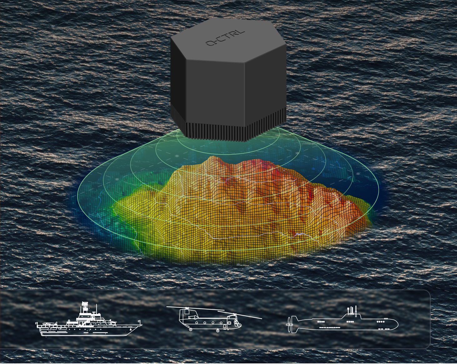
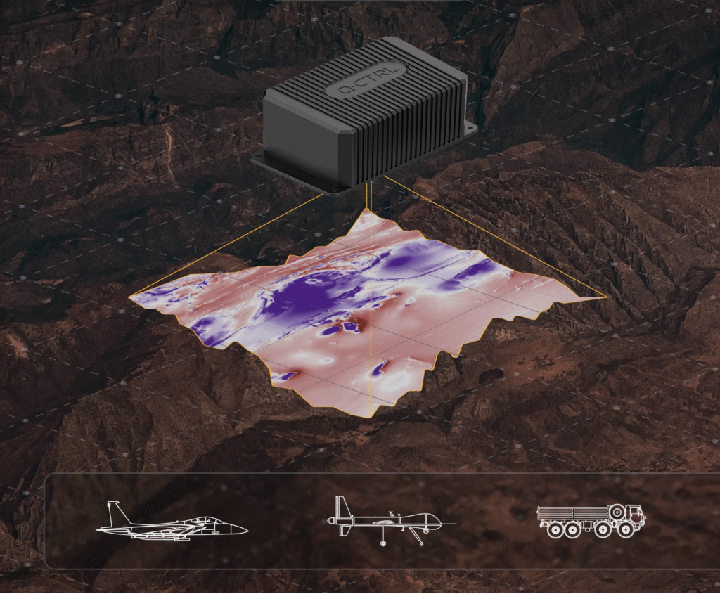
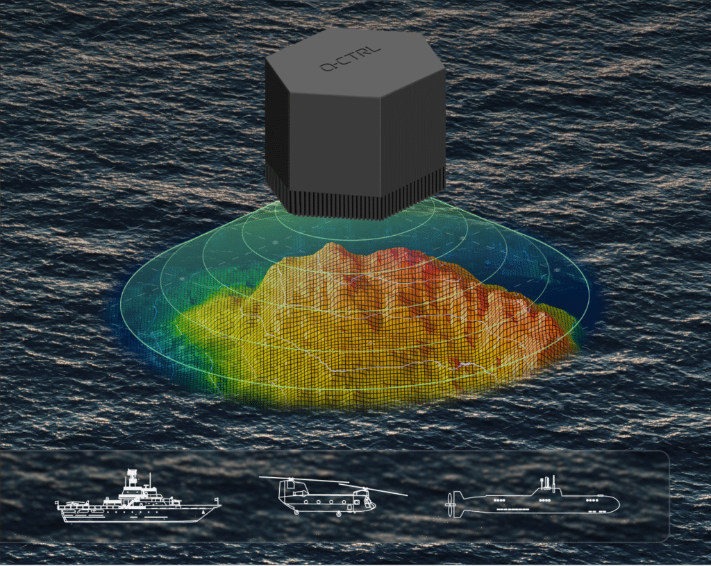
    Q-CTRL will develop next-generation quantum sensors for navigation based on their success in field trials of airborne, maritime, and ground-based quantum navigation augmented by their proprietary AI-powered software ruggedization. The technology enables sensors to operate reliably on moving defense platforms subject to challenging real-world conditions, without the need for traditional shielding or isolation.

    Q-CTRL will be joined by Lockheed Martin as a subcontractor on one aspect of the RoQS program, leveraging its expertise in GPS and quantum technology.

    Photo:
    Software-ruggedized quantum magnetometer. (Image: Q-CTRL)

    DARPA established RoQS to accelerate the development, testing and validation of quantum sensors for real-world defense applications, which include maintaining stability against environmental interference, mechanical vibrations and heavy g-forces. 

    Some sectors and organizations are fast-maturing quantum navigation for use on land, sea, in space, and in the air. The aerospace industry is actively exploring the potential for magnetic navigation technologies, with companies like aircraft manufacturer Airbus pursuing their development. 

    Additionally, Q-CTRL’s programs target the complementary missions of geophysical mapping of gravity and magnetic fields, as well as positioning based on matching detected signals to the pre-generated maps. This approach provides huge advantages in navigational missions and delivers new insights into minerals prospecting and underground target detection.

    Photo:
    Software-ruggedized quantum gravimeter. (Image: Q-CTRL)

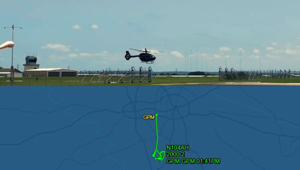
    Ironstone Opal, the company’s quantum-assured navigation system, recently outperformed a high-end inertial navigation system (INS) in flight for the first time, achieving up to 111x greater positioning accuracy when GPS was unavailable – a significant step forward for real-world applications of quantum sensing to defense missions. In these tests, the company’s proprietary AI-driven, software-level innovation was the key to the removal of platform interference.

    Ironstone Opal’s navigation system was also recently validated in maritime trials on board the Royal Australian Naval vessel, MV Sycamore.

    In March, Lockheed Martin and Q-CTRL were awarded a contract by the U.S. Department of Defense’s Innovation Unit to prototype a quantum-enabled inertial navigation system.

  • U-blox and Nordian expand PointPerfect Flex further in South America

    U-blox and Nordian expand PointPerfect Flex further in South America

    U-blox has expanded its partnership with Nordian to deliver its PointPerfect Flex (PPP-RTK) centimeter-level correction services across Argentina and Paraguay, building on existing coverage in Brazil as part of a broader regional expansion strategy.

    The PointPerfect Flex GNSS correction service addresses growing demand from South America’s agriculture sector, while also serving drone operators, surveying and mapping professionals. The expanded coverage delivers centimeter-level accuracy at scale without requiring deployment of additional local base station infrastructure, enabling agricultural solution providers to implement precision automation solutions across remote areas where traditional RTK networks are not economically viable.

    PointPerfect and u-blox GNSS receivers are developed in close conjunction with each other to achieve optimum results. The system supports both SPARTN data format optimized for u-blox receivers and RTCM format for non-u-blox GNSS RTK receivers, ensuring broad compatibility.

  • Airbus, Shield AI complete first autonomous logistics connector helicopter flight

    Airbus, Shield AI complete first autonomous logistics connector helicopter flight

    Airbus U.S. Space & Defense completed its first autonomous helicopter test flight using Shield AI’s Hivemind autonomy package in Grand Prairie, Texas. The flight represents a significant step forward in developing the MQ-72C Lakota Connector for the U.S. Marine Corps Aerial Logistics Connector program.

    The test utilized an H145 helicopter to refine mission technology, accelerate development timelines and reduce costs and technical risks. Engineers integrated Hivemind into the aircraft in less than two months, showcasing the system’s modular and platform-agnostic design.

    During the test, Shield AI’s Hivemind autonomy software controlled the H145 directly while collaborating with Airbus’ Helionix system. The integrated software managed the aircraft’s mission systems, executing automated takeoff, landing and other test procedures without pilot input.

    The tested software will be incorporated into the future MQ-72C helicopter design to meet Marine Corps requirements for the ALC program. The MQ-72C Logistics Connector is being developed as an unmanned version of the UH-72 Lakota, a multi-mission platform used across various operations.

    Shield AI‘s software expands the platform’s capabilities through autonomous operations across logistics and operational scenarios. Future test activities and demonstrations will scale the MQ-72C’s autonomy level, leading toward unmanned operations in contested logistics environments.

    Airbus U.S. plans to apply mission autonomy software to add autonomous capabilities to other helicopter variants beyond the MQ-72C. The company is in the second year of the Aerial Logistics Connector Middle Tier of Acquisition Rapid Prototyping Program, which provides aircraft prototypes for operational demonstrations and experiments.

    In May 2024, Naval Air Systems Command awarded Airbus U.S. Space & Defense a Phase I Other Transaction Authority through the Naval Aviation Systems Consortium for its unmanned UH-72 Logistics Connector concept.

    The Aerial Logistics Connector initiative is among several Defense Department programs designed to deliver logistical support in distributed environments during conflicts with peer or near-peer adversaries.

  • Rohde & Schwarz demonstrates counter-drone technology at Defense Expo

    Rohde & Schwarz demonstrates counter-drone technology at Defense Expo

    Rohde & Schwarz has demonstrated its latest advancements in counter-drone technology at CUAS Expo 2025 at Thorney Island. The display featured an integrated system that included the ARDRONIS Wi-Fi detection solution and ARDRONIS Locate Advanced localization solution, along with the newly released ARDRONIS Effect configured as a multiband jammer.

    At the event, Rohde & Schwarz showcased how its comprehensive counter-drone system detects, identifies and neutralizes rogue drones regardless of their operating frequency. The demonstration showed the system’s ability to manage non-cooperative and non-compliant devices operating outside established regulations.

    ARDRONIS Effect in the Multiband Jammer configuration was a key highlight, demonstrating its unique wideband architecture which enables it to simultaneously jam multiple frequency bands, providing unparalleled protection against a diverse range of drone threats. Unlike traditional jamming solutions, ARDRONIS Effect in the Multiband Jammer configuration doesn’t rely on pre-defined frequencies, making it highly effective against drones operating on unconventional or rapidly changing frequencies.

    ARDRONIS Locate Advanced complemented the jammer by providing precise drone detection and localization, allowing attendees to witness the system’s ability to quickly identify the location of drones and enable informed response decisions. The integrated system delivered a comprehensive view of situational awareness and robust protection capabilities.

    Rohde & Schwarz said it received interest from attendees at CUAS Expo 2025 and had conversations about customer requirements. The company is following up with agencies and CUAS system integrators to discuss potential deployments of the ARDRONIS system.

    “Discussions with attendees underscored the growing concern surrounding non-compliant drone activity and the need for adaptable, wideband solutions like ours,” said Christopher Mantle, business development manager for UK Land EW and Communications at Rohde & Schwarz.

  • Australian Defence selects Adtran optical cesium clock for PNT research

    Australian Defence selects Adtran optical cesium clock for PNT research

    Australia’s Defence Science and Technology Group (DSTG), part of the Australian government’s Department of Defence, has selected Adtran’s Oscilloquartz high-performance optically pumped cesium clock to support research at its Adelaide facility.

    The OSA 3300 HP will serve as a time and frequency reference for positioning, navigation and timing (PNT) research. Delivered in collaboration with local partner CoverTel, the deployment marks the first integration of optical cesium technology within Australian defense research.

    “DSTG’s selection of our optical cesium reflects a broader shift toward autonomous, long-term synchronization solutions,” said Stuart Broome, GM of EMEA and APAC sales at Adtran. “Defense organizations around the world are reassessing how they ensure timing resilience, particularly as reliance on GNSS becomes more of a risk.”

    The OSA 3300 HP will give national infrastructure precision and adaptability, supporting DSTG’s research into new strategies for assured PNT. DSTG selected the OSA 3300 HP to support advanced PNT research within its Sensors and Effectors division.

    Using optical pumping technology that measures 100 times more atoms than traditional magnetic cesium clocks, the device delivers outstanding frequency stability and precision, Adtran said. Its all-digital design ensures consistent performance, while its 10-year operational lifespan offers long-term value.

    With its compact form factor, robust construction and advanced atomic technology, the OSA 3300 HP provides the reliability needed to support Australia’s evolving synchronization requirements and critical scientific initiatives.

    The clock will help DSTG explore new approaches to synchronization and build greater resilience into the Australian Defence Force’s long-term PNT capabilities, especially in contested environments where GNSS jamming and spoofing are prevalent. It will lay the groundwork for systems that rely on precise, dependable timing — from secure defense communications to advanced sensing and navigation.

  • Ghana launches nationwide CORS network exercise

    Ghana launches nationwide CORS network exercise

    Ghana Lands Commission, through its Survey and Mapping Division (SMD), in collaboration with the Licensed Surveyors Association of Ghana (LiSAG) and GMX Systems Ghana Limited, has launched a nationwide observation exercise for Ghana’s GNSS Continuously Operating Reference Station (CORS) Network.

    This initiative is a major milestone in modernizing the country’s geospatial infrastructure and improving land administration.

    The exercise aims to integrate more than 60 newly established CORS stations into the national geodetic framework, consolidating Ghana’s Grid Coordinate System. The partners plan to expand the network to 100 stations before the end of the year.

    With a modern CORS network, surveyors and spatial data users will have 24/7 access to high-precision data, improved efficiency and cost savings, while aligning Ghana with international geospatial standards.

    It will improve accuracy for land records, agriculture, disaster management, infrastructure development, and revenue generation for the Lands Commission. The observation will be rolled out in three phases — Southern, Middle, and Northern zones — to ensure systematic coverage and data management.

  • Swift Navigation, Taiwan Mobile advance centimeter-accurate positioning for autonomy

    Swift Navigation, Taiwan Mobile advance centimeter-accurate positioning for autonomy

    Swift Navigation has partnered with Taiwan Mobile, a major telecommunications company in Taiwan, to introduce the Skylark Precise Positioning Service to the Taiwanese market. This collaboration aims to meet the increasing demand for high-accuracy positioning solutions across various industries.

    Skylark is a real-time GNSS correction service that enhances positioning precision to the centimeter level by correcting signal errors from GNSS. It is the first cloud-based precise positioning service developed specifically for large-scale applications, designed to deliver accuracy, reliability, and safety worldwide. The service utilizes advanced atmospheric modeling to reduce errors from ionospheric disturbances, clock drift and satellite orbit inaccuracies, improving location accuracy from several meters to just a few centimeters.

    The service is supported by a carrier-grade network consisting of modern ground reference stations, which have been designed and operated collaboratively by Taiwan Mobile and other mobile network operators globally. Skylark’s highly reliable and precise positioning capabilities are expected to support emerging applications in automotive, robotics, and fleet management sectors. In automotive applications, it is the first and only automotive safety integrity level (ASIL) certified, real-time cloud-based positioning service compliant with ISO 26262:2018, enabling safe operation of advanced driver-assistance systems (ADAS) and autonomous vehicles.

    For robotics, Skylark’s proprietary atmospheric modeling offers centimeter-level accuracy with extended baselines and automatic failover, ensuring reliable performance for devices such as robotic lawnmowers and surveying drones. In fleet management, the service provides a cost-effective, dependable positioning solution optimized for battery-powered devices, facilitating efficient last-mile and final-inch logistics, and integrating with a broad range of compatible GNSS hardware.

  • Trimble introduces RTX-NMA to combat GNSS spoofing

    Trimble introduces RTX-NMA to combat GNSS spoofing

    GNSS spoofing has become a regular occurrence with the potential for severe consequences when precise and reliable positioning is critical. Legacy GNSS signals are the primary target for bad actors, as most precise positioning relies on these signals, and it’s constantly getting easier and cheaper for people to fake the message. To combat this, Trimble has introduced Trimble RTX-NMA (Navigation Message Authentication), the first solution on the market to mitigate spoofing attacks on the GPS and BeiDou satellite constellations. Trimble RTX-NMA leverages the Trimble RTX correction service and enhances the security and integrity of GNSS navigation messages for all Trimble ProPoint receivers. Used in conjunction with Galileo OSNMA, users now have three constellations protected from spoofing attacks.   

    Trimble RTX-NMA seeks to detect both fake GNSS signals and faulty ephemeris data through real-time authentication that ensures navigation messages from multiple RTX reference station receivers are genuine and trustworthy. It also encompasses faulty ephemeris detection, preventing unreliable data from being included in the correction stream. Enhanced security through advanced cryptographic techniques like AES encryption, and stream authentication, take it a step further. Trimble RTX-NMA is also compatible with various Trimble GNSS receivers using firmware version 6.40 or greater, making it a versatile solution for a wide range of applications without a subscription. With these features, Trimble RTX-NMA offers increased reliability, enhanced security, and improved integrity — an added layer of defense against potential threats such as spoofing.

    As reliance on GNSS continues to grow, ensuring the security and integrity of navigation data becomes paramount. Trimble RTX-NMA represents a significant step forward in addressing these challenges, offering a robust and effective solution for enhancing GNSS security. 

  • JAVAD GNSS, Inertial Labs partner to deliver advanced GNSS+INS navigation platform

    JAVAD GNSS, Inertial Labs partner to deliver advanced GNSS+INS navigation platform

    JAVAD GNSS, a global provider of high-precision GNSS solutions, and Inertial Labs, a VIAVI Solutions Company, have entered a strategic partnership to integrate Inertial Labs’ IMU-P modules with JAVAD’s advanced OEM GNSS receivers. This collaboration introduces a new GNSS+INS platform designed to deliver accuracy, stability and resilience, even in environments where GNSS signals are weak or unavailable.

    Central to this advancement is the JAVAD TR-3Si receiver, engineered for compatibility with professional IMU modules. Combined with the advanced IMU-P units, the system is positioned to offer high levels of precision and reliability, supporting mission-critical requirements in aerospace, defense, autonomous vehicles, UAVs, robotics, precision agriculture and other demanding sectors.

    Inertial Labs’ IMU-P modules can perform in dynamic settings, providing continuous orientation and acceleration data for sensor fusion. The integration of this inertial technology with JAVAD’s established GNSS systems enhances navigation accuracy and efficiency in both GNSS-accessible and GNSS-denied environments.

    JAVAD GNSS is expanding its support for IMU modules and is expected to release further updates on this initiative.

  • DAF launches NTS-3 Vanguard on ULA Vulcan Rocket

    DAF launches NTS-3 Vanguard on ULA Vulcan Rocket

    The Department of the Air Force (DAF) has successfully launched the Navigation Technology Satellite-3 (NTS-3) Vanguard aboard the United Launch Alliance (ULA) Vulcan rocket on the USSF-106 mission from Cape Canaveral Space Force Station, Florida, on August 12, 2025. This mission marks the first U.S. national security payload launched on the Vulcan Centaur rocket, which represents a new era of launch vehicle capability for national defense.

    “We have a strategic imperative to deliver science and technology that enables and accelerates a resilient hybrid space architecture for the space capabilities that the joint force depends on,” said Air Force Research Laboratory (AFRL) Commander and DAF Technology Executive Officer (TEO), Brig. Gen. Jason E. Bartolomei.

    NTS-3’s Advanced Architecture

    NTS-3 is an experimental integrated navigation satellite designed by the AFRL to enhance the robustness, resilience and responsiveness of space-based positioning, navigation and timing (PNT) services, crucial to both military and civilian applications. The satellite aims to advance the capabilities of existing global navigation satellite systems, such as GPS, through innovative technology that includes an advanced atomic clock timekeeping system, a reprogrammable receiver compatible with both legacy and advanced signals (the Global Navigation Satellite System Test Architecture), and Chips Message Robust Authentication, which defends against GPS spoofing.

    NTS-3 features a fully reprogrammable software architecture that spans the space-based satellite, ground-based control system, and agile user receivers. This enables rapid software updates either on orbit or in the field, a significant departure from previous GPS satellites that required hardware changes for upgrades. This approach delivers not only military advantages in contested environments but also substantial benefits for civilian users who rely heavily on GPS for banking, agriculture, telecommunications and air traffic control.

    “We rely on GPS so much, in ways that we don’t always think about,” said Rachel Gleichmann, NTS-3 deputy program manager, AFRL Space Vehicles Directorate. So, to make sure that it is resilient and that it’s always available and always accurate — or, as the military likes to say, ‘assured’ is extremely important to your average American.”

    Industry partner L3Harris Technologies serves as the prime contractor, working alongside AFRL on the design, development, integration, testing, launch vehicle interface, and on-orbit operations of the satellite. The collaboration embodies a comprehensive ecosystem approach that leverages resources from government, industry, academia, and venture capital to foster innovation in national security space.

    For more information on AFRL’s NTS-3 program, visit the Air Force Research Laboratory website.

  • Anduril enters South Korean market, partners with Korean Air on UAS production

    Anduril enters South Korean market, partners with Korean Air on UAS production

    Anduril Industries is expanding into South Korea, opening a new office in Seoul. The company has also appointed a new local country leader and is forming partnerships with Korean companies to develop defense technologies for the region.

    The move coincides with a two-day visit to the Republic of Korea by company founder Palmer Luckey, who is meeting with government officials and industry leaders.

    The Seoul office is Anduril’s first in South Korea. John Kim has been appointed vice president and head of Anduril Korea. Kim previously led Boeing Korea’s defense business and served as the company’s interim president. He brings extensive experience working with the U.S. military and South Korea’s defense sector. The company plans to expand its local team and expects to double its headcount within 12 months.

    South Korea’s Ministry of Defense has prioritized artificial intelligence, autonomous systems, and networked weapons as part of a modernization effort coordinated by the Joint Chiefs of Staff. Military planners say current defense systems are insufficient to deter or prevail in future conflicts.

    As part of the expansion, Anduril will sign a contract with Korean Air’s Aerospace Business Division to co-develop unmanned aerial systems, license production of additional Anduril products for the Indo-Pacific market and explore the possibility of building a manufacturing and production facility in South Korea. The agreement is expected to establish a cooperative defense technology framework in the region.

    “Anduril is committed to helping the Republic of Korea in its mission to develop a technologically advanced, highly networked armed force with fewer but more precise platforms,” Kim said. “Our new office and team expansion is further demonstration of this ongoing commitment.”

    Founded in 2017, Anduril employs more than 6,000 people and is valued at over $30 billion. The company has delivered advanced defense capabilities to the U.S. Department of Defense, the Australian Defence Force and the U.K. Ministry of Defence. The new Seoul office will expand Anduril’s growing footprint in the Indo-Pacific.

  • Russian electronic warfare base linked to GPS jamming across Baltic region

    Russian electronic warfare base linked to GPS jamming across Baltic region

    The Estonian news portal Delfi reports that a covert Russian military installation in the Królewiec region, just east of Poland’s border, is believed to be responsible for GPS interference affecting the Baltic states and the Gulf of Finland.

    According to confidential sources, the facility’s primary mission is to monitor satellites and NATO communications, with the goal of undermining allied intelligence operations. Documents obtained by Delfi indicate that the base, located in Pioniersk, is part of Russia’s “Tobol” electronic warfare network.

    The Tobol system is described as a network of surveillance, defense and command sites designed both to shield Russian satellite communications and navigation systems from NATO attacks and to disrupt NATO intelligence. The Królewiec facility, which focuses on satellite monitoring, was officially established in 2009 by the Russian Ministry of Defence. Similar installations are located across Russia, including near Moscow, Penza, Cheboksary and in Ulan-Ude, Siberia.

    In July, Estonian authorities detected new jamming equipment near the eastern border by Narva and along the Narew Gulf coast. Experts believe these measures are intended to protect Russian facilities from potential Ukrainian drone strikes.

    The Finnish newspaper Ilta-Sanomat, reports that Russia has been developing navigation jamming technology since the 1980s, initially as a counter to GPS-guided weapons. Those capabilities have since expanded in response to Western military equipment supplied to Ukraine.

    Since the start of Russia’s full-scale invasion of Ukraine in 2022, incidents of GPS interference have increased in countries bordering Russia. Aviation and maritime navigation have been particularly affected, with pilots and ship crews reporting inaccurate or lost positioning data.