Xona has reached three new commercial agreements with precision timing innovators Hoptroff, Fibrolan and Timebeat, marking its official entry into the precision timekeeping and synchronization market. These partnerships seek to enable end users to leverage Xona’s Pulsar satellites to provide independent, secure, and resilient timing infrastructure amid mounting global complexity and risk.
Satellite navigation provides far more than positioning — it’s the world’s most accurate source of globally synchronized time signals underpinning nearly every critical system, including:
Emergency response coordination
Real-time power grid balancing
Transportation network resilience
Fair and trustworthy global financial trading
5G network synchronization
Data center efficiency and security
As infrastructure becomes more connected and distributed, timing is the backbone of data governance— determining who holds critical data, when it was held and for how long. A single second lost or spoofed can erode trust across every facet of daily life.
Broadcasting nanosecond-level accurate time from low-Earth orbit, Pulsar provides a new alternative to vulnerable GNSS-based systems. With built-in authentication, secure signals, and up to 100x received power of legacy GNSS, Pulsar ensures reliable reception even in low-rise buildings and urban environments — all without requiring specialized hardware, according to the company.
“This is an important milestone — proof that next-generation satellite technology is no longer just promising innovation, but solving real, urgent problems today.” said Jay Wakenshaw, COO of Xona. “Seeing market leaders like Hoptroff, Fibrolan, and TimeBeat adopt Pulsar validates that there’s a genuine need and significant demand for what we’re bringing to market.”
Pulsar testing and demonstrations in real-world environments will continue through this year and into early next year, with active field deployments planned from late 2026.
“Our customers in critical national infrastructure rely on precision timing to keep their operations secure, compliant, and efficient.” said Tim Richards, CEO of Hoptroff. “The low-Earth orbit Ssatellite system provided by Xona will add additional redundancy to our global timing network, and complements our existing terrestrial timing infrastructure which is essential for next gen applications particularly in these uncertain times.”
“We’re always seeking innovative alternatives to GNSS — because the future of timing depends on it.” said Shamir Stein, CEO of Fibrolan. “Pulsar is exactly the kind of breakthrough our industry needs: a powerful, dependable solution that will allow us to continue delivering simple, robust, and hassle-free timing to our partners and customers.”
Hexagon’s surveying solutions are playing a key role in the construction of Project Rogfast, a 27-km subsea road tunnel in Norway that is set to be the longest and deepest of its kind. Running 392 m below sea level, the tunnel will link Stavanger, Haugesund and Bergen, aiming to cut travel time by up to 50% and strengthening economic connections in the oil and gas sector.
The project, led by construction firm Skanska, presents unique engineering challenges, including tunneling from both ends with a final meeting point that allows for no more than a 5 cm margin of error. Even small misalignments could result in significant delays and costly rework. Skanska is using Hexagon’s portfolio of Leica Geosystems solutions to align machinery and validate measurements in real time, enabling precise tunneling under extreme conditions.
Hexagon’s technologies are delivering measurable impact across the project by:
Enabling precise alignment with total stations, GPS, multistations and laser scanners.
Reducing rework, emissions, and cost through real-time data capture and validation.
Powering safe operations under extreme conditions, 392 m below sea level.
“In a project like this, even a millimeter of misalignment can trigger cascading risks,” said Trond Valleur, vice president at Skanska. “Hexagon’s technology gives our teams the confidence to move forward with accuracy, efficiency and safety.”
The Leica Nova MS60 MultiStation is a robotic total station that can measure points down to 1 mm to 2 mm and capture 3D scans. (Credit: Hexagon)
The collaboration reflects a partnership between Skanska and Hexagon that has spanned more than 30 years. The Skanska team is using several Leica Geosystems surveying instruments, including the Leica RTC360, Leica MS60 MultiStation, Leica AP20 AutoPole and Leica TS60.
The GöKHUN unmanned aerial system (UAS) from Turkish company ESEN is a tactical vertical take-off and landing (VTOL) drone system that does not require a runway, offering maximum flexibility in operational use.
Developed for versatile missions on land or at sea, GöKHUN combines the compact mobility of a NATO Class I UAV with the performance data of a Class II tactical system. The GöKHUN UAS uses the modern SP 210 FI GS 2-stroke engine from Sky Power International.
With a take-off weight of up to 110 kg and a maximum fuel and payload capacity of 26 kg, the GöKHUN can remain in the air for up to 16 hours with a minimum payload. Even with a demanding sensor load of 12 kg, it can achieve a flight duration of around nine hours, making it suitable for long-endurance reconnaissance and surveillance missions.
The GöKHUN’s cruising speed is between 96 and 158 km/h. The maximum range with direct line-of-sight is over 150 km, with the system reaching a service ceiling of approximately 5,500 m.
GöKHUN can take off and land in an area measuring 10 x 10 meters, regardless of topographical conditions and without any infrastructure. This also allows it to be deployed in remote or difficult-to-access regions and on ships.
The GöKHUN was designed for complex intelligence, surveillance and reconnaissance (ISR) missions. In addition, the system is suitable for a wide range of other applications such as environmental monitoring, disaster relief, border surveillance, anti-smuggling operations and precision agriculture. With its integrated vision-based navigation system GöRDES, the drone is independent of GNSS signals and can be reliably controlled even in GPS-denied environments.
All safety-relevant systems such as navigation, flight control, data transmission and power supply are designed with double or triple redundancy. If the connection to the ground station is lost, the UAV returns autonomously to its starting point. In addition, GNSS interference protection ensures robust operation even under electronic interference.
The GöKHUN is also designed for mobility and speed. Two technicians can have the system up and run in around 15 minutes, and it can be transported in two standard vehicles. Thanks to its modular design, the system is easy to maintain and can also be easily adapted to different deployment scenarios. A particularly outstanding feature is its ability to operate two different payloads simultaneously, for example EO/IR sensors for day and night operation or different communication and reconnaissance systems. It is controlled via an integrated ground station with a data terminal, which can also be transferred to other carrier vehicles during an operation.
The system’s high environmental resistance, with an operating temperature range of −30°C to +55°C, and its ability to fly stably at wind speeds of up to 40 knots underlines its robustness. With its ITAR-free design, GöKHUN meets international export requirements and complies with NATO standards AEP-83/84. The system can be easily integrated into existing tactical networks, making it attractive to international partners.
Overall, GöKHUN combines tactical range, modular architecture, simple logistics and operational independence. With its high endurance, vertical take-off capability and safe mission execution in complex environments, the system is ideal for modern applications in security-critical but also in civil areas, whether for border surveillance, disaster relief or as an ISR platform at sea. Its independence from GNSS signals and flexible payload configuration make the GöKHUN UAS a state-of-the-art solution in the field of unmanned aerial reconnaissance.
STM unveiled two of its latest innovations at IDEF 2025: the BOYGA-B rotary-wing UAV, capable of carrying multiple munitions, and the TUNGA Smart Munition System. IDEF, the International Defense Industry Fair, is a globally recognized trade fair in the defense industry, ths year hosted by Türkiye in Istanbul July 22-27.
The BOYGA-B Ammunition Drop UAV is engineered for tactical missions such as reconnaissance, surveillance, target detection and precision munition deployment. The system can carry smart munitions as well as two 81 mm UAV munitions.
The TUNGA Smart Munition System, developed for anti-personnel missions, has a modular design, image-based or GNSS-based guidance, and proximity-fuze detonation capability. Both new systems are designed to meet the evolving needs of modern combat environments.
BOYGA-B Ammunition Drop UAV
BOYGA-B is a high-precision rotary-wing UAV designed for reconnaissance, surveillance, target engagement and precision munition deployment in tactical operations. It can operate in GNSS-denied or jammed environments with its CRPA antenna and KERKES integration. The system can carry up to 8 kg of munitions and precisely release them onto targets using its integrated drop mechanism.
Key Features
GNSS-denied operation via CRPA and KERKES
Flight time: 35 minutes
Range: Minimum 5 km
Operable by a single soldier
Target detection and tracking
Real-time EO/IR image transmission
Autonomous munition release and mission abort
Payload Options
2× 81 mm UAV Munitions
1× TUNGA Smart Munition
1× Kargu FPV Drone
TUNGA Smart Munition System
TUNGA is a glide-type guided munition developed by STM for anti-personnel missions. Equipped with a 1750 g warhead, TUNGA can be precisely guided to its target using EO/thermal imaging and onboard image processing. It offers safe operation with self-destruct functions and can be deployed from BOYGA-B or other compatible platforms.
Javad GNSS has released its latest data collection software, Javad Data Collector (JDC). Designed to run seamlessly on any Android device, JDC interfaces effortlessly with the company’s modern line of smart antennas.
JDC features simple, intuitive workflows that require minimal training, making it accessible for users of all skill levels. The software includes a Signal Bar for a quick view of receiver status, ensuring users can easily monitor their equipment’s performance. Additionally, JDC offers easy navigation, allowing users to move through the software with efficiency.
“Our goal with JDC was to create a tool that not only meets but exceeds the needs of our diverse clientele,” said Gary Walker, executive vice president, JAVAD GNSS. “We understand the demands of the full spectrum ranging from the individual surveyor to larger surveying firms, construction and engineering firms, as well as government entities. JDC is designed to streamline their operations, making it easier to deploy and manage receivers across teams of any size with minimal training.”
JDC is available for download through the company’s official website. Customers can evaluate the full functionality of JDC with limited point storage and may request a license when ready to integrate it into their workflow.
On July 23, 2025, the National Geodetic Survey (NGS) sent a news notice announcing the rollout plan for remaining NSRS modernization products, including OPUS Products Changes, and on June 11, 2025, they sent a news notice to users stating that NGS’s Multi-Year CORS Solution 3 (MYCS3) was released. This newsletter will highlight these two News notices and what they mean to users of the United States National Spatial Reference System (NSRS).
A colleague recently reminded me that the new NSRS is more than just a technical update — it presents an ideal opportunity to review existing processes and workflows, address current products and process considerations, and strategically plan for future requirements. It is well known that the new NSRS will significantly improve geospatial data accuracy. Improved accuracy and reliability of geospatial data empower management to make more informed decisions and optimize resource allocation. NSRS users should proactively assess their geospatial data dependencies and evaluate how adoption of the new datum will affect workflows, datasets and operational decision‑making. I will provide you with more information at a later date.
NGS NEWS
Rollout Plan for Remaining NSRS Modernization products, including OPUS Products Changes
On June 17, 2025, NGS released the first preliminary products of the modernized National Spatial Reference System (NSRS) for beta testing and feedback. In the coming months, additional products listed below will be made available. As each product is released, it will undergo at least six months of testing preceding the final adoption and implementation of the modernized NSRS.
The descriptions below supersede previous updates or information shared in NSRS Modernization blueprint documents, plans, or presentations. These products and their status will be described on the Track Our Progress webpage.
The Data Delivery System (DDS) landing page will provide an updated version of the “NGS Map” and “Looking for Benchmarks” pages. This new landing page will allow you to access modernized informational pages about geodetic stations and geodetic marks.
Geodetic station pages will offer an updated version of the current NOAA CORS Network (NCN) station pages. Geodetic mark pages will be updated datasheets, replacing the current ASCII text file version of datasheets. The updated coordinates (reference epoch coordinates) for marks and updated CORS coordinate functions (CCFs) for CORSs in the modernized NSRS will be available through these pages.
The NGS Coordinate Conversion and Transformation Tool (NCAT) will be updated through multiple versions, currently with state plane coordinates, then later adding support for various geopotential calculations including ellipsoid/orthometric height conversion as well as NADCON (geometric) and VERTCON (orthometric) transformations from the current NSRS to the modernized NSRS.
OPUS-Static will function similarly to today’s tool, but it will operate with the modernized NSRS, including the support of multi-GNSS data. Additionally, the popular function of “sharing” your solution with others (colloquially called “OPUS-Share”) will be retained, but with appropriate caveats that the shared solution should not be used as geodetic control. These shared solutions will be available through the geodetic mark pages of the DDS.
The following products will not be included in the release of the modernized NSRS. However, plans to replace the services or mitigate gaps are described below.
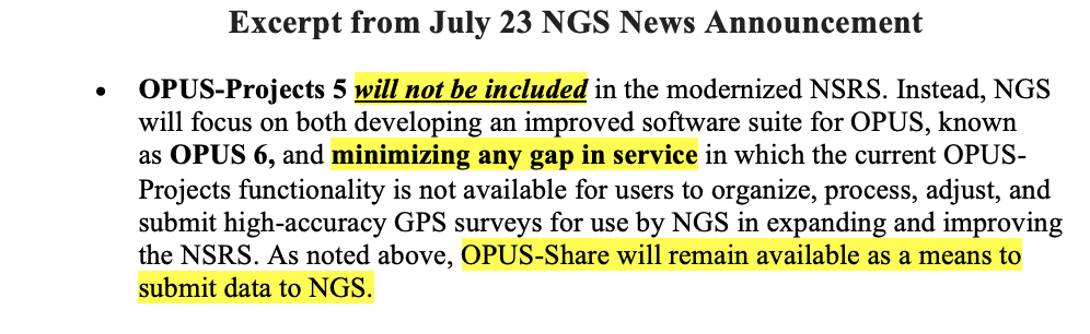
OPUS-Projects 5 will not be included in the modernized NSRS. Instead, NGS will focus on both developing an improved software suite for OPUS, known as OPUS 6, and minimizing any gap in service in which the current OPUS-Projects functionality is not available for users to organize, process, adjust, and submit high-accuracy GPS surveys for use by NGS in expanding and improving the NSRS. As noted above, OPUS-Share will remain available as a means to submit data to NGS.
OPUS-Rapid Static (OPUS-RS) will not be included in the modernized NSRS. Instead, the modernized version of OPUS-Static, noted above, will be capable of processing multi-GNSS static data files that are shorter in duration (i.e., less than 2 hours).
Note: the current OPUS Projects 5 software will be supported until the modernized system is adopted, and a deadline for OPUS-Projects users to submit their surveys for publication will be announced with at least six months’ notice.
To stay informed about these releases, please subscribe to NGS News. If you have questions, please email [email protected].
Now, I would like to address the issues associated with July 23, 2025, announcement. This NGS News announced the rollout plan for the remaining NSRS modernization products. I have highlighted several sentences in this announcement that I believe users need to understand to determine the impact on their processes and workflows that are used to generate their products and services.
The news announcement states that NGS released the first preliminary products of the modernized National Spatial Reference System (NSRS) for beta testing and feedback. My July 2025 GPS World Newsletter highlighted these preliminary products. It mentioned that in the coming months, additional products will be made available. Each product will undergo at least six months of testing preceding the final adoption and implementation of the modernized NSRS. This seems to be a good process, but users need to understand the complete message.
The NGS News announcement provides a list of products that will be available and a list of products that will not be available when the new NSRS is adopted. Users need to understand what products will not be available after NGS officially adopts the new NSRS so they can determine what that means to their workflow process and client requirements. In my opinion, for the new NSRS to be successfully implemented by users, it is essential that all the necessary software tools are available to enable users to submit projects for review, approval, and publication by NGS. As many of you know, when I worked for NGS, I was the Project Manager of the North American Vertical Datum of 1988 (NAVD 88). That said, from my experience as the NAVD 88 Project Manager, having the appropriate tools available was important for users to implement NAVD 88. As a matter of fact, NGS accepted and processed vertical control data in both NGVD 29 and NAVD 88 for a period to assist users in the implementation of the new vertical reference datum.
It is important to note that the NGS News Announcement states that OPUS-Project 5 will not be included in the new NSRS when it is officially adopted. See the below image.
Since OPUS Projects 5 will not be supported after the modernized system is adopted, users will not be able to submit their projects for review, approval, and publication by NGS like they can do today. NGS does indicate that they will be working on OPUS 6 to “minimize any gap in service.” There are a few questions that I believe should be addressed: (1) What does “minimize any gap in service” mean? Is this one month, one year, or several years? (2) Why must the new NSRS be adopted before users can submit their projects to NGS for official publication? And (3) Why should users use OPUS-Share when NGS itself advises against relying on OPUS-Share results for establishing geodetic control? If the federal agencies and surveying community allow the new NSRS to be adopted before OPUS 6 is available or OPUS Project 5 is modified for use in the new NSRS, the only way to get an updated coordinate such as NATRF2022 and NAPGD2022 using NGS process will be to use NGS OPUS-Share products. Again, NGS states that OPUS-Share results should not be used as geodetic control. See NGS’ statement on OPUS Share below.
This is NGS’s statement on OPUS-Share: Additionally, the popular function of “sharing” your solution with others (colloquially called “OPUS-Share”) will be retained, but with appropriate caveats that the shared solution should not be used as geodetic control. These shared solutions will be available through the geodetic mark pages of the DDS.
Using OPUS-Share results that are NOT official NSRS coordinates published by NGS could lead to confusing results and potential lawsuits since NGS does not stand behind the results and recommends NOT using OPUS-Share results for geodetic control. Why would users use OPUS-Share to establish geodetic control when NGS itself advises against relying on OPUS-Share for establishing geodetic control? OPUS-Share results are not officially submitted to NGS for review, approval, and publication on an NGS Datasheet. I don’t believe this approach will meet the needs of users who require their projects to be reviewed, approved, and published by NGS. What is your opinion? You should let NGS, and others know your thoughts and concerns about NGS’s rollout plan for remaining NSRS modernization products.
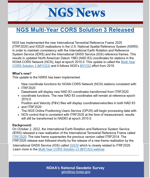
Now for the release of NGS’s Multi-Year CORS Solution 3 (MYCS3).
NGS MYCS 3 released (Credit: NGS)
First, why did NGS perform the NGS Multi-Year CORS Solution 3 (MYCS3)? To maintain consistency with the International Earth Rotation and Reference System Service (IERS) and the International GNSS Service (IGS) reference frames, NGS has implemented the new International Terrestrial Reference Frame 2020 (ITRF2020) and IGS20 realizations in the U.S. NOAA CORS Network (NCN). What this means to NSRS users is that NGS has updated the North American Datum 1983 (NAD 83), epoch 2010.0 coordinates for stations in the NOAA CORS Network (NCN). This update is called the Multi-Year CORS Solution 3 (MYCS3).
In summary, the MYCS3 news notice states the following:
The coordinate functions for NOAA CORS Network (NCN) stations are now consistent with ITRF2020,
NGS datasheets will display the new NAD 83 coordinates transformed from ITRF2020 coordinate functions,
The new NAD 83 coordinates will be referenced to NAD 83 2011 (epoch 2010.0),
Position and velocity files will display coordinates/velocities in both NAD 83 and ITRF2020, and
The NGS Online Positioning Users Service (OPUS) will begin processing data with NCN control that is consistent with ITRF2020 at the time of measurement; and the results will still be transformed to NAD 83 2011, epoch 2010.0.
The first question that everyone asks is, what are the changes to the coordinates in my region? And, of course, why was it necessary to do this update now, but that’s a discussion for another day. I downloaded the data and prepared a few plots and a table to depict the differences between the new and old coordinates. First, it should be noted that the old NCN coordinates were published in ITRF 2014, epoch 2010.0, and the new NCN coordinates are published in ITRF 2020, epoch 2020.0. So, there will be differences in coordinates because of updates between ITRF2014 and ITRF2020, and because the CORS ITRF 2020 coordinates are published at epoch 2020.0 instead of 2010.0.
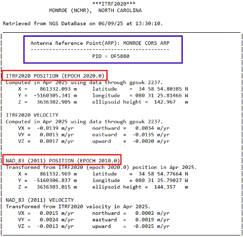
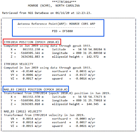
The image below provides the new and old CORS coordinates and velocity information for NOAA CORS Monroe (NCMR). These values can be obtained from NGS CORS website.
ITRF coordinates for NCMR. (Credit: NGS)
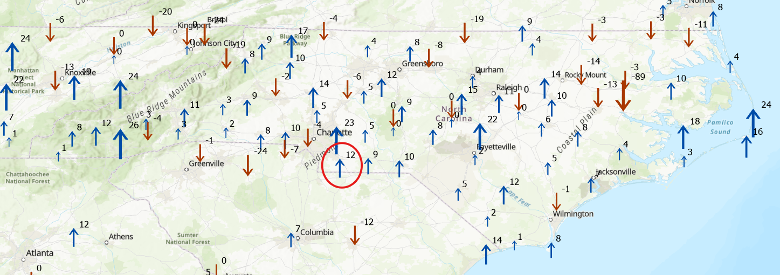
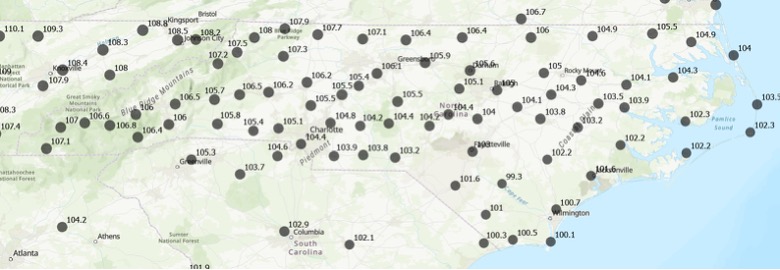
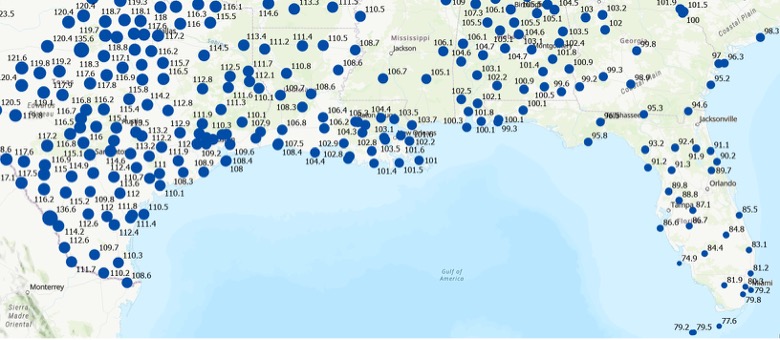
The difference between ellipsoid heights is straightforward. In the example, the difference is 144.357 meters minus 144.345 meters or 0.012 m. The image captioned “Change in Ellipsoid Height in NC based on ITRF 2020” provides the differences between MYCS3 and MYCS2 NAD83 2011, epoch 2010.0 published ellipsoid heights for the CORS in North Carolina. In other words, this is the change in the NAD 83 2011, epoch 2010.0 ellipsoid height at the CORS after updating to ITRF2020, epoch 2020. I’ve highlighted the NCMR CORS in the box. As you can see from the plot, there are several CORS in North Carolina that their ellipsoid heights have changed significantly; that is, greater than 20 mm and as large as -89 mm.
Change in Ellipsoid Height in NC based on ITRF 2020 (units in mm).
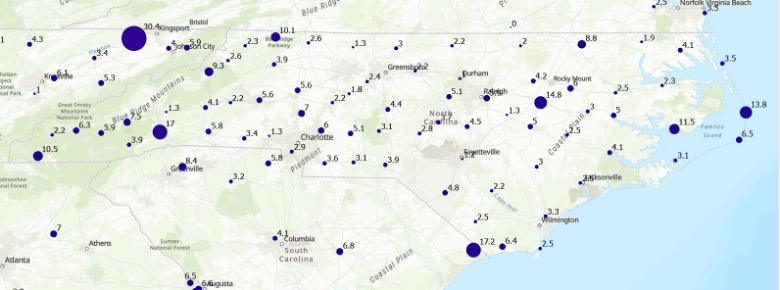
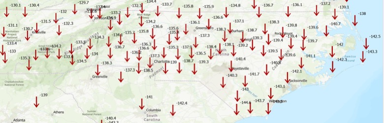
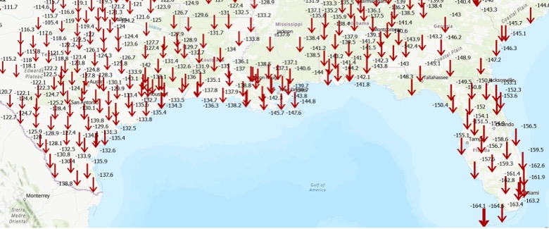
I don’t know about you, but I can’t determine the change in coordinates by looking at XYZ or Latitude/Longitude values. For the horizontal change I computed the differences in latitude and longitude and converted the results to millimeters. As indicated in the image above, the changes in the horizontal component are typically small; that is, less than a few mm. There are, however, a few larger changes such as the one at CORS TN1B (which is in Tennessee) that changed 30 mm.
Change in Horizontal Coordinates in NC based on ITRF 2020 (units mm).
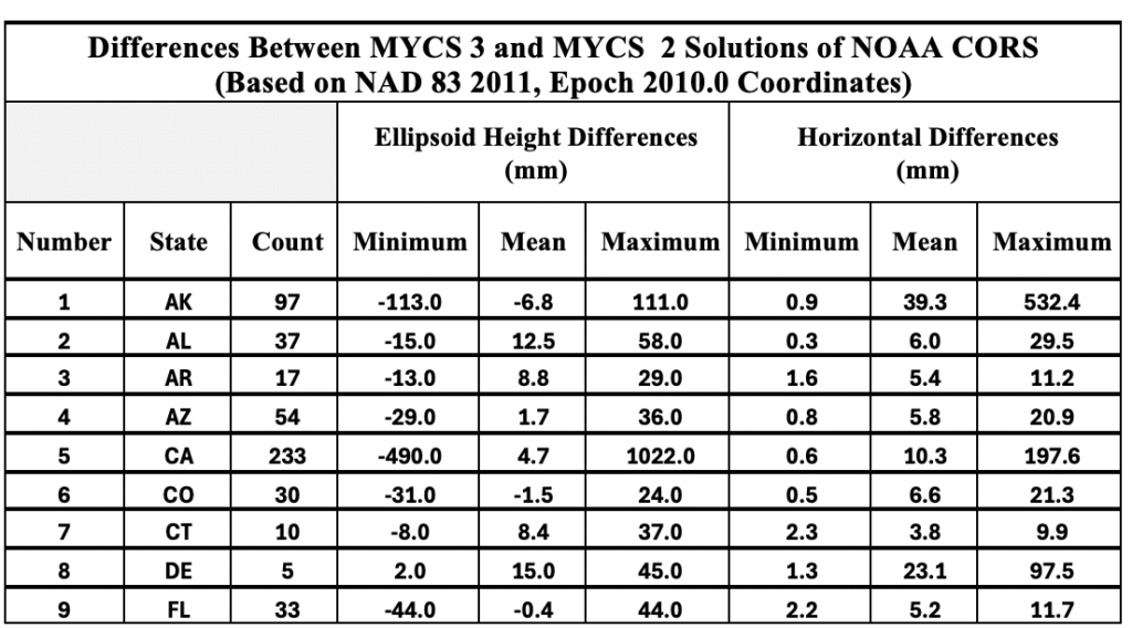
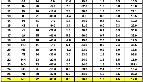
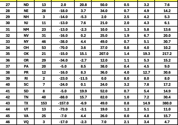
I suppose for all “practical purposes” the changes are small and shouldn’t impact most survey projects. Some of the larger changes are probably a good thing because that may mean that the CORS coordinates needed to be updated to account for movement or something else that affected the coordinates. I created a table that provides the minimum, mean, and maximum values in ellipsoid height and horizontal differences. See the table titled “Differences Between MYCS 3 and MYCS 2 Solutions of NOAA CORS.” I highlighted the State of North Carolina values.
So, why is it important to understand these differences? The NGS Online Positioning Users Service (OPUS) has begun processing data with NCN control that is consistent with ITRF2020 at the time of measurement. This means that if you compare old projects to new projects, you may find some small differences due to the change in CORS NAD 83 2011, epoch 2010.0 coordinates. As I previously mentioned, these differences are small and should not affect the results of most survey projects. Although, any difference can lead to someone questioning their results.
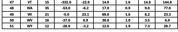
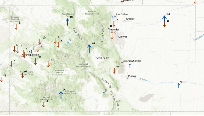
As another example of the changes, the two plots below in the image captioned, “Change in CORS coordinates in Colorado based on ITRF 2020” provides the differences between MYCS3 and MYCS2 NAD83 2011, epoch 2010.0 published coordinates for the CORS in Colorado.
Change in CORS coordinates in Colorado based on ITRF 2020 Ellipsoid Height Change (units in mm).Change in CORS Coordinates in Colorado based on ITRF 2020 Horizontal Change (units in mm).
Another difference that I computed using the results from the MYCS3 solution is an estimate of the changes between the current NSRS, that is NAD 83 2011 (epoch 2010.0) and new NSRS, for example NATRF2022, epoch 2020.0. This is only an estimate but provides a value that users can attain the magnitude of the changes in their local region. The image below depicts the approximate changes in horizontal and vertical components between the current NSRS (NAD 83 2011, epoch 2010.0) and the future NSRS (NATRF2022, epoch 2020.0) based on the CORS in the NCN. (Note that the units have changed to cm.)
Differences between ITRF2020 and NAD 83 2011 in NC Horizontal Change (units in cm).Differences between ITRF2020 and NAD 83 2011 in NC Ellipsoid Height Change (units in cm).
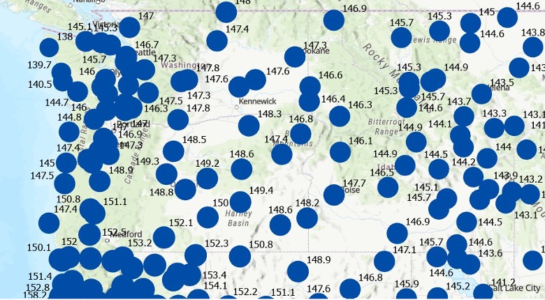
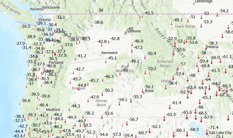
To demonstrate that these changes vary region by region, I prepared plots depicting the changes in the State of Washington and the U.S. Gulf Coast region. As indicated in the plots, the differences between the current NSRS and the new modernized NSRS will vary from state to state and are significantly different than the current NSRS coordinates.
Differences between ITRF2020 and NAD 83 2011 in Washington State Horizontal Change (units in cm).Differences between ITRF2020 and NAD 83 2011 in Washington State Ellipsoid Height Change (units in cm). Differences Between ITRF2020 and NAD 83 2011 in the Gulf Coast Region Horizontal Change (units in cm). Differences Between ITRF2020 and NAD 83 2011 in the Gulf Coast Region Ellipsoid Height Change (units in cm).
This newsletter underscored upcoming OPUS product changes that NGS will implement following adoption of the modernized NSRS, along with updates to CORS station coordinates resulting from the Multi‑Year CORS Solution 3 (MYCS3). It clarified what these changes mean for users of the U.S. NSRS. I also flagged several topics in the NGS News bulletins that warrant further attention, as they are critical for understanding how the modernized NSRS will impact geospatial products and services. The new NSRS offers a strategic opportunity for users to comprehensively review existing processes and workflows, reassess current products, and proactively plan for future requirements. By auditing geospatial data dependencies now, NSRS users can evaluate how transitioning to the new datum will impact workflows, datasets, and operational decision-making.
Will you be ready to implement the new NSRS after NGS officially adopts it? Will you have the appropriate tools available to implement the new NSRS? These are questions that everyone that uses the NSRS should be addressing now.
Exail has signed a contract to supply 100 Phins compact inertial navigation systems (INS) to a U.S.-based global defense company for use in unmanned underwater vehicles (UUVs). The Phins Compact INS is designed to provide precise navigation capabilities in challenging environments, remaining functional even when external signals are disrupted. The system’s compact design enables rapid integration into UUVs, allowing for flexible and efficient mission operations in dynamic maritime settings.
According to the company, this contract strengthens Exail’s global leadership in subsea navigation, with its INS technology trusted by more than 50 navies and widely deployed on a broad range of subsea autonomous vehicles worldwide. It also represents a key milestone in the company’s expanding presence in the United States, supporting defense programs with proven, high-performance solutions.
New collaboration to demonstrate how terrestrial 5G-based timing can provide scalable solutions to complement and backup GPS.
NextNav and Oscilloquartz, a division of Adtran, have partnered to demonstrate how 5G-powered terrestrial positioning, navigation, and timing (PNT) technology combined with Oscilloquartz’s established synchronization systems can serve as a scalable complement and backup to GPS. The initiative aims to maintain the operation of critical infrastructure, such as data centers, utilities, and emergency services, during GPS outages by distributing precise, coordinated universal time (UTC) over existing 5G networks for both indoor and outdoor environments.
The collaboration integrates Oscilloquartz’s synchronization technology with NextNav’s terrestrial 5G PNT platforms to introduce an additional timing source, thereby reducing end-user dependence on GPS alone. This effort addresses increasing demand for secure and redundant timing solutions in light of threats to GPS reliability. The companies are aligning their technologies with ongoing Federal Communications Commission initiatives to encourage complementary PNT solutions.
According to the companies, this approach responds to national security and public safety concerns by prioritizing the development of resilient infrastructure. The demonstration of these integrated terrestrial timing capabilities is intended to provide a practical example of how industry can build more robust timing networks and reduce the risks associated with relying solely on GPS.
Launched in 2003, Canada’s Precise Point Positioning (PPP) service, CSRS-PPP, continues to solidify its place as a world-class GNSS post-processing platform. Operated by the Canadian Geodetic Survey (CGS) under Natural Resources Canada (NRCan), the service enables users to obtain highly accurate coordinates from raw GNSS data without requiring proximity to a base station. Users simply upload RINEX observation files from either static or kinematic receivers, and CSRS-PPP returns positions referenced to NAD83(CSRS) or the International Terrestrial Reference Frame (ITRF). Crucially, this free and publicly accessible service is contributing enormously to the democratization of centimeter-level GNSS positioning for users around the world.
Galileo PPP-AR Now Supported
On May 14, 2025, CGS released a major upgrade to the service that introduced support for GalileoPPP with Ambiguity Resolution (PPP-AR). This new capability applies to Galileo E1/E5a signals recorded on or after November 27, 2022, and is available when using either Rapid or Final products. These “products” refer to high-precision satellite data; specifically, calculated information about satellite orbits, clock corrections, and signal biases, based on data collected by a global network of stations. The collected data are processed by NRCan and international partners to support CSRS- PPP’s precise positioning outputs. The recent CSRS-PPP upgrade builds on the PPP-AR support for GPS added in 2020 for data recorded on or after January 1, 2018, marking a significant step toward fully integrated, ambiguity-resolved positioning using data from multiple GNSS constellations.
Why PPP-AR Matters
The major milestone in October 2020, when ambiguity resolution was introduced to the CSRS-PPP platform, ushered in a new era of precision for users. At the core of PPP-AR is a significant shift in how satellite signals are interpreted. Traditional PPP estimates carrier-phase ambiguities as ‘float’ (real-valued) parameters because the integer number of whole carrier wavelengths between satellite and receiver remains unknown and unresolved. In contrast, PPP-AR resolves these ambiguities as fixed integers by utilizing precise satellite orbit and clock products alongside detailed modeling of satellite and receiver biases, thereby enabling reliable integer ambiguity resolution. This leap in algorithmic refinement leads to faster convergence times and enhanced accuracy, often down to the centimeter level. Ambiguity Resolution can lead to particularly noticeable improvements on east–west accuracy, which makes PPP-AR particularly valuable in applications demanding high horizontal precision.
CSRS-PPP Advances: Broader Satellite Support and Richer Output Data
Since its inception, CSRS-PPP has evolved steadily. Alongside expanded satellite constellation support, the platform’s reference frame has progressively advanced through updates from ITRF2005 to subsequent realizations, culminating in the adoption of ITRF2020. Additionally, CSRS-PPP output files now include valuable metrics such as estimated tropospheric delays, receiver clock offsets, and ambiguity resolution statistics. These enhancements provide users with more detailed insights into solution quality.
Meeting Growing Demand
Canada’s geodetic services continue to experience strong growth, with an increasing number of users relying on the CSRS-PPP service and related geodetic tools for essential positioning information. According to the Surveyor General Branch Annual Report for 2022–2023, file retrievals through CSRS-PPP and related tools increased by 45% in 2022 compared with 2021. Between 2022 and 2023, CGS supported over 11,000 active users and processed close to 1.3 million files across its suite of geodetic products and services.
An Evolving Platform
Even as this article was being written, on July 15, 2025, CSRS-PPP announced support for GPS signals C1L, L1L, C1X and L1X, further enhancing its capabilities and reaffirming its role at the core of a modern geodetic infrastructure. As GNSS shifts toward multi-frequency, multi-constellation services, CSRS-PPP is evolving in parallel, making centimeter-level accuracy accessible to a wider user base. With robust algorithms and enriched data outputs, CSRS-PPP remains a critical tool for high-precision positioning in Canada and a model for international GNSS services.
Disclaimer: A previous version of this article contained an error that has since been removed. We strive for accuracy and transparency, and the current version reflects updates correcting this mistake. Please refer to the information below for more current and accurate details on India’s NavIC satellite constellation.
India’s regional satellite navigation system, NavIC (Navigation with Indian Constellation), is facing a severe operational crisis, with only four of its 11 satellites currently operational, according to government data and news reports.
Developed and maintained by the Indian Space Research Organisation (ISRO), NavIC is intended to provide precise positioning, navigation and timing (PNT) services across India and up to 1,500 km beyond its borders. However, this constellation is now on the brink of becoming near-defunct, according to the Indian Defence Research Wing.
Of the four satellites still fully operational, IRNSS-1B has already exceeded its planned 10-year mission life and is at risk of imminent failure. At the same time, IRNSS-1F is also nearing the end of its lifespan with partial equipment failures. IRNSS-1I, launched in 2018, is expected to remain functional until around 2028 but its longevity remains uncertain given the premature failures in the constellation.
The failure of NVS-02 to reach orbit halted progress and highlighted technical challenges that ISRO must address to avoid repeat failures. The Indian government has committed to launching the remaining NVS satellites (NVS-03, NVS-04 and NVS-05) by the end of 2026.
Timely replacement and system upgrades are crucial for maintaining India’s strategic autonomy and meeting the growing demands for accurate, independent navigation services in both civilian and defense applications.
HawkEye 360 has made powerful enhancements to its GNSS Interference (GNSS-I) Detection product suite. The upgrades — designed with defense, intelligence and national security operations in mind — offer unprecedented accuracy, coverage and insight into global GPS jamming and spoofing threats.
The update includes a new wider frequency algorithm that better distinguishes individual emitters, incorporates GPS spoofing detection, and is terrain adjusted for better geolocation accuracy, delivering greater situational awareness and more precise geolocation of interference sources worldwide.
HawkEye 360’s enhanced GNSS Interference Detection product suite supports strategic decision-making by providing timely, precise insight into potential signal disruptions, enabling stakeholders to better assess risk, respond confidently, and maintain operational continuity in dynamic environments.
With this release, HawkEye 360’s GNSS-I Detection product suite now provides:
15 times increase in geolocation density
Spoofing detection and differentiation
Terrain adjusted for increased accuracy
Consistent monitoring across wide areas of interest
HawkEye 360’s new spoofing detection capability identifies potentially malicious transmitters that imitate legitimate GPS course/acquisition (PRN) codes — a tactic increasingly used to deceive aircraft and mislead navigation systems. The capability supports threat mitigation and trend analysis by detecting and geolocating these spoofers down to a kilometer-level precision.
“In contested environments, timely RF intelligence is the key to mission success,” said Alex Fox, president, International Business Unit. “Traditional land, sea, and air systems struggle in Anti-Access/Area Denial environments, while our satellites provide global GNSS-I detection and geolocation coverage. These enhanced capabilities give defense and intelligence teams the ability to identify and neutralize threats before they disrupt operations, enabling faster decisions and sharper visibility into adversary behavior.”
The construction of the Perca Bypass, a critical infrastructure project underway in the Italian Alps, highlights the increasing role of advanced technology in managing complex builds. Located near the village and commune of Perca — a destination known for its tourism trade — the new 632 m tunnel and supporting road network are designed to improve regional connectivity and enhance commuter safety.
The project, which began in 2023 and is expected to take three years to complete, is being delivered through a joint venture between European construction group Strabag and regional specialist Alpenbau. Once finished, the bypass is expected to relieve the flow of up to 26,000 vehicles that pass through Perca daily during peak periods, easing congestion and opening new routes for both tourism and local commerce.
Given the large number of machines, teams, and partners involved, coordinating the work requires effective management and communication tools. Alpenbau, drawing on a long-standing collaboration with Topcon Positioning Systems, the team is now using Topcon’s Aptix Integration Platform, which enables site managers to monitor and oversee progress remotely, offering real-time insights into workflow and project status without leaving their offices.
Acting with Aptix
“Aptix is a very convenient solution for us to manage our construction sites,” said Benjamin Niederkofler, CEO of Alpenbau. “One of the advantages of Aptix is that you can directly load 3D models onto machines that are equipped with machine control systems. This means that you always have the possibility to monitor the site from the office. This is a very important and fundamental tool for us to remotely monitor a construction site.”
Aptix consolidates data from different contractors and machinery, regardless of the manufacturer or operating system, and provides a comprehensive view of project performance. Senior leaders can access essential metrics in real time, such as work progress, fuel consumption, and carbon emissions, improving the ability to make informed decisions.
Control, Collaboration, Clarity
Throughout every stage — from planning and design to actual construction — the platform supports automatic workflows that deliver designs to machines and collect telematics data without manual intervention. This automation reduces the risk of missing information and helps maintain clear communication among stakeholders.
A joint effort of this scale requires constant collaboration among contractors, local authorities and other stakeholders. The Aptix platform helps facilitate transparency in workflows by allowing access to daily productivity reports and construction data, supporting open cooperation and oversight for both project managers and crew.
“Recently it has become increasingly important that we create transparency and co-operation on this construction site and share productivity daily with construction management or even with our customers,” said Niederkofler. “Having this transparency across the entire construction site is a decisive advantage.”
Andrea Marzi, technical director at Strabag Italy, added, “This unique platform allows all parties involved in the project to access all relevant construction information and data.”
Once completed, the Perca Bypass is expected to generate new economic opportunities for the region. Project leaders say that by adopting innovative digital workflows and centralized data management, they are able to direct complex operations more effectively and deliver the project with increased speed and accuracy.