Spire Global Inc., a global provider of space-based data, analytics and space services, was awarded a $11,190,900 contract from the National Oceanic and Atmospheric Administration (NOAA) to provide GNSS radio occultation (RO) data for a one-year period from Sept. 18, 2025, to Sept. 18, 2026.
The company’s near-real-time GNSS-RO data consists of vertical profiles of atmospheric measurements, including pressure, humidity and temperature, that can reach all points of the globe. NOAA, together with NASA, the U.S. Air Force and the U.S. Navy, will integrate Spire’s GNSS-RO data into their weather and space weather models, while additional U.S. and international agencies will leverage the data to strengthen forecasts and advance climate research.
“Spire’s satellites and radio occultation data are uniquely positioned to deliver the atmospheric insights needed to tackle today’s complex weather challenges,” said Theresa Condor, CEO at Spire Global. “Our continued work with NOAA underscores the importance of government–commercial partnerships in advancing weather forecasting and highlights NOAA’s commitment to harnessing innovation to improve forecasts and build climate resilience.”
The award is part of an Indefinite Delivery Indefinite Quantity (IDIQ) contract for NOAA’s Commercial Weather Data Program Radio Occultation Data Buy II.
The GEO-3 satellite Eutelsat 5 West B (PRN 121) is now part of the European Geostationary Navigation Overlay Service (EGNOS) operational platform and broadcasts the Operational Signal-in-Space.
PRN 121 began broadcasting operational signals Aug. 25 as part of EGNOS System Release 2.4.3. The upgrade seeks to strengthen service continuity and prepare the system for future enhancements.
The transition involved swapping satellite roles within the EGNOS constellation. On Sept. 5, the GEO-2 satellite ASTRA 5-B shifted from operational to test status, creating a new configuration with GEO-1 and GEO-3 handling operational duties while GEO-2 serves as the test platform.
The changes will not disrupt service or affect coverage areas, officials said.
“Eutelsat is proud of its long-standing collaboration with EUSPA,” said Arlen Kassighian, chief engineering officer of Eutelsat. “We are delighted to host this payload, which will continue to significantly enhance the performance of global navigation satellite systems across Europe in the coming years.”
The system release represents preparation for EGNOS V3, the next-generation platform that will offer enhanced performance, improved robustness and dual-frequency multi-constellation capabilities for European satellite navigation services, according to Jean-Marc Pieplu, head of EGNOS Exploitation Department.
The European Union Agency for the Space Programme manages the EGNOS space segment, system upgrades and service provision. The agency’s integration of the GEO-3 satellite ensures EGNOS continues providing reliable augmentation services for safety-critical and professional applications throughout Europe.
Advanced Navigation is moving forward with plans to establish international positioning, navigation and timing (PNT) Centers of Excellence, with the UK location selection process currently underway.
The company is evaluating potential sites based on access to technical talent, logistics capabilities and proximity to major international airports. The final UK center location will be announced in late 2025, with additional global centers confirmed in early 2026.
Over the past year, Advanced Navigation has doubled its workforce and significantly expanded manufacturing capacity to address surging defense sector demand. The international COE network represents the next phase of the company’s growth strategy, positioning it to double its team again within 12 months.
“In an era of increasing complexity and contested environments, the ability to navigate with absolute certainty is becoming the world’s most critical strategic asset,” the company stated.
Building Supply Chain Resilience
To complement its Australian operations and establish robust onshore supply chains meeting local standards and security requirements, Advanced Navigation plans to partner with regional specialists in critical PNT sensing technologies, including:
Inertial sensing (optical gyroscopes and MEMS)
Vision-based sensing
Lidar and radar sensing
Acoustic Doppler velocity log sensing
The company emphasizes that navigation’s future depends on integrating diverse, adaptable sensor suites rather than relying on single technologies. Through its multi-sensor approach centered on inertial systems, the company aims to deliver resilience even in severe GPS-contested environments.
The expansion will accelerate innovation cycles, strengthen quality assurance and create opportunities for partners and research institutions across America and Europe to collaborate on breakthrough technologies.
Strengthening NATO Capabilities
The strategic expansion directly addresses NATO forces’ evolving operational needs. By establishing presence within U.S. and European industrial landscapes, Advanced Navigation aims to bolster critical infrastructure resilience while creating collaboration opportunities and jobs.
Beyond scaling production, the centers will focus on enabling seamless interoperability across NATO’s land, sea and air platforms, reducing integration time and costs for member nations. The COE network positions the company to power the next generation of autonomous systems and alternative PNT solutions worldwide.
Advanced Navigation said the Boreas D90 FOG INS represents the type of technology that will be developed and manufactured at these new facilities.
TomTom has launched its Automotive Navigation Application, a navigation solution designed for automakers that combines TomTom Orbis Maps with an enhanced user interface layer built on the company’s Navigation SDK. The company said the integrated solution allows car manufacturers to deploy navigation systems more quickly while reducing development costs and timelines.
The application addresses growing demand in the automotive industry for software-defined vehicles (SDVs), where rapid integration capabilities have become essential for meeting market expectations. TomTom designed the system to help automakers focus on delivering innovative solutions rather than spending extensive resources on navigation development.
The company conducted comprehensive testing of the application on automotive-grade hardware, including end-to-end evaluations performed directly in vehicles. This testing process ensures automakers receive a production-ready application that meets industry quality standards.
The solution provides automakers with three key components: an off-the-shelf navigation application, a user experience library for customizing driver interfaces, and a vehicle integration library with documentation that enables independent connection between vehicles and the application. This structure seeks to streamline the integration process for manufacturers and their partners.
Built on TomTom Orbis Maps, the application uses updated map data designed to provide accurate and reliable navigation information. The system includes dynamic caching functionality that delivers continuous updates, ensuring drivers receive current route information. Automakers can customize the navigation experience to align with their brand identities through the Mapmaker tool, which simplifies the customization process without requiring extensive development time or costs.
The application incorporates 3D visualization and electric vehicle-optimized navigation features. For electric vehicles, the system integrates with the vehicle’s battery status to provide charging stop recommendations. The charging finder feature helps drivers locate charging stations based on their subscriptions and preferences, while advanced filters allow trip planning that includes access to desired amenities along routes.
TomTom continues to offer its standalone Navigation SDK alongside the new application. The SDK has customizable features for in-house developers who prefer to build their own navigation systems, giving manufacturers options based on their specific requirements and development capabilities.
Aerospace and defense applications depend on position, navigation and timing (PNT) technology for mission-critical accuracy and reliability. But integrating PNT into designs requires extensive specialized knowledge.
To accelerate development, Microchip Technology has introduced a portfolio of GNSS Disciplined Oscillator (GNSSDO) modules that integrate the company’s atomic clock and oscillator technologies, including the Chip-Scale Atomic Clock, Miniature Atomic Clock and Oven-Controlled Quartz Crystal Oscillators.
The GNSSDO modules process reference signals from GNSS or alternative clock sources and discipline onboard oscillators to reference signals, enabling precise timing, stability and holdover performance based on application requirements. The modules serve military and defense applications including radar, satellite communications, mounted and dismounted radios, vehicle platforms and other critical PNT applications, including GNSS-denied environments.
A GNSSDO module functions as a PNT subsystem within larger system designs or as a standalone system, providing precise timing critical to high-performance systems. Microchip engineers and manufactures the local oscillators used in the modules. Other Microchip components include 32-bit microcontrollers and SmartFusion 2 field-programmable gate arrays.
MD-013 ULTRA CLEAN: Microchip’s highest-performance standard GNSSDO module supports multiple GNSS constellations or external reference input. The module uses a high-performance OCXO that enables outputs with ultra-low phase noise and short-term frequency stability. Phase noise performance specifications are minus 119 dBc/Hz at 1 Hz offset and noise floor of minus 165 dBc/Hz. Short-term frequency stability, measured by Allan Deviation, is 3E-13 at 1-second tau, 6E-13 at 10-second tau and 9E-13 at 100-second tau. The module generates 1 PPS TTL, 10 MHz sine wave and 10 MHz square wave outputs disciplined to an embedded 72-channel single-band GNSS receiver, with optional upgrade to configurable L1/L2 or L1/L5 dual-band, multi-GNSS receiver.
MD-300: Designed for harsh environments in a 1.5 in-by-2.5-in footprint, the MD-300 features an embedded MEMS OCXO or TCXO as the local oscillator, enabling low g-sensitivity, high shock and vibration tolerance and low thermal transient response. Its size, weight, and power performance make it suitable for applicationssuch as drones and manpacks. The module disciplines to embedded GNSS receivers or external references and outputs high-performance 10 MHz and 1 PPS signals.
LM-010: A PPS disciplined module providing precise timing for Low Earth Orbit applications requiring radiation tolerance with stability and holdover capability. The standard platform module provides 1 PPS TTL and 10 MHz sine wave outputs disciplined to an external reference input. The module contains Microchip’s digitally corrected OCXO or low-power CSAC SA.45.
The GNSSDO modules use common serial communication protocols and graphical user interfaces for command and control. Software can configure various parameters, including inputs, outputs, auto switching, holdover parameters, GNSS tracking and observables, and reporting messages from the serial interface.
The intriguing paradox about the information age is that it relies on semiconductor chips, which are fundamentally made from sand (silicon dioxide) — the most tangible and seemingly infinite resource on Earth. Yet, in 2023, the global digital storage capacity reached 110 zettabytes (110 followed by 21 zeros), which is a staggering figure; in fact, it is 15,000 times more than the number of grains of sand on Earth and it’s doubling every three years. The information age is suffering from excess information. Data is consuming the universe.
The velocity and quantity of information are overloading the ability to process it. This causes data-driven decision-making systems to fail. The limiting factor is human cognitive capacity to select, prepare and process the data, plus the ability to analyze it for meaningful insights. It is reminiscent of the early days of the Corona satellites of the TALENT KEYHOLE (KH) mission series that began in the 1950s during the height of the Cold War.
Understanding activities behind the Iron Curtain was critical for national security. The KH satellites were expensive to launch and had short life spans. They used rolls of wet film dropped from space and captured by specialized aircraft with hooks to catch the canisters in mid-air. The low-resolution images (3 m to 5 m per pixel) were processed manually in darkrooms. Teams of 100 specialists, using razor knives and scotch tape, meticulously pieced together image strips into massive mosaics spanning several square meters. Working around the clock, assembling the full image would take up to five days, with subsequent analysis requiring another week. In total, from catching the film canister to delivering a final intelligence report, it took 17 days — a testament to imagery intelligence in the industrial era, characterized by massive operations demanding significant time and manpower, but it was too expensive and unsustainable.
Photo: PRESIDENT EISENHOWER awards Capt. Mitchell, USAF, C-119 pilot, the Distinguished Flying Cross for the first ever capture of
a film cartridge dropped from space, in a photo circa 1960. cia.gov/resources/csi/static/corona.pdf
“We live in a world where there is more and more
information, and less and less meaning.”
— Jean Baudrillard,
“Simulacra and Simulation,” 1994
In 1976, the technological landscape shifted dramatically with the launch of the KH-11 satellite, which could transmit 15 cm resolution images digitally to ground stations and was capable of distinguishing objects as small as a dinner plate. The satellite dramatically compressed intelligence-gathering timelines. Processing and analysis time decreased from 17 days to mere hours. The first digital image was shown to President Carter. That first image is believed to be of ongoing tensions in the Middle East, but it symbolized more than the triumph of technology; it represented a fundamental shift marking the end of the industrial era and ushered in the information age.
Advancements in imagery were paralleled by developments in mapping, driven by the need for accurate spatial referencing. Various technologies throughout the 1970s offered partial solutions, but a solution did not happen until 1981 when Esri introduced Arc/INFO, a breakthrough geographic information systems (GIS) software that could operate on minicomputers instead of huge mainframes. That formed the basis of modern spatial analysis and visualization technologies; coming together with digital imagery is what allowed the information age to overtake the industrial era.
In 2025, a similar technological transformation currently is underway. As the amount of information overwhelms existing systems, artificial intelligence (AI) is emerging as the solution. The information age is transforming into the intelligence age, where big processing meets big data. Advanced algorithms, machine learning and large language models (LLM) can swiftly and efficiently handle vast amounts of information. So, with data being the new oil, AI is the refinery.
TheEsri Federal GIS Conferencein February could have been promoted as the “Dawn of GeoAI” conference. The term Geo AI is a subset of Spatial AI, and it is in its infancy. Esri is incorporating AI into many of its applications. Companies at the expo were teasing Spatial AI solutions in their products and services.
What is Spatial AI?
When the transformative power of AI is combined with spatial information systems, magic happens. Value is created that did not exist before.
Spatial intelligence is the ability to think, visualize and understand in three dimensions. It is one of the primary types of intelligence. Currently, Spatial AI is capable of interacting with analysts using natural language to build models and perform tasks. Similar to so much else happening with AI, its capabilities are increasing rapidly.
Photo: A CORONA SATELLITE image of Moscow captured May 28, 1970, as part of the TALE…
With iterative learning, the AI repeats a task millions of times on various training data to perfect its abilities, running through different scenarios multiple times with different datasets while completing multiple tasks. The AI quickly learns and can eventually surpass humans. This makes AI a super tool.
Combine that capability with AI’s ability to access and infer an entire compendium of knowledge on a subject. The AI is able to ingest text, images, audio and video in minutes, and then reason and understand them all within the context of the parameters provided. Through its own AI agents, it will automatically run functions to garner insights, and then communicate those results through data visualizations, text, audio and natural speech. Spatial AI is an evolved form of AI able to understand data in the context of space and time within the body of knowledge it can access. It will monitor everything in real time to identify anomalies and hidden patterns and provide deep insights. It doesn’t just solve the information overload dilemma for data-driven decision-making, but it enhances it far beyond expectations.
The Coming World of AI Assistants
The future is already here. Reality is approaching science fiction at warp speed. A person living 100 years ago would only be able to understand the world of today as magic; and likewise, the world 20 years from now will appear magic to us.
Interfacing with a Spatial AI system is similar to the multi-dimensional world we already exist within. Flat screens, keyboard and mouse will be secondary tools behind natural language and natural gestures and immersive experiential environments. The Spatial AI- enabled world will blur the lines between what is virtual and what is real. Jobs, businesses and the economy already are transitioning. The most well capitalized businesses are investing in this new technology.
One of the industries at the forefront is healthcare. Imagine you are a neurosurgeon. Your patient has a glioblastoma identified by the MRI/CT scans uploaded into the Spatial AI Medical Assistant called SAIMA (pronounced Sāmă; when speaking with the system, you call it “Sammi”). The MRI/CT scans show a 3D model of the patient’s brain, highlighting the glioblastoma in red. Placing the integrated augmented reality (AR) glasses on, you can zoom in on the glioblastoma to see the extent of the growth and view it from any angle. This helps formulate a surgery plan. The patient’s medical records are in SAIMA along with the corpus of knowledge about glioblastomas. SAIMA is regularly updated with the latest algorithms and models. After reviewing the preliminary data, you have SAIMA run the spatial analytics and all the applied functions on the data. It takes approximately 35 minutes to complete. During that time, you review the SAIMA updates and go to lunch. You receive a text message from SAIMA after it completes its processing, letting you know it is finished without encountering any issues. SAIMA works with a system called VisAR, which is a precision surgical navigation system. After returning to your office, you put on the VisAR glasses to begin the review. Sammi begins by showing you the glioblastoma and pointing out it is a large, heterogeneous mass located in the frontal lobe and appears to be 4 cm to 5 cm in diameter, in an irregular shape with nodular and cystic components. As it goes through the review, it zooms in and rotates the 3D image, highlighting the exact area being talked about. You interrupt Sammi during this review and ask if the patient has been experiencing motor function issues since the tumor is in the frontal lobe, and you continue to probe further in a natural conversational tone as you delve deeper into the analysis. The conversation between you and Sammi is recorded and added to the file.
The review with Sammi takes several hours, during which a high-confidence surgery plan is developed that you will present to the multidisciplinary tumor board, who will further query SAIMA. This thorough process ensures the best results and further trains SAIMA about glioblastomas, which will be used for a post-surgery debrief and for insurance purposes. Following a successful board meeting, SAIMA proceeds to reserve the operating room, schedule the patient, and create a detailed surgery plan with specific duties and exact times for each member of the surgical team. This plan is then disseminated to all members of the surgical team and preoperative staff. A detailed surgical procedure file is generated, which serves as a navigation file, similar to Waze or Google Maps, providing step-by-step instructions to guide the surgery. This file will be loaded into ROSA (Robotized Surgical Assistant), a high-precision robotic surgeon.
On the day of the surgery, you wear special Bluetooth gloves that are synced with the SAIMA/VisAR glasses and ROSA. In real-time, magnified between 15x and 40x, you observe ROSA surgically removing the cancerous tissue. Overseeing the process, you see a tumor that has spread beyond the original CT/MRI scan and zoom-in on the tumor, and you take control of ROSA to manually remove the tissue. The surgical system uses a “differential engine” concept to scale down the surgeon’s movements to match the magnification level of the procedure, allowing for precise and delicate tissue removal. This means that the surgeon’s natural movements are reduced to a smaller, more precise scale, enabling accurate and intricate procedures. For example, a 1 cm movement by the surgeon might be translated into a 0.1 mm movement of the robotic arm, allowing for high-precision work. The system is dependent upon a high-level of spatial intelligence to make those calculations in real-time.
Afterward, you return the surgery back to the automated control of ROSA to follow the surgical procedure file plan. Throughout the fully immersive procedure, you speak with Sammi in a calm, natural language and responsive manner.
The patient, a married middle-aged father of two, not only survives but thrives because of the accurate analysis of SAIMA and the precision of ROSA, with you overseeing the entire process. The Spatial AI-based surgical system allows you to do what you wanted to do as a neurosurgeon and save people’s lives.
Nothing is Permanent Except Change
Breakthrough innovations, such as the internet, have changed the world. Spatial AI is going to do the same. These technologically driven schisms are huge opportunities. One can only speculate how it will alter the future. Once a technology takes hold, and it becomes obvious there is no going back, its adoption will accelerate, and in those moments, careers make exponential leaps. Those in front of it will make substantial gains. Position yourself accordingly. Learn about Spatial AI and Geo AI. Carve out your own specialty, such as Spatial AI/AR (augmented reality), Spatial AI/VR (virtual reality), Spatial AI/XR (mixed reality), and Spatial AI/FMV (full motion video). The future is yours to imagine.
Photo: William Tewelow
WILLIAM TEWELOW is a designated Geographic Information Systems Professional. He has a master’s degree in Organizational Leadership with a focus on Performance Management, a bachelor’s degree in Intelligence Studies focused on geospatial intelligence, and an undergraduate degree in Geographic Information Technologies. William retired from the Federal Aviation Administration in 2025 after 16 years in various roles supporting geospatial information for aviation operations in the national airspace. He is a graduate of the management fellowship Program for Emerging Leaders where he served on special assignment to the Department of Transportation, leading a national strategic geospatial initiative under the authority of the White House Open Data Partnership.
The European Space Agency (ESA) has confirmed plans to launch the first two satellites in its low-Earth orbit (LEO) positioning navigation and timing (PNT) constellation in the second half of December 2025. The launch will use a Rocket Lab Electron Vehicle, marking Europe’s first venture into LEO-based satellite navigation.
The LEO-PNT in-orbit demonstrator mission, called Celeste, aims to test satellite navigation capabilities in LEO and evaluate its integration with existing medium-Earth orbit (MEO) systems.
Celeste features a constellation of ten satellites that will fly close to Earth to test innovative signals across various frequency bands. The first two Celeste satellites, built in parallel by GMV and Thales Alenia Space, are set to launch in the coming months.
The dedicated Electron rocket launch will place both satellites in orbit at 510 km altitude. The launch window extends for three months beginning in mid-December 2025, with operations conducted from Rocket Lab’s New Zealand facility.
ESA Director of Navigation, Javier Benedicto, said, “We are thrilled to see the LEO-PNT demonstration advancing so quickly, with less than two years between mission kick-off and launch. This launch ensures the first European LEO-PNT satellites are in space before spring 2026, crucial for bringing the frequencies into use in compliance with the International Telecommunications Union.”
Galileo’s “Daughter Mission”
The name Celeste pays homage to Maria Celeste, Galileo Galilei’s daughter, as the two shared a strong emotional and intellectual bond, with the daughter honoring her father’s astronomical interest. This symbolic connection links the pioneering work of the father of modern astronomy to contemporary navigation systems, with Celeste serving as a bridge between Galileo’s groundbreaking discoveries and today’s satellite-based positioning technology.
The demonstrator satellites for Galileo, launched in 2005 and 2008, were called GIOVE, after the Italian word for Jupiter. This name also paid tribute to Galileo’s achievements in discovering the planet’s four largest Moons which were used to determine longitude from anywhere on Earth.
System Advantages
The initial Pathfinder A satellites are CubeSats measuring 12U and 16U formats, comparable to suitcase size and weighing approximately 20 kg to 30 kg. These satellites will broadcast in L-band and S-band frequencies and operate for at least six months following orbital commissioning.
The larger, more complex Pathfinder B satellites will follow, incorporating additional payloads to test innovative signals across multiple frequency bands and demonstrate expanded services.
LEO-PNT satellites will supplement existing GNSS constellations by providing enhanced coverage in challenging environments. The system aims to improve navigation services in deep urban areas, under heavy foliage, in polar regions and potentially indoor locations where current MEO satellites face limitations.
The complete demonstrator constellation, expected to be operational by 2027, will assess how LEO navigation systems can integrate with existing GNSS infrastructure. The mission will also test interoperability with 5G and 6G communication standards.
Preparing for Launch
Satellite integration and testing of Pathfinder A hardware and software continues ahead of the December launch. ESA and industrial teams plan to complete testing during summer 2025, with qualification and acceptance reviews scheduled for autumn.
“Pathfinder A satellites have already paid off, even before launch,” said Roberto Prieto-Cerdeira, ESA’S LEO-PNT project manager. “The experience gathered during their development is helping to identify critical technologies, system design trade-offs, design choices and optimised approaches and processes, paving the way for future phases of LEO-PNT. Having them in orbit and validating their signals and algorithms is a major additional achievement.”
Future Plans
Following the demonstrator mission, ESA plans to propose an in-orbit preparatory phase at the agency’s November Ministerial Council meeting. This phase would focus on technology development and industrialization, potentially leading to an operational system integrated with EU GNSS infrastructure.
The Celeste demonstrator is part of FutureNAV, an ESA Navigation program designed to maintain Europe’s position at the forefront of satellite navigation technology.
The mission receives backing from 15 ESA member states: Austria, Belgium, Finland, France, Germany, Hungary, Italy, Norway, Poland, Portugal, Romania, Spain, Sweden, Switzerland and the United Kingdom. More than 50 entities from 14 countries participate in the two development consortia awarded contracts in 2024.
SPH Engineering has released a multibeam echosounder system for UAVs that uses the Cerulean Surveyor 240-16, a compact bathymetric sensor designed for shallow-water mapping.
The system expands drone-based hydrographic surveying capabilities by providing high-resolution bathymetric data collection over shallow waters. The Surveyor 240-16 operates at 240 kHz with a measurement range of 0.5 m to 50 m, targeting inland waterways, reservoirs, ports and environmental monitoring locations.
The multibeam system generates an 80° cross-track swath with a 16-element receive array and 1° angular resolution, allowing operators to map wider bottom coverage compared to traditional single-beam payloads.
The payload integrates with SPH Engineering’s UgCS flight planning software and SkyHub onboard computer for automated missions. Weighing 2.4 kilograms with all components and consuming 15 watts of power, the system works with UAVs including DJI M300, M350 and M400 models, as well as Inspired Flight IF800 and IF1200 aircraft.
SPH Engineering conducted field validation at Titutga Lake in Latvia in August 2025. Survey flights operated at an average speed of 1.2 m per second, balancing data collection density with UAV battery endurance.
Testing compared the multibeam system’s performance against single-beam payloads, which engineers noted remain useful for quality control verification of multibeam datasets. The combined approach demonstrated capabilities for high-resolution mapping in areas previously difficult to access with boat-based systems.
Software compatibility includes full support in BeamworX, with Hydromagic integration planned for future releases.
“The payload based on Cerulean Surveyor 240-16 represents a milestone in drone-based bathymetry,” said Alexey Dobrovolskiy, CEO of SPH Engineering. “By combining multibeam technology with UAV platforms, we are enabling hydrographers to collect dense bathymetric datasets at a fraction of the time and cost of conventional systems. This integration opens new opportunities for surveying reservoirs, lakes, and coastal areas that were previously inaccessible or unsafe.”
Advanced Navigation has released the Boreas 50 series, marking the company’s smallest fiber-optic gyroscope (FOG) inertial navigation system (INS).
The new product line consists of two devices, the A50 attitude and heading reference system and the D50 strategic-grade INS. Both units feature north-seeking gyrocompasses designed to determine true north without relying on GPS signals or magnetic references.
The 50 series weighs 910 g and incorporates Advanced Navigation’s sensor fusion technology, which processes data from multiple sensors to maintain accuracy during GPS outages or interference. The system can detect Earth’s rotation to establish directional orientation within minutes of activation.
An optional Electronic Counter-Countermeasure capability is available for the D50, designed to detect and counter GPS jamming and spoofing attempts. The feature targets operations in contested electromagnetic environments where adversaries may attempt to disrupt satellite-based navigation.
“The modern battlefield is no longer defined by only physical boundaries, but by electromagnetic dominance,” said Maximilian Doemling, head of product at Advanced Navigation. “Assuming navigation will ‘just work’ is a mission-critical oversight.”
Performance Specifications
The system achieves heading accuracy of 0.5° secant latitude through gyrocompassing, with roll and pitch accuracy of 0.03°. Positional accuracy reaches 0.01 m circular error probable at 50% confidence level when GPS is available.
The devices meet military standards for shock and vibration testing, addressing requirements for platforms operating in harsh environments. The compact form factor enables integration into space and weight-constrained systems.
Defense applications for the 50 series span multiple domains. Military pointing platforms, including radar systems, can use the technology for target tracking and identification while mobile or stationary. The system’s rapid stabilization capabilities support accurate targeting despite motion and environmental interference.
The Boreas 50 series is Advanced Navigation’s most compact FOG INS. (Credit: Advanced Navigation)
Counter-unmanned aircraft system platforms benefit from the precise heading and stabilization features when tracking aerial threats. The north-seeking gyrocompass enables rapid target acquisition and tracking in dynamic operational environments.
Maritime vessels operating under GPS-denied conditions can maintain navigation capabilities and threat identification through the system’s independent positioning features. The technology aims to preserve tactical advantages when satellite signals are unavailable.
Intelligence, surveillance and reconnaissance platforms, along with unmanned aircraft systems, can address navigation failures and targeting errors caused by electronic warfare and sensor drift. The compact design accommodates both new and legacy aircraft integration requirements.
Ground vehicles, whether autonomous or crewed, gain protection against electronic interference that could compromise navigation and situational awareness. The anti-jamming and anti-spoofing capabilities maintain consistent positioning data during operations.
Advanced Navigation‘s defense division consists of military veterans who collaborate with system integrators, program offices and end-users to develop tailored solutions. The company plans to double its defense team size within the year.
The firm’s vertically integrated manufacturing approach aims to reduce production lead times compared to industry standards. Products carry a three-year warranty, and the 50 series provides a direct upgrade path for users of the company’s existing Spatial FOG Dual system.
The technology represents ongoing development in assured positioning, navigation and timing systems as military operations increasingly face electronic warfare threats targeting GPS-dependent systems.
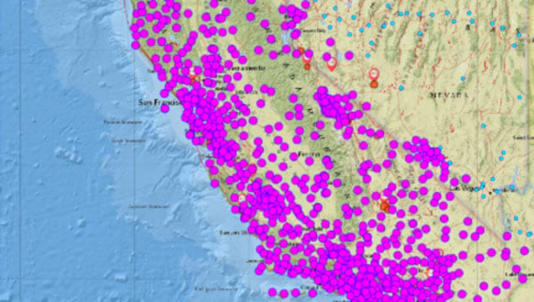
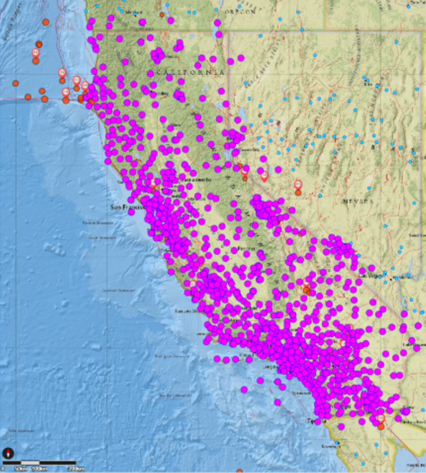
The California Spatial Reference Center (CSRC) modernized the California Spatial Reference Network (CSRN) on July 31, 2025. The new California Spatial Reference Network is denoted as CSRN Epoch 2025.00.
These coordinates changes affect California geospatial users, but the transition process to the new epoch is something that others should understand to prepare for the new, modernized National Spatial Reference System (NSRS), which is expected to be adopted in 2026. As I mentioned in my August 2025 newsletter, NSRS users should proactively assess their geospatial data dependencies and evaluate how adoption of the new datum will affect workflows, datasets and operational decision‑making.
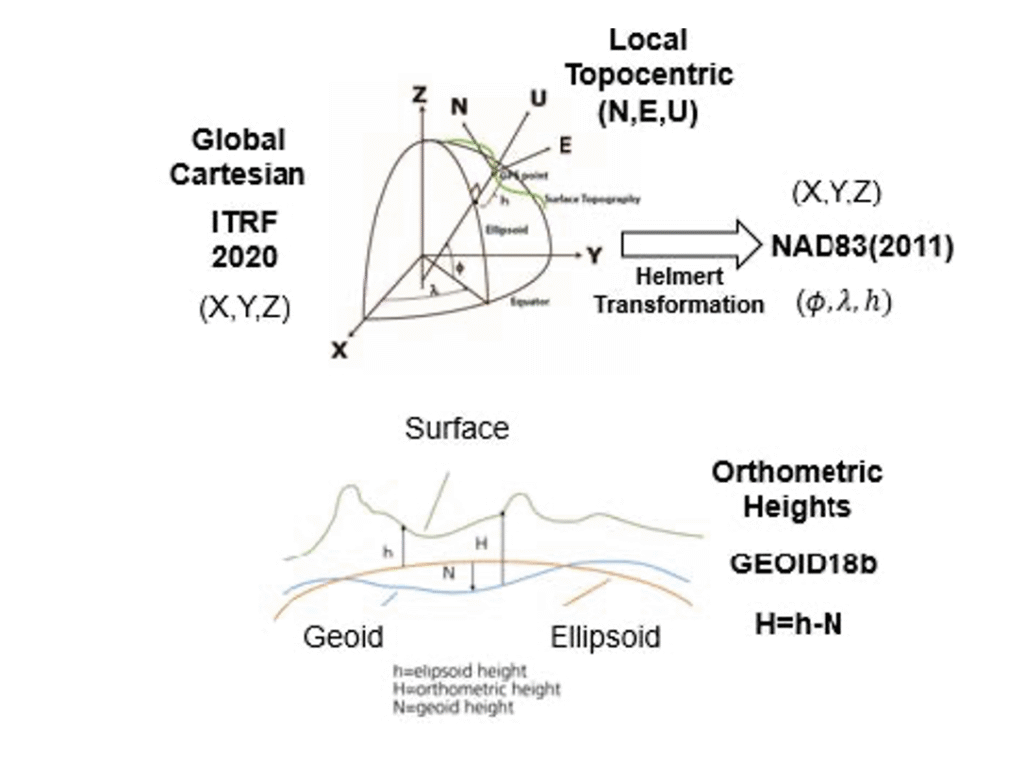
The California Spatial Reference System (CSRS) is the official geodetic datum in California, as published by the California Spatial Reference Center (CSRC) according to Public Resources Code (PRC) §§8850–8861. The image below depicts the CSRN. It is rigorously aligned to the current definition of the National Spatial Reference System (NSRS) through a set of coordinate transformations from ITRF2020 to NAD83(2011) as published by the NOAA/NOS National Geodetic Survey (NGS). The California Spatial Reference System (CSRS) is realized by the geodetic coordinates and uncertainties of the CSRN on the date of 2025.00 (January 1, 2025; GPS week 2347, day 3) of 1068 GNSS stations (881 active and 187 defunct stations) in California and at the borders of Arizona, Nevada, Oregon and Baja California. CSRN Epoch 2025.00 NAD83(2011) replaces the previous CSRS Epoch 2017.50 NAD83(2011).
The latest hybrid geoid model GEOID18 published by NGS was used to compute Global Navigation Satellite System (GNSS)-derived orthometric heights (DCOH) on the North American Vertical Datum of 1988 (NAVD 88) datum in accordance with the California PRC §§8890-8902 (California Orthometric Heights).
Plot of CSRN (Credit: SOPAC)
As previously mentioned, the new CSRC Epoch 2025.00 (NAD83 (2011) replaces the previously published CSRC Epoch 2017.5 NAD83 (2011). Readers can obtain the project report that provides technical information about the new realization at the following link: https://sopac-csrc.ucsd.edu/index.php/csrn-epoch-2025-00/ . The website provides web-links to the project report and a table of stations that includes information about the coordinates. See the image captioned “Excerpt from CSRC Epoch 2025.00 Web Page” for the links to the reports and tables. The CSRC Epoch 2025.00 realization is aligned with NAD83 2011, Epoch 2010.0. See the image captioned “Excerpt from Project Report V2” for the summary from the report. I have highlighted some sections of the summary that I thought others would find of interest.
This report, prepared under California Department of Transportation (Caltrans) Contract No. 52A0157, Task Order 1, documents the modernization of the California Spatial Reference Network (CSRN) by the California Spatial Reference Center (CSRC). This updated realization aligns the CSRN with the North American Datum of 1983 (NAD83 2011, epoch 2010.00).
The new reference frame, effective on January 1, 2025 (GPS Week 2347, Day 3), is called CSRN Epoch 2025.00 NAD83(2011), referred to for short as CSRN Epoch 2025.00. It replaces the previous adjustment at Epoch 2017.50 and remains a core component of the California Spatial Reference System (CSRS).
The CSRN is defined by the geodetic coordinates and uncertainties (Table 1) of 1,068 continuous GNSS stations—881 active and 187 inactive or decommissioned—located throughout California and bordering regions in Arizona, Nevada, Oregon, and Baja California, Mexico. As California’s official geodetic reference network under Public Resources Code (PRC) §§8850–8861, all Caltrans surveys using the California Coordinate System of 1983 (CCS83) must reference CSRN control stations or comply with CSRN specifications. The definition and use of CCS83 are governed by PRC §§8801–8819. This new realization is fundamentally tied to the International Terrestrial Reference Frame 2020 (ITRF2020) through the IGb20 coordinates adopted by International GNSS Service (IGS) Analysis Centers. All multi-year processing for this project was performed within this state-of-the-art global reference frame. Furthermore, the CSRN Epoch 2025.00 is rigorously aligned with the National Spatial Reference System (NSRS) maintained by the National Geodetic Survey (NGS). Epoch 2025.00 geodetic coordinates are transformed from ITRF2020 to NAD83(2011) using the NGS Horizontal Time-Dependent (HTDP) utility (Figure 1). The ITRF2020 coordinates (X,Y,Z) of the 1068 CSRN stations are transformed into geodetic coordinates (latitude, longitude and ellipsoidal height), using the GRS80 ellipsoidal parameters (semi-major axis, a = 6378137 m and inverse flattening, 1/f = 298.257 222 101).
CSRC submitted to the European Petroleum Survey Group (EPSG) definitions for datums, transformations, and coordinate reference systems for Epoch 2025.00 to facilitate unique terminology with associated metadata.
GPS data (phases and pseudoranges contained in RINEX data files) collected at the CSRN stations from June 10, 1992 to May 17, 2025, and about 300 global tracking stations of the IGS network were re-analyzed in the ITRF2020 reference frame. The complete set of RINEX data and metadata are accessible from the Scripps Orbit and Permanent Array Center data archive.
The latest hybrid geoid model GEOID18 published by NGS is used to interpolate geoid heights for each of the CSRN stations as the basis of Global Navigation Satellite System (GNSS) derived California Orthometric Heights (DCOH) on the NAVD 88 datum in accordance with the California PRC §§8890-8902 (California Orthometric Heights).
Figure 1. Reference frames for CSRN Epoch 2025.00 NAD83(2011).
As provided in the summary of the report, a diagram noted that the ITRF 2020 cartesian (XYZ) coordinates were transformed into NAD83 (2011) cartesian (XYZ) coordinates, and then into local topocentric coordinates (NEU) to obtain the CSRC Epoch 2025.00 NAD83 (2011) coordinates.
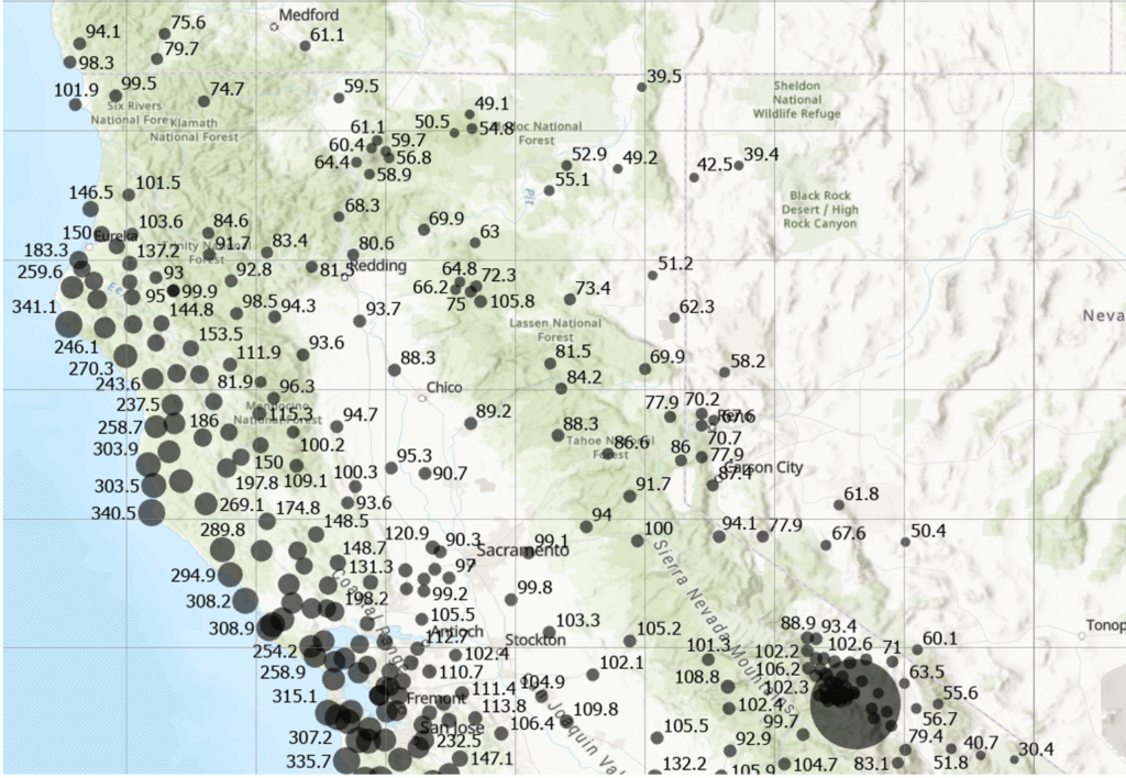
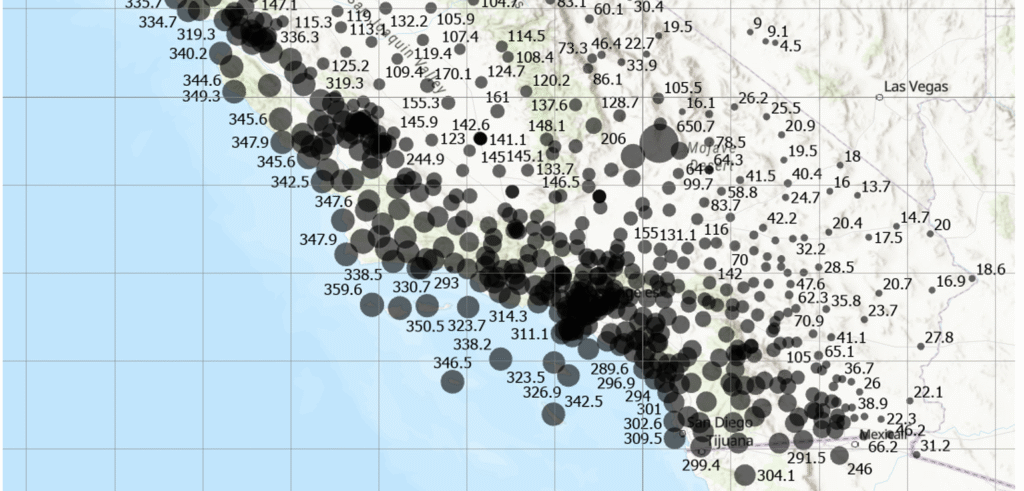
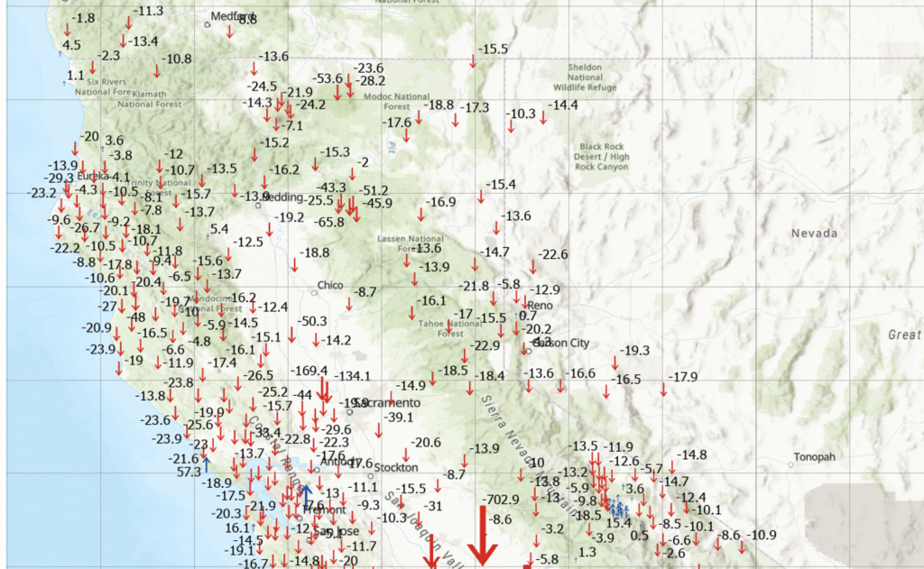
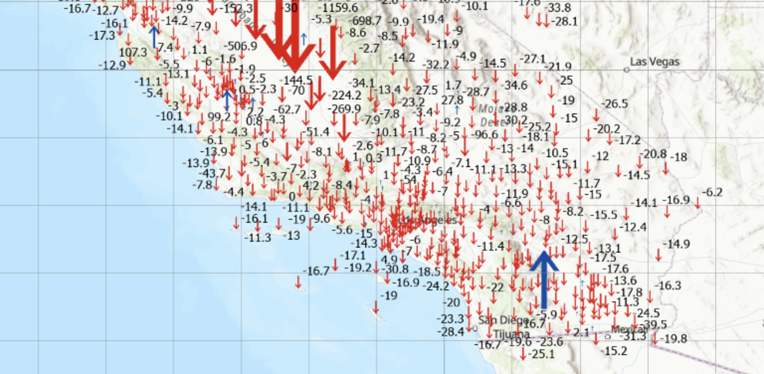
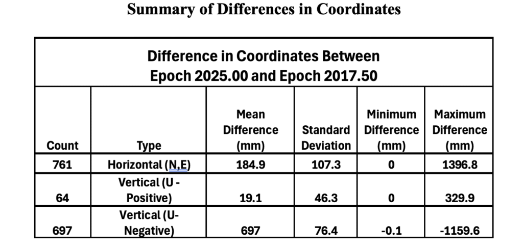
I downloaded the table of stations with their various coordinates and plotted the differences between the new CSRC Epoch 2025.00 NAD83 (2011) and the previous CSRC Epoch 2017.50 (NAD83 (2011) for stations that were designed as operational stations in 2025. The following plots depict the difference in coordinates between Epoch 2025.00 and Epoch 2017.50. One can see that there’s a reason that California needs to periodically update the coordinates of the California Spatial Reference Network. Some of the horizontal coordinates have changed over 300 mm or around one foot. The vertical coordinate changes are not as large, but some do shift more than 4 cm.
Note: The plots do not include newer stations with less than 6 months of solutions (no velocities estimated) and defunct stations (stations in Epoch 2017.50 but no data before January 1, 2025.
Differences in horizontal coordinates (N, E) between Epoch2025.00 and Epoch 2017.50 (northern section). Differences in horizontal coordinates (N, E) between Epoch2025.00 and Epoch 2017.50 (southern section). Differences in vertical coordinates (U) between Epoch2025.00 and Epoch 2017.50 (northern section). Differences in Vertical Coordinates (U) between Epoch2025.00 and Epoch 2017.50 (southern section)
The image below provides some statistics about the differences in coordinates between Epoch 2025.00 and Epoch 2017.50.
Notes:
(1) Only includes operational stations in 2025
(2) Does not include newer stations with less than 6 months of solutions (no velocities estimated).
(3) Does not include defunct stations: in Epoch 2017.50 but no data before January 1, 2025.
This newsletter highlighted that the CSRC has adopted a new Public Resources Code–compliant geodetic datum (reference frame) for California: CSRN Epoch 2025.00 NAD83(2011), which replaces CSRN Epoch 2017.50 NAD83(2011). The updated datum incorporates secular (linear) tectonic motions across the North America–Pacific plate boundary, transient motions (such as coseismic and postseismic deformation and fault creep), vertical land motion (subsidence and uplift), and data from new stations established since Epoch 2017.50. Additionally, the new vertical datum provides a comprehensive set of California Orthometric Heights on the NAVD88 datum for all CSRN stations.
In essence, the CSRC has released three new datums. The first is tied to ITRF2020, the second to NAD83(2011), and the third to NAVD88. Transformation parameters are available between the first two datums. The NAD83(2011)-based datum satisfies California’s Public Resources Code requirements and is the recommended standard for geodetic control in the state. The NAVD88-based datum provides GNSS-derived California Orthometric Heights of 1988 (COH88).
These new datums will be added to the European Petroleum Survey Group (EPSG) database, the worldwide standard for coordinate reference systems (CRSs) and transformations. Each will receive a unique EPSG code, making it easy to reference and use. This will ensure that CSRN Epoch 2025.00 NAD83(2011), CSRN Epoch 2025.00 (ITRF2020), and COH88 Epoch 2025.00 (NAVD88) can be seamlessly integrated into industry software.
The CSRC report also noted that NGS has released a beta version of the modernized horizontal and vertical datums for the NSRS: NGS New Datums.
Once the modernized NSRS is fully published, and in response to the needs of California’s user community, CSRC will continue working to secure resources that support its partnership with NGS and ensure ongoing compatibility with national programs.
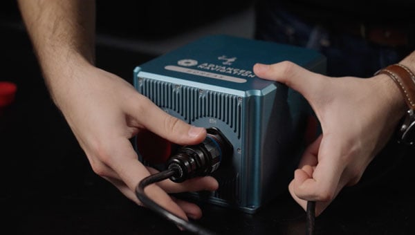
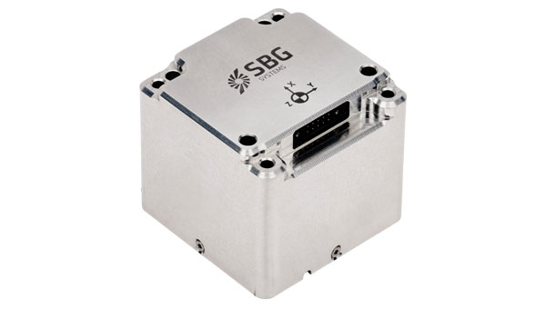
SBG Systems has announced the upcoming release of the Pulse-20 inertial measurement unit (IMU) and the commercial availability of the Pulse-80, expanding its IMU product portfolio to three performance levels.
The Pulse-20, described as a sub-miniature, industrial-grade IMU, will be available before year-end. The company now offers three IMU models designed for different performance requirements: the Pulse-20, Pulse-40 and Pulse-80.
Pulse-20 IMU
The Pulse-20 features built-in magnetometers for nine-degree-of-freedom measurements and includes CAN communication alongside serial connectivity. The compact unit targets applications requiring high performance in limited space.
The Pulse-40 represents tactical-grade performance, while the Pulse-80 delivers what the company calls FOG-level performance without the size, weight and cost associated with traditional fiber-optic gyroscopes.
All three models share the same software interface and undergo temperature calibration and qualification testing, according to the company.
The IMUs target multiple industries including unmanned vehicles, munitions guidance and navigation, electro-optical systems, mobile and surveying applications.
The Pulse-80 is currently available worldwide. The Pulse-20 will become commercially available later this year.
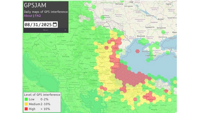
A plane carrying the European Commission President Ursula von der Leyen was targeted by GPS jamming while attempting to land at Plovdiv International Airport in Bulgaria on Aug. 31, according to a European Commission spokesperson.
Bulgarian authorities suspect Russia was responsible for the interference, European Commission Deputy Chief Spokesperson Arianna Podestà told CNN.
The Kremlin has denied the allegation. Spokesperson Dmitry Peskov told The Financial Times, which first reported the story, that the information was incorrect.
The plane landed safely despite the GPS disruption, with pilots reportedly using paper maps to navigate, according to a source familiar with the situation.
Von der Leyen was traveling as part of a seven-country tour of the European Union’s frontline states to rally support for Ukraine. The incident occurred as her charter flight approached the southern Bulgarian airport during her diplomatic mission to reinforce the bloc’s commitment to defending against Russian aggression.
Podestà told CNN that the incident highlighted the urgency of von der Leyen’s current trip to frontline member states, where she has witnessed daily threats from Russia and its proxies. The spokesperson noted it remained unclear whether attackers specifically targeted the flight or if it was caught in broader GPS interference operations.
Expert Insights:Searching for Resilience
This latest incident comes amid a dramatic surge in GPS jamming and spoofing attacks across the region since Russia’s invasion of Ukraine, creating an increasingly challenging environment for critical navigation systems.
European Commission President Ursula von der Leyen’s current tour through Poland, Bulgaria, Finland, Estonia, Lithuania, Latvia and Romania takes her directly through many of the continent’s GPS disruption hot spots. These nations have experienced some of the most severe interference with GNSS, making the timing of her defense-focused diplomatic mission particularly significant.
According to GPS World Editorial Advisory Board Member Mitch Narins, the current crisis represents the culmination of concerns that have been raised for more than twenty years. “Concerns and warnings regarding interference to GNSS have been raised for over two decades,” Narins explains. “Despite these concerns, attempts to install and upgrade alternative or complementary PNT systems on the ground and in aircraft have failed and resulted solely in increased investment in satellites and their signals, all of which are extremely low-power by design and vulnerable to interference.”
“Regrettably, the substantial financial resources required to fund these satellite projects have pushed for discontinuance of resilient ground-based alternatives and to consider them ‘cost offsets,’” he notes. The economic incentives have favored satellite constellation expansion over diversification, despite the vulnerabilities of space-based systems.
When it comes to alternative options, Narins explains, “For the cost of building and launching a single GNSS medium-Earth orbit (MEO) satellite, one could fund the replacement or installation and operation of many resilient ground-based systems for many years.”
The current approach to PNT systems represents a departure from fundamental systems engineering principles, according to Narins. “When initiating a customer need analysis, a systems engineer does not begin with the solution and work backwards,” he emphasizes.
Instead, the focus should be on meeting actual requirements: PNT systems must “always” provide the accuracy, availability, integrity and continuity of services necessary to support safety, security and economic well-being across thousands of use cases spanning every critical infrastructure sector.
“Therefore, resilience must be a critical part of a PNT system’s performance if it is to be considered a potential solution,” Narins said. Rather than pursuing interoperability between GNSS constellations — which still leaves users dependent on inherently weak satellite signals — the industry should have prioritized diverse solutions from the outset.
He added, “This is not a simple problem with a single, simple solution, but it is time to start thinking about resilience first and leaving the identification of solutions to a proper system engineering process.”
New Ways to Counter EW Threats
The dangerous GPS jamming of the plane carrying carrying European Commission President Ursula von der Leyen can be alleviated with advanced technology, according to Michael Biercuk, CEO of Q-CTRL, developers of quantum-based navigation systems:
“The incident regarding the European Commission President’s plane has raised GPS denial from inconvenience to a strategic security threat. This is why we’ve focused our quantum tech development efforts on building resilient quantum navigation systems truly immune to jamming and spoofing. This technology is not science fiction – it has been validated in flight to outperform the best existing GPS backups by up to 100X. Through our partnerships with Airbus, Lockheed Martin, and others we’re ready to help build resilience for European transport, defense and commerce.”
Chris Shaw, CEO and co-founder of Advanced Navigation also spoke on the incident, commenting “The answers to the GPS crisis are already here,” said Chris Shaw, CEO and co-founder of Advanced Navigation, which specializes in anti-electronic warfare navigation technology. “The problem isn’t innovation, it’s stagnation. GPS alone can no longer be treated as a reliable source of truth. What’s needed is a resilient architecture — inertial-centered and fused with multiple sensors — that keeps systems operating even when signals are denied or manipulated.
“The reality is that adversaries are moving at the speed of code, while government procurement still runs at the speed of bureaucracy. That gap is a national security risk. Unless governments adopt a new model of rapid integration and real-time collaboration with industry, they will continue to be outpaced.
“This isn’t optional. Survivability in GPS-contested environments depends on prompt deployment of inertial navigation. The companies pushing this forward aren’t just keeping up, they’re rewriting the playbook — and the cost of delay is measured in mission failure and compromised sovereignty.
“Ukraine has shown what’s possible. By demanding real-time software updates and rapid hardware upgrades in close collaboration with industry, its forces are reshaping autonomy, navigation, drone swarms and integrated defense systems at an unprecedented pace — allowing them to outpace adversaries.
“So why aren’t we applying this model more broadly beyond the battlefield? The solutions exist, with inertial navigation at the core. The real question is whether we’ll act before the cost of delay becomes irreversible.”
The GPS Collapse isn’t fiction — it’s a warning of what happens when action is delayed.