QantasLink, Australia’s largest regional airline, has selected the FreeFlight 1203C SBAS/GNSS sensor for retrofit into its DHC-8-200/300 series of aircraft.
QantasLink paired the 1203C with the Dash 8’s TDR-94D Mode-S transponders.
“We’re pleased to demonstrate once again that there are practical ADS-B solutions for aircraft that have been in service for a while,” said Pete Ring, FreeFlight Systems’ director of Sales and Marketing. “We are proud to supply QantasLink with a straightforward, retrofit solution that extends the life of their DHC-8 fleet.”
As a certified ADS-B position source approved for all ICAO jurisdictions, the integrated 15-channel 1203C SBAS/GNSS sensor is part of a fully rule-compliant ADS-B Out system when paired with a compatible certified Mode S transponder like the TDR-94D. Providing reliable service to fleets worldwide, the 1203C also serves as the approved position source for CPDLC, TAWS/FMS, RNP and other NextGen applications.
Designed for business, regional, airline transport and heavy rotary wing aircraft, the 1203C provides state-of-the-art aviation GPS technology in a proven package. The 1203C allows customers to take advantage of the benefits of NextGen without the need for extensive and costly avionics upgrades.
Founded in 2001 and based in Texas, the company pioneered the first certified aviation WAAS/GPS receiver and the first rule-compliant UAT ADS-B system. FreeFlight Systems designs and manufactures high-performance avionics for flight safety. The solutions deliver substantial safety, cost, environmental and other benefits from the NextGen airspace transformation.
Trimble’s Irrigate-IQ now has “uniform corner,” which allows farmers to apply a consistent amount of water on the area covered by a center-pivot corner arm.
The solution prevents over- or under-watering through a uniform application, which can reduce crop stress, promote better nutrient absorption due to reduced run off and leaching, and ultimately improve crop quality and yield. In addition, it enables farmers to optimize water use. This can be beneficial for farmers located in areas with limited water resources or with water restrictions.
Irrigate-IQ uniform corner uses advanced algorithms that enable consistent water application regardless of the position of the corner arm. Whether the corner arm is starting to extend, fully extended, or folding back, Irrigate-IQ uniform corner minimizes the risk of overlaps or gaps in application.
Because it controls each individual nozzle based on the desired application depth and the position of the corner arm, uniform corner provides the highest level of accuracy to achieve maximum uniformity across the entire area covered by the corner arm. In addition, Irrigate-IQ uniform corner works with multiple brands of corner arm equipment.
“Most farmers invest in a corner arm system in order to extend their irrigable land. However, typical systems do not provide consistent watering,” said Neil Douglas, Irrigate-IQ market manager for Trimble’s Agriculture Division. “This means they are not optimizing their water resources, and potentially damaging their crop and reducing yield by over- or under-watering it. Irrigate-IQ uniform corner allows farmers to extend the capabilities of their current corner arm through consistent water application to achieve the greatest return on their investment.”
Farmers can set the field depth and let the corner arm run, or they can add Irrigate-IQ monitor and control so they can remotely manage their whole pivot. For farmers who choose to add monitor and control, they can use the Connected Farm Irrigate app to remotely keep track of pivot status, or to turn their pivot on or off or change its direction.
Irrigate-IQ uniform corner is expected to be available worldwide in the first quarter of 2016.
Spirent Communications and Oasis Smart SIM have created a strategic partnership to remove connectivity and network provisioning barriers for the rapid development of connected products and devices, such as cameras, smart vehicles, logistics and production goods.
Spirent Communications is a provider of device intelligence solutions, and Oasis Smart SIM is a global Universal Subscriber Identity Module (USIM) connectivity and management provider.
The partnership marks both firms’ entry into the connected Internet of Things (IoT) business, which analyst Gartner forecasts will result in 6.4 billion connected devices worldwide in 2016, reaching 20.8 billion by 2020.
Beefore launching the new product, Spirent and Oasis undertook extensive research into the hurdles that original equipment manufacturers (OEMs) face in making diverse connected products, ranging from white goods in the kitchen to those used in animal management, suitable for sale in world markets. It became clear that old technologies and business models based on use of the traditional SIM were not suitable for IoT device activation and subscription provisioning on a global scale.
The partnership between Spirent and Oasis will introduce a two-click software solution, including USIM functionality, that OEMs can embed into products for seamless cellular service activation in any of the world’s markets, as well as life-cycle management.
The new product will be showcased on the stands of Spirent (Hall 6, Stand 6J37) and Oasis (Hall 2, Stand 2D13/15/19MR) at Mobile World Congress, in Barcelona (22-25 February, 2016).
“Spirent and Oasis have teamed up to help manufacturers build better and smarter products for the connected world,” said Dennis Juul Poulsen, general manager of Spirent’s IoT Connectivity and Subscription Management business. “Be it a connected truck or a pair of smart running shoes, OEMs in whatever vertical market now have a solution that provides customers with seamless instant connectivity and the freedom to choose whatever cellular service provider they wish.”
“Spirent’s unique automatic access point name (APN) setup and remote subscription management solution with Oasis’ embedded smart USIM functionality is a game changer in connected products and devices,” said Olivier Leroux, CEO of Oasis Smart SIM. “OEM vendors now have a leaner way to manufacture, distribute and maintain connected products compared to solutions centered on the traditional SIM.”
Topcon Positioning Group has added the FC-5000 to its line of data controllers for construction and surveying professionals. The 7-inch sunlight-readable display field controller is designed to provide operators a larger, more versatile and faster handheld computer for the modern construction site.
“At 7-inches, the FC-5000 has the largest handheld data controller screen in our product line,” said Ray Kerwin, director of global surveying products. “The display has a capacitive touch interface — with finger, glove, small tip stylus and water capable options — that is optically bonded to increase visibility. With the press of a key, a user can change the orientation of the screen from portrait to landscape to increase visibility when viewing maps or drawings.”
The controller is compatible with all Topcon GNSS receivers and total stations — operating MAGNET Field, Site and Layout software.
“The FC-5000 comes with two built-in cameras — an 8 MP camera with autofocus and LED flash for field photography — and a 2 MP camera on the front for video meetings. With 64GB of flash storage, users can store hundreds of photos in the unit, which can be easily transferred to any computer or USB stick,” Kerwin said.
Additional features include an optional 4G LTE cellular modem, internal GPS navigation, Bluetooth and Wi-Fi, and a battery life of 10-plus hours.
In September 2013, the night before he won the prestigious ION Kepler Award, Dr. John Betz and I were enroute to an ION (Institute of Navigation) dinner when he casually mentioned that he was thinking about writing a book. The natural journalistic inquiries about subject and timing brought a surprising response. The draft of the first chapter was already complete and it would be about PNT space systems or GNSS (Global Navigation Satellites System) if you will. Not just GPS, but all space-borne (satnav) PNT (position, navigation and timing) systems and augmentations.
When I asked John exactly why he was writing the book he replied, “I am writing the book for several reasons. First, there is a shortage of books that uniformly treat all satnav systems, rather than emphasizing a single system. There are a lot of common and complementary characteristics that become clear when all are treated in a uniform and consistent way.
“Second, this is a chance to provide an integrated perspective on satnav systems engineering. Lastly, I’ve learned a lot in the last 17 years, and I want to document it in an organized way.”
I, of course, offered to help in any way I could. I mentioned that I would very much like to review the book when it was finished. Not too much was said about the book until the next year at the very same event, when John mentioned the book would be ready for publication in the first quarter of 2016. Again I offered to review the book, and this column is that promised review.
First of all, there can be no doubt that Dr. John Betz, a MITRE Fellow, is qualified to author this engineering tome about all matters pertaining to space-borne PNT. Indeed, if I were to fully recite his impressive curriculum vitae, it would be longer than the entire space allocated for my column, so I will make do with the short paragraphs that accompanied the Kepler Award.
Dr. John Betz, winner of the ION 2013 Kepler Award.
“Dr. John Betz contributed to the international interoperability and compatibility efforts leading to the design of the GPS L1C civil signal. His Binary Offset Carrier (BOC) technique is used for the GPS M-code signal, and adopted by satellite navigation systems developed by Russia, Europe, China, Japan and India.
“Since 1997, Dr. Betz has worked on the NAVSTAR GPS and also on international negotiations concerning compatibility and interoperability of GPS with the world’s satellite navigation systems. For his role in the United States/European Union negotiations that established compatibility and interoperability between GPS and Galileo in 2004, he received the U.S. State Department’s Superior Honor Award.
“More recently, Dr. Betz provided critical analysis related to GPS modernization, recommending affordable enhancements to address increasing threats and to shape the architecture of military GPS for decades to come. Col. Bernard Gruber, [then] director of the GPS Directorate said, ‘I can think of no one else in the past two decades, military or civilian, who has influenced this critical national asset to the same degree as Dr. Betz’.”
I asked Dr. Betz what he liked most about writing the book, what he disliked the most, and would he do it again?
“Don, some chapters just flew — it was really fun to write them,” he said. “And I really like the color graphics, even in the print edition. It was challenging to find the time, given my work schedule. That was probably the most difficult part. It’s amazing when I look back. It was a little more than two years from start to submitting the manuscript. I had planned on 400 pages and it’s 640 pages. And yes, I would do it all again.”
Scope
The scope of this engineering reference is exhaustive in nature where PNT is concerned. The work is balanced between original content and a compilation of academic papers by numerous expert authors. Certainly, Dr. Betz gives credit where credit is due; he often recommends other volumes, texts and papers for enlightenment. However, for me his personal and professional insights and clear explanations of highly technical issues are what make this a compelling volume.
In his introduction, Dr. Betz describes his effort:
“This book describes satellite-based navigation and timing (satnav), the engineering of systems that transmit radio frequency (RF) ranging signals from a constellation of satellites so that a passive receiver can determine time and its position. The intent of this book is to provide a consistent and integrated depiction of the engineering behind satnav.”
If a PNT or GNSS constellation, or even a small group of satnav vehicles, is in orbit today — such as WAAS, EGNOS and QZSS — John describes their makeup and contribution to the overall PNT solution in great detail that is understandable to both the academic and layman alike.
Insights
I have personally been involved with satnav in one fashion or another for 40 years. Frankly, I thought I was well versed in the subject. Yet, in every chapter of John’s book, I either learned something new or had an issue explained that I obviously did not understand quite as well as I thought. There is something for everyone interested in satnav in this wonderful book, regardless of their level of involvement or sophistication with PNT.
References
The book contains exhaustive tables, references, figures and formulas for all levels, which is why I am sanguine this book will become an invaluable reference and textbook for the military as well as any university dealing with educating students concerning satnav and PNT issues.
When I finished reading the 640-page volume, I had added more than 40 blue “stickies” to mark figures or tables for future reference.
This book is a treasure trove for PNT engineers and satnav experts, but it’s readability is such that even if you are only slightly curious about how space-based PNT works, you will find it an educational and enjoyable read.
For instance, on page 29, Table 2.1 summarizes the nominal constellation characteristics, 16 for each system, between GPS (US), GLONASS (Russian), Galileo (European) and the BeiDou (Chinese) constellations. While this will probably only serve as riveting cocktail repartee at something like an ION function, it is also just good to know, fun facts if you will. It might even serve as a Jeopardy category one day.
Bottom Line
Dr. Betz begins his lengthy but enjoyable tome with an explanation of satnav; takes the reader through the various space-borne PNT systems and augmentations on orbit today; describes the signals, the errors and the various pluses and minuses of each system; and then delves into PNT receiver design and describes how each signal is received and utilized.
After reading the book I asked Dr. Betz if he thought or hoped the book would be used as a textbook. He replied, “I hope it gets used in multiple ways. It can certainly be used by practicing engineers as a reference and for in-depth exploration. I hope its contents and structure make it useful as a textbook, because the book includes theoretical and applied questions at the end of many chapters that should help students learn how to extend and apply the theory and practice laid out in the book. Also, I hope its structure is conducive for use in teaching.”
While the jury is still out on whether this is a engineering textbook, a satnav reference manual, a primer on modernized PNT, or perhaps a compendium of all three, if you care at all about modern-day GNSS and all it enables, this book should be in your library.
Until next time, happy navigating, and I hope you enjoy the book.
Next generation for precise scientific and geodetic applications
The PolaRx5 offers 544 hardware channels for robust and high-quality GNSS tracking. The receiver supports all major satellite signals including GPS, GLONASS, Galileo and BeiDou, as well as regional satellite systems including QZSS and IRSS. Septentrio’s Advanced Interference Mitigation (AIM+) technology enables it to filter out both intentional and unintentional sources of radio interference, from narrowband signals over high-powered pulsed signals to chirp jammers and Iridium interferers. Septentrio’s APME+ multipath mitigation technology eliminates short delay multipath without introduction of bias and guarantees superior measurement quality. The user can deactivate APME+ to obtain unmodified measurements.
Bentoni is a positioning antenna for all of the global public satellite constellations: GPS, GLONASS, BeiDou and Galileo. It is designed to be used in trackers, portable devices, network components, drones and wearable electronics. It offers high performance and maintains good isolation in situ within a device. Bentoni is a flexible FPC antenna in Antenova’s flexiiANT product range. They are supplied with an I-PEX MHF connector and a 1.13 mm RF cable in a choice of three lengths. They can be folded to save space in operation within a device, with the aim being plug-and-play simplicity. The antennas are self-adhesive mounted so that they can easily be fixed inside an electronic device.
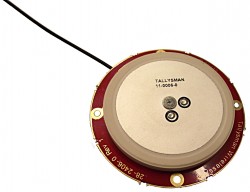
The Tallysman TW2926 antenna is an unhoused OEM version of the TW2920, designed for simultaneous reception of L-band correction signals and all of the upper band GNSS signals, including GPS L1, GLONASS G1, Galileo E1 and BeiDou B1. The TW2926 is 56 millimeters in diameter and has four drilled plated holes for secure mounting within customers’ products. It can be custom tuned to ensure optimal performance within an enclosure. The 1-dB bandwidth of both the TW2920 and TW2926 covers 1525–1559 MHz for the L-band downlink and 1559–1610 MHz for the upper-band GNSS. The LNA provides 28-dB of gain. The antennas employ Tallysman’s Accutenna technology, which provides strong cross-polarization rejection for greatly improved multipath rejection, low axial ratio and tight phase center variation.
The Near Field Communication (NFC) 88NF100 controller with active load modulation (ALM) is desgined to support the smallest antenna sizes critical to mobile, the Internet of Things (IoT), wearable and automotive applications. Adhering to NFC Controller Interface (NCI) Technical Specification version 1.1, the 88NF100 provides an extended operating range and is extremely energy efficient to enable extended battery life for power-critical applications. ALM technology supports the smallest antenna sizes to enable OEMs to implement NFC capabilities into small form-factor designs. The controller has extremely low power operation in polling mode to provide increased battery life for power critical applications and three single-wire protocol (SWP) interfaces to secure element (eSE) devices for secure payments. The two-pin antenna interface supports a maximum distance of two meters between the chip and antenna.
Designing Better Maps: A Guide for GIS Users, second edition, is an updated and comprehensive guide to creating maps that communicate effectively. Cartographer Cynthia A. Brewer covers the basics of good cartography, including layout design, scales, projections, color selection, font choices and symbol placement; she also describes her ColorBrewer application, an online color selection tool. The second edition includes a new chapter on map publishing. One reviewer wrote, “It is also worth a look by experienced cartographers who seek a refresher and a few new tips.” Brewer is a professor and chair of the Department of Geography at Pennsylvania State University and map and atlas design consultant.
Eos Pro Tools is tightly integrated with google map
Eos Pro Tools is a comprehensive RTK NTRIP app for Android that works with its Arrow line of RTK GNSS receivers. An Arrow GNSS receiver combined with the NTRIP app turns an Android smartphone or tablet into a powerful data collector capable of recording 1-centimeter accurate GIS data in real-time. The app, named Eos Tools Pro, has user-configurable audible and visual alarms to alert the user of high PDOP, lost RTK correction, unacceptable correction age and several other important metrics. It supports all current and future constellations (GPS, GLONASS, Galileo and Beidou). Detailed satellite information such as a skyplot that plots each visible satellite, whether it’s being used or not, and signal strength bar graphs from each constellation are also displayed. Finally, a terminal screen displays the NMEA data flowing and allows the user to send commands to the receiver.
Lightweight, ergonomic design for the mobile workforce
The 7-inch Algiz RT7 Android tablet is fully rugged, meeting stringent MIL-STD-810G U.S. military standards for protection against drops, vibrations and extreme temperatures. Its IP65 rating means that it’s waterproof as well as fully sealed against sand and dust. The tablet comes with a built-in accelerometer, gyroscope and e-compass as well as a stand-alone u-blox EA-7M GPS receiver for navigation, along with built-in Qualcomm IZat location services.
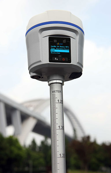
The i80 GNSS receiver computes a true triple-frequency real-time kinematic (RTK) tilted pole solution using all four worldwide and multiple regional constellations, providing a future-proof sub-centimeter RTK solution to surveyors and contractors. Without the need of a data collector or computer, the i80’s LCD graphic user interface allows for common workflow operations, such as static logging, autobase, autorover and UHF channel selection, to be easily performed. The CHC i80 incorporates dual hot-swappable batteries, allowing for days of uninterrupted work. While small and lightweight, it is packed with a full array of sensors and modules: multiple micro-electrical-mechanical (MEMS), internal Tx/Rx UHF, multiband cellular modem, Wi-Fi, Bluetooth, serial and USB.
All-in-one GPS, GNSS and RTK Data Collector Series
The SXPro series is built for mobile survey and GIS users for applications such as water, electric and gas utilities; transportation; mining; agriculture; and forestry. The professional-grade rugged handheld receivers include a battery life of more than 10 hours on a charge as well as a large outdoor-viewable touchscreen. The handhelds are rated IP65 for protection against water and dust, and equipped with a 5-megapixel autofocus camera and Microsoft utilities. The SXPro RTK (real-time kinematic) model offers 220 multi-constellation channels for centimeter accuracy with RTK networks. The SXPro GNSS offers 372 multi-constellation channels for sub-meter accuracy with SBAS corrections.
New point cloud analysis and visualization capabilities
The latest release of ENVI software adds lidar point cloud analysis and visualization capabilities that previously were only available in the ENVI lidar software package. ENVI 5.3 offers users a single software interface to work with hyper-spectral, multi-spectral, panchromatic and lidar data. The out-of-the-box functionality includes 3D point-cloud visualization, derived terrain product generation (such as digital elevation models) and lidar analytics such as viewshed line-of-sight calculation. For users who need point-cloud or terrain products in an area where collecting lidar is not feasible or is too expensive, the ENVI Photogrammetry Module is able to generate synthetic 3D point clouds from stereo optical imagery to take advantage of existing imagery archives. The dimension of time can be critical for a thorough geospatial analysis of an area, and the new ENVI release has added enhancements to the Spatio-Temporal analysis toolset. Spatio-Temporal analysis visualizes change and derives statistics from data over time, enabling users to observe past events to better predict upcoming activities.
The eight-rotor DJI Agras MG-1 UAV can load more than 10 kilograms of liquid for crop-spraying and can cover between seven and 10 acres per hour — more than 40 times more efficient than manual spraying. It can fly up to eight meters per second and adjusts spraying intensity to flying speed to ensure even coverage. It is dustproof, water-resistant and made of anti-corrosive materials. It features DJI’s flight-control system and microwave radar to ensure centimeter-level accuracy. During flight, the drone scans the terrain below in real time, automatically maintaining its height and distance from plants to ensure application of an optimal amount of liquid. The drone’s intelligent-memory function means after the Agras MG-1 is brought back to base for refill or recharge, it will return to its last memory point to pick up spraying where it left off.
The EXCIPIO is an anti-drone system that uses a drone to shoot out a net to capture another drone.The EXCIPIO Aerial Netting System is comprised of a UAS equipped with a first-person view camera and a net-firing gun. When the EXCIPIO has reached the threat target, it fires a net, then can either release the net with the target ensnared or keep the net tethered. Though the initial system concept was focused on intercepting and neutralizing an airborne UAV, the conceptual applications have expanded to include manned aircraft, ground vehicles, people and animals (whether airborne or on the ground).
The March 23 program at the Crowne Plaza Hotel, San Francisco Airport, focuses on a fast-changing landscape where automakers and Silicon Valley technology companies are crafting and beginning to roll out their strategies for the autonomous car. Keeping on top of the latest technology, early adoption trends, worldwide markets, liability factors and regulation will be critical in a sector previously known for long product design cycles.
Key topics addressed: Advanced driver assistance systems (ADAS) and autonomous vehicle technologies; solving the high cost of rolling out autonomous systems; investment approaches; testing; innovative players; consumer expectations; market-sector differentiation and strategies to exploit them; the regulatory picture.
Paul Drysch, global director, Connected Car for Jasper Wireless, is the conference chair. Panel moderators include Steve Wollenburg, co-founder and vice president, Business Development, Automatiks; Phil Magney, founder & principal, Vision Systems Intelligence; Derek Kerton, founder, The Kerton Group, Telecom Council, Autotech Council; Jan Hellaker, program director, DRIVE SWEDEN; and Adrian Pearmine, national director for smart cities and connected vehicles, DKS Associates.
The conference also features a reception on the evening before, a hosted luncheon, and a post-program exhibit and reception.
CEVA Inc. has introduced the Dragonfly reference platform to accelerate the design of low-data-rate machine-to-machine (M2M) and Internet of Things (IoT) communication applications, including standalone wearables, smart grid, surveillance systems, asset tracking, remote monitoring systems, connected cars and smart utilities.
The Dragonfly multifunction platform is enabled by the recently announced CEVA-XC5 and CEVA-XC8 digital signal processor (DSP) cores and accompanied by the hardware and software components required to rapidly design machine-type communications (MTC) systems.
The platform supports GPS, Wi-Fi and other IoT-related communications standard set to be deployed for M2M communication as well as existing and emerging LTE MTC releases and LPWAN standards such as LoRa, SiGFox and Ingenu. LTE MTC — LTE Advanced for machine-type communications — significantly increases battery life, reduces device complexity, and enhances coverage for low data rate machine-type communications.
At Mobile World Congress 2016, CEVA will demonstrate the Dragonfly reference platform running LTE Cat-0 and GPS concurrently on its silicon-based development platform together with test and measurement equipment from Keysight Technologies and a GNSS simulator from Galileo Satellite Navigation. Mobile World Congress takes place in Barcelona, Spain, Feb. 22-25. CEVA is located in Hall 6, Stand A50.
Dragonfly offers system developers a flexible platform that allows for optimal hardware/software system partitioning, combining a low-power vector communication DSP with a range of hardware co-processors. Such partitioning enables the software flexibility essential for upgradability and long service life of typical M2M devices, while delivering the power efficiency required to support extended battery life of up to 10 years.
As an example, for CEVA licensees developing M2M systems incorporating LTE Cat-1 or Cat-0 today, these systems can be easily upgraded to support LTE Cat-M or other future standards when available. The DSP can also be used to implement proprietary features for specific device use cases, such as seamless indoor and outdoor positioning concurrently with Wi-Fi 802.11n or LTE Cat-0, in a highly efficient manner.
“Our Dragonfly reference platform brings together all of the essential hardware, software and system integration components required by customers developing low-power machine-type communication solutions, in a highly cost and power efficient manner,” said Michael Boukaya, vice president and general manager, Wireless Business Unit at CEVA. “We have leveraged our deep expertise in low-power baseband processing and complemented it with a range of software offerings to deliver a platform that is highly customizable and flexible for developing a broad range of IoT and M2M products, quickly and efficiently.”
The Dragonfly reference platform includes the vector communications DSP and all the required co-processors and interfaces, together with software application layers and libraries, RTOS and drivers for MTC systems design. These hardware and software components are available for LTE MTC, Wi-Fi and GNSS standards. Also included is a 500-MHz silicon-based development system that includes all of these components together with RF front ends and a host interface.
Topcon Positioning Group has released a new excavator system with local positioning system (LPS) capabilities. The X-53i LPS is designed to provide a solution for machine-controlled excavation in sky-obstructed areas.
“The system is perfect for projects such as tunnel construction or working within existing structures using a total station and prism for precision,” said Kris Mass, director of construction product management. “It’s also versatile when GNSS positioning is available with the new Topcon MC-i4 receiver. Operators can easily choose which type of sensor to best use for the project.”
The system is compatible with the new Topcon GX-55 control box — a large sunlight-viewable LCD touchscreen with integrated LED light bars designed for continuous grade reference of the bucket’s teeth. “It’s the finest graphical experience for modern machine control with customizable audible tones, all wrapped up in a lightweight package for easy transfer and storage,” Maas said.
In the Woodland cemetery Carinthia (Friedensforst Kärnten), Austria, trees are precisely measured with the rugged Algiz 10X tablet PC and a GNSS/GPS rover.
Handheld Group is making its rugged Algiz 10x tablet computer available with Geolantis surveying software and a GNSS/GPS Rover as a solution for precisely locating burial sites in for woodland cemeteries.
In woodland cemeteries, people purchase a small plot to bury ashes in an urn near the base of existing trees. Each tree has a small plaque with the names of those whose ashes are buried there. The concept treats the forest with care and enables people to buy a tree location in advance for their funeral.
One customer who has already deployed this solution is the company Bestattung Kärnten which owns a specialized woodland cemetery. To make the urn space available for the sale, the trees first need to be identified, located and registered. The high demand for forest burials in the woodland cemetery required Bestattung Kärnten to find an efficient technology for the registration and management of trees in the cemetery.
Using combination of Geolantis surveying software and the Algiz 10X tablet in combination with a GNSS GPS rover worked for the company. These precise tools are now the basis for registering of what will later be sold as urn spaces.
Once a suitable forest is reclassified as a woodland cemetery, the identification of available trees begins. The ALGIZ 10X tablet’s ability to be operated with an external GPS antenna enables the employees of the funeral company to register trees in the woodland cemetery, including related master data, at any time day or night and regardless of weather. The tablet’s 5-megapixel camera can be used at the same time to create an image catalogue.
The plans — including the register — can be extended, edited and changed at any time. The large storage capacity allows the worker to gather huge amount of data.
The 10-inch display on the Algiz 10X, which is viewable even in direct sunlight, simplifies data entry. With the Geolantis software, even non-surveyors can create an individual register for the woodland cemetery trees.
Additionally, regular tree control can be performed with the Algiz 10X. The integrated u-blox GPS receiver makes it possible to use the tablet for navigation and documentation as part of the inspection work without an external GPS/GNSS receiver.
AgStudio can now read as-applied maps and production data from Connected Farm. Previously, AgStudio software users could only read harvest data from Connected Farm.
Users with current subscriptions to AgStudio software are able to communicate seamlessly with Trimble field devices and wirelessly transfer field data, as-applied maps and production data from planters, spreaders and sprayers as well as combines for harvest data.
The recent integration taps into the new Trimble Connected Farm file transfer API, which provides data sharing access with the Connected Farm solution, and offers AgStudio software users more flexibility in importing data from an even wider variety of company systems.
“This integration with Trimble’s Connected Farm solution allows our customers greater access to information that streamlines production management,” said Ted Macy, vice president of operations at MapShots. “Whether it’s variable rate seeding, variable rate fertility, or managing harvest data, AgStudio software users now can import even more valuable information and make decisions based on activities carried out by Trimble guidance and steering systems.”
Trimble’s Connected Farm solution combines industry-leading hardware and software to increase efficiency and enable better decision making. Together, the two companies allow agricultural providers to better manage production data.
“The integration with MapShots AgStudio software fits into Trimble’s Connected Farm strategy to provide growers a more complete picture of their field activities while allowing them a choice of software tools to analyze data and make production decisions,” said Pierre-Andre Rebeyrat, strategic marketing director of Trimble’s Agriculture Division. “We are excited to welcome MapShots to the growing list of companies that have taken advantage of the Connected Farm file transfer API.”
For further information, users can contact their regional MapShots sales representative at 678-513-6093 or e-mail MapShots at [email protected].
Mobileye, a developer of vision and data analysis for Advanced Driver Assistance Systems (ADAS) and autonomous driving, has introduced a new mapping technology development called Road Experience Management (REM).
REM enables crowd-sourced real-time data for precise localization and high-definition lane data that forms an important layer of information to support fully autonomous driving.
Mobileye is engaged with General Motors to integrate REM into existing program launches in an expedited timeframe, as part of GM’s heightened partnership with Mobileye. In addition, on Jan. 5, Mobileye signed a Memorandum of Understanding with Volkswagen and announced a strategic partnership to explore and integrate REM into Volkswagen’s fleet.
The technology is based on software running on Mobileye’s EyeQ processing platforms that extracts landmarks and roadway information at extremely low bandwidths, approximately 10 kb per kilometer of driving. Additionally, backend software running on the cloud integrates the segments of data sent by all vehicles with the on-board software into a global map.
“We leveraged advanced artificial intelligence, used for creating environmental models from camera input, in order to create maps based on local coordinate systems while requiring very low bandwidth,” said Prof. Amnon Shashua, co-founder, chairman and Chief Technology Officer of Mobileye. “The low bandwidth of the model, and the fact that it requires only a camera, which is already available in most new car models as part of the trend towards growing driver assistance deployment, enables the map creation and update to be managed by a cooperative crowd sourcing mechanism.”
A third OEM customer of comparable size is expected to be announced later this year.
Shashua discussed the future of autonomous driving and road mapping at the Consumer Electronics Show in Las Vegas in January.
 QantasLink, Australia’s largest regional airline, has selected the FreeFlight 1203C SBAS/GNSS sensor for retrofit into its DHC-8-200/300 series of aircraft.