CartoDB is acquiring Nutiteq, a mobile mapping software development company with more than 15 million unique installations of its software development kit (SDK).
CartoDB is a location intelligence, data analysis and visualization company. Nutiteq’s clients include SeatGeek, LonelyPlanet, iRobot and Accenture, among others.
The acquisition will allow CartoDB to offer a cross-platform mobile mapping SDK, with a core rendering engine that complements its geo-analytics capabilities. The offline mapping and routing capabilities, along with an ability to work with a number of different sources of data, will enable enterprise customers to implement core location intelligence apps from a one-stop solution.
“We believe there is a big opportunity to rethink how we interact with location data on mobile devices. Most geospatial innovation has been pushed to the consumer space. Now enterprises will be able to make use of location intelligence on mobile devices with CartoDB,” said Javier de la Torre, CEO of CartoDB.
Nutiteq’s current SDK offering, including on-device analytics and vector rendering, will be augmented with CartoDB’s cloud location analytics and self-service products. This will provide a complete solution for companies building external facing apps or productivity tools on mobile.
“We’re thrilled for the potential to unlock massive value for location intelligence in virtually every industry,” said Jaak Laineste, CEO of Nutiteq. “It’s no surprise that people are moving from laptops to smartphones, and it’s safe to say that enterprises will be quick to follow.”
Laineste will lead the mobile division for CartoDB. The entire Nutiteq team will join CartoDB, with an office opening in Estonia, where Nutiteq is currently headquartered.
Garmin will introduce a new GPS smartwatch at Mobile World Congress, being held Feb. 22-25 in Barcelona, Spain. The vívoactive HR includes Garmin Elevate wrist heart-rate technology.
The vívoactive HR helps keep track of active moments throughout the day, counting steps and floors climbed, intensity minutes, monitoring sleep and featuring built-in GPS-enabled sports apps for walking, running, biking, swimming, golfing, paddle boarding, rowing, skiing and snowboarding.
The smartwatch uses 24/7 wrist-based heart rate data to calculate calories burned information as well as the intensity of fitness activities, providing proper credit for users’ array of workouts. With the Connect IQ store, users can personalize their vívoactive HR with free apps, widgets, watch faces and data fields.
The smartwatch will be showcased at the Garmin booth #CS 90.
“The vívoactive HR builds on the incredible versatility and multi-functionality of its predecessor by adding wrist-based heart rate and a barometric altimeter — allowing it to track even more data essential to workouts and day-to-day activity,” said Dan Bartel, Garmin vice president of worldwide sales. “All your efforts to stay active are accounted for from taking the stairs at the office to going on a run or ride.”
Featuring Elevate wrist heart rate technology1, the vívoactive HR provides 24/7 heart rate monitoring and eliminates the need for a chest strap. Using the heart rate data the vívoactive HR quantifies the intensity of fitness activities and allows users to monitor their progress against aerobic activity goals recommended by leading health organizations like the American Heart Association.
The vívoactive HR’s always-on, touchscreen, sunlight-readable Garmin Chroma Display lets users track activity and stay connected anytime, anywhere. Its built-in GPS-enabled sports apps include:
Running – Using a built-in accelerometer and GPS users can track runs either indoors or out. Additional features include Auto Lap, Auto Pause, and vibration alerts for heart rate, pace, run/walk intervals, and more. Post-run summaries include stats such as total mileage, calories, average pace and overall time.
Cycling – The cycling app measures time, distance, speed and calories. It is compatible with speed and cadence sensors, and the Varia® lights and radar (sensors and radar are sold separately).
Pool Swimming – In addition to tracking total and interval time, distance, pace, stroke count and stroke type, the swimming app also features easy pausing for rests, complete with rest timers, and can calculate swolf, a measure of swimming efficiency.
Golfing – Users can view a simplified view of the green, measure shot distance and be pointed in the right direction with PinPointer while golfing on one of the 40,000 course maps worldwide available for download from the Garmin golf course database.
Stand Up Paddleboarding and Rowing – Users can easily track and view pace, time, distance, stroke count, stroke rate and distance per stroke. When using an indoor rowing machine, users can track time, stroke count and stroke rate.
Skiing and Snowboarding – The skiing and snowboarding app measures 3-D speed by calculating the speed and distance on an incline versus latitude and longitude. It also provides splits automatically and features Auto Pause, which freezes the timer automatically when users stop or ride the lift.
The vívoactive HR also includes Garmin Move IQ, a new feature that continuously monitors for periods of sustained activity. With Move IQ, the vívoactive HR automatically recognizes walking, running, biking, swimming and elliptical training. Users can easily track their exercise throughout the day without needing to start a timed activity. Once synced with Garmin Connect, users can review their full day of activity in a convenient Timeline view.
The vívoactive HR will begin shipping in Q2 for a suggested retail price of $249.99. It will be available in regular and extra-large fit black bands. Accessory bands will be available in black, white, force yellow and lava red for a suggested retail price of $29.99 each.
Each month, the Federal Aviation Administration (FAA) receives more than 100 reports from pilots and others who spot what appears to be an unmanned aircraft (UAS) flying close to an airport or a manned airplane. It’s become a serious safety concern for the agency, and a potential security issue for the Department of Homeland Security (DHS).
In addition to the FAA’s ongoing outreach and education efforts, an additional step toward a solution is to detect and identify these “rogue drones” and their operators. Recently, the FAA partnered with DHS and CACI International to explore how the company’s prototype detection technology may help detect UAS in the vicinity of airports.
The main goal of the partnership is to safely explore procedures and processes for deploying and operating detection technologies in and around commercial airports.
SkyTracker. CACI’s proof-of-concept system — dubbed SkyTracker — employs radio frequency sensors at strategic locations around an airport in high, prominent locations. When the sensors detect frequencies unmanned aircraft typically use, it triangulates the signals and determines the location of both the UAS and the operator.
Under a Pathfinder agreement with the FAA, CACI successfully tested its system at the Atlantic City International Airport from Jan. 25 to Feb. 2. It was the first UAS detection research in a commercial airport environment.
A total of 141 operations were executed over five days — 72 with a UAS on the ground and 69 with different small UAS in flight.
The SkyTracker concept.
“SkyTracker successfully identified, detected, and tracked UAS in flight, and precisely located drone ground operators — all without interfering with airport ground operations,” said CACI CEO and president of U.S. Operations John Mengucci. “We are very proud to partner with the FAA and DHS to help ensure national airspace safety from the escalating UAS threat.”
“The explosive growth of the unmanned aircraft industry makes evaluating detection technologies an urgent priority,” said Marke “Hoot” Gibson, FAA senior advisor on UAS Integration. “This research is totally aimed at keeping our skies safe, which is our number-one mission.”
“Working with the FAA, the DHS Science and Technology Directorate is proud to provide our expertise in testing and simulation of technologies to better address the safety and security challenges posed by unmanned aerial systems,” said DHS Deputy Under Secretary for Science and Technology Robert Griffin.
In the coming months, engineers from the FAA, DHS, CACI and the University of Maryland (UMD), which also was a partner in the evaluation, will work together to compile the data for a final report by August 2016.
Malicious drones. Research on UAS detection systems may go beyond addressing the FAA’s concerns with the safety of UAS in the nation’s airspace. The effort also may contribute to keeping the skies safe from “bad actors” who want to use unmanned aircraft for malicious purposes.
To that end, the FAA signed a Memorandum of Understanding (MOU) with DHS in December to collaborate on the safe integration of UAS into the U.S. aviation system.
Australia’s Civil Aviation Safety Authority (CASA) has implemented a GNSS equipment mandate for all aircraft flying in the country, regardless of state of registry. The mandate is designed to align Australian operations with global standards set by the International Civil Aviation Organization (ICAO) for Communications, Navigation, Surveillance and Air Traffic Management (CNS/ATM).
The changes include the requirement that all aircraft operating under instrument flight rules (IFR) must now be equipped with GNSS avionics meeting TSO C129, which enables compliance with Required Navigation Performance (RNP) 1 terminal area and RNP 2 continental en route operations that begin May 26.
GNSS is the enabling technology for both performance-based navigation (PBN) and automatic dependent surveillance-broadcast (ADS-B) in Australia and will affect all IFR aircraft. Applying both PBN and ADS-B over the whole of Australia will permit:
Increased safety as air traffic control surveillance will be available over the whole of Australia at higher levels, and with substantial coverage at lower levels.
Flexi-route—a system that optimizes aircraft routes according to the latest weather and location of other aircraft
Reduced separation distances, greater fuel efficiency, lower flight times and reduced congestion at busy aerodromes.
To help foreign-registered aircraft operators in meeting the new requirements, transition arrangements are available for a two-year period. Operators who need the extension must complete an online form before their first flight in Australia on or after May 26.
To facilitate RNP operations within Australia, CASA has developed an acceptable means of compliance document.
The GNSS mandate will see ground-based navigation capability reduced by about 50 percent, with the decommissioning of about 190 ground-based navaids. The remaining network of navaids will form the GNSS backup navigation network.
Leica Geosystems has released the Leica Ultra underground service locating system for site engineers and underground utility specialists who need to trace buried utility lines accurately for safe underground excavations and utility surveys.
The locating systems helps users attain the highest accuracy to avoid costly mistakes, such as cutting utility lines or delaying project schedules during excavation work. By providing a wide range of transmitter mode frequencies, operators in segments such as power, water, gas or telecom can easily and quickly optimize the locator performance in any operating condition.
Users save time and effort by tracing utility depths and distances, Leica said. Multiple utilities in close proximity requiring a combination of adjustments can also be traced efficiently and with confidence.
Clear visualizations of line direction and depth indication are displayed on a large LCD interface. Users can easily interpret signal displays in all light conditions. Bluetooth enables quick connectivity so users can easily transfer data to a GIS data collector.
Topcon Positioning Group has released a new 3D dozer machine control system — 3D-MCMAX. The system is driven by dual IMUs (inertial measurement unit) designed to increase on-grade performance where speed and blade response is maximized, while eliminating the need for a mast on the blade.
The system uses Topcon 3D-MC2 technology with the dual IMU sensors and new, unique algorithms to deliver an integrated solution that locates the sensitive GNSS technology safely inside the cab instead of out on the harsh environment of the blade.
“The 3D-MCMAX is the next generation of dozer grading solutions that redefines the concept of machine control,” said Jamie Williamson, executive vice president and general manager of the Topcon Precision Automation Group. “It provides high-accuracy elevation, slope, and blade rotation sensing in an integrated configuration resulting in maximum speed, maximum control and maximum grading performance.”
The system is designed to let operators work confidently in rough or fine grade applications, slope conditions, and in restricted sight environments without the visual obstruction of masts or risks to hanging cables.
“This advanced system is a result of our clear understanding of how technology is driving the evolution of the construction world, and focusing our improvements on smart algorithms in our firmware and software to increase the productivity of the hardware — a full systems approach,” said Williamson. “The added bonus is a clean integration onto the equipment. Gone is the need for daily installation and removal of antenna, cables, and mast. With 3D-MCMAX, the operator just climbs on and gets to work — downtime is minimized.”
An Australian company that manufacturers GNSS echo sounders aided the aiders — leading a medical ship through uncharted waters in Papua New Guinea.
The CEESCOPE echo sounder enabled the ship to reach volunteers who were working to save the life of a newborn.
The ship, operated by YWAM Medical Ships Australia (YWAM MSA), visits remote villages in Papua New Guinea, giving communities access to life-saving medical and dental services. The village locations are accessed by river, and while often there is adequate tide information to help navigate, there are no available charts or bathymetry data for the passages upriver.
Without a navigable route to follow, the medical ships simply could not travel to locations where help is needed the most.
To solve this problem, YWAM decided to make its own charts, with help from CEE HydroSystems. Using a small, fast launch equipped with a CEESCOPE single-beam echo sounder and GPS hydrographic survey system, YWAM volunteer and master mariner Jeremy Schierer set out to find safe routes through vast river deltas ahead of the medical ship.
While surveying at high speed to maximize the area covered, Schierer executed reconnaissance patterns along the river while continuously updating the hydrographic survey plan based on the results seen.
Survey data gathered and processed in HYPACK acquisition software were exported to the navigation system of the ship to provide waypoints marking the safe passage route along the river. Used with available and observed tide data, the navigator of the vessel could confidently travel upriver without the risk of grounding.
The CEESCOPE is a one-box survey system that can be swapped between the two available 4.2-meter and 5.2-meter boats. It can be used without an acquisition PC on the survey launch if needed — all data recorded on the internal memory, and can run on its own battery power for an extended duration. With operation in remote areas on small boats, reliability and usability were key for YWAM.
YWAM also used the CEESCOPE with HYPACK from the wheelhouse to navigate the ship along the surveyed routes on custom electronic charts.
In the third year of YWAM’s operation in Papua New Guinea, Schierer recorded a staggering 3,400 kilometers (2,000 miles) of bathymetry to help navigate the Pacific Link. All of the rivers were uncharted before the ship traveled upstream. With incomplete tide-station coverage, determining the ship’s path was a complex calculation. Despite this, and complicated by a bore tide, YWAM was able to take its vessel 75 kilometers upstream in the Bamu River, Western Province, without published charts.
However, the most startling example of the benefit of the YWAM hydrographic survey approach took place in the second year of operation.
“Baimuru is up the Pie River from Port Romilly in the Gulf Province,” Schierer said. “The only previous known route took us about four hours through the rivers and required high tide and daylight.
“We went out with the CEESCOPE to see if we could find an alternate and more direct route to the open sea. We left the ship just before sunrise and went as far as 8 nautical miles off the coast to confirm a good passage — and we found one that was deep enough.”
Instead of leaving when scheduled, the ship received an emergency call from the medical center about 300 meters away on the shore, where there is no electricity or running water.
“A lady had just given birth, and they were requesting attendance by our doctor and midwife. Evidently the baby was born in the canoe on the way to the medical center, and for some time the baby lay in the bottom of the canoe.
“By the time we unsecured our small boat and got the medical team ashore, the baby was 35 degrees Celsius and not warming up. Our medical team was able to assist in warming the baby and reported that if we had not been there, they were quite certain that the baby would not have survived the night.
“The only reason we were still there was because we had the CEESCOPE and had been able to find another route. We’ve charted more than 1,200 kilometers with the CEESCOPE so far, and it is making a huge difference,” Schierer said.
The track of the medical ship on the previously uncharted Bamu River.
Based in Sydney, CEE HydroSystems opened an office in San Diego, California, in late 2015, to serve the United States and Canada. The company specializes in RTK GNSS-enabled precision shallow water hydrographic echo sounders. Its products are aimed at surveyors conducting shallow water bathymetric surveys.
“For inshore hydrographic surveys of water bodies such as canals, lakes, rivers or industrial water impoundments, survey firms inexperienced in hydrographic methods often have to resort to conventional and laborious processes using sounding lines, range poles or basic sonar equipment,” said Peter Garforth, CEE HydroSystems managing director. “Our CEESCOPETM survey system puts a RTK GNSS solution and precision echo sounder into a compact single package, allowing surveyors to vastly improve productivity on these surveys.”
The CEE range of echo sounders with GPS was first developed to offer surveyors a one-box solution to reduce hardware setup time and the need for interconnecting components.
Portable echo sounder
The CEESCOPE uses a built-in RTK GNSS receiver and UHF radio modem to acquire RTK-quality position and elevation that is used in hydrographic surveying software to output xyz point-cloud data files of bottom elevations in local coordinates and datums. In RTK mode, the CEESCOPE can be directly connected to the local UHF base station radio. The internal CEESCOPE GNSS receiver provides accurate position data at 1–20 Hz, and the single-beam echo sounder records soundings at up to 20Hz.
Both data streams — plus any ancillary measurements fed into the unit such as heave, pitch and roll — are precisely time-tagged using a 1PPS signal and then recorded on the CEESCOPE internal memory. Simultaneously, the data are output to an acquisition PC or tablet.
TerraGo and Eos Positioning Systems have entered a collaboration to combine the TerraGo Edge mobile GPS data-collection platform with the Eos Arrow line of sub-meter and centimeter accuracy receivers. The combination delivers a modern, cloud-based, real-time data collection capability, according to a TerraGo press release.
While the working environments and the projects are very different, customers in for water utilities, energy, survey and engineering are using TerraGo Edge and Eos Arrow receivers to replace traditional GPS handhelds for cost-savings and improved productivity.
Enmapp, a pipeline inspection company based in Canada, was able to cut hardware costs by 85 percent while capturing sub-meter data in real-time, eliminating all the costs of post-processing handheld data.
Summit Engineering, a Colorado-based engineering and land surveying firm, was able to reduce hardware costs by over 50 percent and improve productivity by more than 30 percent while surveying power lines in Minnesota for one of the country’s largest energy companies. Similar performance improvements and cost reductions are reported by joint customers in water utilities, forestry, engineering, agriculture and environmental operations, TerraGo said.
“When we talk about Eos Arrow, we’re not simply pairing their receivers via Bluetooth, there are millions of apps that do that without any meaningful integration,” said Dave Basil, VP of products and services at TerraGo. “We interoperate with their receivers at the software level to ensure our customers get the full real-time GPS data set so they can monitor, alert and capture data that meets the highest accuracy and quality standards. For customers, it’s as simple as Bluetooth pairing, but we’ve done the work to turn their phone or tablet into a survey-grade receiver.”
“TerraGo and Eos Positioning are strategic technology partners,” said Jean-Yves Lauture, chief technology officer of Eos Positioning Systems. “This means that our collaboration goes beyond simple marketing and includes sharing core technology for the benefit of our customers. For example, we have been able to share Eos software components, which TerraGo has built into the Edge app. This integration provides the full fidelity monitor and lossless capture of NMEA data from the Eos receivers, including the Arrow 200.”
Sokkia has introduced its new SHC500 field controller for construction and surveying applications. It is designed to provide operators a compact handheld option with numerous features and benefits, including a 4.3-inch touchscreen display and optional 5 MP camera with built-in LED flash.
The SHC500 is designed for the professional operating MAGNET Field, Site and Layout software. The data controller works with all Sokkia GNSS receivers and total stations, and meets or exceeds all field application requirements.
“With a sunlight-readable screen, even in bright conditions the controller is perfect for modern project sites,” said Ray Kerwin, director of global surveying products. “It is built rugged — waterproof up to one meter with an IP68 rating — securing the unit and optional built-in LED flash camera and 8GB flash storage.
“The SHC500’s optional internal cellular modem allows operators to send and receive data through the MAGNET suite of software solutions. Field crews can easily communicate when projects need to be changed or if important data is required back in the office,” Kerwin said.
Additional features include standard Bluetooth and Wi-Fi connectivity, 23 control buttons with numeric input, and a capacitive-touch interface.
Trimble has introduced version 12.81 of its Trimble GCS900 Grade Control System. The new version further expands the mix of machines supported to now include wheel loaders, demonstrating Trimble’s continued commitment to meet the contractor’s needs for construction technology across a mixed fleet and for all phases of the project life cycle.
“Trimble GCS900 version 12.81 means big productivity gains for contractors who operate wheel loaders,” said Ryan Kunisch, marketing director for Trimble’s Civil Engineering and Construction Division. “We have seen up to a 40 percent increase in productivity for material placement and grading activities and typically a 25 percent reduction in undercutting when the GCS900 system is used.”
The new configuration for wheel loaders allows contractors to realize productivity gains in both fine and rough grading applications. Operators can precisely control the amount of material being graded, improve fine grading accuracy and time, and reduce the potential for undercutting the surface during material placement or removal.
Using a wheel loader equipped with GCS900, contractors can track material weight with a Trimble LOADRITE weighing system. In addition, material placement and grade can be monitored by adding a VisionLink Project Monitoring subscription for a more accurate and complete picture of project progress.
Features of GSC900
Uses two GNSS receivers and solid state angle sensors and an inertial measurement unit (IMU) to measure the precise 3D position of the bucket
Tracks GPS, GLONASS and Galileo signals
Quickly performs complex tasks and simplify finishing slopes with accurate 3D positioning
Garmin Ltd. has entered into an agreement to acquire substantially all of the assets of DeLorme, a privately held company that designs and markets consumer-based satellite tracking devices with two-way communication and navigational capabilities.
The completion of the acquisition, which is subject to customary conditions, is expected to occur within 30 to 60 days.
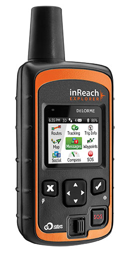
One of the most compelling products in the DeLorme portfolio is its inReach series of two-way satellite communication devices. These GPS-enabled devices allow the user to send and receive satellite text messages or trigger an SOS for emergency help, anywhere in the world. In addition to inReach, DeLorme has an extensive library of digital cartography and enterprise GIS software, as well as traditional mapping.
“DeLorme is a respected brand with exciting products and technologies that are a natural fit in the Garmin portfolio,” said Cliff Pemble, Garmin’s president and CEO. “We look forward to completing the acquisition and welcoming them onto our team. We are looking forward to leveraging their expertise to further enhance the Garmin lineup of products.”
The DeLorme inReach Explorer is a two-way satellite communicator with built-in navigation.
“Our inReach technology is invaluable to hikers, hunters, boaters and pilots who often find themselves in remote areas — Garmin’s core customers. We are looking forward to completing the acquisition and are excited to help leverage our expertise into enhancing their already outstanding products,” said Michael Heffron, CEO of DeLorme. “Garmin has extensive R&D capabilities and a global distribution network that will allow us to provide this technology to customers across many markets and around the world.”
Garmin will retain most of the associates of DeLorme and will continue operations at its existing location in Yarmouth, Maine, following the completion of the acquisition. The Yarmouth facility will operate primarily as a research and development facility and will continue to develop two-way satellite communication devices and technologies. Financial terms of the purchase agreement and acquisition will not be released.
For decades, Garmin has pioneered new GPS navigation and wireless devices and applications that are designed for people who live an active lifestyle. Garmin serves five primary business units, including automotive, aviation, fitness, marine and outdoor recreation.
The City of Sebring, Florida, has deployed TerraGo Edge for utility asset inspection and management. According to a TerraGo press release, using its software has enabled the city to cut costs, bring surveys in-house and improve response times for repairs.
Like thousands of water utilities across the United States, the City of Sebring Utilities Department is tasked with providing a safe and reliable water supply, while managing all the dispersed assets of the water distribution and wastewater systems. To do this, Sebring needs to constantly locate, map and inspect the assets to maintain service levels and operations.
To avoid the high cost of traditional GPS technology and services, Sebring researched mobile products to see if other organizations had field success using iPads and iPhones to do the work. They found TerraGo Edge could deliver custom forms, CAD diagrams and survey-grade accuracy.
“The deployment of TerraGo Edge saved the City of Sebring the expense of a traditional GIS and GPS solution, as well as the cost of surveying services, which could have run over $300,000,” said Mark Kretz, Water Plant Operations. “On a day-to-day basis, the biggest benefit is that we get the ease of use of an iPad, and didn’t have to buy and utilize proprietary GPS handhelds, which are more complex and vastly more expensive.”