Category: Applications

  • FOIF GNSS Receivers Aid with Australian Pipeline Survey

    Photo: FOIF GNSS Receivers

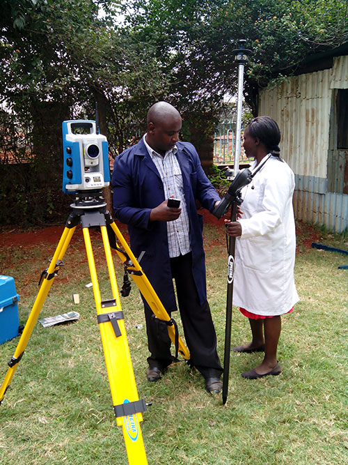
    Three years ago, engineering survey company G & C Sadlier Design was engaged to perform a route selection and centerline pegging survey for a gas pipeline duplication between Somerton in Victoria and Young in New South Wales, Australia. To accomplish the work, G & C Sadlier Design turned to FOIF GNSS receivers.

    So far, about 225 kilometers have been surveyed and constructed, with 306 kilometers still to be surveyed, designed and built, according to surveyor Greg Sadlier. The current focus is a 100-kilometer section in Victoria and a 70-kilometer section in New South Wales. Recently completed are two linear static control surveys over 80 kilometers in Northern Victoria and 70 kilometers at the end of the project near Young in New South Wales.

    Photo: FOIF GNSS Receivers

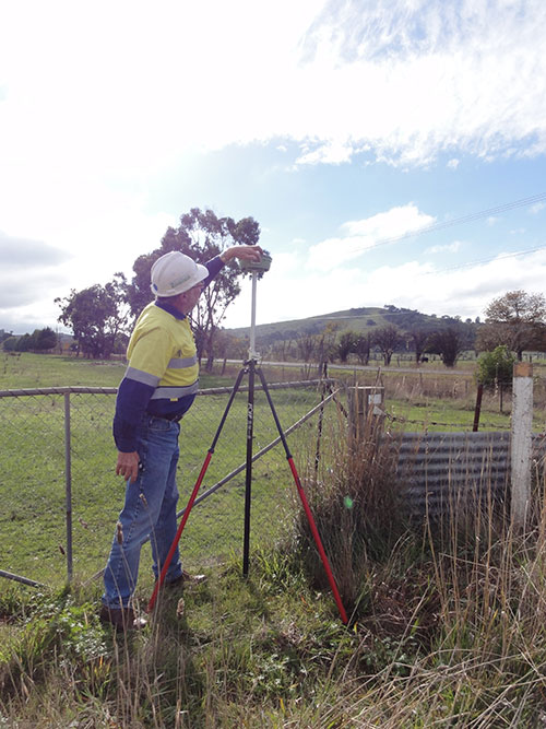
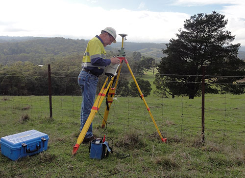
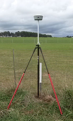
    “These surveys have been done using a FOIF F60 Base GNSS receiver and two FOIF A30 Rover receivers. (Two one-man survey crews are used),” Sadlier said. The procedure is to set up the F60 base over a point with known coordinates and elevation, approximately in the center of the alignment to be surveyed.

    The base was set first, to record 1-second data to the datacard over the duration of the survey. One surveyor started the base, and surveyed forward to the end of the alignment, and the other rover crew started at the beginning of the alignment and surveyed towards the base. The rovers were also set to record 1 second data to the datacard.

    “The control points were 0.75-m steel star pickets driven flush with the ground surface, and witnessed with a galvanized 1.5-m steel star picket,” Sadlier explained. “Each rover point was surveyed for 20 minutes plus 1 minute per kilometer of the distance to the base. That is, a point that is 35 Km from the base will be occupied for 55 minutes or 3300 epochs. With the control points at easy accessed positions, usually roads crossing the alignment, at intervals of about 8 kilometres mean that the survey of 80 Km is completed in one day.

    Photo: FOIF GNSS Receivers “We have found the FOIF GNSS receivers are very easy to use, and the epoch readout on screen is very reassuring that the data is being stored, and easily confirms that the correct amount has been stored. The data is easily downloaded from the card and converted to Rinex format with FOIF RnxTransform. The data was post processed by a third party.”

    The control survey results were adjusted (Helmert adjustment) onto check Permanent Marks at both ends. “This made a rotation of 0°00’00.001” and a shift of 0.007 meters E and 0.005 meter N. An elevation difference of .035 meters was manually adjusted out over the 80 kilometers,” Sadlier said.

    “We are now using the control survey while surveying the route selection and features survey,” Sadlier said. “We have two RTK base locations at the 25-kilometer mark and 52-kilometer marks, and using our VHF radio solution have coverage over the entire job with a 10-kilometer overlap in the center.

    “We have found that RTK observed control readings of 180 epochs return residuals of less than 010 meters for both coordinate and elevation for all the static control points. Very impressive results considering the length of the survey,” Sadlier said.

    The engineering firm has yet to process the New South Wales data, but expects the same or better, Sadlier said, as the overall length is a little less and the surveyed control points were in more open country with less tree cover.


  • Navigation Scientist Reddy Named to Top Position in India

    Navigation Scientist Reddy Named to Top Position in India

    G. Satheesh Reddy
    G. Satheesh Reddy

    G. Satheesh Reddy, a scientist with the Defence Research and Development Organisation (DRDO) of India, has been appointed as the scientific advisor to the defense minister of India, a secretary-level appointment with the government of India. The DRDO is an agency of the Republic of India responsible for the development of technology for use by the military, headquartered in New Delhi.

    Reddy is an expert in navigation technologies. He joined DRDO in 1986 and led the conceptualization, design, development and production of inertial sensors, navigation schemes, algorithms and systems, calibration methodologies, sensor models and simulation, along with development of satellite navigation receivers and hybrid navigation systems. Under his leadership, advanced products and varieties of avionics systems have been produced and successfully flight tested in strategic programs of India.

    As project director, Reddy led the design and development of ring laser gyro-based INS System, MEMS-based INS systems, the sea-guard reference system and the ship navigation system, strengthening the country’s self reliance in high-accuracy and long-range navigation. He also helped develop a 1000-kg class guided bomb.

    Reddy graduated in electronics and communication engineering from JNTU, Anantapur, and received his master of science and doctorate from Jawaharlal Nehru Technological University, Hyderabad. He is a Fellow of Indian National Academy of Engineering (FNAE), the Royal Institute of Navigation London (FRIN), and the Royal Aeronautical Society London (FRAeS). He has been awarded Full Member Diploma and inducted as a Foreign Member of the Academy of Navigation & Motion Control, Russia, and is an Associate Fellow of the American Institute of Aeronautics & Astronautics (AFAIAA) of the United States.

  • Kenya Land Survey Efforts Aided with Spectra Precision Equipment

    Kenya Land Survey Efforts Aided with Spectra Precision Equipment

    Photo: Kenya Department of Surveys The Kenya Department of Surveys has acquired eight Spectra Precision Focus 30 total stations and an additional eight Epoch 50 GNSS receivers as part of an ongoing major effort to adjudicate land and prepare deeds, according to Spectra Precision.

    Until recently, 67 percent of Kenya had yet to be adjudicated even as the work was supposed to be completed within 20 years after it was commissioned in 1957 by the British colonial government, according to the Lands Cabinet Ministry of Kenya. To rectify the problem, the government of President Uhuru Kenyatta two years ago began a major new push to produce three million titles by 2017. So far, the Land Surveys Department reports that 800,000 title deeds had been prepared and are being distributed.

    Oakar Services Ltd., an East Africa geospatial firm, provided the consulting services that led to the Department of Land Survey’s purchase of the Spectra Precision total stations and GNSS receivers.

  • New INRIX Service Helps Drivers Find Parking

    New INRIX Service Helps Drivers Find Parking

    BMW driver interface concept for how INRIX On-Street Parking might be integrated into navigation systems in BMW Connected Drive vehicles. Color coded bars indicate probability of open street parking ranging from green (lots of spaces) to red (not likely to have an open space).
    BMW driver interface concept for how INRIX On-Street Parking might be integrated into navigation systems in BMW Connected Drive vehicles. Color coded bars indicate probability of open street parking ranging from green (lots of spaces) to red (not likely to have an open space).

    Everyone who has ever been frustrated circling the block in search of parking has wished for a solution that could quickly lead them to that elusive spot. INRIX is launching a new service aimed at addressing this problem by helping drivers quickly find on-street parking. BMW will be the first automaker to include the service for its cars, in its ConnectedDrive autos.

    INRIX On-Street Parking answers key questions for drivers including:

    • Where can I park?With availability updated hourly, quickly identify streets with the best chances of finding a parking spot.
    • How much will parking cost? Information on pricing, parking/permit restrictions, policy rules (free vs. paid times/days).
    • Is there a garage or lot nearby? When on-street parking is unavailable, drivers can be directed to one of more than 80,000 off-street parking locations in Europe and North America. The service provides pricing and availability information, ability to compare locations by distance and price as well as locate the nearest entrance.

    BMW and INRIX demonstrated INRIX On-Street Parking in a BMW i3 at the Telematics Automotive 2015 conference, showing how location, local rules and pricing, real-time traffic, transactions and mobile data can be analyzed through the INRIX platform to show which streets have available parking.

    “As we continue to connect cars to smarter cities, INRIX On-Street Parking fills a critical gap that addresses the growing challenge of traffic and parking in our cities worldwide,” said Bryan Mistele, President and CEO, INRIX.  “And looking ahead to a time when autonomous cars are a reality, this service enables vehicles that drive themselves to park themselves now as well.”

    Visualization showing INRIX On-Street parking occupancy by block for key neighborhoods in downtown San Francisco. Color coded bars indicate probability of open street parking ranging from green (lots of spaces) to red (not likely to have an open space).
    Visualization showing INRIX On-Street parking occupancy by block for key neighborhoods in downtown San Francisco. Color coded bars indicate probability of open street parking ranging from green (lots of spaces) to red (not likely to have an open space).

    Initially available in Seattle; Vancouver, B.C.; San Francisco; Amsterdam; Cologne and Copenhagen, the service will expand to cover 23 cities by the end of the year.

    Experts estimate up to 30 percent of traffic in congested urban areas where street parking is in high demand results from drivers  looking for parking. A global survey of commuters in 20 international cities found that nearly 6 out of 10 drivers have abandoned their search for a parking space at least once, and drivers often spend an average of nearly 20 minutes in pursuit of a coveted spot. Further, an analysis by Frost & Sullivan found that drivers waste an average of 55 hours per year searching for parking, costing consumers and local economies nearly $600 million in wasted time and fuel.

    Smarter Parking Information

    With more than half of the world’s population living in our largest cities, transportation agencies are increasingly turning to intelligent parking solutions to better manage parking inventory and improve urban mobility. INRIX On-Street Parking provides cities with a scalable, cost-effective and immediate way to manage parking inventory as well as improve traffic in urban areas, INRIX said.

    On-Street Parking to cities includes:

    • Real-time Information. Goes beyond one-time snapshots of parking availability, allowing cities to see how parking inventory changes based on time of day, day of week, price and during special events or holidays.
    • Less reliance on road-side counters and costly sensorsOffers a faster, more cost-effective way for cities to manage parking. The service goes beyond current smart parking technologies because it also works on roads without smart meters or sensors and outside of hours requiring payment.
    • Better insight for urban planning. With a comprehensive understanding of parking inventory usage citywide, urban planners can gain insights that help them improve parking conditions and locations, and better locate special purpose lanes for bicycles and public transit on city streets.
    • Calibrate demand pricing models. Provides insight into how pricing fluctuations impact demand in real-time. Cities can optimize pricing to maximize use of available inventory citywide.

    Automakers, mobile app providers and public sector agencies interested in learning more can register for a Webinar scheduled for June 17 at 8 a.m. EDT where INRIX will outline use cases, technical specifications and benefits in greater detail.

  • Affordable Wearables Strong in First Quarter before Apple Watch Debut

    The worldwide wearable device market recorded its eighth consecutive quarter of steady growth in the first quarter of 2015. According to the International Data Corporation (IDC) Worldwide Quarterly Wearable Device Tracker, vendors shipped a total of 11.4 million wearables in the first quarter, a 200 percent increase from the 3.8 million wearables shipped in the first quarter of 2014.

    “Bucking the post-holiday decline normally associated with the first quarter is a strong sign for the wearables market,” said Ramon Llamas, research manager, Wearables. “It demonstrates growing end-user interest and the vendors’ ability to deliver a diversity of devices and experiences. In addition, demand from emerging markets is on the rise and vendors are eager to meet these new opportunities.

    “What remains to be seen is how Apple’s arrival will change the landscape,” added Llamas. “The Apple Watch will likely become the device that other wearables will be measured against, fairly or not. This will force the competition to up their game in order to stay on the leading edge of the market.” The Apple Watch began shipping April 24.

    “As with any young market, price erosion has been quite drastic,” said Jitesh Ubrani, senior research analyst, Worldwide Mobile Device Trackers. “We now see over 40% of the devices priced under $100, and that’s one reason why the top 5 vendors have been able to grow their dominance from two thirds of the market in the first quarter of last year to three quarters this quarter. Despite this price erosion, Apple’s entrance with a product priced at the high end of the spectrum will test consumers’ willingness to pay a premium for a brand or product that is the center of attention.”

    Wearable Vendor Highlights

    Fitbit started 2015 the same way it ended 2014: as the clear market leader in the worldwide wearable device market. Fitbit’s first quarter shipments were driven by the release of three new devices (the Charge, Charge HR, and the Surge) along with continued demand for its older Flex wristband and One and Zip clip-on models. Separately, these address multiple segments of the market, from casual exerciser to committed athlete, and collectively leverage Fitbit’s behavior change engine to encourage activity.

    Xiaomi started off the year by blasting through the one million unit mark with its Mi Band for the first time, a significant feat made all the more impressive considering the device just started shipping during the second half of 2014. Similar to its smartphones, Xiaomi’s Mi Band was delivered primarily within its home country of China, but recent announcements point to more global aspirations for the company.

    Garmin’s wearable device portfolio spans multiple areas of health and fitness, including activity tracking, running, hiking, golfing, triathlons, and multi-sport. The majority of Garmin’s devices are GPS-enabled to track location and distance, and some leverage the company’s ConnectIQ third-party applications to record activity, show notifications, and news.

    Samsung’s fourth place finish came from worldwide demand for its Gear smartwatches. Since its debut in 2013, the Gear portfolio has diversified to include the Tizen-powered Gear, Gear 2, Gear Fit, Gear 2 Neo, Gear S, and the Android-Wear powered Gear Live. What has limited Samsung, however, is the ability for Gear devices to connect only with select high-end Samsung smartphones.

    Jawbone beat Pebble and Sony for fifth place, a result driven by the release of its UP MOVE and continued demand for its nearly year-old UP24. The company will release two new devices in the second quarter of 2015, with the similarly-functioning UP2 and the mobile payments-enabled UP3. The company maintained its design strategy of no displays, but again touted its predictive data engine to encourage healthier lifestyles.

    Top Five Wearables Vendors, Shipments, Market Share and Year-Over-Year Growth, Q1 2015 Data
    (Units in Millions)
    Vendor

    1Q15 Shipment Volumes

    1Q15 Market Share

    1Q14 Shipment Volumes

    1Q14 Market Share

    Year-over-year Change

    1. Fitbit

    3.9

    34.2%

    1.7

    44.7%

    129.4%

    2. Xiaomi

    2.8

    24.6%

    0

    0.0%

    N/A

    3. Garmin

    0.7

    6.1%

    0.3

    7.9%

    133.3%

    4. Samsung

    0.6

    5.3%

    0.3

    7.9%

    100.0%

    5. Jawbone

    0.5

    4.4%

    0.2

    5.3%

    150.0%

    Others

    2.9

    25.4%

    1.3

    34.2%

    123.1%

    Total

    11.4

    100.0%

    3.8

    100.0%

    200.0%

    Source: IDC Worldwide Quarterly Wearable Tracker, June 2, 2015

    Table Notes:
    • Data is subject to change.
    • Vendor shipments are branded device shipments and exclude OEM sales for all vendors.
    • The “Vendor” represents the current parent company (or holding company) for all brands owned and operated as subsidiary.
  • TomTom Offers Test Map Data for Automated Driving

    TomTom is making available Highly Automated Driving (HAD) map content in the metro Detroit area, where U.S. automakers are headquartered. Car makers and HAD-related companies can now use TomTom’s high-definition maps for precise vehicle positioning, enabling future self-driving cars to see beyond their sensors.

    The HAD map, covering the stretch of road network between Farmington Hills and Ann Arbor, including I-696, 96, and 275, US-23 and M-14, will be available in June. TomTom discussed the HAD map in a session at TU-Automotive Detroit trade show, held June 3-4.

    “By making high-definition map content readily available, we can make HAD a reality faster, enabling further innovation in Detroit, the heart of the North American automotive industry,” said Alain De Taeye, member of the TomTom Management Board. “Intense demand for high-definition maps is fueled by automated driving as a new growth driver. As an independent supplier with one of the world’s most sophisticated mapping platform, we are in a unique position to provide highly precise map content for all members of the HAD ecosystem.”

    For the Consumer Electronics Show (CES) 2015 in January, the Audi A7 piloted driving concept car dubbed Jack used TomTom HAD prototype maps to complete a long-distance test drive, over 560 miles from San Francisco to Las Vegas.

  • Magellan Launches Off-Road Nav Platform for Auto OEMs

    Magellan has launched an Off Road Vehicle (ORV) Navigation platform for automotive OEMs and power sport vehicle OEMs. The new platform was showcased at the TU-Automotive Detroit trade show, held June 3-4.

    Designed specifically for the off-roading enthusiast, the Magellan ORV Navigation platform allows off-road enthusiasts to plan, track and save trail rides and dirt miles, and add pictures and comments to trails.

    The Magellan ORV platform includes an online user community, where riders can plan and save their trails, share trails with other riders, add pictures and comments to trails, and search for new trails. In addition, the Magellan ORV platform includes the most comprehensive outdoor trail maps available for off-road enthusiasts, covering all 50 states and Canada.

    Trail Maps

    The Magellan ORV platform’s trail maps are cloud based, dynamic and will continue to grow and be improved by both Magellan and the user community. Magellan’s detailed ORV maps include:

    • 3D Terrain & contour elevation lines
    • National, State & Provincial service roads and trails
    • National, State & Provincial Parks and Recreational Vehicle Areas
    • Scenic Byways
    • Crowd-sourced trails
    • Food, Gas, Lodging, and General Service POI
    • 3rd Party Trail Guides

    Online User Community

    Off-road enthusiasts have exciting stories to save and share. The Magellan ORV navigation platform gives off-roaders, campers, and anyone enjoying the outdoors on a vehicle the tools to plan, experience, and capture their activities in a story format, that they can keep or share with friends, family, or the larger off-road and outdoor communities.

    Users can add comments and pictures to their trail rides, and share with other members of the Magellan ORV community. Magellan ORV community users can also share posts and pictures to Facebook, Twitter and Instagram directly from the Magellan ORV app.

    As users share their trail rides, they garner community ranking and earn achievement badges.

    iOS and Android Companion Smartphone Apps

    To be a resource for the entire off-road community, Magellan’s standard iOS and Android ORV apps will be available in the iTunes and Google Play stores. This will enable any off-road enthusiast to find trails and record, save and share their own adventures.

    “The Magellan ORV navigation software is designed and targeted specifically to reach off-road and outdoor enthusiasts,” said Stig Pedersen, associate vice president of product management for Magellan. “It allows customers to use their technology to participate in and share their trail and outdoor experiences. It reflects the interests of technology savvy off-road enthusiasts, and makes off-roading achievable for aspiring off-road enthusiasts.”

    Designed for Auto OEMs

    Magellan’s smartphone driven ORV navigation platform is compatible with all major infotainment platforms, including Weblink, CarPlay and Android Auto. The ORV platform can be branded by automotive OEMs so their customers have a consistent brand experience while planning a trail ride, and in the vehicle.

    “Given the tremendous popularity of 4×4 SUVs in the US, and other major regions, Magellan’s ORV solution is a tremendous opportunity for auto OEMs to provide their customers with an integrated off-road solution that takes advantage of today’s in-dash and smartphone technology,” said Peggy Fong, president of MiTAC Digital Corporation, parent company of the Magellan brand. “With the new Magellan ORV navigation platform, auto OEMs can add to the fun and excitement enjoyed by both off-road enthusiasts and other outdoorsmen, such as hunters, fishermen, and campers.”

  • Google Car Drives Itself for One Million Miles

    Google Car Drives Itself for One Million Miles

    google_car_prototype_december_2014-780x5191
    The 1-million-mile milestone was for modified Lexus RX 450h SUVs equipped with the self-driving technology, but the car pictured here — built entirely by google — is more fun to look at. (Image: Google)

    Google’s self-driving car has driven itself one million miles. Google announced the milestone June 4 on Google Plus. “Our software has now self-driven the equivalent of 75 years of typical U.S. adult driving! Along the way, we’ve navigated more than 200,000 stop signs, 600,000 traffic lights, and seen 180 million vehicles — with several thousand traffic cones, some fluttering plastic shopping bags, and a rogue duck thrown in for good measure.”

    In May, Google announced that the car had driven 1.7 million miles, but that number was for both autonomous and manual driving, The one-million-mile milestone the car just reached is for autonomous driving only.

    “We’ve come a long way since +Larry Page [Google president and CEO] first challenged us to demonstrate that self-driving technology had long-term potential. Back in 2009, he gave us two audacious goals. The first was to drive 100,000 miles on public roads; in 2009, this was about 10x more miles than had ever been completed by any autonomous driving team. The second was to drive 10 sets of 100 interesting miles — well-known California routes that included crossing the Golden Gate Bridge, navigating the curves of Lombard Street in San Francisco, and traversing the 200+ traffic lights of major boulevard El Camino Real.

    “We met those early goals, but it was hard to imagine we’d ever cruise the boulevards of Mountain View, Calif., as smoothly as we do today. We’re taking this million mile milestone as further proof that fully self-driving vehicles will become a reality, and we’re looking forward to finding out where the next million miles will take us.”


  • Geospatial a Surprising Highlight of eMerge Trade Show

    Two weeks ago I helped a colleague with a trade show in Miami called eMerge Americas. This was a general-interest trade show focused on U.S. and Latin American trade and economic development. It wasn’t GEOINT or an ESRI users conference, so I didn’t expect any significant geospatial exhibitors, but I was wrong.

    In fact, there were so many geospatial-related displays, I decided to build my column around it — not because there were new developments, but to give you a feel for how business in general is being exposed to and shaped by our geospatial technology.

    I found so much visual content that under the “picture is worth a thousand words” philosophy, I shot video clips of exhibitors so that you could quickly hear and see their stories. I discovered a number of true start-up businesses, as well as a large area devoted to showing robotics from local school programs. You may not have the time to view each clip, so the following are brief descriptions of each exhibitor that caught my attention:

    Introduction to eMerge Americas

    Esri. Because Latin America is a large and growing market, Jack Dangermond had his team there.

    Indra. A large Spanish firm demonstrating their end to end solutions including building 3D models overlaid on Google.

    Cisco. Cisco had a very large display showing city management of transportation/utilities/ planning using geospatial tools and management systems.

    Fish. A company that tracks people and assets using RFID tags and indoor location technology.

    Florida International University. FIU had numerous technology displays but their autonomous catamaran doing bathymetry data collection and mapping was impressive.

    CartoData. This was a Mexican firm doing some very impressive end-to-end solutions including the use of Pix4D to build 3D models from UAV data.

    ImPlaces. A small start-up that builds Smartphone GPS location enabled applications for self guided tours such as museums, parks, real estate, etc.

    Baptist Health. Baptist Health demonstrated its 3D remote surgery system that was dimensionally scalable. These systems permit a surgeon to work at a macro level while the surgical tools operate a at microscopic level.

    ICONICS. A company that can zoom from a country or regional map down to the detail of an individual valve in a specific plant using CAD/BIM data.

    RangeVideo. A UAV company with a very flexible platform and 3D operator viewing goggles.

    ALTA Systems. An alternative to powered UAVs.

    SnowLizard Products. A small start up building durable waterproof Smartphone cases with Bad Elf GPS and solar panel recharging.

    Catbird. A data system security oversight system.

    VSN 360. There was a lot of interest in this product. VSN was showing a new 4K HD quality 360-degree video camera a little bigger than a coffee mug with many features. My video of a video didn’t do it justice, so here is a link to the demo video.

    For fun, view these non-geospatial exhibitors:

    Holography Box USA. A portable, rear projection, point-of-sale video display that looks like a 3D hologram.

    TeamSandTastic. A company that provides sand sculptors for trade shows or other events. Doesn’t sound exciting, but just like a Zamboni clearing the ice, you can’t stop watching as an artist turns a pile of sand into a sculpture.

    Robotics. Local students show off their robotic construction efforts and operational talents.

    Because eMerge has been so well received, I’m happy to see plans are in place to make this an annual event. Latin America is a large and growing market with many talented individuals, some of whom I met at this conference. As a country, we seem to take Latin America for granted, but this a region that shares our values. We need to nurture our relationships and work to prevent the kind of attitudes found in areas hostile to American values.

  • GPS ‘Unreliable Event’ Scheduled for Friday at Holloman AFB

    The 746th Test Squadron will perform a Global Positioning System unreliable event, scheduled at Holloman Air Force Base, June 5, 12:30 p.m. to 4:30 p.m. A GPS unreliable event is an interruption to all GPS signals. The interruption will affect any and all electronic devices in the area that use GPS, such as cell phones, running devices, laptops, computers, tablets, cars with navigation and a number of other electric devices. 

    Details are available here.

    This information is from an announcement posted on the White Sands Missile Range Public Affairs Facebook page. It is unknown whether this test is related to the U.S. Air Force’s new “gold standard” Truth Reference System, based on Locata technology, which is reportedly now operational at the White Sands Missile Range, although no official announcement has been made.

    https://www.facebook.com/WSMRPublicAffairs/posts/10153091494058052

  • Surveyors Invited to ‘Survey Earth in a Day’ — in 4D

    Survey-Earth-in-DayOn the day of the solstice, June 21, geospatial professionals around the world and members of Land Surveyors United (a global support network for land surveyors) will be simultaneously recording survey-grade GPS data from thousands of points around the globe, to gain a more accurate understanding of the earth’s surface.

    Measurements made on Survey Earth in a Day 4D (SEIAD) will serve as comparative data from prior events and to expand upon the database of logged points. “This year it will be called 4D, as we will be layering the data from our previous three years into a single map, representing points data gathered from thousands of locations around the planet by professional surveyors,” organizers said. “This day is the largest geospatial event in history as it allows surveyors to participate in their own location. With close to 3,000 more members than we had last year, we are hoping that all of you will participate from your location on June 21.”

    In 2012 the first Survey Earth event was held, establishing many new understandings between geospatial and geomatics professionals and the general public on geospatial issues, organizers said. “With a mission not only to learn more about the Earth’s surface but also monitor its changes over time, and the changes in public perspective, as a global community, we may be more capable of assessing our future,” organizers said.

    Also, International Surveyors Week 2015 occurs during the week, which ends with SEIAD. Visit the event website to sign up and learn how to participate, or follow SEIAD on Facebook.

  • INTERGEO Conference in Stuttgart Focuses on Future

    InterGeo-logo

    The conference program and registration for INTERGEO 2015 are now live. Register before July 31 to benefit from the early-bird booking rate.

    The conference will open with keynote speeches by Chris Cappelli (Esri Inc.) on “The Age of the Location Platform: How Mapping and GIS are Transforming the Work Environment” and Prof. Georg Gartner (TU Wien, Vienna University of Applied Sciences), president of the International Cartographic Association, on “The Future of the Map – the Map of the Future.” 

    “The agenda for the INTERGEO conference in Stuttgart is packed with exciting topics that are the focus of ongoing political debate on the digital world and will play a key role in shaping the way we work in future,” reads a statement by INTERGEO. “With keynote speeches and plenary talks delivered in English and simultaneous interpreting provided for one strand of the conference on the second day, it is clear that INTERGEO is also becoming increasingly significant on an international scale.” 

    The major topic of discussion at 2014’s INTERGEO remains a key part of the conference this year — INSPIRE examines geo-issues from a European perspective, providing practical examples and focusing on further development of the European directive. Other central themes include geodata as a basis for construction management and land development, a major concern for future development at regional and local level, as well as issues relating to property markets and valuation. These subjects are all crucial when it comes to discussing the “smart cities” and “smart villages” of the future, according to INTERGEO.

    Another highlight of INTERGEO in Stuttgart this year will be the panel discussion on the second day on “Geospatial Information – A Key Element for Emerging Markets.” The high-profile panel of speakers include Bengt Kjellson (UN-GGIM Europe), Ola Rollen (Hexagon), Steve Berglund (Trimble) and Chris Cappelli (Esri Inc.).

    A further key topic at the conference that is set to have a profound effect on the working world is geoinformation and mobility. DDGI and DVW will be addressing this together and discussing practical examples in two event strands.

    The contributions on big data will focus on the rapid development of data capture, processing and presentation as well as the direct integration of data into business processes. Geoinformation as an element of networked processes is a subject of major international significance, as evidenced by the conference’s high-profile speakers. “In terms of digitization, the conference will be key to paving the path to Geospatial 4.0 and the networking of digital geodata,” said Prof. Karl-Friedrich Thöne, president of the event’s host, DVW, adding, “INTERGEO is the ideal forum for creating processes that could eventually benefit the entire value-added chain.”

    As important as data may be in the digital world, it is also crucial to have the right visualization concepts in place. This will be demonstrated through presentations on the German Cartographers’ Day, which will form part of INTERGEO this year.