Trimble announced today a new version of its CenterPoint RTX correction service that delivers convergence to 4-centimeter horizontal accuracy in less than 5 minutes. The service is designed for a variety of precision agriculture operations in Central and Western Europe, and is available for use with the Trimble CFX-750 display.
Trimble CenterPoint RTX delivers highly accurate GNSS corrections via satellite without the need for traditional reference station RTK infrastructure, mobile data plans or additional on-machine hardware. The GNSS-enabled correction service delivers repeatable, real-time high-accuracy positions for land preparation, planting, harvesting and other high-precision farming applications.
Enabled by the new version of RTX technology, RTX version 5.0, the fast convergence time is the result of a new region-specific atmospheric model and a dense ground reference station network. Growers will realize an approximate 80 percent improvement in RTX convergence time as compared to the RTX-standard service that typically provides 30-minute convergence time, Trimble said.
Delivered via a new satellite broadcast covering western and central Europe, the new service will be available in Austria, Belgium, Czech Republic, France,Ireland, Germany, Luxembourg, the Netherlands, Western Poland, Southern Sweden and the United Kingdom.
“We are continually advancing our Trimble RTX technology to improve productivity in the field,” said Patricia Boothe, general manager of Trimble Positioning Services. “Faster initialization times allow growers to start working more quickly, freeing up time to focus on other farm operations. No other satellite-delivered correction service today can offer better than 4 centimeter accuracy in less than 5 minutes.”
NovAtel has announced significant performance improvements to its precise point positioning (PPP) solution. NovAtel CORRECT with PPP will now offer the new TerraStar-C correction service as its exclusive source for satellite-delivered PPP correction data.
TerraStar-C contains an enhanced correction data set that enables up to 4-centimeter accuracy and instant re-convergence when combined with the receiver error models and positioning algorithms offered by NovAtel CORRECT. This new level of PPP performance is available on NovAtel’s OEM6 receivers with firmware version 6.600.
NovAtel CORRECT is the positioning algorithm on NovAtel’s GNSS receivers that handles corrections from a variety of sources, including real-time kinematic (RTK), PPP, spaced-based augmentation systems (SBAS) and differential GPS (DGPS). NovAtel CORRECT with PPP combines GNSS satellite clock and orbit correction data from TerraStar’s global reference station network with NovAtel’s receiver algorithms to yield robust sub-decimeter positioning without the need for nearby base stations.
Correction data provided by TerraStar is delivered to the end user via Inmarsat satellites. With satellites visible globally, PPP is an ideal solution for precision applications where communications infrastructure is either unreliable or not available. In addition, applications where signal interruptions are common will benefit from a more robust positioning solution with the ability to quickly regain full accuracy following a temporary loss of GNSS signals, NovAtel said.
NovAtel customers with current TerraStar-D subscriptions have the option to upgrade to the new TerraStar-C service level free of charge. The new NovAtel PPP performance level is available immediately.
Tallysman Wireless has released a hosted data service for its TruFleet AVL (Automatic Vehicle Location) system, which runs on MOTOTRBO digital two-way radio networks. The new service enables Tallysman’s channel partners to build and brand their own carrier network of individual radio systems and to generate an ongoing revenue stream using any MOTOTRBO radio configuration, from conventional repeaters though to wide area trunking systems.
TruFleet is a web browser interface for Tallysman’s fleet management AVL application that enables clear fleet overview and management. It delivers excellent web-based reporting capabilities, is very reliable, and has a rich, intuitive interface that is simple to master and to operate.
The new TruFleet hosted data service enables channel partners to offer a cost-effective AVL solution for fleet sizes with as few as 15 subscribers.
“The TruFleet solution generates compressed batched messages transmitted at a low reporting rate, similar to first generation Tallysman Sprite devices, but a patent-pending algorithm provides much greater data compression, conserving data bandwidth,” said John Seymour, director of data systems at Tallysman. “This enables us to to provide precise positioning at rates that are competitive with cellular systems.”
1Spatial plc, a spatial big data company, was acknowledged for the second year running in the London Stock Exchange’s (LSE) research report as one of “1000 Companies to Inspire Britain.”
1Spatial provides the software and services to manage spatial big data, working with users and creators of geospatial databases to help them collect, manage, plan, maintain, publish and interpret location-specific information. Its clients include national mapping agencies, land registries, utility and telecommunications companies, and government departments including emergency services, defense and census bureaus.
To be considered for inclusion in the report, companies had to meet a range of criteria. These included being UK based, having a turnover of between £6-250 million in the last 12 months, and having a minimum of three years in operation. Companies had to demonstrate not only a positive growth in revenue over the last four years, but also an increase in employee numbers, workspace, contract wins or patent filings.
The LSE research report examined in detail the opportunities and challenges facing small and medium-sized enterprises and looked at the sectors and trends that will shape the future of the UK economy.
Veripos, a supplier of high-precision GNSS positioning facilities to offshore and associated industries, has upgraded its Apex and Apex² precise point positioning (PPP) services.
The services now typically provide users with a horizontal position accuracy of better than 5 cm and 12 cm in the vertical at the two sigma (95 percent) confidence level.
The enhanced levels of performance, now available to all current users of Apex and Apex² without any need to upgrade, have been calculated from static data obtained in Aberdeen, Scotland, where Veripos is headquartered, as well as Houston, Texas, and Singapore. Veripos said that accuracies may vary with observing conditions, however.
The improved accuracy follows a major upgrade of the entire Veripos global reference station network for tracking all GNSS signals, together with introduction of new receivers and geodetic antennas for delivery of better measurement quality resulting from refinements to algorithms and software used to derive necessary GNSS orbit and clock corrections.
Designed to meet all offshore positioning and navigation applications, the dual-beam Apex and Apex² PPP services are relayed via seven geostationary communications satellites to ensure continuous availability and service redundancy while providing access to both GPS and GLONASS constellations. Positional accuracy is maintained regardless of user location, Veripos said.
Connor-Winfield is offering two new temperature compensated crystal oscillator models. TL602 and ML602 TCXO models are designed for use in conjunction with 0.1-Hz (and higher ) filter bandwidths for compliance with T1-based hierarchy specifications such as ITU-T G.8262 Option 1 and 2 ECC and ITU-T G.813 Option 1 and 2 SEC, Stratum 3 for Sonet, IEEE1588 and Synchronous Ethernet. CW’s TCXO line utilizes analog temperature compensation for excellent short-term stability characteristics, the company said.
The TL602 and ML602 TCXOs maintain 280-ppb pk-pk frequency stability over the industrial temperature range of -40 to +85C. They are also excellent frequency reference choices for small cell, wireless and instrumentation applications, Connor-Winfield said.
Features:
Available frequencies are 10 MHz, 12.8 MHz, 19.2 MHz, 19.44 MHz, 20 MHz and 24.576 MHz.
LVCMOS or clipped sine.
Fixed output or Voltage control.
Meets MTIE and TDEV masks measured at 0.1-Hz bandwidth.
Short term stability 1×10⁻¹⁰ performance.
280-ppb peak-to-peak temperature stability over the full industrial temperature range.
Sub-300 ps jitter performance over 12 kHz-20 MHz band.
Lifetime accuracy of +/- 4.6 ppm.
Full ROHS and REACH compliance.
7×5 mm (TL602) or 5×3.2 mm (ML602) packaging options.
Editor’s Note: Don Jewell, GPS World’s Defense PNT newsletter editor, served 30 years in the United States Air Force as an aviator and a space subject-matter expert. The views expressed are his own.
It was a dark and stormy night, followed by an even more challenging predawn in the far North. Clouds and blowing snow mixed with stinging ice crystals scudded over the ocean and the hills of southwest Iceland. I knew from personal experience that the crew inside the Airborne Warning and Control Aircraft (AWAC) E3, especially the cockpit crew, were watching the weather closely as they listened to tiny ice pellets pinging off the aircraft. The winds gusted at 20-30 knots from the east, and the Keflavik tower was in the midst of turning the airport around, which meant that all aircraft would depart to the east over land, versus the normal departure SID (Standard Instrument Departure) to the west over water.
(I must interrupt my tale briefly to tell you that GPS plays no role in the 1978 drama that is about to unfold. At its conclusion, I will describe the differences GPS has made in the operation of strategic military aircraft, and why a recent book is one of the best arguments for GPS/PNT systems I have ever read.)
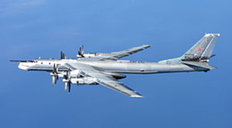
I was stationed as a permanent party USAF officer in Iceland assigned to Detachment One of the 552d Airborne Warning and Control Wing which flew the latest AWACs out of Iceland to help defend the GI-UK (Greenland, Iceland, United Kingdom) gap. Russian TU-95 four-engine turbo-prop Bear bombers flew non-stop over the GI-UK gap, at jet speeds (550-575 mph) from Murmansk in what was then the Soviet Union, on a regular basis, en route to visually and electronically surveilling and reconnoitering — spying on — the East Coast of the United States, and then landing in communist-controlled Cuba.
Russian TU-95 “Bear” Bomber (courtesy of Wikipedia and RAF).
That memorable morning just before Christmas in 1978, I was the Supervisor of Flying (SOF) for all USAF military aircraft at Keflavik AB, which was both an Icelandic commercial airport and U.S. military installation. As SOF, I double-checked all the flight information for the AWACS aircraft, visually checked that the aircraft were ready for take off and flight, and surveyed the airport and runway environment to make sure there were no hazards to the aircraft or crew. Because the weather was rapidly deteriorating that morning, I also checked all the alternates for the AWACS in England and Scotland.
Supervisor of Flying (SOF)
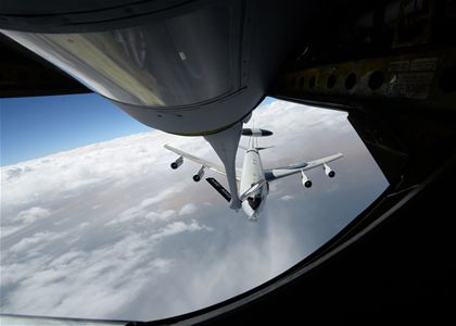
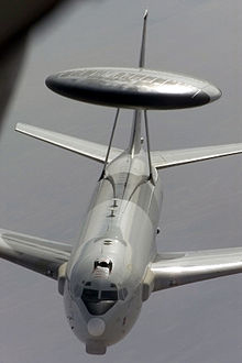
AWACS (Photo courtesy of the USAF).
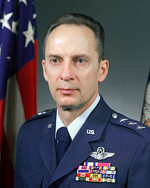
I was comfortable in my Command Vehicle, a new British Range Rover, vintage 1978, equipped with a plethora of radios that connected me to everyone on the airfield, including the control tower and the U.S. military Command Post. Externally, the vehicle had a constantly flashing yellow light so that I could be easily seen and identified by the tower and the aircraft I inspected. There were external blue and red lights and sirens, which came into play when we launched the alert E3 aircraft or there was an emergency. All in all it was a very comfortable and functional mobile airfield office. But this morning I had a welcome addition. My boss, Major General-selectee John L. (Pete) Piotrowski, the 552nd Wing Commander, had stopped by on his way from Japan, en route the long way home to the AWACS base, Tinker AFB in Oklahoma.
For many officers (I was just a major at the time), having your General Officer boss onboard might have been intimidating, but not for me. General Piotrowski was a valued mentor and friend as well as a true gentleman and professional USAF officer of the highest caliber, and frankly, I welcomed his presence and experience. I was happy he had come to personally check out the very first AWACS detachment. Little did I know how pivotal his presence would be that cold, dark and blustery Icelandic morning.
There were two full crews aboard the AWACS aircraft I had just checked and cleared for departure, a senior crew in the cockpit and two mission crews that would get some much needed training on the way back to Tinker, so they would not go “non-current” over the Christmas holidays. Crews typically deployed to Iceland from Tinker AFB for a 10-day tour and then rotated back to CONUS and then to other disparate operation locations around the globe.
(Courtesy of the USAF).
Weather and planning-wise, Iceland was the most challenging for the E3 aircrews because of the annual snowfall of 311 inches and the siren call of suitable and weather-wise more hospitable alternates, with proper facilities and security arrangements, which were more than a hour away in England and Scotland, so planning was key. However, that morning all the crew was thinking about was getting home and enjoying the holidays (we called it “gethomeitis”) and, unfortunately, it played a key role in that mornings near catastrophe. I, of course, wanted to impress my boss with my thoroughness and professionalism, so I was double- and triple-checking every little detail.
Remember, 1978 was the same year the first fully operational, non-test, GPS satellite was launched into MEO orbit, so there were no GPS receivers on the AWACS aircraft. Instead, at that time the prevailing technology called for precisely surveyed aircraft parking spots on the ramp. The coordinates of these spots were typically entered into the E3’s INSs (inertial navigation systems) before they taxied for takeoff. Because the departing AWACs were nominally always parked in the same spots near the prevailing runway for a quick reaction or alert takeoff, the procedure quickly became routine for the AWACs flight crews. This routine also contributed to the nearly catastrophic incident that blustery and memorable morning.
Even with the deteriorating weather and the gusty winds, there appeared to be no reason why the E3 should not depart on schedule. Then, just five minutes before scheduled take off, the wind shifted dramatically and suddenly to an easterly direction. The tower immediately “turned the airfield around” and cleared the E3 for a takeoff to the east – the only problem was the aircraft was already lined up on the prevailing runway ready for a routine westerly departure. So the Icelandic controllers in the Keflavik tower promptly cleared the E3 for a rapid taxi down the active runway, so they could turn around (180 degrees) on the other end and still make an on-time takeoff. This was actually rather a common occurrence for those of us who were permanent party, so no one was concerned.
The E3 Aircraft Commander (AC) was a senior 06 — an USAF full Colonel. (Note: The subsequent safety investigation proved the AC’s rank and seniority, plus the crew’s reluctance to question his decisions, were a contributing factor in the incident.) The colonel responded to the tower, “Roger, understand, cleared for takeoff” and the aircraft began to roll down the runway in what General Pete, the tower personnel and I all initially assumed would be a fast taxi to the other end of the runway. At the time, I remember thinking, “I wonder why he did not respond correctly with the complete clearance, which was to taxi to the other end of the runway and then be cleared for takeoff to the East?” However, since it was 0500 and no other aircraft were in the area, no one was too concerned — until we saw that the E3 aircraft was continuing to accelerate to the point that the spray caused by the tires and the blowing snow thrown up by the four big jet engines nearly obliterated the aircraft from our vantage point.
General Piotrowski (Photo Courtesy of the USAF).
I think General Pete and I realized at the same moment that the EA was making a dangerous downwind departure. However, we realized it too late, as did the tower. General Pete and I simultaneously reached for the radio microphone, connecting us to the departing E3 aircraft at the same moment, but then neither of us made the radio call to the aircraft because we realized the pilot in command would have his hands full. At this point, the aircraft was going much too fast to stop on the wet and icy runway available, plus the AC did not need the distraction of a radio call in the middle of what was rapidly becoming a possible emergency situation. I do vaguely remember turning on my red and blue lights and my siren and accelerating down the active runway, in pursuit of the E3, and making the radio call “SOF on the Active” to the tower, as I wanted to be as close to the aircraft as possible if it stopped with hot brakes, or crashed into the barrier or the water. E3 (707 320B) aircraft are notoriously susceptible to control and start issues with tailwinds, and I must admit that I did not think for a moment the aircraft stood a chance of actually getting airborne. Miraculously, the E3 managed to lift off in the overrun at the far end of the runway and grudgingly managed what appeared to be about a five to ten feet per minute positive climb rate out over the water, before it rapidly disappeared into the lowering cloud deck.
General Pete and I sat there in shock and disbelief for a full five minutes before we heard the tower give the aircraft a new departure heading and frequency. We waited to be sure the aircraft replied, and since no emergency was declared, we knew they were finally safely on their way home.
Needless to say, incident and safety reports were filed, audiotapes from the tower were copied and forwarded to the 552nd Wing Safety Office, and I filed my SOF report. Normally, I would have called the 552d Wing Commander as well, but of course he was seated right there beside me. Long story short, the rest of the flight went without a hitch, and the crew landed safely at Tinker AFB 14 hours later after a successful mission that included two aerial refuelings. The flight crew was immediately suspended pending an investigation and the aircraft was impounded and inspected.
AWACS refueling (Photo courtesy of the USAF).
Two months later, I attended the safety inquiry at Tinker AFB into the incident in question. At the time of the incident, only the Keflavik tower, General Pete, myself and the cockpit crew knew what had happened. The 20+ mission crew members had no idea their lives had been in peril. There were reportedly comments among the mission crew about an extremely long takeoff run, but beyond that, there were no crew concerns.
During the hearing, the AC admitted that once he realized his mistake and calculated he could not stop the aircraft on the wet and slippery runway, he asked for full military power (military-rated thrust) on all four engines, which means the throttles were pushed to the stops and every ounce of power the engines had was engaged. It was a matter of life and death, and yet at the inquiry, when General Piotrowski fired most of the flight crew and told them to find jobs elsewhere, there were no raised voices or angry words, no shouting or swearing. General Piotrowski handled it like the true gentlemen he still is today. Later that same day over lunch, I asked him how he could remain so calm. He replied, “Don, always remember, when you are in the right and you have the power to make the right decision, there is never a need for shouting or cursing or loud voices. Do what is right and do it quickly and firmly but calmly. Emotions have no place in these types of decisions.”
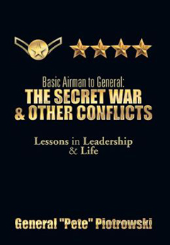
This was merely one of the leadership lessons I learned from this great man, wonderful leader, mentor and friend. I have known General “P” for over 38 years now, and have never seen him lose his cool. He is the consummate professional and, frankly, I could tell General Pete stories all day long, but fortunately I don’t have to because he wrote a wonderful can’t-put-it-down book — The Secret War and Other Conflicts — about his life and the lessons he learned during his almost 40-year career in the USAF. There are many more stories like the one you just read, and at the end of each chapter in his book are the lessons he learned and that he hopes we all learn as well.
GPS Connection
There is, of course, a definite GPS/PNT connection, even though I am reasonably sanguine General Piotrowski did not have that in mind when he penned this 715-page tome of military life and knowledge. Every scenario in this very educational book that relates to military operations and/or training has the same theme for aviators everywhere.
There I was trying to figure out where I was, where the target or destination was, and how I could get there, and once there how I could deliver my ordnance, my passenger(s) and/or just get the aircraft safely back on terra firma.
In this regard, and so many others, General Pete is right on the money, and he should know. Like many of us, including General Curtis LeMay, he trained as a navigator and an aviator.
Take the AWAC E3 aircraft and the whole support system that surrounds it. How did the introduction and integration of GPS change those operations and procedures? To say the least, the changes GPS enabled were drastic — revolutionary versus evolutionary — to those of us who have experienced pre- and post-GPS AWAC flights.
The most obvious change both to the AWAC organization and to the USAF, as it pertains to the rated career field, is that the navigator position was eliminated on the E3 and several other large flight-crew-type aircraft. The navigator planned all the missions for the aircrew, including the flight route (on the ground and inflight), planned and ran the rendezvous for the air refuelings (typical AWAC sorties average 14 hours), and trained with and used a sextant (sun, moon and stars) for navigation in case in war time the electronic navigation aids were unavailable. The navigation system supplied the position, time and velocity references to the mission end of the operation. That crew position and all the manual functions associated with it were eliminated when GPS was installed on the aircraft. The operations still had to be performed and the mission successfully completed, but GPS proved to be so accurate and provided such reliable information that the navigator position was no longer necessary. The position and timing accuracy sent from the navigation hardware and software to the mission computers improved to the point it was accurate to the centimeter level — versus thousands of feet with the old system.
In the old, pre-GPS days, the navigator or pilot would initialize a time hack for all crew members and members of a flight so that everyone had the same time reference as the lead pilot or aircraft. That timing was — five, four, three, two, one hack! — accurate to a whole second and no more. Today, GPS provides continuous atomic-clock-level global timing for everyone. All systems onboard the aircraft, as well as the ground interfaces and communications systems, are accurate to over a millionth of a second and no time hacks are necessary.
Additionally, in the pre-GPS days, aircraft — even the versatile E3, which is capable of and has historically fulfilled the functions of an FAA Control facility for aircraft — mostly flew airways over CONUS and used Federal Aviation Administration radio-based navigation aides such as TACAN (Tactical Air Navigation), VORs (VHF-Very High Frequency Omni Directional Radio Range systems), VORTACS and DMEs (Distance Measuring Equipment) to determine their position while the navigator practiced his craft. However, go feet wet — that is, strike out over water where none of those navigation aides exist, en route to Hickam AFB, Hawaii, for instance — and all of a sudden the navigator became the most important member of the crew. Today’s AWAC aircraft and most modern GPS-equipped military aircraft are able to fly direct to any point in CONUS or anywhere on the globe, saving thousands of hours of flying time, wear and tear on the aircraft and crew, and of course fuel and money. The savings are practically incalculable, but certainly run into the hundreds of millions if not billions of dollars a year. Plus, from a military point of view, the safety factor of putting bombs on target the very first time, day or night, from any location on the Earth cannot be accurately calculated, especially when you consider the number of lives saved.
In WW II, in Vietnam and even in Korea the U.S. Army Air Corps and USAF would fly hundreds and then tens of sorties, endangering thousands of lives, just to take out a single bridge that a single JDAM (Joint Direct Attack Munition) or any GPS-guided weapon today can take out from such a distance that the aircrew may never actually see the bridge, but be certain to a high degree that it was destroyed with a single weapon and a single sortie.
Ask any pre-GPS navigator or aviator, and they will tell you that the biggest error in any bombing mission was always target error. This error extended to exactly where the target was located, how it was defended and how it could be destroyed. With modern GPS weapons, all those variable target errors are greatly minimized. Human lives may not be involved as GPS is capable of providing the PNT information necessary for a UAV (unmanned aerial vehicle) to perform the mission, sans any threat to the pilot or weapons systems officer, who may well be thousands of miles away from the fight.
So, back to General Pete’s book. As you read this wonderful compendium of Air Force lore and knowledge and become involved in the scenarios of just getting to and from the targets in war time, to airfields in bad weather and home again through the clouds, think from time to time about how GPS has greatly simplified all those tasks and made them infinitely doable. Indeed, this 715-page aeronautical volume is one of the best arguments for GPS/PNT systems I have ever read.
Basic Airman to General: The Secret War and Other Conflicts – Lessons in Leadership and Life
This remarkable manuscript is so much more than the biography of a two-striper airman that retired as a four-star general. Amazing as that accomplishment is, the true value of the book is in the journey it took to get there — the life lived and lessons learned.
True to form, General Pete pulls no punches in his biography – in print as in life what you see with General Pete is what you get. He is honest to a fault, and is as critical of himself as he is the United States Air Force he loves and served in uniform for almost 40 years. I recommend this book as an Air Force primer to anyone thinking of joining the military and to members of Congress who never served in the military, and unfortunately that number stands at 80% today, because truly they (Congress) don’t have a clue what putting your life on the line to defend your country means. They have no idea what flying, fighting and dying for your country means. They have no idea of the sacrifices made by USAF military forces on a daily basis.
Treachery
Unfortunately, during the Vietnam War there was a very revealing event that highlights a major failing of civilian leadership that cannot be reconciled or apologized for but is still a major lesson that must be learned by everyone in the U.S. military and in the U.S. government. General Piotrowski reveals treacherous acts by the Kennedy and Johnson administrations that literally took my breath away. It made me physically ill. I have to admit I was gasping for breath after I read it and I had to sit down. I was so shocked that I read it several times and still had trouble believing what was revealed. Don’t get me wrong, I certainly never doubted General Piotrowski’s veracity concerning the politician’s confession; I was and am still just amazed that anyone in the U.S. government in any position of power could be so ignorant and criminally naive. General Piotrowski reveals stunning facts about the Vietnam War on pages 246-247 of his 715 page-turner of a book that shook me to my core. General Piotrowski writes:
“Nearly twenty years later, [ed. after the Vietnam War ended] I saw former Secretary of State Dean Rusk being interviewed by Peter Arnett on a CBS [ed. CBC] documentary called “The Ten Thousand Day War.” Mr. Arnett asked, “It has been rumored that the United States provided the North Vietnamese government the names of the targets that would be bombed the following day. Is there any truth to that allegation?”
To my astonishment and absolute disgust, the former Secretary responded, “Yes. We didn’t want to harm the North Vietnamese people, so we passed the targets to the Swiss embassy in Washington with instructions to pass them to the NVN government through their embassy in Hanoi.” As I watched in horror, Secretary Rusk went on to say, “All we wanted to do is demonstrate to the North Vietnamese leadership that we could strike targets at will, but we didn’t want to kill innocent people. By giving the North Vietnamese advanced warning of the targets to be attacked, we thought they would tell the workers to stay home.”
No wonder all the targets were so heavily defended day after day! The NVN obviously moved as many guns as they could overnight to better defend each target they knew was going to be attacked. Clearly, many brave American Air Force and Navy fliers died or spent years in NVN prison camps as a direct result of being intentionally betrayed by Secretary Rusk and Secretary McNamara, and perhaps, President Johnson himself. I cannot think of a more duplicitous and treacherous act of American government officials. Dean Rusk served as Secretary of State from January 21, 1961, through to January 20, 1969, under President John F. Kennedy and Lyndon B. Johnson. Perhaps Senator John McCain, POW for five years and presidential candidate in 2008, was one of the many victims of this utter stupidity and flawed policy flowing from President Lyndon B. Johnson. Mr. Peter Arnett opined that this would be a treasonous act by anyone else.”
After reading this horrendous revelation, I was so shocked I couldn’t function properly for the rest of the day. I am still aghast and incredulous that government officials could be so deceitful. I lost so many friends, aviator comrades and loved ones in that terrible war, including my father who was literally eaten from the inside out by parasites and the drugs and alcohol he used to try and dull the physical and mental pain and anguish. There are still tens of thousands of veterans suffering today from the effects (such as PTSD – post traumatic stress disorder) of that war, and to think that our government leaders at the highest levels told our enemy what our targets would be on a daily basis because they cared about Vietnamese civilian casualties. Seriously, we were at war. Obviously the administrations, especially the SECDEFs and Secretary’s of State, did not care about American lives, especially American fliers. You can never hope to win a war when all of your targeting information is being treacherously given to the enemy on a daily basis. I am still incredulous they could be so treacherous.
Lessons Learned
Yes, this is sensational and revealing, and there are obviously lessons to be learned — indeed, lessons that the current administration could, should and indeed must learn — such as allowing military professionals to do what they do best and stop micromanaging the Defense Department. But this represents merely a handful of lessons, and this book, this wonderful tome concerning life and leadership at all levels from basic airman to four-star general, is such an educational tool for today’s leaders that it needs to be required reading at all the service academies, certainly the United States Air Force Academy (USAFA). But you don’t have to be in the government or the military to enjoy and learn from the life lessons presented here. General Piotrowski is incredibly honest about his triumphs, his failures, his family life, and his service. He is brutally honest and self-effacing concerning the effects of time spent away from his family defending his nation. Not only in wartime, but during the Cold War as well. For example, remember AWAC aircraft at the time had no CONUS (Contiguous United States) mission, so all the missions were flown overseas. I flew AWAC missions for nine years, average sortie length 12-14 hours, including four years flying NATO AWAC aircraft from Geilenkirchen, Germany, and one year in Iceland. The other four years I was TDY (temporary duty) overseas an average of 220 days per year. General Piotrowski did the same and more, and believe me, it is a huge sacrifice for the service member and their families.
So, there is a lot of good fatherly advice in this book, and I only wish someone like General Pete could have written this book 40 years ago when I was a young lieutenant.
The bottom line is the title says it all: Basic Airman to General; The Secret War and Other Conflicts — Lessons in Leadership and Life. Get a copy today, you won’t be disappointed.
Until next time, happy navigating, and remember: GPS is brought to you courtesy of the United States Air Force.
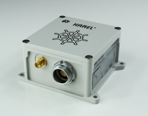
The VIA-100G GPS/IMU by Karel Electronics. Photo: Karel Electronics
The VIA-100G, an integrated GPS and MEMS-IMU (inertial measurement system), has been added to the ViaNav inertial navigation system family produced by Karel Electronics Corporation.
Featuring a high-accuracy fusion filter running on an embedded processor, the VIA-100G provides all the functions of a vertical reference unit (VRU), an attitude and heading reference system (AHRS) and integrated GPS/IMU system. The system contains GPS, 3D gyroscopes, 3D accelerometers, a magnetometer, a static pressure sensor and temperature sensors in a compact and rugged enclosure. The embedded processor provides driftless and real-time navigation information over a wide range of temperature in dynamic and static conditions, Karel said.
The sensors are integrated with a highly accurate fusion filter. A Kalman filter running on an embedded processor fuses data from the IMU, GPS, magnetometer, altimeter and barometer in an optimal manner to output highly accurate navigation solutions. VIA-100G outputs high-frequency position, velocity and attitude information in addition to calibrated 3D acceleration, rotation, magnetometer and pressure data.
The ViaNav product family includes other navigation products designed to be used in stability, guidance, control and navigation applications in industry. The VIA-100 line includes:
VIA-100I, is an inertial measurement unit with 3D accelerometers and 3D gyroscopes.
VIA-100A, is a 3 DOF AHRS that provides driftless real-time orientation information over the full 360 degrees of angular motion on all three axes. It includes 3D accelerometers, 3D gyroscopes and 3D magnetometers.
VIA-100A+, is a 3 DOF AHRS that provides driftless real-time orientation information. It includes a multi-IMU configuration and employs an optimum filter to lower IMU noise level. It provides 3D orientation with improved accuracy and reliability.
EuroGeographics and EuroSDR have announced that they will work together to provide a framework for European spatial data research and development.
The cooperation agreement will further the development of the EuroSDR Research Plan and the activities of the EuroGeographics Knowledge Exchange Networks. As a result, members of both not-for-profit organizations will benefit from greater opportunities for professional development. They will also be able to take part in joint projects and hand over tasks more appropriate to the other organisation’s expertise.
“We have a common interest in carrying out and applying relevant research and developments in the field of geographic information and spatial data infrastructures,” said Ingrid Vanden Berghe, president of EuroGeographics, the membership association of the European National Mapping, Land Registry and Cadastral Authorities.
“With rapid technological advances generated by a digital information society, the time from research via development to operation has never been faster. This agreement will ensure our members remain up to date with and understand the possibilities presented by new technologies and methodologies so they can react more quickly to user demands.”
Martin Salzmann, president of EuroSDR, which links national mapping, land registry and cadastral authorities with research institutes and universities in Europe, added: “Achieving synergy in our activities benefits both our members and society by strengthening research and development, sharing results of common interest and making these operational. At the same time, we will foster and stimulate a vibrant research community with which to capitalise on future technologies and to be responsive to user demands. By working together we also avoid the risks of duplication of work between us and our member organisations.”
EuroGeographics and EuroSDR are both committed to supporting wide range of initiatives that will benefit people across Europe, the companies said. These include the European Spatial Data Infrastructure, Copernicus, Galileo, Horizon2020, European Location Framework and the European Digital Single Market.
Rohde & Schwarz adds ERA GLONASS to its reliable test solution for in vehicle emergency call systems. Photo: Rohde & Schwarz
Effective January 1, 2015, all new car models introduced to the Russian market must be equipped with the automatic ERA-GLONASS emergency call system. Rohde & Schwarz now offers a standard compliant test solution for manufacturers and suppliers of these in-vehicle systems.
Rohde & Schwarz is demonstrating its ERA-GLONASS test setup at Mobile World Congress, being held this week in Barcelona, Spain.
The test setup consists of the R&S CMW500 wideband radio communication tester and R&S SMBV100A vector signal generator as a GNSS simulator. This setup allows manufacturers and suppliers of automatic in-vehicle systems (IVS) to perform reliable and reproducible pre-conformance tests on their ERA-GLONASS modules in the lab.
In the Russian Federation, ERA-GLONASS works much like the European Union’s eCall system. When an accident occurs, the IVS connects with a public safety answering point (PSAP) via the local wireless communications network and transmits a standardized minimum set of data (MSD). In addition to GLONASS or GPS coordinates, the MSD also contains data with information about the accident vehicle as specified in ERA-GLONASS. If no voice connection can be made or if data cannot be transferred via the voice channel, the MSD is sent to the PSAP via SMS. This fallback option is a special ERA-GLONASS feature. The Russian system is also certified for 2G and WCDMA networks.
Rohde & Schwarz developed its R&S CMW-KA095 application software to meet ERA-GLONASS requirements in line with Russia’s GOST specification. Based on the R&S CMW-KA094 eCall software, the R&S CMW-KA095 simulates a PSAP and controls the R&S CMW500 emulating a wireless communications network in the lab. The software also controls the GNSS simulator that supplies the coordinates required for vehicle localization. With this solution, users can verify whether their IVS modem is able to successfully initiate an emergency call, transmit the correct MSD and establish a voice connection with a PSAP. The results are interpreted in line with the GOST specification.
The ERA-GLONASS SMS protocol has also been integrated into the test solution, making it possible to test the SMS functionality of the IVS modem when no voice connection is available.
The test solution is fully automated because of the R&S CMWrun sequencer software. The R&S CMW-KT110 eCall/ERA-GLONASS test package provides a user-friendly, automated functional test in line with GOST55330, enabling users to verify the operability of an entire system in the lab and document it in a report.
Editor’s Note: Alan Cameron is editor-in-chief and publisher of GPS World magazine. He also writes the monthly GNSS Design & Test newsletter. The views expressed are his own.
“It’s tough to make predictions, especially about the future.” This insight comes from the 20th-century American sage Yogi Berra. Yet predictions — hedged guesses, if you will — form the basis of nearly all new business ventures and decisions in ongoing business activities.
For surveyors in the year 2015, one of the key predictions — or guesses — to make concerns the next GNSS to come predictably and reliably online, to augment GPS where GPS alone does not fully function: under canopy, in dense urban environments, and so on. More satellites visible at more varied angles in the sky can help surmount these obstructions.
Staking the future of one’s business, in the form of new equipment acquisition, in such an environment is a bit like betting on a long-distance horse race. First one steed surges to the head of the pack, then it falls back as another charges forward. We have seen this pattern repeatedly in the growth of GLONASS, Galileo and BeiDou.
Some may say that GLONASS, the Russian system, has already won the race (the first heat, at least) and currently fills the role of GPS partner in precision surveying. It does, to some extent, but its future viability is cloudy — and its past record is patchy, to say the least. It rose to full operational capability around the turn of the century, then fell very, very low in numbers as short-lived satellites expired and were not replaced at sufficient rate. Recently, GLONASS has mounted a resurgence, but that has been marred by repeated launch failures and a disturbing anomaly. It cannot be counted or confirmed a winner, yet.
I spoke yesterday with an expert and veteran professional land surveyor who expressed the opinion that the manner in which surveying is conducted will change more in the next five years than it has in the last 25. Keep in mind that the last 25 years saw enormous changes themselves, as GPS significantly transformed, upgraded and made vastly more efficient most surveying activities.
Betting on a horse race in such a rapidly changing environment becomes even more chancy.
Here’s a tip from a racetrack tout: don’t count Galileo out.
GLONASS we recounted briefly above. BeiDou recently achieved a regional operations status over Eastern Asia, but further developments there have been puzzlingly quiet for some time.
The European system has come on with agonizing slowness since the year 2000, suffering many delays and most recently what could have been a debilitating failed dual launch. But the combined strength of the European Union continues to push determinedly forward, and the program has an ambitious schedule with an eye firmly fixed on operability. And some recent research results tend — perhaps — to substantiate the claim, long pooh-poohed by those in the United States, at least, that Galileo will eventually prove “better” than GPS. Details further on.
What might a prudent yet pragmatic, forward-looking surveying firm do in this uncertain environment, where the only certainty is change, and likely to be rapid change at that? Here’s another racetrack tip: don’t make any big bets just yet, but study the field closely and continuously. In particular, watch Galileo’s performance.
A further item to be checked in Galileo’s favor: its system operators have long been in close talks with the U.S. government on many matters involving co-operation and interoperability. As recounted in a recent story concerning the Federal Communications Commission’s surprising role in this matter, the Europeans are filling out the proper forms for full accreditation within the United States. This could turn out to be important in business operations.
Back to studying the field closely: also study leading manufacturers’ offerings in this regard. They also are making bets on the future; quite possibly they have better information, and/or have done more extensive analysis of what information is available, paired with in-depth, highly technical research and development of signal characteristics and how signals from disparate GNSS can be most productively combined.
A quick scan of GPS World’s2015 GNSS Receiver Survey shows the following key manufacturers (among others) have GPS receivers now commercially available that are Galileo-ready: Altus Positioning Systems, Ashtech, Geneq, iFEN, JAVAD GNSS, Leica Geosystems, NovAtel, NVS Technologies, Septentrio, Sprecta Precision, Spectrum, Topcon, and Trimble.
Better than GPS???
Supporters of Galileo have long raised hackles west of the Atlantic with claims that Galileo would provide better accuracy than GPS. Not! cried the faithful, and especially not when the modernized and improved, strengthened, more accurate GPS III signals are coming along just as fast if not faster than Galileo. Recently the pace of GPS III has come into question; can the Gold Standard and clear leader for 25+ years really be falling back into the pack?
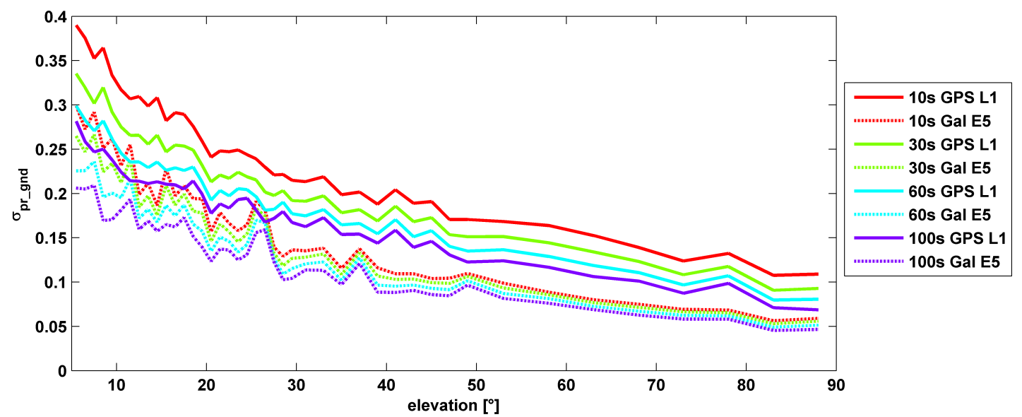
σ(pr_gnd) versus elevation for Galileo E1 (dotted lines) and GPS L1 (solid lines for different smoothing constants: red (10s), green (30s), cyan (60s), purple (100s).
Let’s disregard that question for the time being, and look at some recent research, to be reported in full in the cover story of GPS World magazine’s April issue, out soon. In it, the authors (two German and one American researcher) report:
“Analysis of new Galileo signals at an experimental ground-based augmentation system (GBAS) compares noise and multipath in their performance to GPS L1 and L5. Raw noise and multipath level of the Galileo signals is shown to be smaller than those of GPS. Even after smoothing, Galileo signals perform somewhat better than GPS and are less sensitive to the smoothing time constant.”
This is all pretty arcane and a bit removed from current field of operations, as far as surveyors are concerned. But it does signal something, and it provides food for thought.
The researchers obtained their results using four JAVAD Delta receivers, all connected to Leica AR 25 choke ring antennas.
Geomatics USA from Gainesville, Fla., has designed a precision surveying and mapping system that can be easily stowed in an overhead compartment for airline travel. Surveyors can fit everything needed for important mapping and surveying jobs into a baseball-style bag, including tripods. The compact, light-weight system offers differential sub-foot accuracy.
Components easily pack into a baseball-style case.
The G1-m1 receiver system has many advantages over conventional GNSS receivers, Geomatics said. The system is designed for precision surveying jobs that require travel to remote areas of the world, and for traveling to job sites by commercial airline. The complete base and rover kit, including the tripods, rods, and batteries, fits into a single baseball style bag and weigh less than 10 kg, making it easy to stow as carry-on luggage.
The Geomatics USA G1 system is scalable from a simple single-frequency semi-mobile receiver — ideal for control networks and some semi-kinematic mapping applications — to a dual-frequency network RTK solution. All of the Geomatics USA G1 solutions perform precision-quality tasks at a fraction of the cost of major-brand equipment.
The G1-m1 system comes with a free processing software license for the first 50 systems that supports carrier-phase relative positioning and CA-code differential correction. The software is designed with a simple user interface for easy selection of base and rover data or automatic data download of the closest Continuously Operating Reference Station (CORS) from the U.S. National Geodetic Survey database. It is compatible with other RINEX based post-process systems around the world.
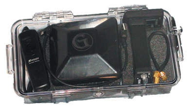
Complete survey set including GNSS receiver, antenna, battery and cables, fits in a small handheld plastic case.
According to Geomatics USA Chief Technology Officer Ahmed Mohamed, “The G1 product line fills the gap between survey applications, where cm-level precision is an absolute necessity, and mapping applications, where meter-level precision is acceptable. In fact, the G1-m1 product offers sub-foot precision in most cases and cm-level precision in ideal situations. Geomatics USA uses readily available components and open-source code to develop its end user product solutions. The objective is to make sure the software performs correctly with a very short learning curve for the user.”
For a limited time, Geomatics is offering a specially priced configuration for the first 50 systems through NavtechGPS, its worldwide distributor.