Category: Applications

  • On the Edge: The Precision to Carry On

    On the Edge: The Precision to Carry On

    Components easily pack into a baseball-style case. Photo: Nicholas DiGruttolo
    Components easily pack into a baseball-style case. Photo: Nicholas DiGruttolo

    By Nicholas DiGruttolo

    When asked to do a small survey job overseas, we were concerned about shipping bulky and expensive survey equipment. Shipping costs are not trivial. Add to that the real possibility that your survey equipment may be confiscated by the local authorities, as ours was in Djibouti, and the cost of shipping equipment becomes a substantial part of the overall job. There should be alternatives, especially if accuracy requirements are not stringent.

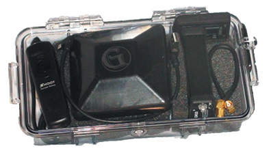
    Faced with this problem for a second time, we considered a new receiver system that has many advantages over conventional survey-grade GNSS receivers: It is small, lightweight and low-cost without sacrificing performance, making it ideal for precision surveying in remote areas of the world and for traveling to the job site by commercial airline. All the components, including the tripods, rods and batteries, are constructed from commercial off-the-shelf (COTS) components. A complete base and rover kit fits in a baseball bag and weighs less than 10 kilograms. The kit is sized and approved as carry-on luggage.

    The system is scalable from a simple single-frequency semi-mobile receiver for control networks and some semi-kinematic mapping applications, to a dual-frequency network RTK solution.

    The system comes with free processing software that supports carrier-phase relative positioning in real time and post mission, as well as precise-point positioning (PPP) and CA-code differential correction. The software is designed with a simple user interface for easy selection of base and rover data or automatic data download of the closest Continuously Operating Reference Station (CORS) from the U.S. National Geodetic Survey database.

    complete survey set including GNSS receiver, antenna, battery and cables, fits in a small handheld plastic case.
    Complete survey set including GNSS receiver, antenna, battery and cables, fits in a small handheld plastic case. Photo: Nicholas DiGruttolo

    The system fills a gap between survey applications, where centimeter-level precision is an absolute necessity, and mapping applications, where meter-level is tolerable. The product offers sub-foot precision in most cases and centimeter precision in ideal situations.

    Our team recently performed topographic mapping of an oil refinery site in Saudi Arabia and surveyed a precise-elevation network in Sarasota, Fla., to research the effects of sea-level rise. The small size of the COTS components simplified transport to Saudi Arabia, eliminating additional airline baggage fees and easing import through customs. Researchers performing the sea-level study reduced field time by increasing the number of receivers needed to observe a robust vertical control network.

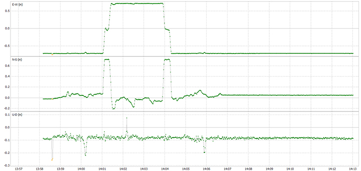
    Oil Refinery. The oil refinery project entailed mounting a GNSS antenna on the roof of an off-road vehicle and driving multiple transects around the 18-kilometer perimeter of the site to record the elevation of the terrain. Kinematic data was recorded at 1 Hz using a GPS-only version of the single-frequency receiver. Baseline length to the local reference station varied from less than 1 kilometer to about 10 kilometers. The site was open desert with no overhead obstructions or sources of multipath other than the roof of the vehicle on which the antenna was mounted. Post-processing and comparison to simultaneously collected data from a high-precision survey-grade receiver revealed positional accuracy of about 5 centimeters horizontal and 10 centimeters vertical, when the system’s trajectory was compared to the truth trajectory provided by the survey-grade receiver. Figure 1 shows the difference between the two trajectories. The system’s antenna was 2 feet away from the survey-grade antenna along the driving direction of the vehicle; the trajectory was mostly in the north-south direction and hence the 0.6-m offset in the plot!

    Figure 1. Antenna location difference in the sub-decimeter range between the survey-grade system and the compact low-cost system. Note: A 0.6-m offset is to be removed from the difference, as the two antennas were mounted 0.6 m apart in the vehicle driving direction.
    Figure 1. Antenna location difference in the sub-decimeter range between the survey-grade system and the compact low-cost system. Note: A 0.6-m offset is to be removed from the difference, as the two antennas were mounted 0.6 m apart in the vehicle driving direction.

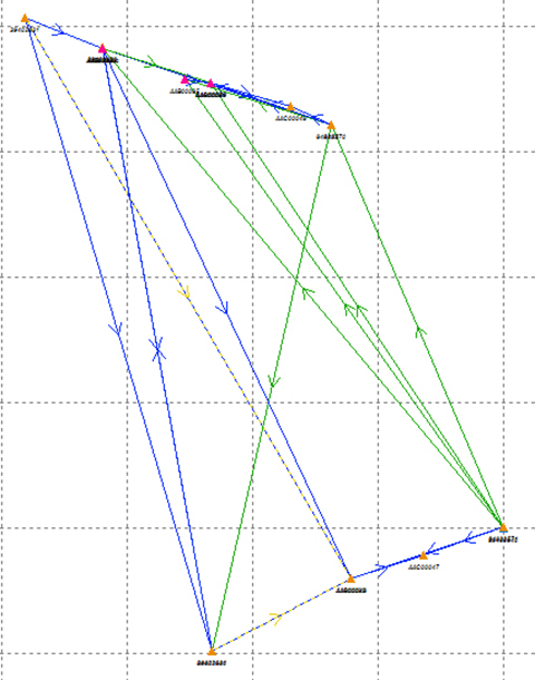
    Sea Level. The sea-level-rise study required a high-accuracy vertical control network to cover a 2,500 hectare area. The purpose of the network is to determine the shortest term effects of sea-level rise with a rate of 1.8 millimeter/year in the affected area. Ten benchmarks were established throughout the area of interest, and a robust network of static observations was performed with a combination of two dual-frequency and two single-frequency receivers. The single-frequency receivers were GPS-only units where two standard 4-inch patch antennas were mounted on rods adjusted to a 0.9-meter height. The addition of two receivers provided greater redundancy and a stronger network solution in much less time than would have been possible with only one pair of survey-grade receivers. Figure 2 shows the addition of several loop ties to the network as a result of adding the two roving, lightweight receivers.

    Figure 2. Sea-level rise monitoring network showing increased tie points and redundancy as a result of adding the extra lightweight precision receivers to the survey-grade receivers.
    Figure 2. Sea-level rise monitoring network showing increased tie points and redundancy as a result of adding the extra lightweight precision receivers to the survey-grade receivers.

    Manufacturers

    The system described in this article is the G1 system developed by Geomatics USA, LLC (www.geomatics.us; see also www.navtechgps.com).


    Nicholas DiGruttolo works as a field surveying manager for JBrown Professional Group Inc., Northrop Grumman Corporation, and has recently become vice president of surveying.

  • Expert Advice: A Leap into the Unknown?


    By Mark Sampson

    A leap second will be introduced this year at 23:59 on June 30. This phenomenon comes around periodically and is necessary for keeping Coordinated Universal Time (UTC) in line with the small vagaries of the Earth’s slowing rotation. Although it is an event that will pass unnoticed by the majority of people, it has implications for anyone involved in the development of GNSS-enabled devices. For some, it can be the cause of a major headache.

    Part of the problem with the leap second is its irregularity. Occurring every two or three years, it means that receiver technology moves on in between — and because the Earth’s slowing rotation is not at a constant rate of change, it cannot be predicted when the next one will be announced. A rapidly developing market of GNSS products having to deal with random alterations to its time framework is not an ideal situation. Suitable preparations, clearly, should be employed.

    The behavior of a new receiver when subjected to a leap second may prove critical in certain instances, and without robust characterization it can lead to inconsistent performance. It has already happened this year: on January 21, GPS signals started to include information which effectively announced this year’s leap second event, with the relevant data for future delta time, and week and day numbers. This caused issues with some receivers that weren’t expecting it: some units applied the additional second immediately. It would be interesting to see how these systems might have reacted during an actual leap second transition.

    Receiver logic flow requires testing so that any GPS receiver can remain compliant with the IS-GPS-200 standard, and potential problems must  be mitigated and controlled. The use of a GNSS simulator — which outputs a scenario containing the leap second event — allows for the receiver and any systems around it to be exercised over and over again, ironing out any anomalies, to ensure total reliability.

    The recent issues with those non-compliant GPS engines highlights the advantage that simulation provides. The consistency it delivers enables a very thorough testing schedule, which will in turn lead to a straightforward application of the time change.

    One school of thought holds that leap seconds should be abandoned, and that we should stick to atomic time from now on. Their removal would mean that by 2100, the Earth’s rotation would be some two to three minutes behind humanity’s precise, atomic-powered, 24-hour clock, and half an hour or so by 2700.

    The World Radiocommunication Assembly, which has control over such matters, had been postponing a decision on whether to abolish the leap second for over a decade; another vote is due this year. It wouldn’t be any great wonder if this prevarication continues, so whilst it still exists, it is best to concentrate on what this June’s extra second might have in store for anyone currently developing a GNSS product. Armed with a simulator, the unpredictability of leap second scheduling should no longer be a major concern. Should this year’s vote be again inconclusive, those who have taken the positive step of acquiring a GNSS simulator will be in good shape to deal with the next time the clocks show 23:59:60.


    Mark Sampson is LabSat product manager for RaceLogic.

  • UAV Pavilion, Hologram Room on Tap at SPAR International

    SPAR International is a platform-neutral conference and exhibition focused on end-to-end business and technology for 3D measurement and imaging for industrial facilities; engineering, architecture and construction; and civil infrastructure. The exhibition will showcase solutions from leading 3D hardware manufacturers, software suppliers and service providers.

    The conference and trade show will be held March 30-April 2 in Houston, Texas.

    Watch a video about the conference:

    At SPAR International, current and emerging 3D technology and lifecycle asset-management solutions will be highlighted. More than 90 experts in 3D data, point-cloud processing, and data delivery will explain how to improve processes, mitigate risk, get the necessary output, and save time and money.

    This year SPAR features a dedicated UAV pavilion, where attendees can learn about the market and discuss solutions with major manufacturers. It also features a hologram room — a taste of the future that puts you inside a 3D scan.

    On the exhibit floor, developers and manufacturers will showcase the latest solutions developed to solve pressing and complex problems in a range of industries. 3D scanners, low-cost handheld devices, mobile mapping solutions, advanced data processing workflows, and more will be featured.

    Learning levels for 2015 include:

    • Business Consideration: Critical topics for asset owners and business leads.
    • 3D Technologies and Applications: In-depth content for 3D pros.
    • Introduction to 3D Tools: Basics for beginners and those new to 3D.

    Other topics covered include:

    • Building Information Modeling (BIM)
    • 3D for asset and facilities management
    • 3D data capture for as-built conditions
    • Point-cloud processing
    • Managing and sharing large data sets
    • 3D/intelligent modeling
    • Augmented reality and visualization tools
    • UAVs/UAS

    Numerous networking events provide opportunities to gain valuable information from other precision-measurement and imaging professionals across disciplinary lines. Attendees can discuss best practices, share project experience, and benefit from the experiences of their peers.

    Registrants include professionals from:

    • BP
    • Burns & McDonnell
    • Chevron
    • Doosan Babcock
    • Ford
    • General Motors
    • Hensel Phelps
    • Jacobs
    • Lockheed Martin Space Systems Co
    • NASA Newport News Shipbuilding
    • Pacific Gas and Electric Company
    • Parsons Brinckerhoff
    • Pepper Construction Company
    • SBM Offshore
    • SNC-Lavalin
    • The Beck Group
    • Whiting-Turner

    Click here to register.

  • Microsemi GNSS Master Solves Small-Cell Synchronization Issue

    Microsemi-IGM-Solution-WMicrosemi Corporation is offering a new Integrated GNSS Master (IGM) solution for small-cell synchronization. The IGM is the company’s first solution that fully integrates a 1588v2 PTP grandmaster with a GNSS receiver and antenna in a small, fully contained package, designed to mount indoors.

    The Microsemi IGM solves the challenge of indoor synchronization, which has been a significant hurdle for cost-effective small cell indoor deployments.

    According to the Small Cell Forum, 80 percent of small cell needs are for indoor use. Microsemi expects the company’s new IGM to revolutionize indoor small cell deployments by eliminating the need for an antenna on the rooftop along with expensive power, cabling and installation costs associated with connecting the GNSS antenna to the 1588 grandmaster in a typical small-cell deployment.

    IGR reports that the cost to deploy a small cell is approximately $31,000 on average and much higher than the cost of the small cell itself. Similarly, the cost of deploying a GPS antenna on a roof is typically $15,000 to $25,000 and can go up to $60,000 in high-rise buildings, in addition to the roof rental expense on a yearly basis.

    The Microsemi IGM eliminates the need for an outdoor antenna and therefore significantly reduces the purchase, installation and maintenance deployment costs for typical GNSS antenna systems. The sensitive GNSS receiver and patented Microsemi timing algorithms result in an indoor GNSS timing solution that can be deployed in many different indoor environments.

    The IGM uses Power-over-Ethernet (PoE) to simplify installation by utilizing standard Ethernet within a facility and requires no more than 12.95 watts of power directly from the Ethernet cable. The IGM is mounted on the wall or ceiling, connected to the network via PoE, and the unit will automatically self-configure, lock to GNSS signals and provide precise frequency and phase with its 1588v2 PTP grandmaster needed for small cell operation.

    Microsemi-IGM-diagram-W

    “The IGM product introduction is a continued commitment from Microsemi to address market and customer challenges in timing and synchronization,” said Eric Colard, director of marketing and business development for Microsemi’s Frequency & Time Division. “The IGM solution complements our flagship timing products and will work with them in tandem to provide a truly end-to-end timing and synchronization solution.”

    “Deploying small cells indoor to provide better coverage and enhance capacity is becoming a priority for operators,” said Richard Webb, Analyst, Mobile Backhaul, at Infonetics, recently acquired by IHS. “The challenge of tight synchronization requirements for LTE has been difficult to solve; Microsemi’s IGM innovative solution enables mobile operators to precisely synchronize small cells indoor and lower deployment costs.”

    “The time is right for such an innovative and disruptive solution as IGM from Microsemi,” said Earl Lum, president, EJL Wireless Research. “Since Small Cells for indoor are now being readily deployed, Microsemi solves a critical cost issue and technical challenge operators are facing. The compact form factor, plug and play capability, and scalable client support of the IGM product hits the sweet spot for indoor small cell projects.”

  • LocationSmart, Locaid to Merge for Cloud-Based Location Services

    LocationSmart, a provider of cloud-based location and interactivity services, and Locaid, a location-as-a-service platform for enterprise location, have merged to create an enterprise mobility platform for cloud-based location services.

    The merger agreement was unanimously approved by the boards of directors of LocationSmart and Locaid, and stockholders of both companies approved the merger on Feb. 19.  The combined company will operate under the LocationSmart brand.  In conjunction with the merger, LocationSmart secured equity and debt financing led by Intersouth Partners and Hamilton Lane (Florida Growth Fund) to integrate operations and accelerate growth initiatives.

    Mario Proietti will continue as CEO of LocationSmart, and Locaid founder and CEO Rip Gerber will serve on the company’s board of directors and as a strategic advisor.

    “We are excited that we could join together the two preeminent enterprise location platforms in the industry to better serve our collective customers,” Proietti said. “Working together will enable us to deliver a richer and more robust set of location services that translate into better solutions for our clients. The innovations delivered through our award-winning platforms will continue to lead the market in meeting their needs to locate mobile consumers, workers and assets anywhere, anytime and on any network.”

    “This unification of our location platforms is compelling,” Gerber said. “By joining forces, we provide a broader set of location enabling solutions to our enterprise customers, and serve as a more strategic service delivery channel for our wireless carrier partners.  This strategic combination makes us very formidable in every part of the mobile location-enabled world.  I am delighted that we were able to join the businesses together.”

    This combination creates a worldwide cloud-location platform with a customer base of more than 200 brands and companies locating millions of end users to enhance their services and business operations. The merger establishes a stronger platform for future innovation within the mobile location industry, providing significant benefits to all constituencies, including:

    • Enhanced and trusted, global location awareness of customers, workers and assets
    • Unified access to a multitude of device location sources with the largest reach in the industry
    • Reliable and highly scalable enterprise-grade location services available in the cloud
    • Fully managed and carrier-approved privacy controls compliant with industry best practices
    • Advancements in international device roaming solutions.

    The LocationSmart and Locaid platforms are employed by the Fortune 500 and other leading companies for mission-critical applications in a number of industries including service assistance, proximity marketing, workforce management, emergency alerting, mobile gaming and transaction verification. Through the integration of the two companies and their platforms, customers will be able to access, through a single unified web services interface, the most robust and comprehensive portfolio of cloud-based location services in the world.

  • Markey Report Concerns Connected Vehicle Industry

    Editor’s note: Dennehy is GPS World’s editor for location-based services, writing a monthly column for the LBS Insider newsletter. The views expressed are his own. He will be covering the Mobile World Congress in Barcelona for GPS World. Contact him at [email protected] with your news. 


    Markey-report

    Sen. Ed Markey’s new car technology report, released earlier this month, basically says that connected vehicles can be hacked, causing danger to drivers and presenting major privacy concerns. While some critics believe Markey’s report was meant to drive media hysteria, others say it raises serious issues that the industry needs to address. In other location news, I’ll be covering the Mobile World Congress in Barcelona for GPS World. What will be the showcased location technology? Wearables? Connected vehicles? Or something new? 

    Kevin Dennehy
    Kevin Dennehy

    By Kevin Dennehy

    A report released by Sen. Edward Markey (D-Mass.) earlier this month says that even though drivers have come to rely on new connected technologies, automakers haven’t done their part to protect them from cyber attacks or privacy invasions

    First reported by CBS News’ 60 Minutes, Markey’s report, Tracking & Hacking: Security & Privacy Gaps Put American Drivers at Risk, includes information from 16 automobile manufacturers who were given questions about security and privacy. However, few of the carmakers’ answers included how vehicles may be vulnerable to hackers — and what driver information is collected.

    Location industry veteran Kim Fennell, deCarta CEO, said the report should be a real concern to the industry. “But it’s more of an issue for autonomous driving and the security of the car’s electronic control system. Even today, the OnStar service, which was a pioneer in the connected car space, can remotely slow your vehicle down in the event of a theft,” he said. “This feature, if hacked, could definitely create massive problems if the proper security technologies are not implemented.”

    Markey’s report raised additional concerns about the use of navigation and other features that record and send location or driving history information.

    Markey-telematicsFennell said there should be a distinction between the infotainment systems in the vehicle and the on-board control systems of the car.

    “We believe that there should be a strict firewall between these systems so that nothing malicious can happen that is initiated from the connected infotainment system. Any data should flow one way — from the control system of the car to the infotainment system,” he said. “This is not to say that the connected infotainment system shouldn’t be secure, it should be. In working with our OEM and Tier One partners, we have implemented strict security protocols between our servers and their apps.”

    Markey’s report found that “[automakers] use personal vehicle data in various ways, often vaguely to ‘improve the customer experience’ and usually involving third parties, and retention policies — how long they store information about drivers — vary considerably among manufacturers.”

    In addition, the report found that customers are often not made aware of data collection and, when they are, they often cannot opt out without disabling features, such as navigation.

    Source: Kenvin Dennehy
    Percentage of Vehicles that can record driving history

    Overall, Fennell hopes that the most malicious thing that could happen in the event of a hack of an infotainment system is that a “Pandora station is changed to play nothing but Justin Bieber songs, the traffic information for your route is projected to be ridiculously long or the Yelp rating of the restaurant that you are going to is lowered down to one star.”

    Ultimately though, the driver should be in control of the car and nothing in the infotainment system should affect the behavior of the vehicle, Fennell said.

    In terms of driver safety, in a recent survey, deCarta found that more than two-thirds of respondents considered dashboard screens that display videos and other Internet content to be the most dangerous types of onboard information systems. Approximately 79 percent of those polled preferred “voice-activated mapping systems that allow drivers to keep their eyes on the road” as an essential safety-enhancing feature.

    “There are two things that infotainment systems could do better to prevent driver distraction. First, instead of replicating the stove-piped app store environment of the smartphone, in-car infotainment services could be better integrated,” Fennell said. “If I find a destination on Yelp, I’d like to send that to my navigation system instead of typing in the address. Second, with today’s better automated speech-recognition technology and text-to-speech engines, it’s now possible to make requests of your infotainment system using natural language commands. Voicebox is doing some great things in this area.”

    Fennell said that most existing systems are not connected. “But those that are, aren’t predictive enough. Your navigation/infotainment system should almost work as a concierge,” he said. “It should recognize what time it is and realize you are most likely leaving for work and offer up the best route based on traffic conditions. It should recognize that you are going to a destination in an urban area and offer the most convenient parking to your destination.”

    Company Rolls out Indoor Positioning Product that Doesn’t Require Retailer Involvement

    After testing and demoing the product in San Francisco last year, IndoorAtlas is rolling out a consumer app called GPSindoor, which uses smartphones to locate shoppers inside a mall. The product features product proximity advertising to allow shoppers to see where they are relative to a product for promotion marketing.

    The product includes a crowdsourcing function to allow user-generated data to build indoor maps, wayfinding and other options for shopping promotions, said Wibe Wagemans, IndoorAtlas president.

    “We don’t need any retailers per se. We need only the shopper and [their] smartphone,” he said. “There is no brand or retailer involvement if you use our app. Unlike Wi-Fi and Bluetooth beacons, since GPSindoor relies on a community of shoppers, it allows for higher accuracy than static maps. That gives us the confidence to take on the giants like Apple Beacons and Google Indoor Maps head on — we are completely independent of retailers and not dependent on them for our success in becoming the GPS of indoors.”

    In other location news:

    • HERE released a new version of its mapping system for Android, saying it made significant improvements. According to the company’s blog, after more than 3 million downloads, it is shedding the “beta” label with this version. In the beta version, when users asked for a route, the app gave them three car routes. If a user wanted public transit or pedestrian routes, they had to switch to the appropriate tab. This process was slow and inconvenient for people who don’t use a car all the time, HERE said.
    • In its recent financial statements, Garmin indicated a growing, and profitable, segment is its wearables/fitness band product line. Mio is also expanding its wearable offerings. This should be a big topic at next months’ Mobile World Congress.

    I’ll be covering the Mobile World Congress in Barcelona for GPS World. Contact me at [email protected] with your news.

  • MWC 2015: Anritsu to Showcase Cloud-Based Connected Car System for Fleets

    Photo: Anritsu
    Photo: Anritsu

    Anritsu plans to showcase a sophisticated, cloud-based connected car system for fleet tracking at Mobile World Congress 2015, which will be held in Barcelona March 2-5. The system was developed by the University of Hertfordshire in the UK with the help of network simulation technology from Anritsu.

    The system will be demonstrated using a GNSS simulator from Spectracom to provide location information to the system being tested.

    The connected car demonstration will show a car’s diagnostics system connecting to the cloud via a simulated LTE network environment provided by Anritsu’s mobile network simulator, the MD8475A. An application in the cloud enables a fleet manager on any Internet-connected device to view the location and operating parameters of any vehicle in the fleet in real time.

    The MD8475A enables the university’s development team to test, from their Hertfordshire laboratory and with a single instrument, how the system’s in-car LTE modem would perform in mobile networks all across the world, and operating according to all major worldwide standards.

    The combination of the MD8475A and the Spectracom simulator provides a complete test environment, to simulate any global location, and any type of cellular connectivity, to ensure correct operation of the system. This test bed will showcase the effectiveness of a complete wireless test-bed solution, to enable cost-effective development testing, product validation, and customer experience evaluation within a single system.

    Anritsu Corporation has been a communications provider solutions for more than 110 years, with test and measurement solutions including wireless, optical, microwave/RF and digital instruments, operations support systems and solutions that can be used during R&D, manufacturing, installation and maintenance.

  • Topcon Partners with Toro on GPS-guided Turf Sprayer

    Topcon Partners with Toro on GPS-guided Turf Sprayer

    Topcon Positioning Group is partnering with The Toro Company to develop a GPS-guided sprayer that Toro will start selling to the commercial equipment marketplace this summer. The GeoLink system will be available for the Toro Multi Pro 5800 initially, with plans to offer it for a broader range of Toro sprayers in the future.

    “We’re thrilled to partner with Toro on our debut in the turf spraying marketplace,” said Jason Killpack, director of business development, strategic partnerships for Topcon.

    Source: GPS world staff
    The Toro Multi Pro 5800 sprayer will get Topcon GPS guidance.

    “This new system, which builds upon Topcon innovations developed for precision agriculture, is an excellent example of how positioning technologies can benefit non-traditional industries. We are taking proven precision agriculture technology and providing it as a resource for Toro to employ in its market,” Killpack said.

    “In addition to working in tandem with Toro to develop this exciting new product, it also provides us the opportunity to expand our TopNETlive network, which is a key initiative within our organization.” The TopNETlive network is a subscription-based, real-time, GNSS reference network delivering high-quality correction data to rovers used for surveying, construction, GIS mapping and agricultural applications throughout North America.

    “We started by understanding customer needs, and then selected Topcon as a partner to develop an integrated user-friendly solution,” said Jace Bertsch, marketing manager for Toro. “We are very excited to offer the unique features that have been engineered into this system, and are confident that GeoLink will be successfully deployed in both the golf and sports field market segments. Simply put, GeoLink ensures accurate and consistent coverage, which translates into exceptional results and reduced chemical costs.”

  • Farmers Edge Acquires GranDuke Geomatics for Precision Agriculture

    Farmers Edge Inc., a precision agriculture and independent data-management company, has acquired GranDuke Geomatics Ltd. of Lethbridge, Alberta. The agreement was finalized on Jan. 9, giving control of the geospatial solutions and software development company to Farmers Edge.

    Headquartered in Winnipeg, Canada, Farmers Edge has operations in North and South America, Australia, Russia and Eastern Europe. The company said it’s goal is to increase growers’ profitability maintaining an environmentally sustainable approach by leveraging advanced precision tools and big data analytic solutions.

    Farmers Edge offers its Precision Solutions package for every agribusiness, crop and geography. Precision Solutions is a turnkey comprehensive package that includes variable rate technology, field centric weather monitoring, high-resolution satellite imagery, in-field telematics and real boots on the ground. Farmers Edge allows farmers to collect, store and transfer data, make advanced management decisions and measure results.

    Fertilizer and yield maps provided by GranDuke Geomatics Ltd. are part of the Precision Solutions product line, offering growers an increase in efficiency through automated workflows, specialized software design and cloud-based data processing.

    GranDuke Geomatics Ltd. was founded in 2012 by Guy Duke and Kevin Grant, and with the assistance of the National Research Council offers customized software solutions and geospatial applications to clients in precision agriculture, environmental monitoring, and oil and gas. With 22 employees, GranDuke Geomatics Ltd. will continue to provide advanced GIS and yield data processing services for Farmers Edge.

    “The acquisition of GranDuke is a huge opportunity for our company and our staff,” Grant said. “Farmers Edge is a world-class, fast growing precision agriculture company. We are excited to be a part of their continued growth.”

    “This acquisition is the culmination of a lot of hard work and late evenings providing Farmers Edge with rapid software development and quick product turn-around times for their data analysis and mapping,” Duke said.

    “We’re really excited about the acquisition of GranDuke Geomatics because they bring an outstanding software engineering team and valuable ag technology IP to the table,” said Wade Barnes, president and CEO of Farmers Edge Inc. “We are now incorporating this IP into our decision support tools that bring all the information together to make a meaningful impact on production. We want our growers to have all resources they need to attain the best results from their investment.”

  • A Milestone in Digital Mapping

    Janice Partyka
    Janice Partyka

    Editor’s Note: Janice Partyka is principal of JGP Services, a consulting practice. She is GPS World’s editor for wireless, writing a monthly column for the Wireless LBS Insider newsletter. The views expressed are her own.

    Hard to believe, we have only now reached the 10th anniversary of Google Maps. As important as digital maps have become, their purpose is much the same as the printed and drawn maps that preceded them. Digital maps emerged in the 1960s with the Census Bureau’s DIME maps. These first digital maps were used for analysis of place-specific data, such as populations within census tracts or cities. Digital maps in turn led to geographic information systems (GIS) for spatial analysis. Though GIS had uses in fields like city planning, the main stimulus for digital maps came in the 1990s with the convergence of the completion of GPS infrastructure, and affordable and portable computers.

    Naturally, just knowing where you are doesn’t have huge value, but if that information can be fused with a digital map, which could generate a route to the destination of your choice, or access information on the places that surround you, then you have something. This is why companies like Etak, Tele Atlas and Navteq began the painstaking process of converting satellite images, printed topographic maps and data that could only be observed with one’s eyes (such as street signs, addresses, speed limits, and turn restrictions) into digital form.

    One of my projects during the 1990s was to compare the accuracy of competing digital maps. It was a tedious process, entailing two-person driving crews traveling each street. The passenger recorded all relevant information and made periodic readings with a large, costly GPS receiver. At the time, digital maps could only be accessed by complicated GIS programs which restricted their usefulness.

    Since then, digital maps have grown in significance due to the advent of smartphones, a growing suite of digital-map-enabled applications, and of course Google Maps. Google has made maps friendlier to developers through its application program interfaces (APIs), which also improved the user experience for scrolling across locations from a map view.

    Google has mastered the process of data capture from roadways. Rather than rely on the eyes of people in the field, sensors and cameras collect mapping data. Image-processing software extracts and geo-codes textual data, automating and enhancing map creation. And Google has incorporated overhead and street-level photographic images into maps, adding substantial value.

    We will never arrive at having a perfect digital map. The work to keep mapping accurate and give it more context will be ongoing. The next challenge in digital mapping is making it work offline and creating accurate maps of the indoors. These next innovations will not be led by GPS, but by sensors, including beacons. GPS has already done the heavy lifting.

  • Volvo Presents System for Integrating Autonomous Cars into Traffic

    Source: GPS world staff
    Autonomous cars will give drivers a break.

    Volvo Cars has a complete system solution that makes it possible to integrate self-driving cars into real traffic, with ordinary people in the driver’s seat. The automaker presented its planned system in an online press conference Feb. 19.

    “We are entering uncharted territory in the field of autonomous driving,” said Peter Mertens, senior vice president of Research and Development, Volvo Car Group. “Taking the exciting step to a public pilot, with the ambition to enable ordinary people to sit behind the wheel in normal traffic on public roads, has never been done before.”

    As the Drive Me project enters its second year, Volvo is moving toward its goal of placing 100 self-driving cars in the hands of customers on selected roads around Gothenburg by 2017. The public pilot — a collaboration between legislators, transport authorities, a major city and a vehicle manufacturer — is a central component of Volvo’s plan to achieve sustainable mobility and ensure a crash-free future.

    Early prototype cars are now being tested on the DriveMe route in and around Gothenburg, Sweden.
    Early prototype cars are now being tested on the DriveMe route in and around Gothenburg, Sweden.

    Volvo’s production-viable autonomous driving system is based on a complex network of sensors, cloud-based positioning systems and intelligent braking and steering technologies.

    “Autonomous driving will fundamentally change the way we look at driving. In the future, you will be able to choose between autonomous and active driving,” Mertens said. “This transforms everyday commuting from lost time to quality time, opening up new opportunities for work and pleasure.”

    Volvo’s autopilot system is designed to be reliable enough to allow the car to take over every aspect of driving in autonomous mode, Volvo said. The technology advances a crucial step beyond the automotive systems demonstrated so far since it includes fault-tolerant systems, the carmaker said.

    “It is relatively easy to build and demonstrate a self-driving concept vehicle, but if you want to create an impact in the real world, you have to design and produce a complete system that will be safe, robust and affordable for ordinary customers,” said Erik Coelingh, technical specialist at Volvo Cars.

    The main challenge is to design an autopilot that is robust for traffic scenarios as well as for technical faults that may occur. The driver can’t be expected to suddenly intervene in a critical situation. Initially, the cars will drive autonomously on selected roads with suitable conditions, such as without oncoming traffic, cyclists or pedestrians.

    Source: GPS world staff
    Volvo’s system generates exact positioning and a complete 360° view of the car’s surroundings through a combination of radars, cameras and laser sensors. A network of computers processes the information, generating a real-time map of moving and stationary objects in the environment.

    “Making this complex system 99 percent reliable is not good enough. You need to get much closer to 100 percent before you can let self-driving cars mix with other road users in real-life traffic,” Coelingh said. “Here, we have a similar approach to that of the aircraft industry. Our fail-operational architecture includes backup systems that will ensure that the autopilot will continue to function safely if an element of the system were to become disabled.”

    For example, the probability of a brake system failure is very small, but a self-driving vehicle needs a second independent system to brake the vehicle to a stop, because it is unlikely that the driver will be prepared to press the brake pedal.

    On the road, the complete technology solution is designed to handle even the most complicated scenarios, from smooth commuting to heavy traffic and emergency situations, Volvo said. “Just as good drivers would, potentially critical situations are approached with sensible caution. In a real emergency, however, the car reacts faster than most humans,” Coelingh said.

    When autonomous driving is no longer available — because of weather, technical malfunction or the end of the route has been reached — the driver is prompted by the system to take over again. If the driver is incapacitated for any reason and does not take over in time, the car will bring itself to a safe place to stop.

    Volvo expects that autonomous driving could cut fuel consumption, improve traffic flow, and open up possibilities for urban planning and more cost-efficient investments in infrastructure.

    “Developing a complete technological solution for self-driving cars is a major step. Once the public pilot is up and running, it will provide us with valuable knowledge about implementing self-driving cars in the traffic environment, and help us explore how they can contribute to sustainable mobility,” Coelingh said. “Our smart vehicles are a key part of the solution, but a broad societal approach is vital to offer sustainable personal mobility in the future. This unique cross-functional cooperation is the key to a successful implementation of self-driving vehicles.”

    Drive Me system components:

    Source: GPS world staff
    The 76-GHz frequency-modulated, continuous wave radar is placed in the windscreen and combined with a camera to detect objects on the road. Four radars behind the front and rear bumpers locate objects in all directions. Long-range radars in the rear ensure a good rearward detection of vehicles in parallel lanes.

    Sensor technologies. Volvo Cars is developing a holistic solution that generates exact positioning and a complete 360-degree view of the car’s surroundings. This is achieved by a combination of multiple radars, cameras and laser sensors. A redundant network of computers processes the information, generating a real-time map of moving and stationary objects in the environment.

    Precise positioning is based on this surround information together with GPS and a high-definition 3D digital map that is continuously updated with real-time data. The system is reliable enough to work without requiring driver supervision.

    Combined radar and camera. The combined 76-GHz frequency-modulated continuous wave radar and camera placed in the windscreen is the same as that in the new XC90. This system reads traffic signs and the road’s curvature and can detect objects on the road such as other road users.

    Surround radars. Four radars behind the front and rear bumpers (one on each corner of the car) are able to locate objects in all directions. By sweeping both left and right, transmitting waves that bounce off signs, poles, and tunnels, they monitor a full 360-degree around the car.

    360-degree surround vision. Four cameras monitor objects in close proximity to the vehicle. Two are under the outer rear-view mirrors, one is in the rear bumper and one is in the grille. Besides detecting objects at close range, these cameras monitor lane markings. The cameras have a high dynamic range and can handle quick changes in lightning conditions, such as when entering a tunnel.

    Multiple beam laser scanner. This sensor system is placed in the front of the vehicle, below the air intake. The scanner can identify objects in front of the car and ensures very high angle resolution. It can also distinguish between objects. The laser sensor has a range of 150 meters for vehicles and covers a 140-degree field of view.

    Trifocal camera. A trifocal camera placed behind the upper part of the windscreen is three cameras in one, providing a broad 140-degree view, a 45-degree view and a long-range, yet narrow, 34-degree view for improved depth perception and distant-object detection. The camera can spot suddenly appearing pedestrians and other unexpected road hazards.

    Long-range radars. Two long-range radars placed in the rear bumper of the car ensure a good rearward field of view. This technology is useful when changing lanes because it can detect fast-moving vehicles approaching from far behind.

    Ultrasonic sensors. Twelve ultrasonic sensors around the car are used to identify objects close to the vehicle and support autonomous driving at low speeds. The sensors are based on the technology used for current park-assist functions enhanced with advanced signal processing. This technology is useful for detecting unexpected situations, such as pedestrians or hazards on the road close to the car.

    High-definition 3D digital map. A high-definition 3D digital map provide the vehicle with information about the surroundings, such as altitude, road curvature, number of lanes, geometry of tunnels, guard rails, signs, and exits. The position geometry is in many cases at centimeter level.

    High-performance positioning. The high-performance GPS is one part of the positioning control that is enhanced by a combination of an advanced GPS, a three-degrees-of-freedom accelerometer and a three-degrees-of-freedom gyro. By matching the 360-degree image created by the multitude of sensors with the map image, the car will get the information about its position in relation to the surroundings.

    By combining the information from the sensors and the map, the Drive Me car is able to choose the best course in real time, factoring in variables such as the curvature of the road, speed limit, temporary signs and other traffic.

    Cloud services. The cloud service is connected to the traffic authorities’ control center. This ensures that the most up-to-date traffic information is always available. Control center operators also have the ability to tell the drivers to turn off the autonomous drive mode if necessary.

  • Autonomous Cars Take to Britain’s Streets

    Driverless cars are now traveling Britain’s public roads, according to a report in the Providence Journal. Four prototype self-driving cars took to the country’s highways, launching Britain’s first public trials. Still, with regulatory and legal hurdles, officials said fully driverless cars are unlikely to be used on British roads until 2030.

    Four types of autonomous vehicles are being tested, including a shuttle that looks like a larger golf cart and a compact two-seater “pod.” Journalists took rides on the shuttle, which traveled a public square outside central London’s O2 Arena.

    The project was “still in the early days,” Transport Minister Claire Perry told the Associated Press, but she added the new technology has the potential to make roads safer and attract global investment.

    Driverless cars are also being tested in U.S. cities by companies including Google, and Apple and Sony are at least exploring autonomous vehicles. Meanwhile, automakers such as Audi, Mercedes-Benz and Nissan are developing autonomous cars, and Volvo expects to test its self-driving cars on customers by 2017. The widely discussed goal is to have autonomous vehicles on the market by 202o.