Drone World Expo, an event for commercial drone technologies and applications, is partnering with MAPPS to bring together stakeholders, constituents, and all levels of government in the surveying, mapping, and geospatial fields. The MAPPS Conference will be held as a part of Drone World Expo, set for November 17-18 at the San Jose, Calif., Convention Center.
“With all of the exciting developments taking place in the UAV industry, we are thrilled to bring the breadth and depth of knowledge from MAPPS to our event,” said Joel Davis, CEO, JD Events, producers of the show. “Attendees to the MAPPS conference will have free access to the Drone World Expo trade show floor, general sessions and networking events, and we look forward to welcoming their members to this must-attend event.”
The MAPPS Conference will be a forum for discussion on issues and policies, sharing of information and provision of education, and collaboration, specifically related to the geospatial applications of UAV technology.
“MAPPS is thrilled to be part of Drone World Expo,” said John Palatiello, MAPPS executive director. “We believe UAVs will play an integral role in the future of surveying and mapping, and it is vitally important we lead the discussion in terms of investment, technology, applications and regulations. MAPPS looks forward to presenting quality content on the geospatial market for UAVs at Drone World Expo.”
In addition to the MAPPS Conference, Drone World Expo will also offer a two-day conference that will feature sessions and case studies addressing data collection and processing, sensors, piloting and safety management, FAA updates, certification standards, and commercial strategies, and will offer informative sessions on the impact drones are having on geographic information systems (GIS), Big Data and the Internet of Things (IoT).
The Drone World Expo Conference is being developed with the help of an advisory board on which Palatiello serves.
The Routescene LidarPod 3D mapper, a self-contained turnkey solution new to the market, is being showcased for the first time in the United States at the International Lidar Mapping Forum in Denver, Colo., Feb. 23-25. Routescene is based in Edinburgh, United Kingdom.
The flexible LidarPod was developed for use on unmanned aerial vehicles, but can also be fitted onto any mobile platform such as a car or boat. The flexibility makes it attractive for many sectors and situations where accurate mapping is essential but difficult to achieve, enabling surveys to be conducted in areas that previously would not have been considered, Routescene said.
The technology offers a non-intrusive method to obtain detailed and precise geo-referenced 3D datasets, Routescene said. LidarPod 3D can be used for 3D mapping; powerline inspection; scoping, planning and management of mines; forestry design, management and operation; large-scale topographic surveys; and city planning and management.
Routescene LidarPod costs less than a vehicle-based mobile mapping system, Routescene said. The turnkey solution includes LidarViewer, specially developed software to turn the raw data into valuable business information. It enables users to convert, analyze and filter huge volumes of point cloud data to improve productivity and workflow. Powerful filters enable users to extract relevant data for use in third party software, such as GIS and CAD packages, which are unable to cope with such large data volumes.
Fleetmatics Group now offers new features for its mobile field service management solution Fleetmatics WORK. The enhancements help businesses to operate more efficiently and maximize their resources, the company said. Fleetmatics is a global provider of mobile workforce solutions for service-based businesses.
This latest release dramatically accelerates time to cash for SMB operators by embedding a payment link directly into the emailed invoice that is generated. With this new online payment powered by Stripe, Fleetmatics WORK closes the loop between job completion and payment. Jobs can now be invoiced from the field instantly via email and transactions can be processed securely in real time.
Fleetmatics WORK has added integrations with QuickBooks Online in the U.S. and MYOB AccountRight Live in Australia and New Zealand. Now, when jobs are completed, the invoices flow seamlessly from Fleetmatics WORK to the user’s accounting system and updated client information is sent between the systems to keep all data in sync, Fleetmatics said.
Business owners now have additional tools to manage fieldworkers. As service businesses grow, it becomes increasingly important for them to have manageable views of their field. New fieldworker tags in Fleetmatics WORK give dispatchers clear visibility to sort schedules and make assignments based on best fit.
“Our mission is to help customers achieve greater levels of productivity, service and efficiency,” said Jonathan Durkee, Vice President of Product Management for Fleetmatics. “With the new online payments, seamless accounting integrations and increased fieldworker visibility we’re enabling field service businesses to drive even stronger results.”
Free training and ongoing support is available to all users through Fleetmatics’ award-winning customer service, which provides education and best practices for transforming data into actionable business intelligence.
All Phase One Industrial aerial cameras now fully support the IGI AEROcontrol, GNSS/IMU positioning system, the companies announced. Aerial camera models include iXA-R, iXA, and iXU.
Phase One aerial cameras are high-quality industrial-grade camera systems, which have found wide success in the photogrammetry market, both among end users and OEM integrators.
AEROcontrol is a GNSS/IMU system for the precise determination of position and altitude of multiple airborne sensors. Beside the choice of MEMS- and FOG-based IMUs, the system is also suitable for mobile mapping applications. Used together with IGIplan and CCNS-5, a complete and comprehensive solution for mission planning, aircraft guidance with sensor management and geo-referencing is available to Phase One aerial camera users.
“With the addition of IGI’s AEROcontrol, users of Phase One aerial cameras are able to use IGI’s popular AEROcontrol, GNSS/IMU positioning system with a single camera or as part of an array,” said Dov Kalinski, general manager of Phase One Industrial.
“With the integration of the IGI AEROControl GNSS/IMU with the Phase One aerial cameras, all Phase One users now have access to geo-referencing with different IGI IMU models and IMU-based, precise stabilized mount control. This smart geospatial solution helps users obtain the best possible aerial photography results,” added Philipp Grimm, IGI marketing and sales manager.
To meet the needs of high-accuracy field data collection and better workflow with modern GNSS technology, Supergeo’s latest SuperSurv GIS mapping app allows users to connect with and operate external Bluetooth GNSS devices. The app also elevates field-work efficiency with new averaging algorithms.
SuperSurv is designed for field data collection on Android and iOS-powered devices. Integrating with GIS and GPS technologies, SuperSurv provides functions like Map Display, Query, Measure, and supports to overlay OpenStreetMap as the basemap. Also, users can capture point, line and polygon features and attribute data, and save the data as SHP or GEO format in both offline and online modes.
With the new external GNSS device connection function, users can choose between internal positioning information and an outer GNSS source via Bluetooth. When pairing the GNSS receiver with an Android device, SuperSurv allows users to fully control and present detailed messages of navigation within system status. In addition, data collection via GNSS is enhanced with options such as a coordinate data averaging function or vertex collecting threshold, bringing users modernized and highly accurate field survey experience.
The external GNSS device connection and advanced data-collecting functions are fully supported and available with the SuperSurv Pro version. For SuperSurv M3 users, the newly added functions come as an optional plug-in that users can purchase and download.
After much criticism in the mainstream and technology media about the commercial use of UAS (unmanned aerial systems), the Federal Aviation Administration (FAA) has been remarkably proactive in integrating the commercial use of UAS in the United States National Airspace System (NAS) the past two months. Just last summer, media like the Washington Post, fueled by a government audit, were reporting that the FAA will miss the September 2015 deadline, which is spelled out in the FAA Reauthorization and Reform Act of 2012, to integrate commercial UAS usage into the NAS.
By proactive, I mean the rate at which the FAA is issuing UAS exemptions for commercial use. Two weeks ago, the FAA issued eight more commercial UAS exemptions, bringing the total to 24 since June 2014, with the vast majority of those being issued in the last two months. The latest exemptions issued were for aerial mapping, motion picture and television production, and bridge inspection. You can view the entire list of exemptions and the intended applications here. All of the exemptions have more than 30 conditions and limitations the operator must follow, of which a FAA private pilot (or better) certificate and a FAA third-class medical certificate is required, as well as a second person, the Visual Observer (VO). That’s fine. There’s nothing new on that front since I last reported on this.
However, earlier this week, the FAA issued an NPRM (Notice of Proposed Rule Making) for commercial operations of “small” UAS, with surprisingly lightweight conditions compared to the exemptions granted thus far. Following are the key points of the NPRM:
Pilot must be 17 years of age or older.
Pass an FAA-approved aeronautical knowledge test and retest every two years.
Obtain an unmanned aircraft operator certificate with a small UAS rating.
Obtain an FAA Class II airman medical certificate.
Be vetted by the Transportation Security Agency (TSA).
Maintain visual line of sight without aids (except corrective lenses).
Not operate over any person who is not part of the mission.
Maximum UAS weight is 55 pounds.
Maximum airspeed of 100 mph.
Maximum altitude of 500 feet above ground level.
Minimum weather visibility of three miles.
Yield right-of-way to other manned and unmanned aircraft.
Contact air traffic control or airport operator when flying within five miles of an airport.
These conditions are certainly lighter than the conditions imposed on the exemptions issued thus far. However, instead of requiring an FAA private pilot certificate, the FAA proposes creating a new type of certificate named an “unmanned aircraft operator certificate.” Digging into the documentation, the new “small UAS pilot certificate” consists generally of the following:
At least 17 years of age, although the FAA seems open to reducing it to 16 years of age.
Read, write, speak English (with exceptions).
Pass an initial aeronautical knowledge test, which tests the applicant’s understanding of FAA regulations, airspace, flight restrictions, collision avoidance, weather/meteorology, weight/balance calculations, emergency response, aeronautical decision-making, airport operations, and drug/alcohol impairment.
Demonstrate flight proficiency and aeronautical experience. The FAA is asking for suggestions on these two.
For a summary description of the proposed Small UAS Limitations and Certifications, click here.
For a detailed description of the proposed requirements for the FAA small UAS pilot certificate, click here.
The FAA Class II Airman medical certificate requirement is somewhat surprising because it’s more stringent than the Class III medical certificate required in the exemptions issued thus far. Perhaps the FAA is rethinking this because of the line-0f-sight requirement that puts a premium on sharp vision for UAS pilots. Class II requires distance vision of 20/20 in each eye separately while Class III only requires distance vision of 20/40 in each eye separately. Click here to see the requirements for Class I, II and III medical certificates. To give you some idea, I had an FAA Class III medical exam completed last month. It took about an hour. Although I have an FAA private pilot certificate, one is not needed to obtain an FAA medical certificate.
FAA Class III Medical Certificate
Perhaps a bigger challenge than passing the FAA medical exam, which wasn’t difficult, was finding a certified FAA medical examiner near you. You can search for an examiner near you by clicking here.
So, it seems the FAA is making progress, and we should give them credit for that. But, we are still very early in the process, and as the mainstream and other media predict, the FAA will likely burn through the September 2015 deadline well into next year, albeit chipping away and issuing exemptions on a regular basis as they have been for the past two months. You can bet that exemption applications are piling up. To view the growing list of exemption applications, click here. In reading the FAA Reauthorization and Reform Act of 2012, it states “The FAA is required to initiate a Notice of Proposed Rulemaking (NPRM) for site integration of UAS within 18 months of the date of enactment of the integration plan.” Hmmm, 18 months from now = October 2016, and this NPRM is for small UAS only. Stay tuned….
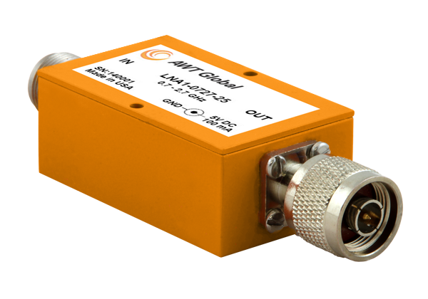
AWT Global has launched a new product line of low noise amplifiers: the LNA1 Series.
The new compact Low Noise Amplifiers (LNAs) are suited as RF measurement amplifiers and for signal boosting applications. LNA1 amplifiers cover telecommunications frequency bands from 700 to 2700 MHz. High gain of 25dB (+/-3) makes them perfect for applications like interference hunting.
“Due to its small form factor, LNA1 is well suited for mobile applications,” said Wolfgang Damm, president of AWT Global. ”LNA1 has been designed with power requirements of 5V/100mA, so it can be supplied by any USB port, standard at most portable instruments like spectrum analyzers.”
LNA1-0727-25 covers a frequency range of 700 to 2700 MHz. Impedance is 50 Ohms and VSWR ratio is 2.2:1. LNA1 features 25 dB (+/-3) of gain and 2.0 dB NF. Size is: 1.5” x 1.0“ x 2.5” ( 38 x 25 x 64 mm). Both, input and output comes standard with N-Type connectors, INP N(f) / OUT N(m). Other connector types are available on request. Power is supplied with a common 5.5 OD, 2.1 ID connector. AWT Global’s LNA1-0727-25 LNAs are available for sales immediately.
Apple is working on its own autonomous car, according to Reuters. An auto industry source told Reuters that the tech giant is gathering information and parts to make a prototype for the autonomous electric vehicle — the entire car, not just automotive software or components.
“They don’t appear to want a lot of help from carmakers,” said the unnamed source.
Apple is gathering advice on parts and production methods, focusing on electric and connected-car technologies, while studying the potential for automated driving, the source told Reuters.
“Fully automated driving is an evolution. Carmakers will slowly build the market for autonomous cars by first releasing connected and partially automated cars,” the source said. “Apple is interested in all the potential ways you can evolve the car; that includes autonomous driving.”
Meanwhile, Sony is also turning to autonomous vehicles, according to USA Today. The electronics giant is teaming up with Japanese robotics company ZMP to develop self-driving automobiles, reports the Financial Times. Sony invested 100 million yen (about $842,000) in ZMP.
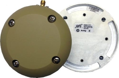
GPS Source has released a new GNSS antenna that is robust, lightweight, and suitable for harsh environments. It is designed for long-term, high-precision applications worldwide, the company said.
The antenna was engineered for the demanding aviation environment, in both commercial and military applications. Built to military standards (MIL-STD), it is impact resistant, tolerant of exposure to dust, chemicals and jet fuels, and has the ability to withstand shock and vibration.
Signal reception is unaffected by antenna placement. Designed to operate in the most extreme and demanding applications, it gives outstanding results, enabling maximum satellite reception, with ultra-low Dilution of Precision (DOP), GPS Source said.
“We are very excited about the new GNSS antenna,” said Robert Horton, CEO of GPS Source. “Our advanced technology provides superior performance in both GPS L1/L2 and GLONASS L1/L2. This is the best solution for technically demanding users.”
The antenna is available in multiple colors and with multiple connector options.
Fugro has launched the G4 service, designed to provide GNSS augmentation for offshore positioning applications. The new satellite correction service takes advantage of all four GNSS: GPS, GLONASS, BeiDou and Galileo.
By using all available GNSS satellites, Fugro’s G4 service is designed to improve availability and reliability of offshore positioning and thus enhance the safety and productivity of a wide range of survey and other activities offshore. G4 represents a significant advancement compared to augmentation systems which are based on GPS-only or GPS + GLONASS, the company said.
The BeiDou system operated by China currently provides coverage in the Asia-Pacific region. Fugro’s G4 service already utilises the first BeiDou satellites and is ready to start using the Galileo satellites as soon the EU announces Initial Operational Capability (IOC) status for this system. Galileo and future BeiDou satellites will be automatically included as they come online, steadily increasing availability and robustness of the integrated augmentation service.
The new G4 service will be particularly beneficial when the line-of-sight to certain satellites is obstructed by offshore structures – a key consideration during critical positioning operations. The G4 augmentation signals, transmitted via seven high–powered communication satellites to provide at least two independent broadcast channels anywhere in the world, will offer Fugro’s customers unrivalled coverage and availability.
An interactive map allows residents of New York to see what bacteria was mapped at their neighborhoods subway stops. (Image: Wall Street Journal)
A Big Data project in New York last summer set out to map germs on the city subway system, reports the Wall Street Journal. The scientists, from Weill Cornell Medical College, identified hundreds of types of bacteria in the transit system as a way to study the microbiology of urban environments.
In the 18-month study, researchers found germs that can cause bubonic plague uptown, meningitis in midtown, stomach trouble in the financial district and antibiotic-resistant infections throughout the boroughs, the WSJ writes. The team also found bacteria that keep the city livable, by sopping up hazardous chemicals or digesting toxic waste. They even tracked the trail of bacteria associated with cheese and sausage, popular snack foods among commuters.
The study is the first genetic profile of a metropolitan transit system. Microbiologists hope to discover new ways to track disease outbreaks, detect bioterrorism attacks, and combat the antibiotic resistance among microbes, which causes about 1.7 million hospital infections every year. Similar projects are taking place in Oregon (classrooms), Virginia (plumbing in buildings), and Chicago (hospitals).
The research team gathered DNA from turnstiles, ticket kiosks, railings and benches, then sequenced the genetic material and sorted it by supercomputer. They compared the results to databases of known bacteria, viruses and other life-forms. The findings uncovered how commuters seed the city subways every day with bacteria from the food they eat, the pets or plants they keep, and their shoes, trash, sneezes and unwashed hands. The team detected signs of 15,152 types of life-forms.
An online database at the Wall Street Journal allows residents to see what microbes were found at the stations they frequent.
PDF3D has improved the quality of tools and has introduced new features in version 2.11.0 of its 3D PDF software suite. The suite includes ReportGen, SDK Developer Toolkit and XML Server.
The company said in a news release that in response to customers, a large number of technical issues have been addressed.
“For our geospatial customers, we’ve extended the Geospatial 3D PDF solution profile with new input data formats, new processing methods and new library features for developers,” said Ian Curington, head developer at PDF3D. “And for engineers and CAD users, we’ve added new engineering representations and advanced texture mapping surface material characteristics.”
The release features new textures, material characteristics and templates available within the software.
“Those working with 3D terrain, point cloud data and scans will find various new formats and functions, including the addition of GeoTIFF 16 and 32-bit Raster Elevation Data and IMAGINE IMG Raster Data Format for multi-channel imagery and elevations,” said Curington. “With IRAP Classic Grid Formats, Landmark ZMap Elevation Grids and layered 2D PDF Geospatial map drawing now extended, there are some great new visual features in the tool.”
Version 2.11.0 is available to download immediately.