Two new apps developed at Texas A&M University-Corpus Christi use social media to help police officers, news stations, and the public navigate the many incidents and minor emergencies that may occur on a daily basis.
Richard Smith, creator of the two emergency response apps, is collaborating with Michelle Maresh-Fuehrer, assistant professor of Communication at A&M-Corpus Christi, to identify how the apps could aid first responders during emergencies.
“With the combination of SituMap and PhotoSorter, the public can be encouraged to submit photos and videos that may be helpful during an investigation,” said Smith, assistant professor of Geographic Information Science and Geospatial Surveying Engineering at the Island University. “For example, during an active shooter event, photos and videos of the suspect or their location can be taken with a cell phone and easily sent to responders. This could drastically improve response time and ultimately save lives.”
Photo credit: Texas A&M
Smith developed the mapping applications to provide a way for first responders to rapidly, and easily, receive and map information so they could have a more comprehensive awareness of emergency situations. Maresh-Fuehrer is working on extending the use of Smith’s social media mapping applications to enhance communication before, during, and after a crisis.
“A crisis event is typically a time of high stress and increased uncertainty for organizations and responders,” said Maresh-Fuehrer, who studies crisis communication strategies. “The applications developed by Dr. Smith have several features that allow for more informed and efficient crisis response.”
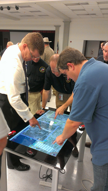
SituMap acts as a tablet-like digital command center that shows officers maps of the crisis area. With the touch of a finger the table-size display can be zoomed, rotated and drawn on. Like a personalized version of Google Maps, officers can search for locations and measure distances. But it goes further than Google Maps. A pin can be created in the application that could represent a person, police car, or groups of people. The pin can be strategically positioned around the area and directions can then be relayed to officers at the emergency location.
“An organization’s crisis team, along with emergency responders, can use SituMap to identify where people should be during a specific crisis,” said Maresh-Fuehrer. “With this application, responders can even view floor plans. This could help to identify safe locations such as fire exits and stairwells.”
PhotoSorter works in tandem with SituMap by allowing emergency responders, crisis planners and community members to share pictures or video of the crisis. Emergency responders can then upload the photos and video into SituMap to help in important decision-making situations.
SituMap and PhotoSorter were designed and developed at the Island University by Smith. The University Police Department is currently using a beta version of SituMap in training sessions.
In today’s digital world, people all over the globe can be connected through social media and, with the touch of a button, information about a major accident can be shared worldwide. With SituMap, important responders, as well as the community, can see real-time information on traffic congestion, roadblocks, and closed roads, which will aid in faster response times. The app also has a weather feature built into it which could be used during severe weather events such as a hurricane.
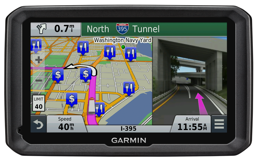
Lawyers for 11 Pennsylvania residents injured in 2013 when their charter bus slammed into an overpass in Boston, Mass., are suing GPS device manufacturers TomTom and Garmin, seeking more than $15 million in damages.
The bus driver was using both a Garmin and a TomTom satnav, neither of which were intended for use by commercial vehicles, but the lawsuit filed in January claims that the GPS units were at fault for not providing road height restrictions.
The bus driver, Samuel J. Jackson, told police he drove the 11-foot-high bus onto Soldiers Field Road, which is off-limits to vehicles more than 10 feet high, because he was “following the GPS.” At least one sign warning of this restriction was missing or damaged, and construction on the Harvard Street overpass obstructed other warning signs, the suit said.
Passengers were injured when the bus roof crushed backwards in the crash dropping the luggage rack and television onto the heads of the passengers, the Boston Globe reports.
Both TomTom and Garmin manufacture GPS units for professional drivers which feature information on bridge underpass height restrictions.
The new RX520 dual-frequency GNSS receiver from TeeJet Technologies brings reliable, upgradable accuracy and performance to precision farming applications, TeeJet said. It features an integrated L1/L2 GPS+GLONASS receiver and antenna in a single compact enclosure. Integral magnetic mounting allows for a clean, low-profile installation.
All RX520 receivers include ClearPath technology, which ensures smooth, consistent position data even if brief signal losses occur. The standard L1/L2 SBAS receiver offers +/- 5-8 in pass-to-pass accuracy for a wide variety of field operations. Optional precise point positioning (PPP) provides improved +/- 2-4 in pass-to-pass accuracy and year-to-year repeatability, making it suitable for strip-till and other high-precision operations. PPP accuracy is delivered via TerraStar subscription signal and is offered in 1-, 3-, 6- and 12-month packages.
“This is a very versatile receiver that is compatible with TeeJet and many third-party guidance and auto steer products,” said Tim Stuenkel, global marketing manager with TeeJet Technologies. “Another great feature is the ability to pay for only the accuracy you need today, with the flexibility to upgrade to higher performance down the road as your needs change.”
TeeJet Technologies manufactures a comprehensive line of products including agricultural spray nozzles for various pesticide/fertilizer applications, boom components, valves/manifolds, strainers, and spray guns, as well as GPS guidance systems, sprayer control systems, ISOBUS job computers, assisted steering systems and other precision farming products. In addition, TeeJet Technologies continues to invest in research and development to advance precision application and control technology.
The long-anticipated 2016 President’s Budget (PB) was submitted to Congress in early February. The PB is the spark that ignites the lengthy and often contentious congressional budget process, including: adopting a budget resolution framework, developing numerous discretionary spending bills, reconciling legislation between the House and Senate, approving continuing resolution stop-gap measures and finally, hopefully, appropriating funds for various programs — including the Global Positioning System (GPS) as part of the Department of Defense’s (DoD’s) U.S. Air Force (USAF) budget request.
For FY (Fiscal Year 1 Oct – 30 Sep) 2016, the U.S. Air Force requested a topline budget of $122.2 billion in Air Force controlled funding that exceeds funding levels recommended by the OMB (Office of Management and Budget) and laid out in the Budget Control Act by almost $10 billion. Several well-meaning friends still in high places in the government immediately sent me copies of the USAF budget while it was still warm, so to speak, and thought that I would be “properly incensed” — proffered one old friend — over the so-called $10B overdraft. I hate to disappoint my friends, but in the spirit of the USAF policy of putting the Bottom Line Up Front, I applaud the Air Force action and personally think it may be too little, too late. The supplemental request or overdraft should probably have been more on the order of $20B, not $10B.
Hollow Force
This is not an emotional reaction, but a reasoned statement by a seasoned veteran airman of 30 years in the USAF, yours truly, who served through at least two periods of a “hollow force” that were devastating not only to the USAF as an institution, but to the DoD as a whole and to all the personnel who served during these austere and dangerous times. And, yes, I am equating a hollow force with a dangerous force. Indeed, the term “hollow force” officially refers to military and government forces that certainly, on the surface, appear to be “mission ready,” but upon close examination suffer from moderate to severe shortages of personnel and equipment as well as deficiencies, to varying degrees, in training.
Gen Mark A Welsh III, Chief of Staff, USAF, testifying before the Senate Armed Services Committee 201 (Photo courtesy of USAF – SSG Sean K. Harp).
In recent testimony before the Senate Armed Services Committee, along with his fellow service chiefs, General Mark A. Welsh III, chief of staff of the United States Air Force, laid out the dangers inherent in the hollow force when he stated:
“Last year, our readiness levels reached an all-time low. As we struggle to recover, we don’t have enough units ready to respond immediately to a major contingency, and we’re not always able to provide fully mission-ready units to meet our combatant commanders’ routine rotational requirements.
“The Air Force’s modernization forecasts also are bleak. About 20 percent of [our] aircraft flying today were built in the 1950s and 1960s, and more than half of the rest are 25 years old or older.
“And now, due to sequestration, we’ve cut about 50 percent of our currently planned modernization programs.”
To someone who lived through the hollow force in the past, this is a scary description and prospect for our airmen. In describing the results of budget cuts and difficult decisions regarding program terminations that result in a hollow force, General Welsh put it this way:
“Without these tough calls, the Air Force ‘will be neither ready to fight today, nor viable against the threats of tomorrow’.”
Indeed, a hollow force puts every ones lives in danger. During the post-Vietnam hollow force created by the peanut farmer, there were times when there were B52 aircraft sitting alert just for the spy satellite photo ops that did not have engines in the nacelles nor certified crews to fly them. Aircrews were lucky if they were able to fly four hours per month, and believe me, that made us all less than proficient. I remember one incident specifically. My oxygen (O2) mask had failed on a previous flight and I needed a new one. In the high-performance aircraft in which we flew, regulations required an O2 mask be attached to our helmet and actually in place with crewmembers in the cockpit breathing pure (100%) O2 above a certain altitude. Because of budget cuts, I was issued a waiver, a piece of paper that said I was legal to fly without a fully functioning O2 mask. Fortunately I never was forced to fly without a fully functioning O2 mask, but what if I had been? What if I had passed out from O2 deprivation? What about the other members of the crew? What purpose did the piece of paper serve, other than mollifying a paper pusher’s conscience? Would the Air Force crash investigators have found it in the wreckage and said, “Oh, it’s OK, he had a waiver!” These are the types of things that can happen with a “hollow force.” We don’t need to go there again, and if nothing else, the extra $10B may be just the ticket to keep the aircrews proficient and equipment maintained.
The Color of Money
I know that budgeting and spending other people’s money seems like a simple issue, but with the government, nothing is ever simple. Consequently, the DoD has established an entire university system, known as the Defense Acquisition University (DAU), to train acquisition, program and financial officials in handling government acquisition funds, along with other procurement activities. Under the Budget Control Act guidelines and the Congressional cost-cutting exercise known as Seques-castration, 2016 is another cost-cutting year. That is significant when you understand that the USAF and all of DoD are still reeling from more than ten years of war, on more than one front, along with previously mandated significant budget and manpower cuts that seriously impacted the ability of the USAF to accomplish its multitude of missions.
Consider that budget cuts have a lingering, insidious and costly effect in equipment not maintained or replaced, training not accomplished, R&D not conducted, new technologies not developed, and inevitably the inability to accomplish the mission. A lot of the complexity in these budget-cutting moves relates to what the government refers to as the color of money. For example budgetary funds are appropriated and obligated for the USAF, and most other services, according to the following formula:
O&M – Operations and Maintenance – Obligated for 1 year
MILPERS – Military Personnel – Obligated for 1 year
RDT&E – Res Dev Test & Eval – Obligated for 2 years
PROC – Procurement – Obligated for 3 years
MILCON – Military Construction – Obligated for 5 years
As you can see, all funds are not obligated for just one year and then the money expires. Indeed, there are several colors of money, and failing to fund an RDT&E effort can have catastrophic results on the future of that program and associated programs that might benefit from the technology not developed. At any one time, the USAF is juggling budgets stretching across years and programs and moving money or robbing Peter to pay Paul.
FM (Financial Management) or financial and program management gurus at any one time are managing funds that originated as many as five years previously, plus the current year’s budget, while planning on how to use funds that might carry over to next year. They have just submitted the FY16 budget, which also means they are now hard at work on the FY17 budget without knowing what will be obligated for FY16. Across all those budget years, they have to deal with the arcane rules concerning the color of money. Yes, they are professionals (I’ve been married to one of the best for 35+ years), and they do a great job, but face it — sometimes they are just taking a well-educated guess and hoping for supplemental funding just to meet basic requirements.
Seriously, FM’ers live for the fairytale that one day a combatant commander will say, “Hey, your mission is more important than mine, so I will ‘MIPR’ (a one-time financial move) my funding to your budget line for your project.” Let’s see — a pig is not aerodynamically designed to fly…
Space
Funding for all space programs is especially critical, as the entire space arena is known as a force multiplier, in that satellites and space platforms provide and enable capabilities that increase the effectiveness and reach of all military and government personnel. Therefore, when space programs are not funded, delayed or are cut, the impact ripples across the entire DOD. This is especially true of GPS and PNT (Position, Navigation and Timing) systems which have become so ubiquitous, they are considered a must-have utility for billions of users around the globe, not just the U.S. government. In fact, military and government users may be the smallest segment of users for GPS and PNT services today, which is ironic when you consider that, as General John Hyten (USAF), commander of Air Force Space Command, loves to remind us, “GPS is provided to the world, and over three billion plus users, free of charge 24/7, by the United States Air Force.”
OCX – Next-Generation Space Control Segment
Unfortunately, a couple of major GPS-related programs are in trouble. For OCX, the Next-Generation Control Segment for GPS, my sources tell me, and 2016 budget documents clearly show, that current costs attributable to the prime contractor greatly exceed the contract award specification of ~$886M by a factor of 100% ,with a delivery date still far out on the horizon — somewhere around 2020 with a total program costs of $3.6B. That’s the bad news; the good news is there are definitely sound alternatives, and my sources tell me they are being belatedly explored.
Sometimes the behemoth primes are just that: too big and too expensive. Oftentimes the real subject matter experts (SMEs) reside in the smaller, boutique, more agile companies that can do the job in 24 months for $200M, which is a price that was quoted to me recently by a company with skin in the game, since their software products are responsible for launching and controlling all of the GPS satellites launched in the last eight years without a single failure. Plus, sources inside the company tell me that they have already developed a complete launch and initial checkout system for GPS III, which the OCX prime contractor is still struggling to construct.
This is where the USAF and OSD must step back and assess the OCX program for all its merits versus costs. GPS is not that complicated a satellite system, and yet we are on course to spend $3.6B for a ground C2 (Command and Control) system that will still have significant shortcomings. If it were the perfect C2 system in the end, that would be one consideration, but in fact, as the prime has admitted, it will be far from what was initially envisioned, and the total program costs will have grown by almost 400%.
This scenario begs the question: As the GPS acquisition authority, which product would you trust, a known product derived from a proven government and commercial satellite launch and C2 capability in operation today from a reliable company that has a flawless track record of GPS launches for the last eight years? Or a brand-new unproven product costing billions of dollars from a company that is clearly struggling technically and financially and has, at the end of the day, never launched or controlled a single GPS satellite? The answer seems clear to me. Obviously, there are valid alternatives, and in this budget environment the USAF needs to take a look at replacements, alternatives, supplements and backups, however you choose to phrase it, to OCX.
As we were going to press, we learned that Mr. Kendall has given the OCX Program a green light, but with several caveats indicating the program will be closely watched in the future. Mr. Kendall confirmed that while the OCX costs had indeed doubled, he was going to stay the course for now.
Major General Roger Teague, director of space programs for the Air Force acquisition chief, said a review by chief arms buyer Frank Kendall went well, but program officials and the contractor got “tough marching orders” to stick to schedule and cost targets. That is well and good, but history shows us that it has never happened in the past with the OCX program, and so some tough changes are going to have to be made if they are going to stay on track. We wish them well.
GPS III – Next Generation Space Segment
On the satellite or hardware side of the house, the GPS III — or next-generation GPS satellite — is also having problems, but in this case it centers on development and delivery issues with a subcontractor having serious technical issues and who has failed to deliver on cost or schedule. That subcontractor was just last week bought by a bigger prime, so we will have to wait and see what happens. In this case, however, the whole satellite program is not failing just a component, albeit an important one, the Mission Data Unit or MDU. Although again the answer seems simple, there are bigger forces at play, and one of them is wrapped up in a new government initiative known as Better Buying Power 3.0.
Better Buying Power 3.0
The current GPS III+ budget input states: “In an effort to implement Better Buying Power 3.0 (BBP 3.0) to control production costs, the [U.S.] Air Force intends to create a competitive environment. Options for the GPS III competition continue to be explored by USD (AT&L) [Under Secretary of Defense for Acquisition, Technology and Logistics], Mr. Frank Kendall.
Frank Kendall, under secretary of Defense for Acquisition, Technology and Logistics; the Under Secretary flag.
The Under Secretary of Defense for Acquisition, Technology and Logistics, or USD (AT&L), is a senior civilian official in the Office of the Secretary of Defense within the Department of Defense. USD (AT&L) is the principal staff assistant and advisor to the Secretary of Defense and the Deputy Secretary of Defense for all matters concerning departmental acquisitions and the general management of the department as a whole, which means he is a significant decision-maker where DoD acquisitions are concerned, and he has something to say about the plans for those acquisitions. Obviously, those plans need to make sense, financially, operationally and hopefully logically. Mr. Kendall, who has been in his current position for almost four years, has brought a much needed common-sense approach to government acquisition, and we can only hope he continues to make judicious, practical and logical decisions.
For GPS III+, the U.S. Air Force’s published notional plan is for a two-phased competition process. Phase one is a Production Readiness competition for up to three firm-fixed price contracts to mature competitors’ production designs for a competition in Phase two. Phase two will be a full and open competition for up to 22 GPS III Production SVs [satellite vehicles] with an expected award in FY17/18. The [U.S.] Air Force GPS Directorate received USD (AT&L) approval to purchase GPS III SV09-10 from the incumbent Lockheed Martin (LMCO) at the December 2014 Defense Acquisition Board (DAB), in order to sustain the GPS constellation while competitive options are pursued.” [Bold added for emphasis.] See the budget document here.
The “government speak” sounds great if you need an entirely new GPS III system, which consists of, at a minimum, a new payload, satellite, launcher and ground C2 system (remember OCX is only designed to work with current and planned GPS SVs, and it doesn’t even do that today). But, in fact, the U.S. government only needs an MDU, which is a critical part of the payload. Indeed, failure to produce the MDU on time has delayed the entire GPS III program by about 18 months to date.
Even more troubling to me is the seemingly innocuous phrases from the government plan that states “create a competitive environment…firm-fixed price contracts to mature [up to three] competitors’ production designs,” which is nothing more than government speak for “We are going to pay competitors to mature their technology so they can compete against the current prime (LMCO), who is currently building the first 10 GPS III satellites.” In effect, the government is saying the competitors on their own cannot compete against LMCO so we, the government, are going to give them contracts and lots of money to help them get to a point where they can compete, and then we are going to have a recompetition. Of course, this is going to take at least three years and cost hundreds of millions of dollars, and LMCO may well win again in the end, but at least we will have conducted a competition. Does this approach make sense? Does it pass the financial, operational, and logic tests? Does it pass the Washington Post test? I guess we will have to wait and see if Frank Kendall agrees.
BBP 3.0
So, what exactly is the initiative known as Better Buying Power 3.0? It’s DoD’s mandate to “do more with less”:
“DoD’s Mandate To Do More Without More
“Better Buying Power (BBP) is the implementation of best practices to hopefully strengthen the Defense Department’s buying power, improve industry productivity, and provide an affordable, value-added military capability for the warfighter and government user. Launched in 2010, BBP encompasses a set of fundamental acquisition principles to achieve greater efficiencies through affordability, cost control, elimination of unproductive processes and bureaucracy, and promotion of competition. BBP initiatives also incentivize productivity and innovation in industry and Government, and improve tradecraft in the acquisition of services.”
Sounds great, doesn’t it? Now for the rest of the story.
We can all agree that defense budgets are tight, so it will be interesting to see how BBP 3.0 plays out in the arena for GPS SVs. Will the U.S. Air Force initiate a competition to acquire an entirely new GPS III SV, or fix the problem with the current GPS III program, the MDU? Recall my previous column concerning the GPS III Sources Sought, in which the GPS III MDU was compared to an aircraft engine and the GPS III satellite was compared to an aircraft. In this analogy, the Air Force didn’t ask for companies/competitors to produce a new aircraft just because it needed an alternate engine. It simply contracted for another engine supplier — the most cost-effective competition that adheres to the principles of BBP 3.0. However, from the GPS Directorate budget language quoted earlier, it appears as if the Air Force is looking to pursue an entirely new GPS III system to include SVs, rather than just procure an alternate MDU.
In my humble opinion, stringently applying BBP 3.0 to GPS III issues means simply to employ competition at the correct level (i.e., for the engine rather than the entire aircraft). An interesting feature and significant added cost to the GPS budget, which I briefly mentioned earlier, concerns the need for a new ground C2 system if the total new systems approach is taken. For, indeed, if preliminary elements of the GPS space segment are developed without cross-checking the impact to the GPS control segment, the technical, operational, budgetary and schedule impacts will be significant. For example, the already troubled next-generation GPS ground control system, OCX, budget likely has not considered the integration costs of a newly developed, yet-to-be-procured “production ready” GPS III+ SV. Indeed, OCX today is geared for the GPS III already contracted for and it is failing to meet that challenge in a spectacular and expensive way. So it is possible, even probable, that OCX integration costs for yet another new model of GPS III family of satellites would increase the OCX budget significantly…unless of course one assumes that the U.S. Air Force acquires a perfectly matched, new GPS III satellite that integrates seamlessly with OCX. In other words, an entirely new GPS III SV would need to be perfectly matched to the current GPS III SV — and what are the chances of that, and why would you spend hundreds of millions of scarce acquisition dollars to procure an exact and more expensive replica?
Budget constraints are tight and getting tighter. BBP 3.0 mandates the Air Force “do more with less” in every context. For GPS III SVs, this means developing an alternate MDU rather than buying a new block of GPS SVs.
Until next time, Happy Navigating, and remember: GPS is brought to you free of charge by the United States Air Force.
Three telecommunications companies are joining together to fight patent-infringement claims involving the use of assisted GPS in their mobile networks, reports ZDNET.
Telstra and Optus are Australian telecommunications and media companies, and Vodafone is based in the United Kingdom.
The claim by Australian company Voxson alleges that the mobile network operators are infringing on two patents held by Voxson since the 1990s. One patent, Vox 1, deals with how customers’ mobile phones are tracked on mobile networks, and forms the basis for the assisted GPS used by the networks to deliver location information to their customers. The other patent, Vox 2, deals with video streaming.
The lawsuit was brought against the three companies in 2013, and the allegations cover the 2G, 3G, and 4G networks of all three carriers.
Trimble has introduced the R1 GNSS receiver, a pocket-sized, rugged, standalone receiver that works with iOS, Android or Window mobile handhelds, smartphones and tablets using Bluetoothconnectivity. When paired with a smart device, the receiver adds professional-grade GNSS geo-location capabilities to transform consumer devices into high-accuracy mobile data collection systems.
With the evolution of smartphones and tablets, more field workers now have access to positioning technologies for geospatial data collection. The Trimble R1 GNSS receiver is designed to collect data and inspect or manage assets using smart devices without an integrated high-accuracy GNSS receiver. Adding the optional Trimble ViewPoint RTX correction service to the R1 receiver enables users to achieve reliable sub-meter accuracy, Trimble said.
The Trimble R1 receiver is compact and portable, weighing 6.5 ounces (187 grams). With an all-day battery life, the receiver can be carried in a vest pocket, attached to a belt using the optional belt pouch, or pole mounted. The receiver also integrates with Trimble TerraFlex, Trimble TerraSync and Trimble Positions mapping and Geographic Information System (GIS) field software.
“The addition of the R1 GNSS receiver expands our portfolio to address the needs of organizations that have adopted a workplace Bring Your Own Device (BYOD) strategy for their businesses. We are providing an innovative solution to enable next generation capabilities for a much broader base of field workers to collect high-accuracy geospatial data,” said Alain Samaha, business area director of GIS and Software for Trimble’s Geospatial Division. “Our focus is to provide customers with a variety of options and flexibility when it comes to mobile device deployment and authoritative data collection to increase productivity and improve operations.”
The Trimble R1 GNSS is a multi-constellation receiver that supports GPS, GLONASS, Galileo, BeiDou and QZSS satellite signals. The Trimble ViewPoint RTX corrections are delivered via cellular data network coverage or over satellite in remote locations — without the need for a traditional base station or VRS network — when using Trimble’s Mapping & GIS software or API. In addition, the R1 receiver can leverage SBAS and VRS correction sources to achieve sub-meter accuracy.
Trimble TerraFlex is a scalable cloud-based solution for geospatial data collection. TerraFlex addresses a wide variety of field requirements including attribute-rich GIS data collection on professional and consumer devices.
Art Kalinski, GeoIntelligence Insider editor, reports on Remote GeoSystems‘ geospatial DVR at the 2015 Esri Federal GIS Conference, held Feb. 9-10 in Washington, D.C. LineVision Esri ArcGIS is a stand-alone desktop software that leverages Esri GIS technology to map, analyze and package geospatial full motion video, photos, annotations, documents, SHP files and raster imagery from the geospatial DVR.
The ground control system (OCX) that Raytheon is developing for the next-generation GPS program has passed a Pentagon review, reports Reuters. The program will be monitored to ensure it stays on track, a senior Air Force official said on Feb. 6 as reported by the news service.
Major General Roger Teague, director of space programs for the Air Force acquisition chief, said a review by chief arms buyer Frank Kendall went well, but program officials and the contractor got “tough marching orders” to stick to schedule and cost targets.
Raytheon’s program manager Matt Gilligan said the review provided the company with “clear direction, the best technology, and appropriate resources to…deliver OCX on a schedule that meets GPS enterprise needs.”
Kendall had ordered the review after an Air Force restructuring that increased the cost of the program by 80 percent to $1.6 billion.
A new report by Beecham Research examines how the agricultural sector is embracing precision farming to face challenges raised by an increasing worldwide population and the impact of climate change.
The United Nations predicts the global population will reach 8 billion by 2025, and 9.6 billion by 2050, meaning food production must increase by 70 percent by 2050.
The report explores how agricultural operations are changing through the Internet of Things (IoT) and related smart and connected farms concepts, including precision agriculture guided by GPS. It provides a geographic analysis discussing public policies, adoption drivers and barriers, and opportunities for the M2M/IoT community.
The Executive Summary of the report, “Towards Smart Farming: Agriculture Embracing the IoT Vision,” is available here.
The Lehmann L-A 300 drone is designed for mapping.
Lehmann Aviation has rolled out a new version of its OperationCenter, a flight preparation and mission control software program for automatic orthomosaic flights. Also, the company dropped the price for its L-A 300 fully automatic professional drone designed for mapping, because of an uptick in demand and increased production.
The new version of Lehmann OpsCenter, designed for Windows 8.1 tablets and PCs, now includes:
New mission control functions (holding, auto return, non-flying zone)
Terrain awareness during mission preparation, for safer flights in mountain areas
Integration with Google Earth for flight preparation and replay
New easier upgrade and update procedures directly through the web
New options to manage new cameras (GoPro, Canon) for orthomosaics and surveying.
Priced at $2,890, the L-A 300 is a professional drone designed for accurate mapping and digital elevation models (DEMs) that works with the GoPro, Canon S110 and multispectral cameras. It flies automatically for 30 to 45 minutes at a trajectory pre-prepared by the user in the OpsCenter (the range is 18.5 miles).
“In 2014 we significantly increased our production volume thanks to numerous orders from all around the world,” said Benjamin Lehmann, founder and CEO of Lehmann Aviation. “This enabled us to reduce the price for our best-sellers, all L-A-series drones. We also made the decision to follow our strategy of offering really high-tech aerial solutions at fair prices.”
A U.S. judge dismissed the bulk of two lawsuits by LightSquared and equity owner Harbinger Capital Partners, reports Reuters. The suits accused Trimble, Garmin and Deere & Co. of misleading them about interference concerns and hastening the company’s fall into bankruptcy.
In an opinion issued Feb. 5 in Manhattan federal court, Judge Richard Berman threw out Harbinger’s lawsuit, and denied nine of 11 claims by LightSquared.
LightSquared has been in bankruptcy since 2012, when the Federal Communications Commission revoked its license to build a planned wireless network over concerns it could interfere with GPS.
The lawsuits alleged that Deere, Garmin International , Trimble Navigation Ltd, and a GPS industry group led LightSquared to believe the planned network would not pose an interference risk. It wasn’t until LightSquared had pumped $4 billion into the project, the plaintiffs argued, that the GPS industry voiced their concerns.
Judge Berman dismissed many claims from both plaintiffs, including breach of contract and civil conspiracy, leaving alive only LightSquared’s claims for negligent misrepresentation and constructive fraud.
Because the judge did not dismiss all claims, LightSquared could still be able to probe the GPS companies’ books and records during discovery.
Harris Corporation and Exelis Inc. today announced a definitive agreement under which Harris will acquire Exelis in a cash and stock transaction valued at $23.75 per share, or an approximately $4.75 billion enterprise value. The agreement has been unanimously approved by the boards of directors of both companies.
The transaction is expected to close in June 2015 and is subject to customary closing conditions, including regulatory and Exelis shareholder approval.
Exelis is a global aerospace, defense, information and services company with a 50-year legacy. It was previously under the ITT Corporation umbrella, but spun off in 2011. Headquartered in McLean, Va., Exelis employs about 10,000 people.
Exelis employs about 10,000 people. the combined Harris/Exelis company will have about 23,000 employees. including 9,000 engineers and scientists.
One of Exelis’ biggest product offerings in the past year has been its Signal Sentry 1000, which detects and locates sources of intentional and unintentional interference to GPS signals and provides users with actionable intelligence. Exelis navigation payloads and components have been on board every U.S. GPS satellite ever launched and have more than 700 years of accumulated on-orbit success.
Harris is an international communications and information technology company serving government and commercial markets in more than 125 countries. Headquartered in Melbourne, Fla., the company has about $5 billion of annual revenue and 13,000 employees. Harris is engaged in a five-year contract with Aireon LLC that will create the first global satellite-based aircraft tracking system. The company’s Automatic Dependent Surveillance-Broadcast (ADS-B) 1090 Extended Squitter receiver payload has been successfully tested and qualified for simulated operation in the harsh environment of space for more than 12 years.
Under the terms of the transaction, Exelis shareholders will receive $16.625 in cash and 0.1025 of a share of Harris common stock, based on Harris’ closing price as of Feb. 5, for each share of Exelis common stock. Upon closing, Harris shareholders will own approximately 85 percent of the combined company, and Exelis shareholders will own approximately 15 percent. On a pro forma basis for the latest 12 months ended Dec. 31, 2014, the combined company would have had more than $8 billion in revenue and about 23,000 employees globally, including 9,000 engineers and scientists.
“Acquiring Exelis is transformational for Harris,” said William M. Brown, chairman, president and chief executive officer of Harris. “The combination of the two companies’ highly complementary core franchises creates a competitively stronger company with significantly greater scale. We are expanding in a market, where we have decades of success and a workforce dedicated to providing our customers with innovative and cost-effective solutions for some of their most complex challenges.”
“This agreement to become part of Harris Corporation represents an exciting new chapter for Exelis,” said David F. Melcher, chief executive officer and president of Exelis. “Combining the companies not only creates shareholder value, but the commitment to excellence and innovation that both companies share will significantly benefit customers and provide new opportunities for employees.”
Melcher also noted, “Our 2014 was another strong year, and we expect to report revenue of approximately $3.25 billion and adjusted operating margin between 12.4 and 12.5 percent, which is in line with our previous guidance.” Exelis indicated that approximately $25 million of its anticipated free cash flow for 2014 shifted into 2015 due to some delayed collections, but that its estimate for 2015 free cash flow is being increased to approximately $275 million. Exelis also expects depreciation and amortization of approximately $106 million in 2014, net debt of $139 million and a net unfunded pension liability of approximately $1.9 billion at the end of 2014. Exelis ended the year with an estimated $2.8 billion in funded backlog.
Integration plan. Harris said it has developed a detailed execution plan to ensure seamless integration and achieve identified cost synergies. The dedicated integration team will have executive leadership and be comprised of senior members of both organizations. Harris is confident in its ability to effectively combine these two companies and provide the organizational alignment to achieve full strategic value, the company stated in a news release.
At the 2014 ION GNSS+ Conference Sept. 9-12 in Tampa, Fla., Lori Thompson of Exelis provided GPS World readers with updates about the company’s activities.