Category: Applications

  • Machine learning boosts GPS precision: New method enhances ambiguity resolution

    Machine learning boosts GPS precision: New method enhances ambiguity resolution

    High-precision GNSS applications, such as real-time displacement monitoring and vehicle navigation, rely heavily on resolving carrier-phase ambiguities. However, traditional methods like the R-ratio and W-ratio tests often use empirical thresholds, which can lead to unreliable results due to biases and environmental variability.

    These limitations hinder the efficiency of Precise Point Positioning Ambiguity Resolution (PPP-AR), especially in dynamic or challenging conditions. Based on these challenges, there is a pressing need to develop more robust and adaptive techniques for ambiguity validation.

    Published (DOI: 10.1186/s43020-025-00167-8) on June 9, 2025, in Satellite Navigation, researchers from the Royal Observatory of Belgium and the State Key Laboratory of Precision Geodesy in China unveiled a Support Vector Machine (SVM)-based method for GNSS ambiguity validation.

    The study leverages machine learning to combine multiple diagnostic metrics, achieving higher accuracy and reliability than conventional approaches. The model was trained on extensive datasets and validated through real-world experiments, showcasing its potential to transform high-precision positioning.

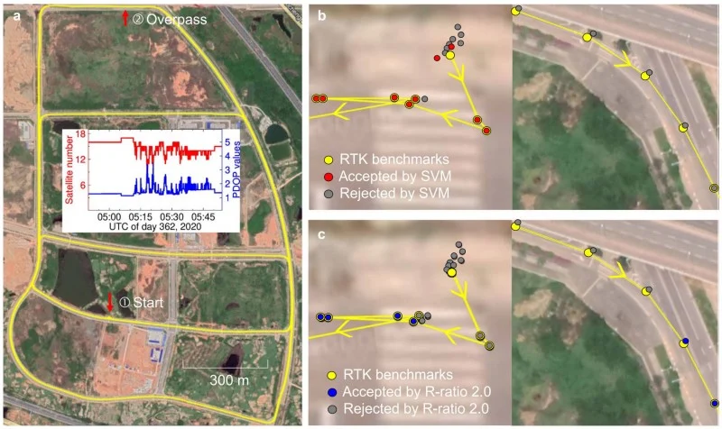
    The study’s key innovation lies in its integration of seven diagnostic metrics — including R-ratio, ADOP, and ambiguity dimension — into an SVM model. This approach addresses the limitations of traditional methods, which often rely on single thresholds and fail to account for complex dependencies among variables.

    The SVM model achieved an 92% success rate in ambiguity validation, outperforming the R-ratio test’s 82% in kinematic scenarios. Notably, the model reduced convergence time prediction errors to just 1.0 minute, compared to 5.0 minutes for conventional methods.

    Highlights of the research include:

    • Enhanced Reliability. The SVM model’s ability to adaptively weigh multiple metrics ensures more consistent ambiguity resolution.
    • Real-World Validation. A vehicle-borne experiment demonstrated a 92% success rate, proving the method’s practicality in dynamic environments.
    • Scalability. The framework is adaptable to both single- and multi-constellation GNSS systems, broadening its applicability.

    Despite its advancements, the study acknowledges a 5% error rate in unresolved ambiguities, pointing to future research directions, such as incorporating variance-covariance data for further refinement.

    “Our SVM model represents a paradigm shift in ambiguity validation,” emphasized Jianghui Geng, co-author of the study. “By harnessing machine learning, we’ve not only improved accuracy but also provided a scalable solution for diverse GNSS applications, from autonomous vehicles to geodetic monitoring.”

    The SVM-based method holds significant promise for industries requiring ultra-precise positioning, such as autonomous navigation, aerospace, and infrastructure monitoring. Its ability to shorten convergence times and enhance reliability could revolutionize real-time GNSS applications, particularly in urban or obstructed environments where signal interruptions are common.

    Future iterations of the model, incorporating additional data layers, could further bridge the gap between theoretical precision and real-world performance, setting a new standard for GNSS technology.

  • Trimble and TDK join forces to accelerate precision navigation

    Trimble and TDK join forces to accelerate precision navigation

    Trimble and InvenSense, a TDK group company, will work together to deliver an advanced navigation solution that combines the Trimble ProPoint Go engine and Trimble RTX correction service with TDK’s SmartAutomotive inertial measurement units (IMUs) module from InvenSense.

    The solution is expected to provide greater accuracy and reliability in positioning and navigation across various automotive and IoT applications.

    The Trimble ProPoint Go positioning engine is designed to deliver high-accuracy position and orientation data by utilizing internationally accessible Trimble correction services. With quad-frequency GNSS signal support and Trimble ProPoint Go’s first-in-market Automotive Safety Integrity Level-C (ASIL-C) certified correction data, this positioning ecosystem helps companies enhance their automated driving capabilities with a focus on safety. It also helps drive accuracy for IoT applications such as field robotics.

    TDK IMUs integrate a triaxal accelerometer and a triaxal gyroscope in a compact six-axis motion sensor to detect the linear acceleration and angular velocity of vehicles and objects with superior level of accuracy. With its proprietary six-axis and MEMS fabrication platform, TDK inertial sensors enhance applications possibilities thanks to their high-performance, small-size and low-power features.

    “Together with TDK we are bringing the power of high-accuracy and precise positioning along with state-of-the art ASIL-certified sensors to help our customers build innovative solutions for automotive and IoT markets,” said Olivier Casabianca, vice president, advanced positioning at Trimble. “As we continue to expand our positioning services with TDK and other tier one companies, we are powering the connected world while ensuring the safety and accuracy of connected systems.”

    Positioning Solutions Built for the Connected World
    Key benefits of the ProPoint Go positioning engine and RTX correction with TDK’s modules include:

    • Accuracy. The synergy between the two solutions delivers superior positioning accuracy under all conditions: open sky, urban canyons and indoor, even in harsh environments and among wide temperature variations.
    • Reliability. Customers can rely on consistent and dependable orientation and navigation data, crucial for applications such as autonomous vehicles, drones and industrial machinery.
    • Versatility. The integrated solution is adaptable to a wide range of applications, such as automotive positioning, advanced driver-assistance systems (ADAS), cellular vehicle-to-everything (C-V2X), field robotics and unmanned aerial vehicles (UAVs).

    “Inertial and positioning data have become critical in enabling automation, improving efficiency and monitoring conditions,” said Stefano Zanella, automotive motion VP and general manager, TDK. “Building on almost a decade of collaboration with Trimble, we are delighted to take our efforts to the next level: by offering an integrated solution, we empower customers to accelerate deployment, streamline integration and maximize the value of this transformative technology.”

    The TDK automotive safety IMU components, developed as SEooC according to ISO 26262, are suitable for applications with requirements up to ASIL-D. In addition to its six-axis solution, TDK provides quality-managed solutions that also include a three-axis magnetometer in a nine-axis solution.

  • Safran’s Skylight GNSS receiver enhances PNT resilience with Galileo PRS and M-code

    Safran’s Skylight GNSS receiver enhances PNT resilience with Galileo PRS and M-code

    Safran Electronics & Defense has launched Skylight, a multi-mode military GNSS receiver designed to withstand electronic warfare threats. The company unveiled the new receiver at the Paris Air Show, describing it as a compact and resilient GNSS solution with high integrity.

    Skylight is notable for being the first GNSS receiver to be flight-tested with compatibility for Galileo Public Regulated Service (PRS). Its performance was validated during flight trials aboard a combat aircraft. The receiver delivers encrypted, spoofing-resistant PRS signals, designed to enhance security for operations in contested environments.

    The device is also compatible with M-code, ensuring interoperability with U.S. and allied military systems. Additionally, Skylight features a certified civil GPS channel, enabling navigation in civil airspace when necessary. According to Safran, this feature eliminates the need for a separate civil GPS receiver, resulting in weight and cost savings for platform integrators.

    Skyligh also incorporates advanced anti-jamming and anti-spoofing algorithms that have been proven through more than 16,000 operational cases. The receiver is designed to operate with anti-jamming antennas and is fully compatible with the SkyNaute inertial navigation system, allowing for integration into resilient positioning, navigation and timing (PNT) architectures.

    Alexandre Ziegler, executive vice president for the Defense Global Business Unit at Safran Electronics & Defense, said the company already counts two leading aerospace manufacturers among the first adopters of Skylight, including Airbus Helicopters, which has selected the H225M platform to be equipped with the receiver.

    “In an era where PNT resilience is critical, Skylight delivers agility, precision and reliability with a standalone, multi-constellation GNSS receiver whose robustness is strengthened by our expertise in defensive Navwar,” Ziegler said.

  • Safran Electronics & Defense debuts resilient PNT system

    Safran Electronics & Defense debuts resilient PNT system

    Safran Electronics & Defense has introduced BlackNaute, a new autonomous positioning, navigation and timing (PNT) system. The system integrates Safran’s HRG Dual Core inertial navigation technology, the Skylight multi-mode GNSS receiver board and an atomic clock to offer navigation resilience in challenging electronic warfare environments.

    BlackNaute’s built-in atomic clock is designed to maintain precise timing, which is essential for secure communications and collaborative combat operations. The system features advanced anti-jamming and anti-spoofing algorithms, which have been validated in more than 16,000 operational cases. These capabilities allow BlackNaute to detect compromised signals and automatically switch to autonomous and trusted navigation and timing sources to ensure continuity of operations.

    Its modular design allows it to be adapted across a variety of platforms. Airbus Helicopters has selected the NH90 to be equipped with this new Embedded GNSS and Time INS (EGTI).

    “What we are offering today is not just a new solution — it’s an operational guarantee, designed to meet the challenges of electromagnetic warfare,” said Alexandre Ziegler, Executive Vice President, Defense Global Business Unit at Safran Electronics & Defense. “It is a concentration of innovation combining precision, versatility, and security to ensure positioning, navigation and timing — anywhere, under any circumstances.”

  • The rise of precision timing for aerospace and defense applications

    The rise of precision timing for aerospace and defense applications

    In the mission-critical world of aerospace and defense, where reliability and resilience can mean the difference between success and failure, precision timing is an essential technology for increasingly sophisticated and connected systems. Every nanosecond matters, whether ensuring UAVs operate safely or enabling secure real-time communication in high-threat environments. At the heart of these systems is precision timing technology, which ensures precise synchronization within and between systems, enabling high data throughput with minimal latency.

    Aerospace and defense systems operate in some of the harshest environments on the planet, where extreme temperatures, shock and vibration and electromagnetic interference (EMI) are commonplace. While quartz technology has historically been used to deliver timing references in aerospace and defense applications, precision timing based on microelectromechanical systems (MEMS) technology has recently proven to be a superior alternative due to its better performance, resilience and reliability.

    To understand the key differences between MEMS and quartz technologies for timing devices used in aerospace and defense applications, let’s focus on size, weight and power consumption (SWaP), as well as the ability of these two distinct types of timing technologies to perform reliably and accurately in harsh, demanding operating environments.

    The Rise of MEMS Oscillators in Aerospace and Defense

    MEMS-based precision timing technology is proven and highly reliable, designed to perform reliably in the harsh environments in which aerospace and defense applications operate. Unlike quartz timing devices, MEMS-based timing devices such as resonators, oscillators and clock generators are manufactured using semiconductor processes. This silicon MEMS technology enables unparalleled miniaturization, better resilience, and higher performance across a variety of environmental conditions. By encapsulating a MEMS resonator in a vacuum-sealed cavity, these timing devices are protected from contamination, aging, and environmental disruptions such as shock and vibration.

    SiTime, a leader in MEMS-based precision timing technology, has developed a variety of MEMS-based oscillators and clocks that outperform quartz counterparts in key areas like stability, ruggedness, and SWaP. (See Figure 1.) These include popular devices such as temperature-compensated oscillators (TCXOs) and oven-controlled oscillators (OCXOs). The company’s MEMS-based Endura family of ruggedized Super-TCXOs and OCXOs, for example, is specifically designed for demanding aerospace and defense applications.

    Figure 1. MEMS OCXOs surpass vibration-rated quartz OCXOs in performance, offering superior functionality with reduced SWaP. (Credit: all photos and tables provided by author)
    Figure 1. MEMS OCXOs surpass vibration-rated quartz OCXOs in performance, offering superior functionality with reduced SWaP. (Credit: all photos and tables provided by author)

    Key Advantages of MEMS Precision Timing Devices

    • Low Phase Noise: MEMS Super-TCXOs deliver ultra-low phase noise, even in the presence of environmental stressors such as shock, vibration, and rapid temperature changes, which is essential for high-frequency RF systems such as tactical radios and satellite communication terminals. With low phase noise at 10 MHz output frequency of -165 dBc/Hz at 10 kHz offset and -175 dBc/Hz noise floor, these MEMS oscillators outperform typical quartz-based devices, ensuring cleaner signal transmission and better system performance.
    • Shock and Vibration Resistance: MEMS oscillators are qualified by SiTime to the highest MIL-STD-883 shock stress level of 30,000 g and customers have reported they can operate at 100,000 g shock levels. This extreme shock resistance in conjunction with ultra-low acceleration sensitivity, as low as 0.009 ppb/g total gamma, make them ideal for rugged environments including space missions, aircraft and military vehicles. In contrast, quartz oscillators are prone to failure or frequency jumps under similar conditions.
    • Temperature Stability: Super-TCXOs exhibit excellent temperature stability, with frequency stability of ±10 ppb across a temperature range of -40 °C to +105 °C. This stability is critical for aerospace and defense applications subject to rapid temperature changes, which cause traditional quartz oscillators to fail or experience frequency jumps. (See Figure 2.)
    • SWaP Efficiency: MEMS oscillators are significantly smaller, lighter, and more power-efficient than quartz devices, meeting the stringent SWaP requirements of modern aerospace systems. For example, OCXO-grade TCXOs (Elite-X) come in a compact 7.0 x 5.0 mm2 surface-mount package and consume less than 115 mW of power while delivering ±5ppb frequency stability over temperature performance. This makes them ideal for space-constrained, low-power applications like small satellites (SmallSats) and tactical communication systems.
    • Reliability: MEMS oscillators offer superior long-term reliability, with a mean time between failures (MTBF) of more than 1 billion hours – about 30 times greater than quartz-based oscillators. Additionally, MEMS devices exhibit lower aging rates than quartz, ensuring consistent performance over extended missions.
    Figure 2. Endura Epoch OCXOs are unaffected by rapid temperature changes, as simulated by air flow that is turned on and off repeatedly.
    Figure 2. Endura Epoch OCXOs are unaffected by rapid temperature changes, as simulated by air flow that is turned on and off repeatedly.

    Real-World Applications of Precision Timing Technology

    • Tactical Radios: Precision Timing is critical for secure data transmission in military communication systems. Super-TCXOs, offering low phase noise and vibration resistance, ensure signal integrity even in the harshest battlefield conditions, improving the reliability of tactical radios used by defense forces.
    • Satellite Communication Systems: Reliability, component size and power efficiency are paramount in satellite communications. MEMS oscillators enable high-bandwidth data transmission with minimal signal degradation, and their robust design ensures uninterrupted performance during mission-critical operations. Their small size and energy efficiency also make them ideal for space- and power-constrained satellite systems.
    • UAVs: UAVs are often deployed in dynamic environments where they are exposed to extreme temperatures and vibrations. MEMS oscillators, with their superior shock and vibration resistance, are a preferred timing solution for maintaining stable navigation and communications, ensuring UAVs can carry out their missions without interruption.
    • Radar Systems: Advanced radar systems depend on precise timing to synchronize signal processing, reduce interference, and optimize target detection. MEMS-based Precision Timing devices, with their high vibration resistance and temperature stability, deliver reliable performance in high-intensity environments, such as on naval vessels or fighter jets, where traditional quartz oscillators may struggle to maintain accuracy.
    Photo: SiTime chart

    The Future of Precision Timing in Aerospace and Defense

    As aerospace and defense systems become more advanced, the need for reliable precision timing solutions will continue to grow. MEMS-based oscillators, with their superior SWaP efficiency, rugged design, and inherent reliability, represent the future of Precision Timing technology in these critical sectors.

    While quartz oscillators have served the aerospace and defense and industry for decades, MEMS technology is proving to be a more effective Precision Timing solution for next-generation systems. MEMS-based TCXOs and OCXOs are setting new benchmarks for Precision Timing, offering unmatched resilience, reliability, and performance in the most demanding environments.

  • Parrot shows off Anafi UKR micro UAV for defense at Paris Air Show

    Parrot shows off Anafi UKR micro UAV for defense at Paris Air Show

    Parrot has unveiled the Anafi UKR (Ukraine) range of compact defense micro-UAV drones at the Paris Air Show. The micro-UAVs are built to meet the critical demands of field operations, from defense theaters to public safety missions.

    Developed for defense forces operating in high-threat environments, AnafiUKR brings together embedded AI, optical navigation, and full offline autonomy in a sub-1 kg format. Building on this foundation, Anafi UKR GOV adapts the platform’s capabilities to the needs of law enforcement, first responders and government agencies, ensuring the same level of resilience, tactical awareness, hardened cyber-resilience, and total data sovereignty.

    “ANAFI UKR was born from the urgent need to defend a nation’s sovereignty and freedom. We’ve taken what we learned in high-intensity, GNSS-denied conflict zones, where drones are jammed, spoofed, and hunted, and turned it into a platform that public agencies can rely on. It’s the most advanced micro-UAV we’ve ever built: sovereign, powerful, and radically easy to use. When national security and civil protection overlap, as they increasingly do, agencies need tools that don’t compromise. ANAFI UKR is our response: the best of tactical autonomy, delivered in a micro-UAV that combines intuitive operation with advanced tactical capabilities.”

    Henri Seydoux, founder and CEO of Parrot

    Anafi UKR GOV is based on Parrot’s defense-grade micro-UAV deployed by several European, North American and NATO allied forces since mid-2024. Designed to remain fully operational in GNSS-denied environments and hostile electromagnetic conditions, the system integrates advanced optical navigation, anti-spoofing with frequency hopping military radio, and hardened cybersecurity architecture , all tested in live electronic warfare scenarios.

    Anafi UKR and Anafi UKR GOV are both in full production and commercially available. Deliveries are ongoing to defense and institutional clients, and the systems are now open to order for all eligible public safety agencies, law enforcement units, and government users worldwide.

  • Aquark, UK Royal Navy trial cold atom-based atomic clock

    Aquark, UK Royal Navy trial cold atom-based atomic clock

    Quantum sensing specialist Aquark Technologies has completed a second trial of its AQlock atomic clock system, facilitated by the Disruptive Capabilities and Technologies Office (DCTO) of the UK Royal Navy. The AQlock functioned continuously aboard HMS Pursuer in the Solent area over three days, what Aquark calls an important milestone for position, navigation and timing (PNT) technology and a step forward in the mission to reduce global reliance on GNSS.

    The Defence Science and Technology Laboratory supported the company’s latest trial, providing time and frequency test and evaluation expertise and equipment. It aims to improve conventional PNT by transferring the stability of atoms that have been cooled to near absolute zero to a conventional oscillator to reduce long-term drift. This makes the technology capable of maintaining high precision for longer, without the usual required correction from GNSS, augmenting existing timing capabilities. 

    The AQlock is an industrially designed and built cold atom-based atomic clock. The technology is underpinned by the supermolasses trap, a unique method of trapping atoms pioneered by Aquark that makes the technology highly robust, portable, and more affordable. The technology is suitable for miniaturization due to its reduced component count and power requirements when compared to alternative methods.

    By demonstrating its ability to continuously operate aboard a Royal Navy vessel in rough offshore conditions, the company is moving closer to its goal to improve conventional PNT and reduce global reliance on GNSS for military operations, infrastructure, telecommunications, finance, transportation and other sectors.

    The AQlock was developed with support from a Small Business Research Initiative (SBRI) grant from Innovate UK.

    “Ultimately, it moves us closer to a future where critical technologies can continue to operate seamlessly, even in the absence of GNSS,” said Alexander Jantzen, co-founder and COO of Aquark.

  • IATA and EASA release joint strategy to counter GNSS interference risks

    IATA and EASA release joint strategy to counter GNSS interference risks

    The International Air Transport Association (IATA) and the European Union Aviation Safety Agency (EASA) have published a comprehensive plan to mitigate risks stemming from GNSS interference. The plan was part of the conclusions from a jointly hosted workshop on the topic of GNSS interference.

    With incidents of GNSS signal jamming and spoofing rising, especially in Eastern Europe and the Middle East, the workshop called for a broader, more coordinated response. The plan focuses on four areas: improving information gathering, strengthening prevention and mitigation, making better use of infrastructure and airspace management, and enhancing coordination among agencies.

    “GNSS disruptions are evolving in both frequency and complexity. We are no longer just containing GNSS interference — we must build resilience,” said Jesper Rasmussen, EASA Flight Standards Director. “Through collaboration with partners in the European Union and IATA and by supporting the International Civil Aviation Organization, we are committed to keeping aviation safe, secure, and navigable.”

    According to IATA, the number of GPS signal loss events increased by 220% between 2021 and 2024. “With continued geopolitical tensions, it is difficult to see this trend reversing in the near term,” said Nick Careen, IATA senior vice president for operations, safety, and security. “The next step is for ICAO to move these solutions forward with global alignment on standards, guidance, and reporting. This must command a high priority at the ICAO Assembly later this year.”

    Detailed Workshop Outcomes

    The workshop concluded that four workstreams are critical:

    1. Enhanced Reporting and Monitoring

    • Agree on standard radio calls for reporting GNSS interference and standardized notice to airmen (NOTAM) coding, i.e. Q codes.
    • Define and implement monitoring and warning procedures, including real-time airspace monitoring.
    • Ensure dissemination of information without delays to relevant parties for formal reporting.

    2. Prevention and Mitigation

    • Tighten controls (including export and licensing restrictions) on jamming devices.
    • Support the development of technical solutions to:
      • reduce false terrain warnings;
      • improve situational interference with portable spoofing detectors; and
      • ensure rapid and reliable GPS equipment recovery after signal loss or interference.

    3. Infrastructure and Airspace Management

    • Maintain a backup for GNSS with aminimum operational network of traditional navigation aids.
    • Better utilize military air traffic management (ATM) capabilities,including tactical air navigation networks and real-time airspace GNSS incident monitoring.
    • Enhance procedures for airspace contingency and reversion planning so that aircraft can navigate safely even in the event of interference.

    4. Coordination and Preparedness

    • Improve civil-military coordination, including the sharing of GNSS radio frequency interference (RFI) event data.
    • Prepare for evolving threat capabilities, including those related to drones.

    The workshop was held May 22-23 at EASA headquarters in Cologne, Germany, and included more than 120 experts from the aviation industry, research organizations, government and international bodies

  • ComNav launches laser scanner designed for challenging GNSS environments

    ComNav launches laser scanner designed for challenging GNSS environments

    ComNav Technology has released the SinoGNSS LS600 laser scanner, a handheld 3D scanning device designed for professional use in both indoor and outdoor environments.

    It integrates lidar, GNSS, an inertial measurement unit (IMU) and dual-camera systems for detailed, colorized point clouds and precise positioning data production. The LS600’s also includes advanced SLAM algorithms, which work in tandem with a built-in real-time kinematic (RTK) GNSS module. This combination allows the scanner to achieve centimeter-level accuracy, even in challenging enviornments. The device’s high-speed lidar system supports 16-line and 32-line configurations, scanning up to 640,000 points per second with a 360° by 270° field of view. Detection ranges are available in both 120 m and 300 m options, accommodating a wide range of surveying applications.

    The LS600 features dual 16 MP wide-angle cameras that capture vivid, multi-angle color data. This visual information is merged with lidar data through visual-aided SLAM, enhancing the color fidelity and detail of the resulting point clouds. One of the scanner’s notable features is its Flash Point Cloud Technology, which enables real-time visualization of point cloud data immediately after scanning. This allows users to validate data in the field and make necessary adjustments on site, reducing the need for post-processing and minimizing project delays.

    In terms of workflow, the LS600 supports continuous, real-time positioning and data capture without the need for traditional loop closures, a step often required in standard SLAM processes. This advancement can decrease field time and improve overall efficiency. When operating in areas where GNSS signals are unavailable, such as basements or tunnels, users can establish ground control points for post-processing, maintaining high positional accuracy despite challenging conditions.

    The scanner is equipped with removable, rechargeable lithium-ion batteries, each providing up to 1.5 hours of continuous operation. Fast charging capabilities and an LED power indicator support efficient field use. Data transfer is facilitated through a USB-C 3.2 Gen 2 interface, and the device includes a 512GB solid-state drive for onboard storage. Designed for handheld operation, the LS600 can also be mounted on a mobile vest or pole, offering flexibility and ease of use in various field situations. Its lightweight, all-in-one construction supports rapid deployment and straightforward operation.

    The LS600 is suitable for a range of applications, including construction monitoring, as-built surveying, vegetation assessment, utility planning, urban renewal, mining and emergency response. Its combination of high accuracy, real-time visualization, and flexible deployment options is intended to improve data quality and operational efficiency for professionals across multiple industries.

  • GNSS jamming widespread in Strait of Hormuz, ships collide

    GNSS jamming widespread in Strait of Hormuz, ships collide

    GNSS jamming is causing confusion for ships traveling through the Strait of Hormuz, reports gCaptain. The regional threat levels are labeled “significant” because of air strikes between Iran and Israel, according to the Joint Maritime Information Center (JMIC). Maritime threat levels are marked as “elevated”.

    The JMIC highlighted GNSS jamming problems around the Port of Bandar Abbas and throughout the Strait of Hormuz and Persian Gulf regions. Nevertheless, commercial shipping traffic has continued at normal rates.

    Naivgational error is considered the cause of a collision June 17 between two tankers in the Gulf of Oman. The Very Large Crude Carrier (VLCC) Front Eagle, with 2 million barrels of Iraqi crude bound for China, hit the Suezmax tanker Adalynn 15 nautical miles off Fujairah. There was fire on both ships, but no injuries. The Front Eagle appeared to be onshore in Iran days before the collision.

    Nearly 1,000 ships in the Gulf have been affected by mass interference since the start of the Iran-Israel conflict on June 12, according to shipping analysis firm Windward. Recent tracking data has shown unusual positioning errors, with vessels appearing to be in impossible locations.

  • Autonomous fighter drones join the front lines in USAF operations

    Autonomous fighter drones join the front lines in USAF operations

    The U.S. Air Force is increasingly referring to its next generation of unmanned aircraft as “fighter drones,” as the service prepares to integrate these vehicles alongside traditional fighter jets in combat missions. The Air Force’s Collaborative Combat Aircraft (CCA) program includes two separate vehicles under development by General Atomics Aeronautical Systems (GA-ASI) and Anduril, both designed to operate as combat-ready UAVs. These UAVs are being built to complement existing fighter fleets, providing additional capabilities and support during operations. According to Air Force officials, the new aircraft are expected to play a key role in future air combat by flying alongside piloted fighters and taking on a variety of tactical missions.

    One is an all-stealth design for undetected penetration of enemy defenses; the other is a sleek fighting companion.

    GA-ASI YFQ-42A fighter drone prototype (Credit: USAF)
    GA-ASI YFQ-42A fighter drone prototype (Credit: USAF)

    It appears the General Atomics YFQ-42A/CCA drew inspiration from the earlier stealth capabilities of the Avenger UAV, which has been in flight for more than a decade. This aircraft has a maximum ceiling of over 50,000 ft, flies at 400 mph, has around 15 hours of endurance and is powered by a built-in turbofan engine.

    Avenger UAV (Credit: GA-ASI/Tyson Rininger)
    Avenger UAV (Credit: GA-ASI/Tyson Rininger)

    One notable feature of the CCA version is its split, sloping “tailfin” and rounded design, along with a top fuselage air intake that shields the power plant from potential radar signals – all stealthy characteristics similar to those of its Avenger counterpart. Looking closely at the prototype, the doors on its belly appear to be for an internal weapons bay.

    Another USAF CCA prototype, built by Anduril, has been named the FYQ-44. It features a sleek and fast design, similar to earlier pre-stealth fighters, but also includes an internal weapons bay, rounded contours, and an air intake below the fuselage for a turbofan engine.

    Andruil YFQ-44 undergoes ground testing. (Credit: USAF)
    Anduril YFQ-44 undergoes ground testing. (Credit: USAF)

    The USAF’s release of these two CCA prototype contenders seems to suggest that they could be the fighter aircraft of the future. The CCA program, however, does talk about control of these armed UAVs by accompanying mainline manned fighter aircraft, but with autonomous capability to find and destroy once dispatched to attack a target.

    The intent is that these unmanned fighters will be significantly less costly to acquire than their expensive manned brothers so that high-risk targets may still be attacked and destroyed without potential loss of the flying pilot or their expensive aircraft. The unmanned fighters would be programmed by the manned aircraft and missiles in their internal weapons bay, would then go on to be controlled by onboard CCA weapons systems, which would relay data back continuously to the pilot who would have final go/no-go authority.

    Both prototypes are slated to fly later this year following extensive ground testing campaigns.


    After securing an initial $60 million contract from the USAF in 2021, Hermeus went on to raise $100 million in funding in 2022. This was followed by an investment from Raytheon Technologies’ RTX Ventures later that year. Additionally, the company landed a contract for Hypersonic risk reduction from the Defense Innovation Unit (DIU), allowing Hermeus to maintain its funding and momentum. This enabled the company to build and recently fly its first unmanned aircraft, which is designed to travel at extremely high speeds, according to the company.

    Hermeus Quarterhorse initial prototype UAV (Credit: Hermeus)
    Hermeus’ Quarterhorse initial prototype UAV (Credit: Hermeus)

    Initially, with an integrated GE J85 engine, Hermeus is now launching the incorporation of the Pratt & Whitney F-100 into its own “Chimera II turbine-based combined cycle (TBCC) propulsion system,” all aimed at taking subsequent iterations of their prototype to hypersonic speeds.

    Quaterhorse has been developed to demonstrate high-speed take-off and landing of a large unmanned aircraft, and is the first in a series of prototypes. And a couple of months ago, on May 27 at Edwards Air Force Base (AFB) in California, Quaterhorse did in fact take off, performed a short overhead circuit and landed! So, more flight tests are now expected to explore the drone’s flight characteristics.

    The TBCC two-phase engine with the Pratt F-100 front-end is slated to take Darkhorse, the next planned drone derivative, to Mach 2.8 on the F-100 and then up to over Mach 5 with the hypersonic back-end section of the engine. It could be said that the whole vehicle is being built around this monster engine!


    It will be interesting to see how flight testing of Quaterhorse progresses, but even more exciting to hopefully see if and when Hermeus gets the next hypersonic version flying. Additionally, we can anticipate the first flights of the USAF CCA prototypes.

    It is amazing how, from the humble beginnings of hobbyist radio-controlled recreational model aircraft, drones have evolved with sophisticated autopilots and are now becoming autonomous vehicles that are taking on front-line air force attack-support. Technological progress is now headed towards hypersonic capability.

  • SeRo Systems unveils live GNSS situation display to detect jamming

    SeRo Systems unveils live GNSS situation display to detect jamming

    SeRo Systems, a German-based leader in air traffic surveillance security and monitoring solutions, is expanding its portfolio with the launch of its newest monitoring technology for improved aircraft
    situational awareness. The live GNSS RFI Situation Display (GRSD) is a real-time solution that combines live air traffic information with SeRo’s advanced GPS jamming and spoofing detection and short-term predictive alerts — offering enhanced visibility into the airspace.

    For more than 10 years, SeRo has developed advanced air surveillance and monitoring technology for customers including EuroControl, Baltic air navigation service providers (ANSPs) and spectrum regulators, Austro Control, armasuisse and other aviation organizations. SeRo is the only company that provides real-time GNSS RFI monitoring to two of the three Baltic states.

    Operational picture at a glance

    Designed with and customized for ANSPs and spectrum regulators, the new GRSD leverages SeRo’s vertically integrated receiver network and uses its anomaly detection and high-precision multilateration (MLAT) to help users assess their operational picture at a glance. The system monitors the airspace and displays live traffic combined with a color-coded real-time GNSS interference intensity map that
    identifies zones subject to interference.

    Its short-term interference alerting feature utilizes AI to predict when aircraft will experience interference and gives the user a time estimate. As soon as an aircraft is impacted by spoofing, GRSD automatically highlights the aircraft and generates an alert indicating both the spoofed and the correct aircraft position.

    “With jamming and spoofing incidents on the rise, timely and actionable intelligence matters more than ever,” said Matthias Schäfer, CEO of SeRo Systems. “Our new GRSD product delivers real-time insights on GNSS RFI and provides a live operational view that helps users prepare and respond.

    GRSD works seamlessly alongside SeRo’s SecureTrack platform, combining real-time data for instant decision-making with historical insights for strategic airspace monitoring, analysis, reporting, and incident investigation. “Together with our SecureTrack solution, ANSPs and spectrum regulators now have the tools they need for unmatched situational awareness,” Schäfer said.