Neuraspace is working with the European Space Agency (ESA) to use innovative GNSS technologies to minimize signal noise under a new NAVISP project. Neuraspace is an expert in space domain awareness (SDA) solutions,
“Stop Getting Noise – Automated GNSS Processing for Smarter Orbits” (NAVISP Element 2) seeks to address critical operational challenges faced by commercial satellite operators, launch service providers and defense and government agencies.
Challenges to be addressed include the urgent need for more scalable, accurate and autonomous orbit determination, particularly for satellite mega-constellations, in an increasingly congested space environment. While defense and government agencies demand high-confidence SDA solutions amid increasing geopolitical tensions, satellite operators require reliable orbit tracking and early mission support.
The result is expected to use innovative GNSS technologies to reduce the risk of satellite collisions and enable satellite operators to make faster and more accurate decisions about safekeeping their assets. Solutions will also lead to more efficient operations with lesser reliance on ground infrastructure and smarter fuel management translating into lower mission costs.
In particular, the project includes:
GNSS Data Cleanup to remove biases and noise to improve the precision of orbit determination.
GNSS Orbital Phase Correction by introducing lightweight onboard algorithms designed to run on resource-constrained satellite systems. The algorithms will use real-time data to enable satellites to autonomously correct trajectory predictions and minimize reliance on ground stations, saving time and resources.
GNSS Orbit Determination Accuracy to provide better orbit predictions by developing advanced methodologies to deliver critical positioning information for safe operations and maneuver planning.
VertiGIS has introduced VertiGIS Neo, a secure, cloud-based platform designed to improve sector-specific workflows through artificial intelligence (AI).
According to the company, VertiGIS Neo aims to accelerate business operations, streamline problem-solving and boost productivity by delivering modern web and mobile user experiences across its suite of solutions, including VertiGIS Studio, VertiGIS FM, VertiGIS Networks and VertiGIS ConnectMaster.
The platform incorporates embedded AI to drive innovation for both end users and application development teams. VertiGIS Neo enhances workflow processes in three key areas:
End-user assistants: AI-powered assistants and a low-code/no-code interface help users complete tasks more efficiently in web and mobile applications.
Application builder productivity: AI co-pilots enable administrators to configure and customize solutions with less effort.
Process transformation: AI capabilities fundamentally change how work is performed, from field operations to back-office tasks.
Flexible Cloud Deployments
VertiGIS Neo is built on a cloud-first infrastructure that supports fully managed, private, or hybrid cloud environments, offering operational flexibility, scalability and enhanced security. The platform supports rapid deployment within CI/CD pipelines and provides predictable pricing models for customers.
VertiGIS Neo offers three deployment options:
Cloud managed services: Complete cloud-based solution delivery, including data, infrastructure and applications.
Private cloud: Turnkey deployment into customer environments using prescribed hardware and containers.
Hybrid cloud: Multi-tenant and single-tenant SaaS applications accessing customer data within their environment.
Industry Solutions
VertiGIS Neo is designed to address business challenges across several sectors:
Utilities: Enables customers to model physical network infrastructure as digital twins and manage millions of service points, supporting the entire asset lifecycle from planning to decommissioning.
Telecommunications: Streamlines management of FTTx services and oversees both physical assets and logical circuits for communications providers.
Local Government: Helps build transparent, engaged and sustainable smart cities, improving engagement for both citizens and staff.
Enterprise: Integrates IoT and AI for real-time intelligence, remote sensing and asset tracking, fostering innovation in the private sector.
VertiGIS Neo’s features include dynamic attribute analysis with natural language queries, voice-to-prompt interfaces for map queries and automatic asset inspection and damage assessment using image recognition. The platform also allows users to create intelligent workflows from text prompts and automates the digitization of paper forms into digital records.
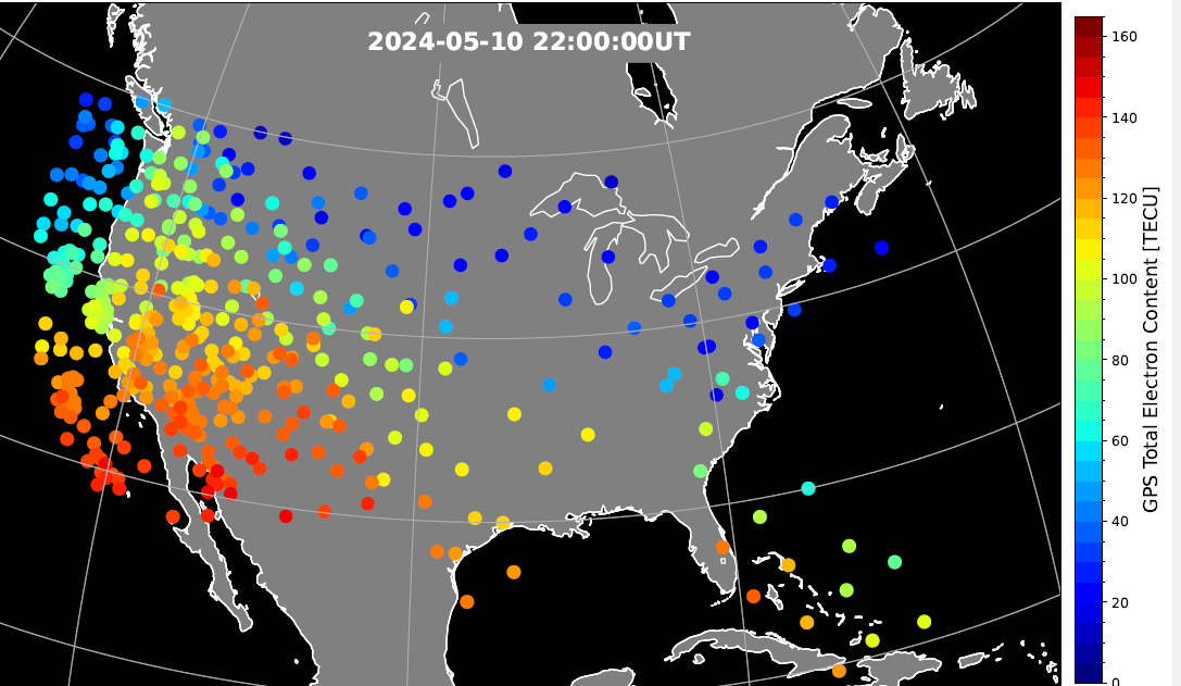
During the geomagnetic storm that took place May 10–11, 2024, GPS users reported significant positioning errors and outages. In particular, farmers in the Central United States reported difficulty in getting a fix with their tractors and other farm equipment.
Also affected, to a lesser extent, was the Southwestern United States.
A new study has identified the cause of the GPS outages by analyzing the data from a 1‐Hz GPS receiver network. Standalone GPS position errors In precise point positioning (PPP) mode in the Central United States reached 70 meters on May 10. The errors were attributed to a steep wall in ionospheric plasma that rapidly moved southward.
In the soutwestern states, the GPS position errors were elevated 10 to 20 meters because of the enhanced plasma density.
Vertical protection level as provided by WAAS.
Then, on May 11, intense auroral activity caused rapid enhancements in the ionospheric plasma, leading to abrupt position errors of 10 meters. Network‐based position systems likely encountered even longer duration of position errors because these ionospheric disturbances are localized.
“These findings highlight the need for more accurate understanding of ionospheric plasma conditions, as well as software and hardware improvements, to reduce disruptions during space weather events,” report the authors of “Spatio‐Temporal Evolution of Mid‐Latitude GPS Scintillation and Position Errors During the May 2024 Solar Storm.” Authors are Waqar Younas, Yukitoshi Nishimura , Weixuan Liao , Josh L. Semeter, Sebastijan Mrak, Jade Morton and Keith M. Groves. The full report will appear in an upcoming issue of the Journal of Geophysical Research: Space Physics and is now available on ResearchGate.
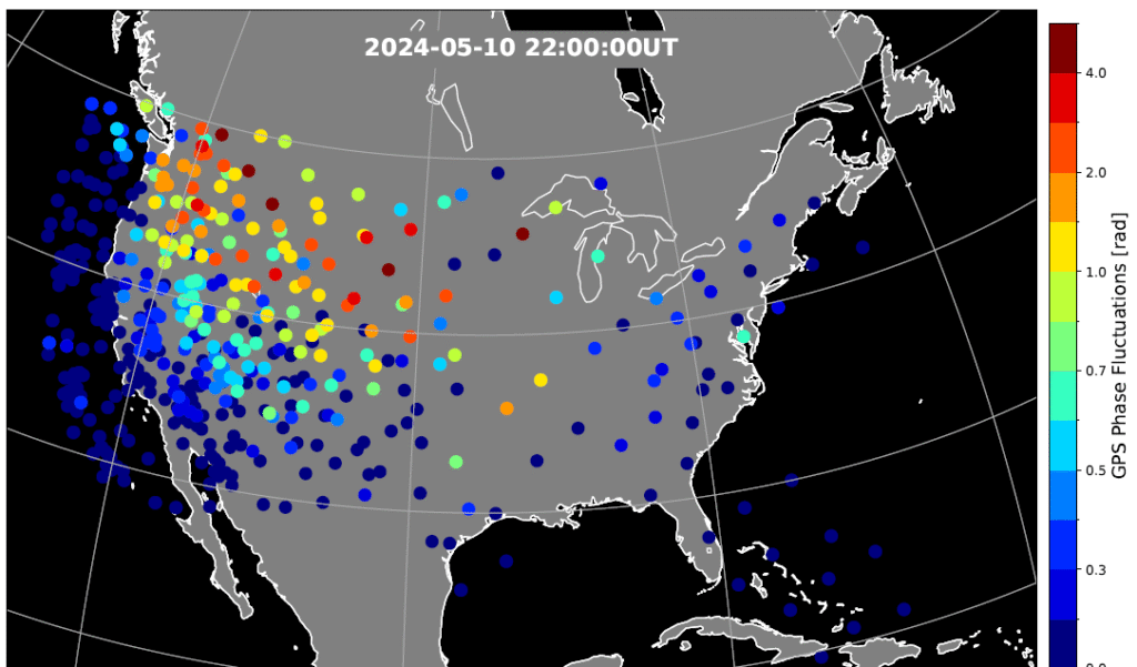
Figure 2. Phase scintillation index over the United States during the geomagnetic storm at 22:00 UT on May 10, 2024. The map is derived from the Global Positioning System (GPS) signals. The map shows enhanced phase fluctuations that impacted GPS position accuracy. Adapted from Figure 4d of the paper. (Credit: Authors)
Key Points
PPP failed to converge in the SED and trough, while PPK became unstable after CME arrival until the recovery phase.
SED, EIA, and trough created position errors on the noon‐evening sector. Substorms caused position errors on the nightside.
Scintillation, cycle slips, satellite geometry and ray bending were identified as contributing factors to the large position errors.
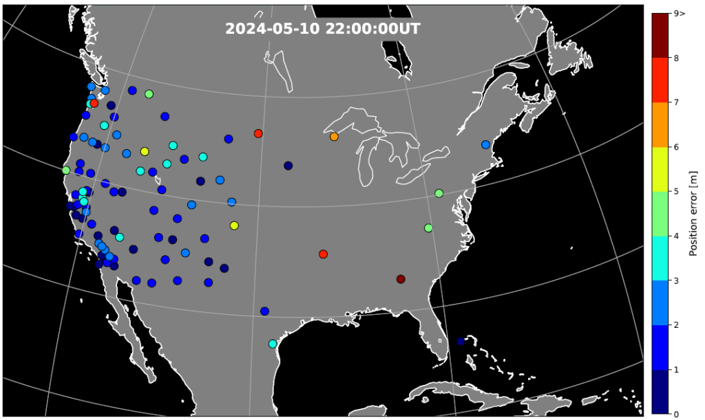
Figure 3. GPS position error over the United States during the geomagnetic storm at 22:00 UT on May 10, 2024. The map is derived from the Global Positioning System (GPS) signals. The map shows large error occurs at trough boundary and enhanced TEC regions. Adapted from Figure 5d of the paper. (Credit: Authors)
The study investigates impacts of the May 2024 superstorm on the mid‐latitude GPS scintillation and position errors. Using 1‐Hz GPS receiver data, the research team identified position errors in PPP mode reaching up to 70 m in the Central United States during the storm main phase on May 10.
The PPK solution becomes unstable following the arrival of storm and lasted till the recovery phase, coinciding with reported GPS outages of farming equipment. The large position errors were attributed to strong scintillation and carrier phase cycle slips around the equator-ward boundary of the ionosphere trough, where large total electron content (TEC) gradients and irregularities were present.
In the Southwestern United States, position errors of 10–20 m were associated with the storm‐enhanced density and equatorial ionization anomaly. Scintillation and cycle slips in this region were minor, and bending of the GPS signal paths (refractive effect) is the probable cause of the position errors. PPP outages were also associated with sudden changes in the geometric distributions of available GPS satellites used in position calculations.
On May 11, energetic particle precipitation during substorms led to abrupt jumps in TEC and scintillation, resulting in rapidly evolving position errors of up to 10 m. These findings highlight the critical role of storm‐time plasma transport, precipitation and irregularity formation in degrading GPS performance.
“The study underscores the need for accurate ionospheric state specification, improved signal processing technique, real‐time ionospheric corrections, and optimized satellite selection algorithms to enhance navigation resilience during severe space weather events,” the authors conclude.
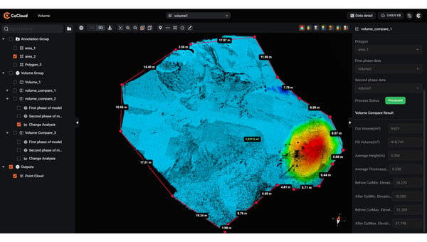
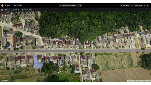
CHC Navigation (CHCNAV) has introduced CoCloud, a cloud-native platform developed for 3D data processing, management and collaborative analysis. The platform is designed to handle multi-source 3D data and supports streamlined workflows from data acquisition to deliverable creation, eliminating the need for local hardware investment.
CoCloud incorporates an advanced photogrammetry engine capable of efficiently processing data from sources such as aerial imagery and lidar scans. The platform produces digital orthophotos, point clouds and OSGB models with a high level of precision suitable for professional applications.
The platform offers tools for online data visualization, sharing and real-time collaboration on tasks such as volume calculations and point cloud editing. Its interface is designed to be intuitive and user-friendly, so users can perform complex 3D data operations without requiring extensive specialized training. CoCloud supports a range of data formats and includes features for dataset and timeline management.
Photo: CHCNAV
The platform offers API access and private deployment options, which allows organizations to integrate the platform into existing systems and customize workflows, from initial data collection through to final application delivery, according to their operational needs.
The platform uses distributed data centers located in Germany and Ireland for localized storage and processing. Both facilities comply with the European Union’s General Data Protection Regulation for reliable data protection throughout collection, transmission and storage.
Radio waves emanating from secretive facilities run by Russia’s military are the culprit behind GNSS jamming in the Baltic Sea, according to Defense News.
The news outlet reports that Polish researchers collected jamming and spoofing information on incidents covering the Gdansk airport, shipping lanes, and the airspaces of Estonia and Finland. The interference has been recorded almost daily since Russia’s full-scale invasion of Ukraine in February 2022, resulting in flight cancellations, airport closures and commercial ships steering off track.
In March, eight European countries, including the Baltic states, Finland, Poland, France, the Netherlands and Ukraine, lodged a complaint with the UN about the practice. Several UN agencies have also taken up the issue, including the International Maritime Organization, the civil aviation authority ICAO and the International Telecommunications Union.
Russia, itself a Baltic Sea country, has not responded to the charges of interference. Likely origin spots include Kaliningrad, which is between Poland and Lithuania, and the St. Petersburg area. Both regions are known to have a heavy Russian military presence, including divisions specialized in electronic warfare.
Precise Point Positioning (PPP) has long held promise as a standalone, high-accuracy positioning technique, but its slow convergence and complexity in ambiguity resolution have limited widespread use. Over the past decade, GNSS modernization (GPS, Galileo and BeiDou) has introduced multi-frequency, high-precision signals, enhancements that expand opportunities for precise positioning.
Yet challenges remain, especially in environments with obstructed views or fast-changing motion. High-fidelity corrections and real-time performance are critical for sectors like smart transportation, robotics and disaster response.
Further in-depth research is needed to refine PPP solutions and meet the demands of real-world, dynamic applications.
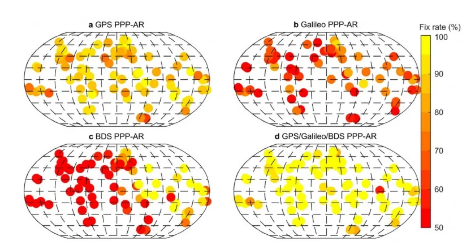
A collaborative research team from Wuhan University and affiliated institutions has published a major study in the July 2025 issue of Satellite Navigation. The team developed and validated an enhanced PPP and PPP-RTK framework using next-generation GNSS signals and satellite augmentation services.
The study evaluated the performance of BDS-3’s PPP-B2b and Galileo’s HAS services across a variety of experimental settings, revealing dramatic improvements in positioning accuracy, convergence time, and reliability.
These breakthroughs offer a practical roadmap for deploying real-time high-precision navigation at global scale.
The researchers constructed an integrated precise point positioning with real-time kinematic (PPP-RTK) system incorporating real-time atmospheric corrections, observable-specific bias (OSB) products, and multi-constellation satellite data. Through extensive global experiments, they demonstrated that a combined GPS/Galileo/BeiDou configuration reduced static convergence time to under 5 minutes while achieving horizontal accuracy below 2 cm. In dynamic tests — including a real-world vehicular trial in Wuhan — PPP-RTK achieved sub-5 cm accuracy with instant or near-instant convergence, even under rapidly changing observation environments.
These systems proved especially effective when paired with atmospheric modeling techniques like Kriging and distance interpolation. With fix rates exceeding 98%, the results underscore PPP-RTK’s readiness for mission-critical applications in rapidly changing environments.
Additionally, the study evaluated augmentation services: the BeiDou PPP-B2b and Galileo High Accuracy Service (HAS). Both were found to significantly accelerate convergence (to under 15 minutes and 100 seconds, respectively) and deliver decimeter-level accuracy in kinematic scenarios.
“This study marks a turning point in the quest for real-time, high-accuracy positioning,” said Xiaodong Ren, lead author and professor at Wuhan University. “By merging advanced GNSS signals, atmospheric corrections, and real-world testing, we’ve demonstrated that PPP-RTK can deliver fast, stable and highly accurate results — even in the most demanding environments. These capabilities are essential for the next generation of autonomous systems, from self-driving cars to drones and beyond.”
The ability to achieve centimeter-level positioning accuracy quickly and without reliance on dense base station networks opens doors for a wide range of smart technologies, Xiaodong said. PPP-RTK has the potential to reshape industries such as precision agriculture, surveying, transportation logistics, and unmanned systems.
This study provides a robust framework and empirical validation for real-world adoption of high-precision GNSS applications, according to the authors. “As satellite constellations and augmentation services continue to evolve, PPP-RTK is poised to become the foundation of global positioning solutions — reliable, scalable, and ready for deployment in tomorrow’s connected world,” Xiaodong said.
A new Esri book, GeoAI: Artificial Intelligence in GIS,provides real-life stories about public- and private-sector organizations as well as NGOs and nonprofits successfully using GeoAI (artificial intelligence) to manage processes, workflows, policies and communication. The book includes a technology showcase that provides ideas, strategies, tools and actions to help jump-start the use of GeoAI.
Organizations around the globe rely on geographic information system (GIS) technology to manage and analyze data through the powerful lens of location to tackle some of the toughest business and societal challenges. The emergence of AI-enhanced GIS has opened new opportunities to automate complex spatial analyses and harness the full power of spatial analysis.
This democratization of GIS can help everyone make better decisions faster, from city planners and policymakers to businesses, research groups, and constituents. In addition, organizations that already use GIS extensively will benefit from the ability to tackle complex problems by combining human GIS expertise with AI capabilities.
GeoAI: Artificial Intelligence in GIS, by Matt Artz, Ismael Chivite and Nicholas Giner, publishes Sept. 2, by Esri Press. While the book officially publishes on Sept. 2, Esri is printing it early so that it will be available at the Esri User Conference in San Diego July 14-18.
GeoAI: Artificial Intelligence in GIS Authors: Matt Artz, Ismael Chivite, and Nicholas Giner Publication Date: September 2, 2025 $39.00, 120 pages 5.5 x 8” Full-color illustrations, maps and photos throughout Print ISBN: 9781589488441 eISBN: 9781589488458
“Seen & Heard” is a monthly feature of GPS World magazine, traveling the world to capture interesting and unusual news stories involving the GNSS/PNT industry.
West Point Cadets Map Electronic Warfare West Point cadets conducted a senior thesis project investigating the use of GNSS technology to map and visualize electronic warfare activities in the South Pacific, specifically focusing on GNSS spoofing. Their research, centered on the Huangpu River and Northeastern Shanghai, aimed to identify patterns of malicious GNSS interference and potential perpetrators, highlighting the strategic and economic motivations behind these actions in the region. By developing data visualizations of spoofing incidents, the cadets created a model that could be scaled up to analyze larger areas.
Credit: Eric S. Bartelt / USMA PAO-VI
South Africa Rising Above Water Researchers from the University of Bonn have found that South Africa’s land is rising by up to 2 mm per year, not because of deep mantle activity, but due to water loss from severe droughts. This uplift was detected using the TrigNet network of GNSS stations, which precisely measures changes in land elevation. As groundwater is depleted, the Earth’s crust rebounds upward — a process GNSS stations can monitor in real time.
Credit: THEGIFT777 / E+ / Getty Images
Türkiye to Launch Homegrown Satellite Navigation and Mapping System Türkiye is developing the Regional Positioning and Timing System (BKZS) to launch its own GPS and mapping application, in an effort to reduce dependence on foreign technology and enhance cybersecurity amid growing industrial automation. The system will provide precise location, navigation and timing data via Turkish satellites as an alternative to global systems including GPS, supporting critical sectors such as military operations, civilian communications, smart transportation, and precision agriculture.
Quantum Navigation System Serves as GPS Backup Q-CTRL, a quantum infrastructure software company based in Sydney, Australia, has demonstrated a new quantum navigation system, Ironstone Opal, as a backup to GPS technology. The Ironstone Opal system uses quantum sensors to detect variations in the Earth’s magnetic field, determining precise geographic coordinates with the help of artificial intelligence-based software. Ironstone Opal is passive and does not emit signals, making it resistant to detection and jamming. Field trials showed the system outperformed a high-end inertial navigation system and served as a reliable GPS backup by up to 50 times in ground vehicles and 11 times in aircraft.
Xona Space Systems’ Pulsar-0 satellite, the company’s first production-class asset for a commercial navigation constellation, is now operational and undergoing in-orbit testing. Launched in March 2024 on SpaceX’s Transporter-10 mission, Pulsar-0 is designed to assess the performance of Xona’s Pulsar architecture, which aims to provide high-accuracy, resilient positioning, navigation and timing (PNT) services from low-Earth orbit (LEO).
According to Xona, Pulsar-0 is transmitting LEO-based PNT signals using a payload built to support signal authentication and increased resilience against interference — capabilities that have become more important as concerns about vulnerabilities in traditional GNSS systems grow. The system’s encrypted and authenticated signals are intended to mitigate risks from jamming and spoofing, and deliver stronger, more reliable service in environments where legacy GPS may be degraded.
Xona’s Pulsar constellation is being developed as a commercial complement to GNSS, offering centimeter-level accuracy and greater resistance to interference through modernized signal design and LEO deployment. The company reports that its initial signal waveforms are already being used by select government and commercial partners for prototyping and validation.
Pulsar-0’s technical objectives include:
High-precision GNSS corrections: Real-time correction data from LEO, targeting position accuracy within 10 cm.
Signal authentication: Cryptographically verifiable signals to reduce the risk of spoofing.
Jamming resistance: A signal strength up to 100 times greater than GPS, enhancing reliability in contested or congested radio frequency environments.
Stronger signals: Stronger signals designed to perform in obstructed locations, such as indoors or in dense urban areas.
The Pulsar-0 mission is primarily focused on validating Xona’s core technology and enabling live sky testing with early partners, paving the way for future launches and eventual commercial operations. The company aims to launch a constellation of hundreds of satellites to provide persistent, redundant PNT coverage for sectors including defense, logistics, mining and autonomous systems.
Further details on Pulsar-0’s performance are expected as data collection and testing continue throughout the year.
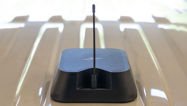
Taoglas has introduced the Patriot series, a compact, multi-function combination roof mount antenna designed for connected vehicle fleets in emergency services, utilities and commercial sectors. The Patriot integrates up to 18 antenna elements within a single low-profile enclosure, aiming to provide robust multi-network connectivity while reducing vehicle roof clutter and simplifying installation processes
The antenna was originally developed for the Ford Interceptor, allowing for a direct replacement of the vehicle’s OEM antenna. This approach maintains the original antenna’s functionality and adds multi-radio connectivity, eliminating the need for additional holes to be drilled in the vehicle roof. The design is intended to streamline and reduce installation time and costs for upfitters, offering public departments potential savings on antenna-related expenses and removing the requirement to fill in roof holes when vehicles are resold.
The Patriot supports 5G and 4G cellular networks across the 600–6000 MHz range, dual-band GNSS (L1 and L1/L5) with a secondary GNSS (L1), Wi-Fi at 2.4 GHz, 5.8 GHz and 7.1 GHz, SDARS at 2.3 GHz, and LMR/TETRA at 380 MHz to 400 MHz and 700 MHz to 900 MHz. This enables the antenna to deliver concurrent broadband, navigation, telemetry and voice services. A dedicated whip element with full P25 VHF/UHF/700-900 MHz support is available in multiple lengths to meet various frequency requirements.
The platform is flexible and scalable, with the patent-pending design allowing for customization to specific application needs. Full 17- and 18-in-1 configurations are currently available, and additional variants with up to 18 integrated elements are planned based on customer requirements. This modular approach enables organizations to match antenna performance and connectivity with operational needs while maintaining a consistent mechanical design.
The Patriot’s housing is rated IK08 and IP69K for impact and water resistance, measuring 205 mm in length by 180 mm in width, with a variable whip height between 60 mm and 164 mm. The enclosure is designed to fit between vehicle roof ribs and uses the existing OEM mounting hole. A custom-engineered foam gasket ensures a secure and interference-free installation on curved vehicle roofs. The aerodynamic design is intended to enhance vehicle aesthetics and reduce wind resistance, and the antenna is available in black, white and other colors to match vehicle exteriors.
Signal performance is engineered for optimal gain, isolation and efficiency across all supported frequency bands. Cable types, lengths and connector options are customizable to suit specific installation requirements.
This newsletter is going to highlight some history of the Coast and Geodetic Survey and provide the latest information on the National Geodetic Survey (NGS) new National Spatial Reference System (NSRS). First, every year my brother and I get together and travel to visit friends and relatives. He lives in Montana, and I live in North Carolina, so our yearly trips are typically 10 to 14 days long. As in all trips, I look for geodetic marks along the way. This year we traveled to coastal Maine to visit lighthouses and of course eat lobster rolls. We visited 12 Lighthouses along the Maine Coast. Lighthouses have both historical and navigational importance. The lighthouses were essential in guiding sailors through rocky shores. Portland Head Light commissioned by George Washington in 1791 is Maine’s oldest lighthouse and still guides vessels into Portland Harbor. We found NOS benchmark 841 8031 B 1979 on the grounds of this lighthouse. Pemaquid Point Lighthouse is managed by the Friends of Pemaquid Point Lighthouse, a chapter of the American Lighthouse Foundation, and remains an active aid to navigation under the ownership of the U.S. Coast Guard. We could climb up the Pemaquid Point Lighthouse, so I took a photo of the view from the top.
One of my brother’s requests was to visit the first place in the continental United States to see the sunrise. However, the location of the first place in the continental United States to witness the sunrise depends on the time of year. As indicated in the box titled “First Places to See the Sunrise in the Continental U.S.” Mars Hill is the first place to witness the sunrise in June.
841 8031 B 1979 — Mark located on grounds of Portland Head Light. (Credit: Dave Zilkoski)Pemaquid Point Lighthouse (Credit: Dave Zilkoski) View from Pemaquid Point Lighthouse (Credit: Dave Zilkoski)
First Places to See the Sunrise in the Continental U.S.
October 7 to March 6: During these months, Cadillac Mountain in Acadia National Park, Maine, holds the distinction of being the first place in the continental U.S. to see the sunrise. Its elevation of 1,530 feet and eastern location make it ideal for early morning views. reddit.com+10nps.gov+10acadiamagic.com+10
March 25 to September 18: In the spring and summer, Mars Hill in Aroostook County, Maine, takes the title. Its northeastern position allows it to catch the first rays of sunlight during this period. newengland.com+2en.wikipedia.org+2aa.usno.navy.mil+2
Around the Equinoxes: Approximately during the weeks surrounding the spring and fall equinoxes, West Quoddy Head in Lubec, Maine—the easternmost point of the contiguous U.S.—experiences the nation’s first sunrise. reddit.com+2en.wikipedia.org+2en.wikipedia.org+2
That said, when we travel together, we always recover geodetic marks, so we chose to visit Cadillac Mountain even though in June the first place is located on Mars Hill in Aroostook County.
As many of you know, I worked for NGS for 35 years so reconning monuments is exciting to me. We found six marks in a radius of about two hundred meters on Cadillac Mountain. We will talk about them in a minute.
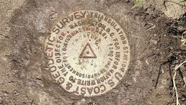
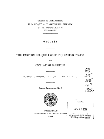
Cadillac Mountain was important to me because from 1833 to 1898, the Coast and Geodetic Survey performed a triangulation project that extended from Calias, Maine, to New Orleans, Louisiana. The project was published as the Eastern Oblique Arc of the United States. The station Mount Desert 1856 that was located on Cadillac Mountain was part of this project. A report published in 1902 describes the Eastern Oblique Arc project and can be downloaded here.
USCGS Special Publication Number 7. (Credit: USGS)
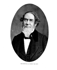
According to the 1902 report, horizontal observations at station Mount Desert 1856 were acquired by Alexander Dallas Bache. That may not mean much to most people, but Mr. Bache was the second superintendent of the Coast Survey and was particularly important to the advancement of geodesy in the United States. As a side note, the Coast Survey was renamed the Coast and Geodetic Survey in 1878. The change reflected the agency’s expanded mission beyond coastal charting to include geodetic surveys of the nation’s interior, prompted by the growing importance of geodesy in its work.
Bache’s leadership of the U.S. Coast Survey
In 1843, Bache was appointed superintendent of the United States Coast Survey, succeeding Ferdinand Rudolph Hassler. Under his leadership, the Coast Survey expanded its missions to include hydrography, geodesy, topography, and the printing arts. He initiated geomagnetic studies, directed tide observers to make meteorological observations, and developed mathematical techniques for tide predictions and adjusting triangulation networks. Bache’s administrative skills transformed the Coast Survey into one of the foremost scientific organizations globally, providing critical data for navigation and commerce.
Alexander Dallas Bache
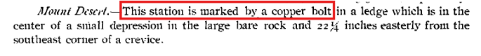
According to the description of Mount Desert in the 1902 USCGS report, the station was marked by a copper bolt in a ledge (see the box titled “1856 Description of Mount Desert”). The 1902 description of the station on the NGS Datasheet stated that it was a hole drilled in a rock (see the box titled “1902 Description of Mount Desert”). I’m not sure why there is a discrepancy between the two descriptions but in 1931 the Maine Geodetic Survey found the drill hole, and based on measured references to other drill holes in the area that were documented in the original description decided that it was the location of the original station (see the box titled “1931 Description of Mount Desert”). At that time, a Coast and Geodetic Survey Disk with Reference Marks were installed by the Maine Geodetic Survey.
A description of Mount Desert from 1856. (Photo: NGS) A description of Mount Desert from 1902.A description of Mount Desert from 1931.A description of Mount Desert from 1931.
As I previously stated, we found six marks in the area. The boxes titled “Photos of Mount Desert 1856 and Reference Marks” and “Photos of Other Marks on Cadillac Mountain” provide photos of the monuments we found on Cadillac Mountain. One may note that the reference mark 2 monument is in worse shape than the reference mark 1 and the Mount Desert monument. The 1944 recovery note stated that reference mark 2 was covered with roadway stone. There was not any stone covering reference mark 2 when I found it. Reference mark 1 is located behind some trees and out of sight of the path.
When I arrived at the site, there were a group of people looking at reference mark 2. I held a little lecture on the importance of geodetic monuments and how this site was first occupied in 1856; and, of course, I highlighted the importance of geodesy.
Photos of Mount Desert 1856 and reference marks. (Credit: Dave Zilkoski)
I was thrilled to stand in the very spot where Alexander Dallas Bache took geodetic measurements in 1856. [I know—people joke that I need to get a life, all because I get so fired up over geodetic monuments.]
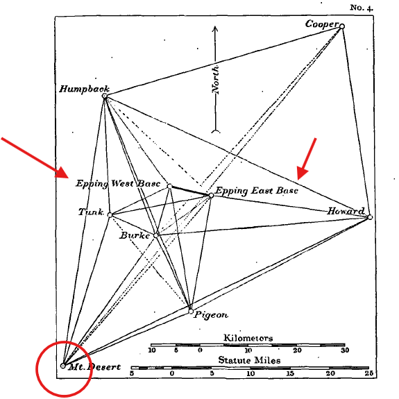
The box titled “Abstract of Observations at Mount Desert” provides a summary of the directions from Mount Desert to the stations involved in this phase of the project. The box also includes a photo of an instrument, a 75 cm theodolite, which was used to perform the observations. The box titled “Diagram of Network Depicting Epping Base Line” provides a diagram that was included in the 1902 USCGS report.
As a side note: during the 1970s as a NGS employee, I personally coded abstracts similar to this one to convert archival data into computer-readable form in support of the North American Datum of 1983 (NAD83) project. Once all data were in computer-readable form, they were reviewed for correctness and combined in an adjustment resulting in what is known as NAD 83 (1986). See the NGS report for some details of the NAD 83 (1986)here.
The other marks we found on Cadillac Mountain included a US Geological Survey Benchmark – K 24 1934, a bent pipe denoted as Cadillac Ground, and a Department of Interior Geological Mark – Cadillac 1975. All these marks are within a 200-meter radius of each other. My understanding is that Cadillac Ground was established because Mount Desert was obstructed by trees. I have provided weblinks for those that would like more information on these marks.
After visiting more lighthouses along the Maine Coast, we traveled back to Boston and visited Waldon Pond and Thoreau’s family home. Why Thoreau you ask? In 2018, the Surveyors Historical Society and NSPS Foundation recognized Thoreau for his work as a surveyor by establishing a commemorative monument at Thoreau’s family farm.
Thoreau described surveying as a “noble employment” that kept him close to nature: “Surveying … brings you within hearing of [the birds]” – https://www.heritagesurveys.com/famous-surveyors. Surveying and geodesy are indeed noble professions; they provide the foundation for all geospatial products and services.
Photo of Commemorative Mark at Thoreau’s House. From left to right, Thoreau – A Surveyor, Thoreau Monument and drawing lines. (Credit: Dave Zilkoski)
Finally, we left Boston for Syracuse to visit my younger brother and sister. I attended the SUNY College of Environmental Science and Forestry (SUNY ESF) which is immediately adjacent to Syracuse University campus. Both of my brothers attended Syracuse University, so we like to walk around campus whenever we visit Syracuse. During our trip to the University, we recovered the monument Thornden 1934. Thornden 1934 was significant to me because I recovered this monument over 50 years ago, as part of a special project that I performed for my geodesy class.
Thornden 1934 (Credit: Dave Zilkoski)
I hope this was not too boring for you, but I real enjoy history and especially the history of the geodetic network of the United States. Today, you can use modern surveying technology to obtain a more accurate coordinate in seconds where it took days to months in the past. That is amazing!
Now, what is the latest with the modernization of the National Spatial Reference System? On June 17, NGS announced that they incorporated four groups of NSRS modernization products to the NGS beta website.
Multiple NSRS Modernization Products Published to Beta
NGS has released the following four groups of products to the NGS beta website to solicit review and feedback from stakeholders as part of the modernization of the National Spatial Reference System (NSRS): (Note: These products are not final and should not be used for anything other than review and testing.)
North American-Pacific Geopotential Datum of 2022 (NAPGD2022). This datum will replace the North American Vertical Datum of 1988 (NAVD 88) and all other vertical datums for islands in the United States. It will serve as a foundational component of the modernized National Spatial Reference System (NSRS), providing precise definitions for orthometric height (elevation). The release includes the defining grids that collectively make up the datum along with a number of supporting products to visualize the datum.
Products. All NAPGD2022 products are provided as grids for the following: GEOID2022, DEFLEC2022, GRAV2022.
Example coordinates. Coordinates and product values are computed for numerous example points throughout NAPGD2022 and provided in a table. NAPGD2022 Experience. Interactive online maps showing NAPGD2022 products for all regions that can be used on a computer or mobile device to query any location.
Maps of NAPGD2022 products. Static map images of NAPGD2022 products for all regions.New Terrestrial Reference Frames of 2022 for North America (NATRF2022), Pacific (PATRF2022), Caribbean (CATRF2022), and Mariana (MATRF2022) plates. These four geodetic reference frames will replace the North American Datum of 1983 (NAD 83). They will serve as a foundational component of the modernized NSRS, providing precise definitions for geodetic latitude, longitude, and ellipsoidal height.
Euler Pole Parameters of 2022. All of the new terrestrial reference frames are defined by transformation from the International Terrestrial Reference Frame of 2020 (ITRF2020) using Euler Pole Parameters (EPPs) that model tectonic plate rotation.
State Plane Coordinate System of 2022 (SPCS2022). A system of map projections for accessing the modernized NSRS. Zone designs have been incorporated into the following beta products and services:
Zone information tables. SPCS2022 zone definitions, example coordinate computation results, minimum and maximum coordinate values, and minimum coordinate differences with overlapping SPCS2022 zones and with other coordinate systems, provided as interactive tables that can be sorted and filtered.
SPCS2022 Experience. Interactive online maps showing distortion for all SPCS2022 zones that can be used on a computer or mobile device to get distortion at any location or to view zone definitions.
Maps of SPCS2022 zones and distortion. Static map images of SPCS2022 zone layers, number of zones, and distortion with performance statistics.
NGS Coordinate Conversion and Transformation Tool (NCAT). This version can be used to perform SPCS2022 coordinate conversions at any location for all SPCS2022 zones. Later beta versions will include the ability to transform between reference frames and vertical datums.
Products found on the NGS beta website are preliminary releases that are for testing and evaluation only; they are not final products nor do they contain any authoritative NGS data or tools. To provide feedback on any of the content on this site, please email [email protected].
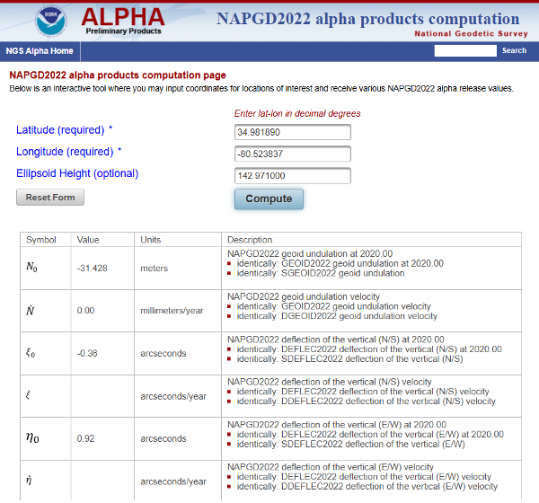
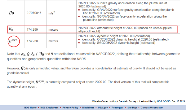
Everyone should review these products and provide their feedback to NGS. That said, my April 2025 newsletter highlighted the NAPGD2022 Alpha product that was moved to the Beta site. The Beta product is like the Alpha product, but it does not have an option for an interactive computation. The Interactive Computation Option provided essential information about NAPGD2022 and would be helpful to geospatial users for obtaining a better understanding of the differences between NADGP2022 orthometric heights and NAVD 88, and GEOID2022 geoid heights and hybrid GEOID18 geoid heights. My April 2025 newsletter highlighted the interactive computation option.
Alpha interactive computation page (Credit: NGS)
As noted in my April 2025 newsletter, I downloaded the data and created my own maps to better highlight local variations. Although users can still view the original via the interactive online map, this personalized version offers clearer insights.
Here are several of my comments on the Beta products based on my preliminary review:
The NAPGD2022 difference map (NAPGD2022 minus Historical in meters) uses 25 cm intervals, which are too coarse to reveal the finer local variations between published benchmarks accurately.
The NAPGD2022 Difference map should have an overlay of the marks used in the creation of the difference map. This would allow users to identify marks in their region of interest. Clicking on a mark should link to the NGS datasheet and Passive Mark Page.
The beta page for NATRF2022, PATRF2022, CATRF2022, and MATRF2022 is not particularly helpful for everyday geospatial users. There should be an Interactive Computation Option to enter NAD83 (2011), epoch 2010 coordinates where the routine transforms the coordinates into ITRF 2020, epoch 2020, as well as estimates in the new terrestrial reference frames – NATRF2022, CATRF2022, PATRF2022, and MATR2022.
Both the State Plane Coordinate System of 2022 (SPCS2022) and The NGS Coordinate Conversion and Transformation Tool (NCAT) are good tools for users to obtain an understanding of the differences and changes in the SPCS especially for their State. That said, like above, there should be an option to enter NAD83 (2011), epoch 2010 coordinates where the routine will transform the coordinates into ITRF 2020, epoch 2020, as well as estimates in the new terrestrial reference frames – NATRF2022, CATRF2022, PATRF2022, and MATR2022. The routine does have a note that states users can transform their coordinates using HTDP, but NGS should incorporate this process in the NCAT beta product.
Note from Beta NCAT product: This beta version of NCAT supports beta State Plane Coordinate System of 2022 (SPCS2022) but not transformations between reference frames or geopotential datums. NAD 83 latitude and longitude can be used as input, but the output coordinates will differ horizontally from actual SPCS2022 by up to a few meters, depending on location (likewise for UTM and USNG). If NAD 83 ellipsoid heights are used, the linear distortion and combined factor will differ from SPCS2022 values by a small amount, within ±0.3 parts per million (ppm). To reduce these differences, NAD83 epoch 2010.0 coordinates can first be transformed to ITRF2020 epoch 2020.0 using the Horizontal Time-Dependent Positioning (HTDP) tool.
I plan to provide these comments to NGS through their feedback email process. Everyone should take time to review these products and provide your feedback to NGS. Remember, NGS placed these four groups of products on the NGS beta website to solicit review and feedback from stakeholders as part of the modernization of the National Spatial Reference System (NSRS) process. Users should review these Beta products and consider two questions:
1. Do these products provide sufficient information and detail for documenting how I will deliver my products and services under the new NSRS?
2. Do I need additional information or tools from the NGS to better understand the changes and impacts of the new NSRS?
Your feedback will help NGS improve the Beta products.
News outlet MSN has published a slideshow detailing seven take-aways from recent GNSS spoofing defense moves against Iranian missiles headed toward Israel. The missiles instead ended up in the Mediterranean Sea, apparently because of successful electronic hacking.
“The incident has caused tremors within the defense and cyber-defense communities, pointing to the mounting sophistication of electronic warfare and the weakness inherent in contemporary navigation systems,” the report states.
The event is being studied as a sophisticated method that “deceived” the missile’s guidance, making it continue on a reasonable course while deviating it from its targeted direction, an advance in electronic warfare that requires knowledge of the missile’s flight algorithms.
“Spoofing detection is much more difficult than jamming, since spoofed signals are made to mimic legitimate signals. Sophisticated detection techniques, like those employing pseudorange difference and sum sequence linearity, are being researched to separate genuine from spoofed GNSS signals. These detection techniques examine the consistency and conduct of signal measures, searching for minute discrepancies that indicate spoofing efforts.”
Spoofing is also affecting civilian sectors, such as when cargo ships collided in the Strait of Hormuz. The International Air Transport Association and the European Union Aviation Safety Agency have published a comprehensive plan to mitigate risks stemming from GNSS interference. The plan was part of the conclusions from a jointly hosted workshop on the topic of GNSS interference.
Agencies also are seeking reliable countermeasures as well as complementary PNT such as magnetic navigation.