Trimble has introduced the latest version of its smart water infrastructure mapping and work management cloud software — Trimble Connect for Water version 1.9.
The latest release of the geographic information system (GIS) centric software-as-a-service (SaaS) adds real-time, high-accuracy centimeter-level horizontal and vertical GNSS accuracy for capturing 3D asset positions. The new release includes a suite of applications that allow water, wastewater and stormwater utilities to accurately locate, inventory and visualize their infrastructure assets and increase operations and maintenance efficiency.
Trimble Connect for Water cloud software leverages Trimble’s GNSS rugged mobile devices and Esri’s GIS technologies to accurately map, locate and assess the condition of critical infrastructure assets, allowing utilities to keep their field infrastructure data up-to-date and accurate.
The new release now supports Trimble’s Geo 7 Centimeter Edition rugged handheld, integrating 3D mapping into utility field workflows and enabling mobile workers to precisely locate and map the horizontal position and elevation of buried infrastructure.
Trimble Connect for Water version 1.9 can be configured and deployed quickly on a variety of Trimble and non-Trimble mobile devices, laptops, tablets and smartphones, including Apple iPads, iPhones, Android, Windows and Windows Mobile devices to automate fieldwork and eliminate paper-based maps.
Trimble Connect uses the latest Esri ArcGIS for Server, Mobile and ArcGIS Online basemap services. The software is designed to automate a variety of specific water, wastewater and stormwater industry workflows through individual pre-configured “apps” offered within the product and as part of a subscription.
The new version provides standard core apps including Map Book, Manhole Inspector, Leak Repair, Hydrant Inspector, Valve Inspector, Meter Changeout, Incident Repair, Water Mapper, Wastewater Mapper and Stormwater Mapper. In addition, an optional partner app developed for American Flow Control (AFC) hydrant and valve data collection, “AFC Mapper,” can be purchased from AFC and their distributors for use with Trimble rugged handhelds.
Trimble Connect for Water version 1.9:
Offers centimeter-level real-time GNSS accuracy to improve the quality and accuracy of the utility’s GIS data to precisely locate hard to find assets.
Allows capturing accurate vertical elevations in real-time. Combined with horizontal precision, the solution provides high-accuracy GIS data that can be used to measure pipeline slopes, perform flow analysis and generate 3D and hydraulic models.
Supports the Trimble Geo 7 Centimeter edition with an integrated laser rangefinder.
Offers pre-configured Water, Wastewater and Stormwater mapping apps, allowing utilities to quickly start mapping network infrastructure and updating their asset data.
Provides the capability to export data in a variety of formats including Esri File Geodatabase, Shapefiles and MS Excel, which allows users to update the utility’s enterprise GIS or visualize and analyze the collected data using third-party systems.
Trimble Connect for Water version 1.9 is expected to be available in December 2014 from Trimble’s Water Division and its authorized distribution partners.
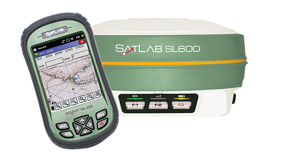
SatLab announced the unit earlier this year as the replacement of its SL500 on-the-pole surveying receiver. After a summer of testing and a premiere showing at InterGeo 2014, held in Berlin in October, SatLab is ready to ship the SL600 to its dealer network and customers.
The new receiver is designed to meet the evolving needs of the surveying market, and is designed for general land, marine and construction applications. At the heart of the rugged unit is a 6G GNSS receiver capable of using all six GNSS satellite networks (GPS, GLONASS, BeiDou, Galileo, QZSS and SBAS), providing reliable operation in demanding conditions, SatLab said.
The SL600 is lightweight at 1.2 kg. Its Xenoy housing holds up well to real-world use, according to test results by SatLab, resistant to 3-meter drops and 2 meters of water submersion. The dual hot swappable batteries provide 18-24 hours of continuous field use, depending on the mode of operation.
The SL600 receiver has a new onboard computer running the LINUX operating system, which ensures easy implementation of new functionalities, often a result of customer-specific requirements. Over time, over-the-air firmware updates will be automatically available, adding new features at no additional charge. Users will be notified by the unit to accept the new firmware updates, or refuse them if they wish to keep their units as is.
The SL600 system is available with various communication capabilities. Cellular 3G and Bluetooth as well USB and RS232 connectivity are standard, and an optional internal 2W Pacific Crest XDL radio is also available. Voice notifications notify the user of issues without the need to watch the status LEDs.
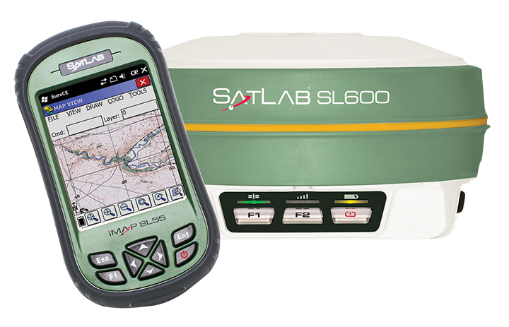
The SL600 system kit includes a compact hard carrying case with the SL55 field controller, which can handle large data files with its high-speed processor and expandable memory. Furthermore, the SL55 has an onboard GPS/GLONASS L1 receiver as well as a GSM modem, which makes the unit a good and rugged companion to use in GIS data collection applications.
As part of the close cooperation between Carlson Software and SatLab Geosolutions AB, the SL600 comes with Carlson SurvCE pre-installed and activated. This ensures an “out of the box” experience for the end customer, SatLab said.
Thorsten Rudolph, Application Center GmbH Oberpfaffenhofen (left), and Rolf Densing, DLR (right), award the Airbus team of Jan Wendel and Wolfgang Kogler the EUR 20,000 grand prize. Photo: ESNC
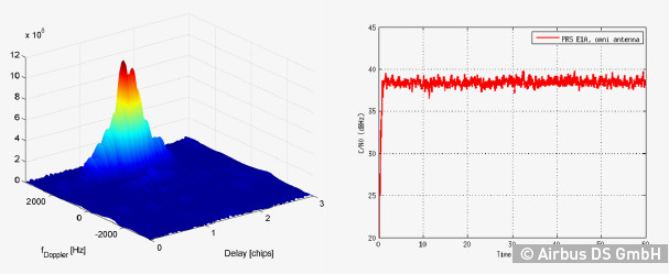
The winner of the European Satellite Navigation Competition (ESNC) 2014 is Airbus Defence & Space, which won over the jury of experts from around the world with its ground-breaking and cost-effective receiver for the Galileo Public Regulated Service (PRS).
The award winners were announced October 23 at an awards ceremony held at the Berlin headquarters of Deutsche Telekom. The awards recognize innovations in the commercial use of satellite navigation technology.
“Award winners Wolfgang Kogler and Jan Wendel from Airbus Defence & Space have taken a cutting-edge approach to designing a low-cost receiver that enables police departments, fire brigades, emergency medical services, and other public entities to make use of the Galileo PRS system,” The ESNC said. “Its core innovation involves the development of a special network architecture that combines the receiver with an assistance server. The concept accounts for all the required security aspects and significantly reduces costs and the complexity of user receivers, thus facilitating broader use of PRS in the realm of public security.”
In addition to the EUR 20,000 grand prize, the design took home Bavaria’s regional prize and the ESNC’s special PRS prize, which was awarded by Germany’s Federal Ministry of Transport and Digital Infrastructure (BMVI) and Federal Ministry for Economic Affairs and Energy (BMWi).
“This special prize reflects our effort to further examine possibilities for the use of PRS applications,” said Tobias Miethaner, Head of the BMVI’s Digital Society, in his opening address at the awards ceremony. “I am delighted to see that the ESNC is already providing an important impetus to the promotion and development of innovative applications of the future Galileo PRS in its first year.”
Over the past decade, the ESNC has brought forth numerous new applications in the field of satellite navigation. The 2014 edition was shaped in particular by the imminent launch of the first Galileo services, with more than 40% of the 434 submissions received from more than 40 countries seeking to employ Galileo/EGNOS in their own products and services.
“Thanks to our international network, we’re in an excellent position to take advantage of Galileo’s operational launch,” said Thorsten Rudolph, managing director of Anwendungszentrum GmbH Oberpfaffenhofen, which initiated and continues to organize the ESNC. “We believe that the ESNC’s function as a leading innovation framework in its field will grant it an equally important role in Europe’s new satellite navigation system.”
Along with the overall winner, 240 experts in the ESNC’s renowned network selected more than 30 other winners in the competition’s regional and special-prize challenges. Under the patronage of Germany’s Federal Minister of Transport, prizes worth a total of EUR 1 million were presented at the awards ceremony. The winners illustrated the fundamental importance of robust, reliable, and secure time and positioning signals for Europe’s digital society through innovations in areas such as transport, health, and the environment.
2014 Special Prize Winners
In addition to selecting its overall winner, the 11th European Satellite Navigation Competition (ESNC) has awarded prizes in six different special categories and to 25 regional winners.
GSA: The most promising application idea for European GNSS
The Galileo for ARA module will use a key feature of Galileo – its E5 broadband signal – to create new possibilities in the development of smartphone applications that require high accuracy. The team thus plans to integrate E5 Galileo receiver modules for enhanced accuracy and develop an antenna interface module to provide better performance. This will offer improved positioning precision with centimetre-level accuracy and a multipath-resistant solution designed for pedestrians and urban environments.
ESA Innovation Prize & Flanders/Belgium — Overall Ranking: 3rd Place
stickNtrack is a disruptive innovation that opens up an abundance of new business opportunities in tracking trailers, containers, machinery, tools, bikes, and more. It functions for up to 10 years without the hassle of charging batteries, managing SIM cards, or any intrusive installations while consuming up to 40 times less power. StickNtrack also lowers life-cycle costs by 50% compared to current compact GPRS/GPS products.
This artificial ground-based solution will significantly boost the coverage of satellite-based augmentation systems (SBAS, such as EGNOS) to ensure safe landings on all airport runways. SBAS assistance can be limited due to a lack of signal coverage in the far north, in the mountains, or in highly urbanised areas. By receiving and retransmitting GPS corrections, the proposed system will enable the use of systems like EGNOS in such difficult environments. Thanks to its competitive cost and reliability, this system will be a strong alternative to conventional instrument landing systems (ILS).
Hail Navigator is a novel system designed to reduce damage caused by hail. The formation of hail can be suppressed by injecting silver iodide into clouds. Hail Navigator combines navigation with a precipitation reporting system that can guide pilots to the optimal locations for their hail suppression missions. The system is complemented by weather observations (including precise times and locations) reported by the local population via a smartphone app as a means of validating weather prediction models. These models constitute an important factor in deciding whether a hail suppression flight is necessary.
trakkies has built the world’s first REAL platform for the Internet of Things (IOT). It enables users to keep better track of belongings, events, tasks, appointments, and more. The start-up has developed IOT nodes with ambient intelligence, a smartphone app, and a back-end cloud system for providing helpful, intuitive services and interacting with people, places, and things. Furthermore, trakkies has designed a novel small-data mechanism that identifies individual people, places, and objects and uses EGNOS signals to create smart location references.
Users now have full access to Fleet Director’s management features via mobile device, in addition to desktop functionality. Also, the latest update offers robust fleet management tools, such as the ability to monitor fuel consumption, increase driver safety, and meet compliance mandates.
“In the current climate, businesses have the ability to achieve high levels of profitability and growth with the help of an advanced fleet management platform,” said Tony Eales, president, Teletrac. “The latest version of Fleet Director churns millions of data transactions daily, providing vital information to help meet company goals across multiple industries and workforce sizes. Businesses are equipped with the actionable data necessary to cultivate and develop their company on multiple levels and gain a competitive advantage in their market.”
Teletrac has modernized Fleet Director in four key fleet management areas: anywhere, anytime mobile access; deeper driver and vehicle behavioral data; enhanced mapping functionality; and advanced safety analytics.
“Fleet management has historically been an at-a-desk job, limiting companies in their productivity and communication. The added flexibility of using modern devices — such as smartphones, laptops and tablets — to do business has increased productivity while also adding expectations from customers,” said Sid Nair, director of Product Management, Teletrac. “As the industry has evolved, so have we.”
Enhancements include:
Mobility: Fleet Director allows users to manage their vehicles from any mobile device or browser through new HTML 5 functionality. The software’s clear and user-friendly interface lets users navigate easily to a targeted location regardless of whether the manager is in the office or on a mobile phone in the field.
Actionable Data: The updated software allows managers to move beyond basic track-and-trace functionality, offering an in-depth look at the overall health of a business. The new Fleet Director is built with more robust driver and vehicle behavioral data, providing businesses with insight into performance areas such as fuel management, power take-off time, engine performance and job-site delivery tracking.
Cutting-Edge Mapping Technology: Mapping has moved beyond location tracking with Fleet Director’s enhanced interactive features. Vehicle and asset mapping is now accessible on easy-to-use Google Maps that toggle between single and multiple views. Managers can consult Fleet Director to pinpoint the exact road their drivers are on while using Google Street View to zoom into the terrain and makeup of the road. These added map enhancements provide fleet managers with tools to have better control of their business.
Advanced Safety Behavior Data: Fleet Director Safety Analytics helps managers get closer to their fleet through insight into key driver safety events, such as speeding, harsh braking, accelerating, stop sign violations and fast cornering. New data-rich dashboards display relevant information that shows the time and date of each event and the number of infractions per vehicle and driver, including the best and worst performance rankings. Safety infractions can be replayed on the map interface to show how an unsafe driving incident occurred in real-time, providing useful data that can prevent the risk of a crash.
The Trimble Geo 7 series of rugged, high-accuracy GNSS handhelds will have RTX correction. Photo: Trimble
Trimble’s RTX technology-based correction services — Trimble CenterPoint RTX, Trimble RangePoint RTX, and the new Trimble ViewPoint RTX — will be available for Trimble Geo 7X handhelds. Trimble made the announcement at Trimble Dimensions.
Trimble RTX technology provides compatible GNSS receivers with correction services that significantly improve accuracy and reliability in obtaining positions worldwide. Geospatial professionals now have more flexibility to achieve the accuracy required by their highly mobile workflows in real-time, without being tied to a base station or local VRS network, Trimble said.
Available worldwide through an IP connection where cellular communication is available, Trimble RTX offers geospatial professionals flexibility in where and when they are able to work. Operational efficiency and productivity in the field is improved by delivering real-time DGNSS corrections directly to the Trimble Geo 7X handheld. Field challenges, such as obstructed satellites and inaccessible locations, are also minimized with Trimble Floodlight and Trimble Flightwave technology options for the Trimble Geo 7X.
The handheld solution is designed for a variety of industries — such as utility companies, municipalities, and environmental management agencies — in which workers are highly mobile and require a reliable, flexible data-collection and asset management solution.
“We have eliminated the complexities of managing multiple correction sources across a large geographically dispersed project or organization,” said Alain Samaha, business area director of GIS and Software for Trimble’s Geospatial Division. “By offering RTX-based correction services, we simplify their work and deliver the accuracy that our customers require.”
A choice of RTX correction services ranging from 4 centimeters to submeter-level horizontal accuracies is available. Customers can choose the appropriate Geo 7X handheld configuration with the RTX-based correction service that meets the accuracy level and capability required for their job.
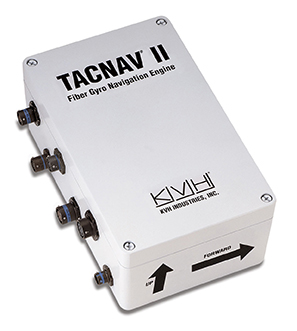
KVH Industries, Inc., has received a $4.3 million order for its TACNAV tactical navigation systems from a new customer who is a major defense contractor providing armored vehicles for an international military client. With a short delivery requirement, shipments for this order are expected to be substantially completed in the fourth quarter of 2014.
“KVH is extremely pleased to be selected by another major defense contractor to provide the tactical navigation solution for their new armored vehicles. Providing precise navigation as well as coordination of vehicles in critical situations is an important tool that helps keep soldiers oriented wherever they operate,” said Dan Conway, executive vice president of KVH’s Guidance and Stabilization group.
KVH’s TACNAV military vehicle navigation systems provide unjammable precision navigation, heading, and pointing data for vehicle drivers, crews, and commanders. TACNAV can also serve as a heading and position source for situational awareness.
In October, KVH received a $19 million contract for the delivery of a new fiber optic gyro-based tactical navigation system for use by an international military customer in an armored vehicle application.
TACNAV systems are in use by the U.S. Army and Marine Corps, as well as many allied customers including Canada, Sweden, Great Britain, France, Germany, Spain, Egypt, Botswana, Australia, New Zealand, Saudi Arabia, Taiwan, Romania, Poland, Turkey, Malaysia, Switzerland, South Korea, Singapore, Brazil, and Italy.
Omnitracs LLC, a provider of fleet management solutions to transportation and logistics companies, has completed the acquisition of XRS Corporation for $178 million. XRS is a provider of mobile-based solutions that enable trucking companies to manage fleets, comply with regulations, and reduce operating costs.
Omnitracs acquired XRS to strengthen its core technology portfolio, adding complementary solutions designed to help fleets solve critical business problems, Omnitracs said. The combined company will continue to deliver transportation management products and services that empower fleets to control virtually every aspect of their business, from improving safety to complying with industry regulations to enhancing productivity and profitability, the company said.
“This acquisition exemplifies Omnitracs’ commitment to delivering solutions that translate into real value and a true competitive advantage for customers,” said John Graham, CEO of Omnitracs. “By integrating XRS into the Omnitracs portfolio of businesses, we can now offer fleets an extended array of industry-leading solutions, helping fleets make intelligent decisions that positively impact all aspects of their operations.”
Together, Omnitracs and XRS will provide end-to-end fleet management solutions to more than 30,000 customers with nearly 1,000,000 mobile assets in 63 countries.
Omnitracs Outlook 2015. In related news, registration is now open for Omnitracs’ first joint user conference — Omnitracs Outlook 2015 — which takes place February 8-11, 2015, in Dallas, Texas.
Omnitracs Outlook 2015 will unite fleet customers of Omnitracs and its business units Roadnet, Sylectus, and Omnitracs Analytics (formerly FleetRisk Advisors). The conference will bring together fleet executives, managers, power users, product experts, specialized technology providers and industry opinion leaders for educational, networking and peer-to-peer sessions designed to help fleets improve operational efficiency, safety and regulatory compliance.
“With just a few months until this ‘don’t miss’ event, we look forward to bringing together our customers from across all Omnitracs business units for an opportunity to learn about the company’s strategic vision, product roadmap and more,” said John Graham, CEO of Omnitracs. “We’re thrilled to have this opportunity to host everyone in our new hometown, Dallas, and look forward to the unparalleled networking and education sessions at Outlook 2015.”
Thesessions at Omnitracs Outlook 2015 will include product-specific breakouts targeted to users of Omnitracs, Roadnet, Sylectus and Omnitracs Analytics; cover the latest transportation and logistics technology trends; and highlight user case studies. Peer-to-peer networking opportunities and the technology expo, featuring integration partners and hands-on solution demonstrations, will deliver additional value to conference participants.
Interested sponsors and exhibitors should contact [email protected].
NovAtel, Inc.’s Calgary facility has been awarded the prestigious 2014 Manufacturing Excellence Award from the Association for Manufacturing Excellence (AME). The award acknowledges North American facilities that have demonstrated excellence in manufacturing and business, and recognizes NovAtel’s dedication to continuous improvement, best practices, creativity and innovation.
A representative of the AME presented the award to NovAtel at the company’s Calgary headquarters on October 23. NovAtel will also be recognized at the 2014 AME International Excellence Inside Conference, November 10-14 in Jacksonville, Florida.
NovAtel Inc. designs and manufactures high-precision, OEM, global positioning products and employs more than 400 people.
During their evaluation, the AME assessment team highlighted NovAtel’s work culture, observing that improvement systems were evident throughout the organization. They also praised the company’s commitment to creating a continuous improvement culture and systems. The assessment team remarked, “NovAtel leadership and plant employees can be proud of the site’s manufacturing excellence achievements to date.”
“We are very proud to receive an award which recognizes NovAtel as a leader in Enterprise Excellence in North America,” said Michael Ritter, president and CEO of NovAtel. “Fostering a culture of innovation, excellence and continuous improvement, in all aspects of our business, is something we strive for every day.”
Ritter added, “Our lean manufacturing initiatives are just one of the many ways we strive to add value for our customers. Making data-driven decisions in combination with fostering employee teamwork, mutual respect and accountability, throughout all levels of our organization, is essential to our long-term success in a global marketplace.”
“This award confirms that we are indeed on the right path 11 years into our ‘Lean’ journey,” said Mike McAloney, VP Operations for NovAtel. “We view ‘Lean and Continuous Improvement’ initiatives as the foundations of the operational excellence that lets us achieve our corporate mission: to generate customer success by providing precise positioning and augmentation technologies that are easy to integrate and provide exceptional return on investment.”
KCS BV has launched a new tiny tracker, the TM-202LAR. It’s the newest addition to the KCS family of TraceME products. The KCS GPRS/GPS range of modules enable users to remotely track and trace people, animals and a variety of objects, such as vehicles, containers, motorcycles, lawn mowers, or other valuable assets.
KCS TraceME TM-202LAR is targeted for personal use, or any other application that needs a small size with long battery life while still featuring the options and server connection that full-size units have.
The TraceME TM-202LAR is KCS’s smallest full featured GPS tracker at 46 x 21 x 6.5 mm, weighing 7 grams. Other features and options include:
GPS, RF and GSM antennas
advanced power saving, down to 2.5µA
10 years of operation from one Lithium C-Cell
RF connectivity, up to 2 km
location-based positioning (LBS/Wi-fi/GPS)
onboard sensors for compass, temperature, acceleration
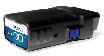
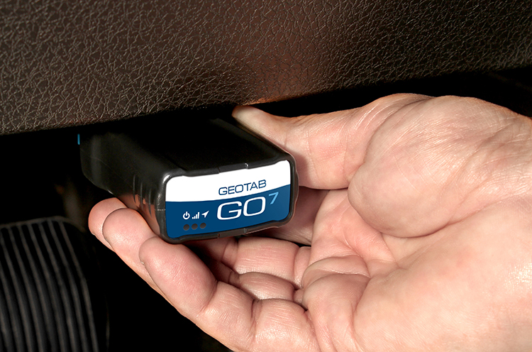
Geotab, a telematics engineering company, has launched its new GO7 telematics device. The GO7 allows fleet management applications to receive vehicle data communications from the engine, drive train, instrument cluster and other subsystems.
The Geotab GO7 is the newest device in Geotab’s line of telematics solutions and has added a number of new features such as programmable CANBUS, OBD, J1708 connection pins, enhanced auto-protocol detection and higher sensitivity accelerometer — making the solution future-proof and cost effective for any fleet to install and maintain, the company said.
The GO7 is an plug-and-play device with internal antennas that eliminates installation and out-of service vehicle time, which significantly lowers installation costs and improves fleet productivity, according to Geotab. The latest edition of Geotab’s GO devices caters to more than one vehicle protocol at a time, allowing the device to collect data simultaneously for all possible datasets, such as RPM, VIN, fuel level, seat-belt detection and odometer. The secondary protocol support provides detailed engine data for a variety of vehicles, including Ford, GM, Chrysler, Volvo and Mazda. The technology is scalable, from light duty, medium duty, to heavy commercial trucks in addition to supporting all major vehicle manufacturers globally, Geotab said.
Photo: Geotab
“Our goal is to provide the most advanced and efficient telematics solution in the industry,” said Neil Cawse, CEO, Geotab. “Together with our MyGeotab software, the all-new GO7 device allows us to provide our customers with the most sophisticated end-to-end fleet management solution on an industry leading platform — providing great productivity enhancements, safety features and cost-savings to our fleet customers.”
Top features of the GO7 include:
Easy plug-and-play installation
External device expandability via IOX Technology
Intelligent in-vehicle driver coaching
Small form factor device
Breakthrough accident detection and notification
Accurate engine diagnostics, DTC, and proprietary engine data
Real-time vehicle data
Fast GPS acquisition time using Almanac OTA support
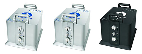
iXBlue unveiled its Marins M series inertial navigation system (INS) at EURONAVAL 2014, held October 27-31 in Paris, France. The series includes the Marins M3, M5 and M7 systems and is designed to address the needs of the world’s most advanced navies for surface-vessel and submarine operations close to shore and in open-sea environments.
Accurate and reliable navigation, including missile alignment, is critical to the success of submarine and surface-vessel missions. The Marins M series raises the bar in performance and scalability by addressing the needs of surface ship navigation under a GPS-denied environment. For submarines, Marins M7 enables three times longer autonomous stealth navigation compared with any available system by offering drifts of less than 1 Nm/72 h.
The Marins M series represents the state of the art in strap-down, fiber-optic gyroscope (FOG) technology, and is combat-ready against GNSS denial, iXBlue said. The military-specification units output position, heading, roll, pitch, depth and velocities, and are perfectly silent. The systems are compatible with a wide range of aiding sensors and can be up and running within minutes.
The extended iXBlue product range, including Quadrans, Octans, Phins and Marins M series systems, now represents even higher scalability of solutions, from attack craft to aircraft carriers and submarines.
More than 30 navies worldwide have selected the iXBlue product range, including previous generations of Marins systems. For example, the UK Royal Navy has adopted advanced iXBlue solutions for its Astute Class submarines.
Under Foundation GEOINT Content Management (FGCM) contracts, Harris will create high-quality data and products of the Pacific, North America, South America, and Africa regions of the world for use by the U.S. intelligence community and military. FGCM will contribute to and maintain a comprehensive, geospatially accurate map of the world that can be accessed quickly as intelligence, operational, and crisis needs arise.
Harris will use its One Feature One Time database, which automatically eliminates data redundancy and stores the most current representation of each geospatial feature. This capability ensures data currency and significantly reduces the time required for processing and delivery of products compared with traditional methods.
“Our unique solution provides improved accuracy, reduced production costs and significantly faster turn-around of geospatial products and content,” said Bill Gattle, vice president and general manager, National Programs, Harris Government Communications Systems. “This major win continues our legacy of providing high quality, responsive geospatial products to the intelligence and military communities.”