zLense, a specialist provider of virtual production platforms to the film, production, broadcast and gaming industries, is offering a depth-mapping camera that captures 3D data and scenery in real-time and adds a 3D layer to the footage. The camera is optimized for broadcasters and film productions.
The technology processes space information, making new and real three-dimensional compositing methods possible, enabling production teams to create 3D effects and use state-of-the-art CGI in live TV or pre-recorded transmissions, with no special studio set up.
With the zLense Virtual Production platform, directors can produce simulated and augmented reality worlds, generating and combining dynamic virtual reality (VR) and augmented (AR) effects in live studio or outside broadcast transmissions. The depth-sensing technology allows for a full 360-degree freedom of camera movement and gives presenters and anchormen greater liberty of performance. Directors can combine dolly, jib arm and handheld shots as presenters move within, interact with and control the virtual environment and, in the near future, using only natural gestures and motions.
“We’re poised to shake up the Virtual Studio world by putting affordable high-quality real-time CGI into the hands of broadcasters,” said Bruno Gyorgy, President of zLense. “This unique world-leading technology changes the face of TV broadcasting as we know it, giving producers and program directors access to CGI tools and techniques that transform the audience viewing experience.”
Doing away with the need for expensive match-moving work, the zLense platform dramatically speeds up the 3D compositing process, making it possible for directors to mix CGI and live action shots in real-time pre-visualization and take the production values of their studio and OB live transmissions to a new level. The solution is quick to install, requires just a single operator, and is operable in almost any studio lighting.
“With minimal expense and no special studio modifications, local and regional TV channels can use this technology to enhance their news and weather graphics programs — unleashing live augmented reality, interactive simulations and visualizations that make the delivery of infographics exciting, enticing and totally immersive for viewers,” he continued.
The zLense Virtual Production platform combines depth-sensing technology and image-processing in a standalone camera rig that captures the 3D scene and camera movement. The matte box sensor unit, which can be mounted on almost any camera rig, removes the need for external tracking devices or markers, while the platform’s built-in rendering engine cuts the cost and complexity of using visual effects in live and pre-recorded TV productions. The zLense Virtual Production platform can be used alongside other, pre-existing, rendering engines, VR systems and tracking technologies.
The VFX real-time capabilities enabled by the platform include:
Volumetric effects
Additional motion and depth blur
Shadows and reflections to create convincing state-of-the-art visual appearances
Dynamic relighting
Realistic 3D distortions
Creation of a fully interactive virtual environment with interactive physical particle simulation
Wide shot and in-depth compositions with full body figures
Mauro Colombi, vice president of operations for Stonex, discusses the new S10 GNSS Receiver while at InterGeo 2014, held October 7-9 in Berlin. The S10 features a new generation of smart and open GPS, where a user can install custom applications directly on the receiver.
Because of nonstop government regulation, which can help and hinder the trucking industry, the mobile resource management market will continue to be one of the strongest location segments. In other news this month, while it doesn’t get much bigger a deal in the location industry than a $2.5 billion purchase, as in the case of Qualcomm buying CSR, one smaller deal that should not be overlooked is ST Telecom’s acquisition of Shopkick, a growing indoor location provider.
SAN DIEGO — The global trucking market for fleet management products has always been strong — and one of the first location segments to have prospered over the last 15 years. This market growth will continue because of new technology and government requirements, say attendees at the American Trucking Association annual management conference here.
An American Transport Research Institute report offered at ATA, “Critical Issues in the Trucking Industry – 2014,” outlines 10 issues, mainly driven by government regulation, that concern fleet owners.
One of the big issues is hours of service (HOS). Rules adopted by the feds require 11 hours of driving — and a 34-hour break before restart. This includes a 30-minute break before driving again after eight hours. ATRI believes these rules cost carriers $1.6 billion to $3.9 billion annually in driver pay impacts.
An electronic device (ELD) mandate requires all drivers to keep records of duty status via a logging device. A mandate could come in 2016 that outlines hardware specs.
Another big issue is truck parking — and could be an opportunity for mapping and location companies. Because HOS regulations require drivers to take many breaks, shortage of parking is a big and dangerous concern because drivers are operating beyond allowable rules to find areas to park. ATRI wants closed public rest areas to reopen. They want real-time truck parking information availability and trucking parking reservation systems.
Driver distraction in the form of texting and driving is a growing concern. ATRI wants the feds to ban hand-held cell-phone use/texting for all motorists, encourage harsher penalties and more aggressive enforcement, and to continue to research to understand the size of the distracted-driving problem.
Other issues include driver shortage, health and retention; compliance, safety, Accountability (CSA); and congestion funding.
“My takeaway from [ATA’s] luncheon panel was that the trucking sector is in pretty good shape overall, except for the driver shortage. In regard to mobile resource management (MRM), I would estimate overall growth in in-cab and trailer monitoring at less than 10 percent per year,” said Clem Driscoll, president, CJ Driscoll Associates. “The Truckload sector is heavily penetrated with in-cab solutions. Most large carriers have a system. CSA is motivating some sales to mid-size fleets, but many small fleets are waiting for the ELD regulations. So, the delays with ELD regulations have probably been slowing market growth.”
Such companies as AT&T are trying to address the growing trucking requirements with new and existing products. For example, Saia LTL Freight, a trucking and logistics company, is managing its fleet of trucks with several AT&T products. Saia drivers are using handheld computers to connect with dispatch managers and monitor fuel consumption, safety, and location using AT&T’s wireless network.
“[SAIA] is a trucking company that is using all our capabilities. We partnered with them from an early stage, starting with the [Electronic Device Mandate] requirements,” said John Moscatelli, AT&T advance resource management solutions director. “Then we helped them with rugged handhelds and voice where necessary.”
Overall, Moscatelli sees a few fleet trends emerging. “There have been a lot of mergers and acquisitions in this industry. I also see that trucking companies are very aware of forced hours of service regulations for every company [mandated by the government],” he said. “It will not necessarily be the first adopter of technology that will be needing units. We have looked at the demographics, and even small and medium fleets are going to need affordable connected systems. The other trend is the growth of government sales — local, state and federal — very strong.”
Targeting a large worldwide market, Trimble has acquired several companies in the fleet space in recent years. One of them is Minneapolis-based PeopleNet, which is gearing up for the ELD mandate with an “Internet of Transportation Things” strategy that includes multiple devices talking to each other, said Randy Boyles, company senior vice president, tailored solutions.
The company rolled out its Wi-Fi-enabled in-cab scanning feature at ATA that allows drivers to scan and transmit transportation documents.
PeopleNet, along with ALK, GEOTrac, Vusion and TMW Sysems, are part of Trimble’s Transportation and Logistics division. Trimble has allowed their purchased companies to operate autonomously.
“About 95 percent of our management team is still intact. TMW still works with Omnitracs and others, but you will see a convergence with [other Trimble companies],” said Boyles, who believes that oil and gas pipeline monitoring/mapping is a growing niche.
The fleet and enterprise market is a growing space for Magellan, said Mark Perini, company associate vice president. The company has been offering its Magellan RoadMate 9496T-LMB Android unit for the fleet market.
“The unit enables bulk updates using our smart GPS technology. The Android operating system has been a growing technology for fleets,” Perini said. “The HOS regulations require reporting of how many hours truckers are off duty. With our management system, operators can implement a full set of protocols [to achieve HOS compliance]. It’s on a server, so the driver can’t change anything.”
Telogis Partners with Ford
Telogis has grown from a small company to a major player in the fleet market. The company recently announced it will be the “technology provider” for the Ford Crew Chief in North America, which is an expansion of its European partnership with the automaker.
In Europe, Ford’s telematics products will be offered to customers as a dealer-installed option and will feature vehicle location, diagnostics and performance.
The company has also been a major player in the U.S. market, integrating into Volvo Link, said Kevin Moore, Telogis vice president of OEM sales at ATA.
“While the trucking business is huge, the aftermarket is also growing,” he said. “While location information is central to what we do, we are constantly growing the platform. We are looking to be the only product that provides crowdsourcing for the commercial market.”
Even though the U.S. fleet market is growing, other world markets are growing by double digits each year. Driscoll, in his China Commercial Telematics Market Study, says the Chinese markets are growing at 20 percent, or more, each year. “China is manufacturing over 600,000 commercial trucks per year for internal use, so the addressable market is growing at a very fast rate,” he said. “China has a very inefficient logistics system and spends far more on logistics than the U.S. or Europe as a percentage of GDP. The government is very aware of the problem and is mandating the use of satellite tracking solutions in a number of sectors. Systems being sold in China today typically support both GPS and BeiDou (Compass).”
In other ATA news:
Orbcomm rolled out its GT 1100 chassis tracking solution to allow trucking companies to monitor where their rigs are located. It also allows operators to see if a trailer is mounted.
10-4 Systems is offering real-time data products NonStop, NonStop Mobile and NonStop premium. The company has a track/trace asset management capability for operators.
Qualcomm to Buy CSR for $2.5 Billion
The recent announcement by Qualcomm saying it would buy United Kingdom-based CSR for $2.5 billion signals continued inroads into the connected car and Internet of Things markets for the San Diego company.
In 2009, CSR, which stands for Cambridge Silicon Radio, purchased SiRF Technology, a GPS pioneer that was making huge strides in indoor location technologies. CSR, mainly known for its wireless Bluetooth technology, has chips in such products as audio speakers and Apple-owned Beats headphones.
The connected car market will be a big one for Qualcomm in the future. The connect car market, a dominant topic at most wireless trade shows, is expected to grow to $20 billion by 2018, according to Juniper Research. Another research company, SBD, has even higher expectations for the technology, saying the connected car market will grow to $54 billion by 2018.
Macy’s plans to add Shopkick indoor location beacons in preparation for holiday shopping. (Photo by Nicholas Eckhart is licensed under CC BY 2.0.)
Shopkicking It at Macy’s
In another big industry acquisition, SK Planet, part of South Korean mobile carrier SK Telecom, bought indoor location provider Shopkick for $200 million. The sale indicates how valuable the worldwide indoor location market is becoming.
Macy’s announced it was installing 4,000 Shopkick beacons prior to the holiday shopping season, according to published reports. The company has nearly 8 million active users and relationships with 20 retailers
In other location news:
General Motors OnStar is arguing for less restrictive open Internet rules for wireless carriers, according to published reports. OnStar argues that future connected services (Wi-Fi hotspots, wireless collision avoidance systems, streaming video and audio) that are going into cars make the net neutrality issue vital for the auto industry. The auto giant, which works with such carriers as AT&T Mobility, is siding with the wireless carriers in their battle with the FCC over net neutrality.
A number of location companies, and companies using the technology, are seeing major investments. Most notably, INRIX received a $55 million investment from Porsche. XAd, which develops mobile advertising products, received $50 million in funding from a number of partners. Geofeedia, an LBS social media monitoring company, raised $3.5 million. The company gathers social data from such sources as Twitter, Instagram, YouTube, Flickr, Facebook and others.
Nokia’s HERE mapping platform is now available on Samsung’s Galaxy smartphones. The HERE app, available in Samsung’s Galaxy App Store, will run on devices operating Android 4.1. Currently, Google Maps is the default mapping service on Android phones. However, the HERE platform gives consumers another Android option.
TomTom said it has “extended [its] location-based services product portfolio with an online turn-by-turn navigation service” with support from deCarta. While TomTom has many customers, including Apple, it has never offered an off-board, server-based navigation service. Industry sources say that this announcement will allow TomTom to better compete in the Internet of Things/connected car market.
Hyman Huang of South Surveying & Mapping Instrument Co. talks with GPS World about the company’s new dual-frequency GNSS Receiver and its tablet counterpart while at InterGeo 2014, held October 7-9 in Berlin.
How does our brain understand where our body is in space, and navigate us from home to work? The components of Google Maps are easy for us to discern. We readily understand the mix of GPS location, an extensive map and a sophisticated way-finding algorithm. Our ability to understand our body’s innate relationship to location is far more complex. Discovery of the “inner GPS” of the brain was recently recognized with the 2014 Nobel Prize in Physiology or Medicine, awarded to John O’Keefe, May-Britt Moser and Edvard Moser.
O’Keefe discovered the first component of the brain’s positioning system. He found that a type of nerve cell in the brain’s hippocampus, our short-term memory storage bin, was always activated when a rat was at a certain place in a room. As a rat ran through a maze, a particular sequence of individual neurons fired. Other nerve cells were activated when the rat was positioned elsewhere. O’Keefe concluded that these “place cells” formed a map of the room.
When the rats slept, the same sequences of place cells that were fired earlier in the day fired again. Researchers think that this replay helps to transfer the rat’s memory of the maze from the hippocampus into long-term storage. Place cells also attach to memories of a particular location. When sitting at a table, a person or maybe even a rat might remember a pizza that was eaten at that spot.
Many decades later, the Mosers discovered another component of the brain’s positioning system. They identified “grid cells,” which are thought to act like a dead reckoning system and generate a coordinate system to allow for precise positioning and pathfinding. The grid cells create a location to put place cells and organize position locations. Rats running around an open floor (hopefully not mine), will fire neurons that map out a grid of equilateral triangles that serve as a spatial map. Grid cells can function in complete darkness, without visual cues. Together, place and grid cells make it possible to determine position and to navigate.
While place and grid cells were first discovered in rats, studies using brain imaging indicate that they also occur in humans. Alzheimer’s patients and those with other neurological diseases are sometimes unable to recognize familiar locales and lose their way. The areas of the brain with the place and grid cells are in the precise area of the brain that is usually affected by Alzheimer’s disease.
With nav apps and access to cell phones, we don’t need to exercise our innate mapping and positioning abilities as much. I wonder if the neurons that were created to help us find our way will suffer from underuse. The opposite seems to be true. A study found that the hippocampi of experienced London taxi drivers were significantly bigger than those of us regular folks. Perhaps a byproduct of Google Maps is a stunted hippocampus. My head feels smaller already.
Bruce Carlson, president of Carlson Software, and William “Butch” Herter talk about the company’s new BRx5 GNSS Receiver and Surveyor2 data collector, among others, while at InterGeo 2014, held October 7-9 in Berlin.
Eric Gakstatter discusses positioning technology, mapping, UAVs and the industry during an interview with InterGeo TV. Eric is GPS World contributing editor for survey, editor of Survey Scene, and editor of Geospatial Solutions.
Topcon Positioning Group demonstrates its LN-100W, an update to its line of 3D positioning systems designed for one-operator layout, while at InterGeo, held October 7-9 in Berlin. The latest model includes Bluetooth functionality.
Bosnia and Herzegovina is burdened with one of the world’s most severe land mine problems as a result of the four years of hostilities from 1992 to 1995 that left an estimated two million unexploded landmines and munitions scattered in 28,699 locations throughout the country. In one district in the northeast of the country, Posavina Without Mines (PWM), a humanitarian, non-profit NGO, is under contract with the government of the District of Brčko to warn residents of mined areas by permanently marking suspected contaminated areas, removing the lethal objects, and helping mine-affected victims.
The task of marking suspected areas to warn residents begins when Posavina Without Mines (PWM) receives mapping information from the Bosnia and Herzegovina Mine Action Center (BH MAC), the nation’s central landmine research and coordinating authority. BH MAC gathers information by researching records of where minefields were laid, a task made difficult because many landmines were not documented during construction, the records have been lost, hidden or destroyed, or the people who recorded the locations were killed or left the country.
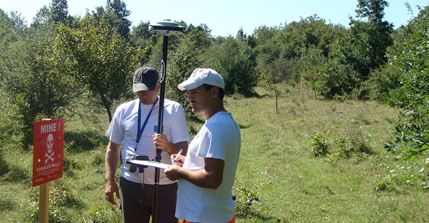
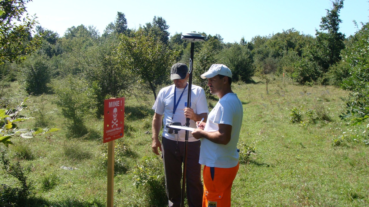
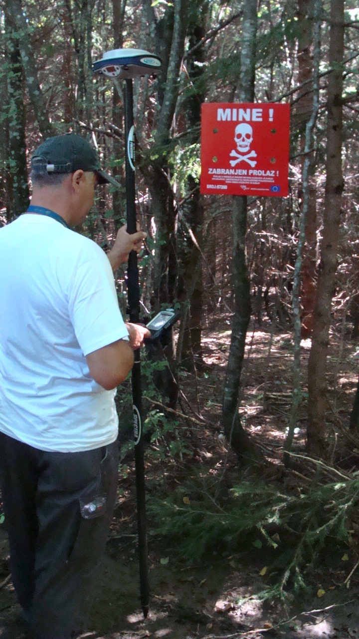
Posavina Without Mines uploads the data it receives from BH MAC into its Spectra Precision ProMark 800 recently purchased through a grant it received to acquire a GNSS capability. Each warning sign is positioned with the aid of the ProMark 800 and assigned a unique serial number. A list of the serial numbers, coordinates and photos of each site comprises a permanent record and database that is submitted to BH MAC.
Photo: Spectra Precisions
Posavina Without Mines had been using an older model handheld GIS GPS for the job. However, according to Ivan Markovic, a Posavina Without Mines spokesperson, “It was producing errors up to two meters necessitating follow up surveys and the involvement of supervisors to rectify the errors.” After reviewing alternative solutions to solve the problem, Posavina Without Mines contacted Gauss Geoinformation Systems.
The ProMark 800 rover and base station system was chosen for its ease-of-operation, excellent accuracy and light weight, an important feature because it is often used in difficult and virtually inaccessible terrain. “On our limited budget, we are very pleased with the accuracy and simplicity of the ProMark 800, and the high-quality training provided by Gauss,” Markovic said.
Spectra Precision has recently replaced its ProMark 800 with a new SP80 GNSS receiver, which offers superior accuracy and reliability, enhanced connectivity capabilities, including Wi-Fi, e-mailing or text messaging, and advanced anti-theft protection.
At InterGeo 2014, James Van Rens, chief executive officer of Riegl, explains the launch of the RiCopter UAV with LiDAR integration, and its designer gives a live demonstration of the UAV in flight. The show was held October 7-9 in Berlin.
The unmanned aerial vehicle is a survey-grade unmanned scanning platform for a variety of demanding applications, such as corridor, power line, or railway mapping.
The high-performance UAV can be equipped with the Riegl VUX-1 survey-grade LiDAR sensor to offer a fully integrated turnkey solution. The RiCopter platform design includes a fully integrated Riegl VUX LiDAR sensor, IMU/ GNSS unit with antenna, control unit, and up to four optional cameras providing measuring characteristics of a 330-degree field of view, 500,000 measurements per second, and 10-millimeter accuracy.
The class 1 unmanned aircraft system can be flown at a maximum operating altitude of 550 meters with a maximum take-off mass of up to 25 kg and a maximum payload of 16 kg, providing a long flight endurance of 30 minutes.
RiCopter flight characteristics are smooth and stable in hovering positions, as well as on demanding flight maneuvers under challenging conditions.
Allen Crawford of Tallysman Wireless Inc. details the company’s GNSS antennas at InterGeo 2014, including a new product Tallysman Wireless plans to launch in the first quarter of 2015.
As European satellites offer a possibility to improve the efficiency of train control systems, GNSS technology is starting to gain momentum in the rail sector. To promote the role of GNSS in this important sector, the European GNSS Agency (GSA) recently exhibited at Innotrans — a leading rail transport tradeshow.
EGNOS can and, in the future, Galileo will provide continuous and highly reliable positioning service — helping increase the competitiveness of rail among other modes of transportation. Currently, GNSS in European rail is primarily used within non-safety-of-life applications, including asset management and passenger information services. However, the latest technological developments show that augmented GNSS, together with specific sensors, can help satisfy the stringent CENELEC Safety and Integrity Level requirements.
As a result, the rail sector has an increasing demand for cost-effective and innovative GNSS applications for both safety critical and non-safety critical purpose. For example, in the safety-critical domain, GNSS-based applications can provide signaling and autonomous train control. In the non-safety critical domain, GNSS is helping improve the performance of asset management and passenger information systems.
Showcasing the E-GNSS Advantage
With rail becoming an important market segment for GNSS technology, and to put emphasis on the many benefits E-GNSS can bring the rail sector, for the first time the GSA exhibited at a rail tradeshow. At Innotrans, one of the leading international tradeshows for the sector held September 23-26 in Berlin, the GSA showcased the EGNOS advantage for rail.
Joining a panel discussion hosted by the European Railways Agency (ERA) entitled “How Heaven Could Support European Train Control System (ETCS),” GSA Head of Market Development Gian-Gherardo Calini explained how European GNSS can serve as a solution to some of the problems the sector currently faces.
“Although rail will become a major market for E-GNSS, it is already providing benefits, such as helping to improve safety,” he said. “Our role at the GSA is to serve the end user by making sure the technology delivers the necessary solutions.”
Calini acknowledged there are challenges to the sector’s full adoption of GNSS, but stated that other sectors have overcome challenges and are benefiting from E-GNSS: “It is a successful reality in other transport sectors, especially aviation, and we must focus on building from these experiences,” he said.
The ERTMS/ETCS is a major industrial project that aims to replace Europe’s different national train control and command systems. The deployment of ERTMS will enable the creation of a seamless European railway system with aligned signalling — essential to increasing the competitiveness of European railways.
Europe’s GNSS systems — Galileo and EGNOS — are actively contributing to the needed evolution of the ERTMS. One example of this long-term perspective is the Shift2Rail Joint Undertaking, whose objective is also to support the adoption of GNSS in the rail sector. Within this undertaking, it is foreseen that both Galileo and EGNOS will be brought into ERTMS standards and foster European GNSS adoption in the area of Low Density Lines.