Eric Gakstatter, contributing editor of GPS World and Geospatial Solutions, talks with Sarah Liu of Supergeo Technologies, Inc., about the company’s GIS solutions for worldwide users while at InterGeo, held October 7-9 in Berlin.
Category: Applications
-
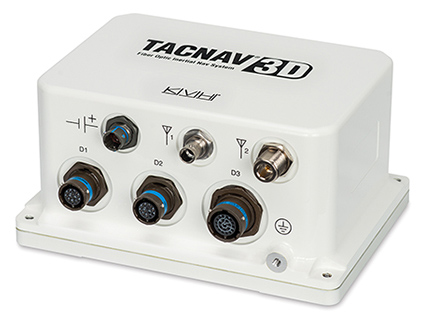
KVH Receives $19 Million Order for FOG-Based Navigation Systems
The TACNAV 3D, by KVH Industries. Photo: KVH Industries KVH Industries, Inc., has received a $19 million contract for the delivery of a new fiber optic gyro (FOG)-based tactical navigation system for use by an international military customer in an armored vehicle application. A variant of KVH’s TACNAV FOG product and KVH’s new TACNAV 3D, the system provides continuous high-accuracy position and orientation even when GPS is lost or jammed.
Work on the contract began in July under a letter contract, and hardware shipments for this order are expected to be made in 2015 and 2016. Program management, engineering services, and out-year support services will be provided as part of this order.
“KVH’s TACNAV navigation solution is an important tool for U.S. and allied warfighters, providing precision navigation as well as coordination of vehicles in critical situations,” said Dan Conway, executive vice president of KVH’s Guidance and Stabilization group. “The system serves as a crucial resource for navigation and battle management, and even as a backup in GPS-denied environments, keeping soldiers safe and out of harm’s way wherever they travel. This new order reaffirms the value of KVH’s TACNAV products for international militaries, and adds to our backlog for the coming years.”
All of KVH’s TACNAV military vehicle navigation systems provide unjammable precision navigation, heading, and pointing data for vehicle drivers, crews, and commanders. TACNAV can also serve as a heading and position source for situational awareness. The TACNAV system ordered is a FOG-based navigation and pointing solution, which is designed to ensure precise navigation data regardless of GPS availability as well as automatic “drive and calibrate” capability. It features a compact design, continuous heading and pointing data output, and a flexible architecture that allows it to function as either a standalone navigation module or as the heart of an expanded, multifunctional TACNAV system. The system is designed to integrate with Battle Management Systems (BMS) and is a vital component for effective battlefield management.
TACNAV systems are currently in use by the U.S. Army and Marine Corps, as well as many allied customers including Canada, Sweden, Great Britain, France, Germany, Spain, Egypt, Botswana, Australia, New Zealand, Saudi Arabia, Taiwan, Romania, Poland, Turkey, Malaysia, Switzerland, South Korea, Singapore, Brazil, and Italy.
-
Loctronix IDS Captures Real-World GPS Jamming Interference
A newly published white paper by Loctronix Corporation presents preliminary test results of its Interference Detection System (IDS), which included capturing two separate incidents of intentional interference caused by a sweep jammer device. On October 23, Loctronix will host a webinar, “Detecting GNSS Interference in the Wild,” based on the findings revealed in the white paper “Catching a Jammer.”
In recent tests, the IDS ran continuously for 24 hours monitoring for potential interference originating from traffic on a nearby highway, SR-522, passing through Woodinville, Washington. “In a single day, the IDS detected two separate instances of a sweep jammer moving along the highway,” noted Loctronix Founder and CEO Michael Mathews. “These discoveries were unexpected, given the relatively short monitoring period and the fact that SR-522 is not a heavy truck-route.”
“The two interference events were likely caused by sweep jammers installed within a vehicle’s interior. The intercepted signals exhibited significant variations in amplitude probably caused by the jammer antenna non-uniform radiation pattern as the jammer vehicle passed through the IDS antenna beam pattern,” Mathews added.
Intentional interference is designed to prevent a GPS receiver from acquiring and tracking signals. The use of jammers is in the U.S. is illegal; however, they can still be purchased for as little as $30. Thousands of GPS jammers are purportedly in use throughout Europe and several parties have been caught illegally jamming GPS in the U.S.
Loctronix developed the IDS to identify, characterize, and ultimately geolocate GPS interference. When interference is present, the system analyzes the interference for signal structure and notifies operators if the threat is significant.
The IDS is highly portable, simple to use, and cost-effective, Loctronix said. The system is based upon the Loctronix ASR-2300 software defined radio platform, making it readily configurable (from a single mobile detector to a multi-sensor network array) to monitor additional GNSS bands and, potentially, cellular bands.
Loctronix’ webinar, ”Detecting GNSS Interference in the Wild,” will be held October 23, 10-11 a.m. PDT.
In the video below, Michael B. Mathews, Ph.D., CEO and founder of Loctronix, tells GPS World about the IDS at the ION GNSS+ Conference, held September in Tampa, Florida.
-
Leica, Aibotix, and Headwall Offer Airborne Sensor Solution

The Aibotix X6. Leica Geosystems, Aibotix and Headwall Photonics are offering an integrated high-performance airborne sensor solution using a hyperspectral imager and the Aibot X6 unmanned aerial vehicle (UAV). The Nano-Hyperspec sensor is optimized for size, weight and power to enable aerial acquisition of all spectral and spatial data within the scene of interest. A UAV with integrated Headwall sensor has been successfully flown and was presented at InterGeo 2014, held last week in Berlin.
Precision agriculture, forestry, geological research, and environmental monitoring are application areas that can benefit from the airborne hyperspectral imaging solution, the companies said. Equipped with the hyperspectral imager, the Aibot X6 can, for example, take pictures of fields or vineyards to determine the chlorophyll content, plant health, and invasive species, and offer farmers information on the state of the plants and harvest. By means of UAV and hyperspectral imager, farmers can measure before harvest, where the grain is driest or should be mowed first. Or, they can determine where rain has washed away fertilizer and where they must re-fertilize.
For geological mapping, landfills and open mine sites can be overflown to quickly and efficiently track precious metals or minerals. Environmental monitoring and research to derive contamination of soil or water can be determined spectrally from the air quickly using the Aibotix UAV and Nano-Hyperspec sensor.
The Nano-Hyperspec sensor measures 76.2 x 76.2 x 119.4 millimeters and weighs less than 0.68 kg. The sensor is integrated with a high-speed data processor and high-capacity flash storage. It collects image data across 640 spatial bands and 270 spectral bands with a Visible-Near-Infrared (VNIR) range of 400-1000 nm. The field of view is exceptionally wide, meaning that flight swath efficiency is maximized to cover as much territory as possible while the UAV is aloft. Further, it delivers crisp image data not only directly underneath the flight path but off to the edges.
The integrated data storage is 480 GB, which will yield more than two hours at a frame-rate collection rate of about 100 fps, which is matched to the actual performance of the UAV itself. The direct-attached GPS with IMU yields the ability to generate ortho-rectified imagery data products.
The Nano-Hyperspec comes pre-loaded with an airborne version of its Hyperspec III application software that manages sensor operation, image acquisition, and sensor performance while aloft. Hyperspec III software is designed to work in a complementary fashion with the GPS/IMU as well as incoming LiDAR data to collect spectral data and generate a completely integrated hyperspectral data cube.
-
Geneq Talks Pre-Launch of SXBlue III GNSS RTK Receiver at InterGeo
Richard Desrochers discusses Geneq, Inc.’s pre-launch of its SXBlue III GNSS RTK Receiver while at the 2014 InterGeo Conference and Trade Fair held October 7-9 in Berlin. -
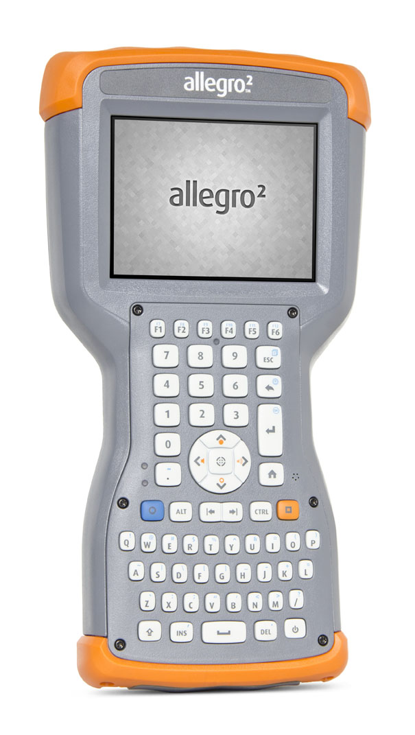
Juniper’s New Rugged Handheld Designed for Data-Collecting Efficiency
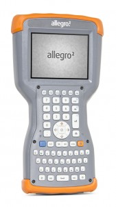
The Allegro 2 by Juniper Systems. Photo: Juniper Systems Juniper Systems announced its newest rugged handheld computer, the Allegro 2, at the InterGeo 2014 trade show, held September 7-9 in Berlin. The handheld is the latest in the company’s Allegro product line, “with every bit of reliability,” the company says, but now with some major advancements.
According to Juniper Systems, the Allegro 2 was designed for data-intensive applications, with meticulous attention paid to the engineering and design of the handheld to maximize efficiency and precision, both of which are critically important to high-volume data collection.
Compared to the Allegro 1, the Allegro 2 has a newly designed keyboard in a QWERTY and numeric layout, with large, glove-friendly buttons for rapid — even non-visual — data entry. The new handheld features a custom Sun-to-Shade display that is 20 percent larger than the previous Allegro. It offers excellent visibility in any lighting conditions, the company said.
The Allegro 2 is powered by an Overtime Technology battery, providing a 20+ hours of runtime. Its touchscreen uses capacitive technology, providing excellent durability, as well as crystal-clear imagery and greater sensitivity to touch, Juniper Systems said. The Allegro 2 has significantly enhanced GNSS performance, extended Bluetooth range, camera and video options, and a more powerful processor than the Allegro 1.
“The Allegro 2 is our next-generation product, and it includes all of the latest enhancements available in its sister product, the Archer 2,” said John Florio, product manager at Juniper Systems. “The Allegro 2 was built from the ground up, based on user feedback on the jobs they have to do. Whether the customer is grading lumber in a log scaling yard, running a robotic total station, or performing a close-interval pipeline survey, the Allegro 2 is the best solution for the field today.”
The Allegro 2 is scheduled to begin shipping in November.
-
New Version of PPP-Wizard Demonstration Software Published
A new version of the open source PPP-Wizard user software has been published. The link to download the wizard is being provided on request, so the International GNSS Service (IGS) can keep track of interested users.
The PPP-Wizard is defined as a precise point positioning with integer and zero-difference ambiguity resolution demonstrator. Available for non-commercial purposes, it performs real-time PPP using corrections streams provided by the IGS Real Time Service. It features:
- GPS and GLONASS code and phase measurements (mono or dual frequency)
- Ambiguity resolution on GPS thanks to the new standardized phase biases messages (with the compatible CLK91 stream)
- Advanced RAIM
- SBAS iono for single-frequency receivers (u-blox and nvs receivers)
- Fast reconvergence using iono estimation
- Compatibility with rtklib and BNC (rtrover interface)
- Multiple receivers processing
- Preparation for augmented regional networks (tropo & iono interface)
- C/C++ portable and light implementation
The PPP-Wizard demonstrator is a “proof of concept” of the zero-difference ambiguity resolution method developed in the orbit determination service at CNES.
-
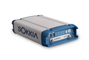
Sokkia Announces Next-Generation Geodetic Reference Receiver
The Sokkia GNR5 geodetic receiver. Photo: Sokkia Sokkia announces the latest addition to its line of geodetic GNSS reference receivers — the GNR5. Making use of 452 channels optimized to track the full GNSS spectrum, the GNR5 is designed to assign any visible signal to any available receiver channel.
“The GNR5 is a comprehensive connectivity solution,” said Charles Rihner, vice president of the GeoPositioning Group. “Whether using the built-in Bluetooth and Wi-Fi wireless communication options, or standard Ethernet, serial and USB connections — the system provides a powerfully integrated reference station that is capable of tracking the GPS, GLONASS, Galileo, Beidou, QZSS and SBAS constellations.”
Additional features include high-precision code and carrier phase measurements up to 100 Hz, Power over Ethernet (PoE), and advanced receiver management features.
The new receiver is on display at InterGeo 2014, being held this week in Berlin.
-
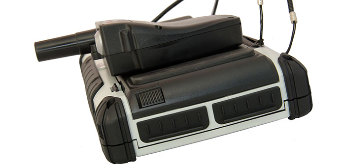
Altus, Entegra Combine to Provide Tough Tablet with RTK Positioning

The APS-GeoPod. Photo: Altus Positioning Systems Altus Positioning Systems, a Septentrio company, has integrated its APS-GeoPod product with Entegra Technologies’ Crossfire Pro Tablet. This collaboration, targeting the oil and gas, survey, GIS and transportation industries, provides a high-performance tablet-based solution for enabling ultra-precision RTK of sub-meter or centimeter accuracy.
Altus is showcasing the APS-GeoPod and Crossfire Pro tablet, along with the full range of Altus products, at booth A1.060 and outside Booth FG.006 at InterGeo 2014 being held this week in Berlin, Germany.
According to Altus CEO Neil Vancans, the Altus APS-GeoPod and the Entegra Crossfire Pro Tablet provide a combination of precision, performance and features that make it ideal for energy services, land surveys and other GIS-related applications.
APS-GeoPod is a compact GPS/GLONASS RTK and DGNSS receiver that adds high-precision RTK positioning to USB-compatible tablet PCs. “This unique product gives users the convenience of adding RTK precision to any on-board application on mobile devices geared to the field service professional,” Vancans said.
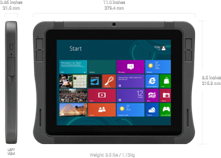
The Entegra Crossfire Pro tablet. Photo: Altus Positioning Systems APS-GeoPod features include:
- Compact dual-frequency GNSS module
- Low power consumption (<1 Watt)
- USB 2.0 interface
- Internal L1 GPS/GLONASS antenna
- NMEA integration with GIS software
The Crossfire Pro tablet features the multi-touch interface and communication capabilities of smartphones, the large display and ergonomics of consumer tablets, and the daylight-readable screen and durability of rugged tablets. Safety features include UL 1604 Class I/Division II certification for operation in hazardous locations. To users, Crossfire Pro delivers a customizable tablet for exacting daily activities, resulting in greater efficiencies, response times, productivity and customer service levels, the companies said.
Crossfire Pro tablet features include:
- ADAPTIVE PERFORMANCE — Powerful, latest-generation processors, wireless communications, connectivity, and outdoor-viewable displays
- ADAPTIVE EXPANSION — Standard and custom expansion modules — tailored to suit your workflow
- ADAPTIVE CONNECTIVITY — Flexible user interactivity, including multi-touch displays (finger, glove and stylus), configurable I/O ports, clamshell keyboard and smart docking stations
- ADAPTIVE RUGGEDIZATION — Variations in ruggedness to stand up to drop, shock, moisture, dust, temperature, and more.